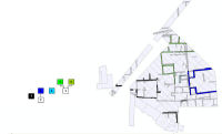
Figure 24: The East Field at Isthmia, addition of Sub-Phase 7, Plan and Harris Matrix.
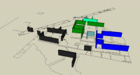
Figure 25: The East Field at Isthmia, addition of Sub-Phase 7, Model.
Figure 24: The East Field at Isthmia, addition of Sub-Phase 7, Plan and Harris Matrix.
Figure 25: The East Field at Isthmia, addition of Sub-Phase 7, Model.
This next sub-phase, a series of constructions that maintain continuity with the standing remains of the 'blue' (2-4) and 'black' (7) sub-phases but were built some time afterwards, heralds a sequence of continuous building activities that served to define the overall spatial organisation of the site until its wholesale destruction, probably sometime in the 4th century CE. It is now that we may begin to recognise the true scale of the site and its building program. Instead of the simple and isolated Roman houses imagined by Clement, we found large and extensive building complexes that demonstrated a considerably sophisticated, and therefore probably a centralised, system of organisation. The first of these is represented by the 'green' walled structure/s that in-filled the central area between the earlier 'blue' and 'black' structures - sub-phases 5 and 6 (Figs 24-25). These were at least two separate, but associated, large structures, both of which were very likely to have continued northward as far as the theatre itself, more than 30m away.
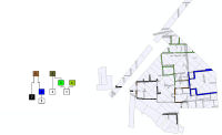
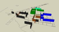
Figure 26: The East Field at Isthmia, addition of Sub-Phases 8-9, Plan and Harris Matrix.
Figure 27: The East Field at Isthmia, addition of Sub-Phases 8-9, Model.
Just to the south of the 'green' structure a new construction (brown) reorganised the space once more, filling the area between the earlier 'blue' and 'black' buildings (Figs 26-27). Little more can be inferred from these constructions at this stage, other than to suggest they were built as an attachment to the 'blue' and 'green' buildings rather than as an isolated structure, and served to organise a portion of the space between them.
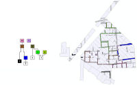
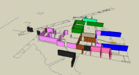
Figure 28: The East Field at Isthmia, addition of Sub-Phases 10-11, Plan and Harris Matrix.
Figure 29: The East Field at Isthmia, addition of Sub-Phases 10-11, Model.
Much more significant developments can be recognised in the following sequence of building activities. New structures were introduced at this time, and existing buildings rebuilt. These new activities (sub-phase 10), represented by the 'pink' walls in plan, produced a new building in the south-west corner of the excavated site (Figs 28-29). New walls closed off the southern edge of the area that had originally been open, cutting across and over a large pit that provided access to the drainage tunnels. These walls essentially constituted a rebuilding of the early 'black' building at this time (see Figs 24-25). This involved the rebuilding of the latter's boundary walls, probably in conjunction with the construction of a new drainage scheme (sub-phase 12) that had originally served to terrace the landscape. It also involved the building of a new set of walls that divided the interior space of the 'black' building (Figs 30-32). The apparent extent of this rebuilding suggests major changes, or at least renovations, to a building in the south-west area.
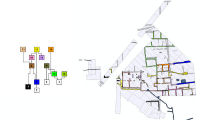
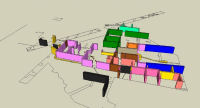
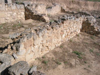
Figure 30: The East Field at Isthmia, addition of Sub-Phases 12-14, Plan and Harris Matrix.
Figure 31: The East Field at Isthmia, addition of Sub-Phases 12-14, Model.
Figure 32: The East Field at Isthmia, interior walls of the south-west building during sub-phase 12.
Additional construction in the south-eastern quarter of the East Field occurred at about the same time as the 'pink' walls were constructed in the south-west. The 'lavender' walls of sub-phase 11 form a suite of south-facing rooms that create one of the few places with a regular plan or a sense of order that is visible in the extant structural remains today. In the eastern two rooms traces of facing plaster have survived in the corners and near the current ground surface, indicating that these rooms also had similar decorative treatment. Though physically separate, the similarity in construction style - opus incertum with poor, mud mortar - of the 'pink' (sub-phase 10) and 'lavender' (sub-phase 11) walls, as well as their similar stratigraphic relationships to other constructions (both were built after sub-phase 8 and before sub-phase 12), provide evidence for a flurry of building activity across the south of the site. Moreover, the north side of these 'lavender' walls was planned to accord with pre-existing architecture, serving to enclose and partition the remaining space between the southern wall of the 'blue' building and its associated 'brown' walls, and bounding the area to the west.
In conjunction with the building of the 'lavender' walls, the early 'blue' building was reorganised for the first time, in that the small south-western and north-western rooms were removed to open out the central area further. This property appears to have retained its original form, though access to the additional spaces to the west was probably added at this time. Further study of this building in the second and third phases of this project is needed, but at this preliminary stage it seems that this central space held much spatial and functional significance and that some cultic activities were played out here throughout the life of the building (Figure 23). This is suggested by the cutting of a tunnel through the middle of the space, its entrance being located in the centre of the room to face toward a circular masonry feature that might have been an altar (Figure 20). The tunnel was approximately 9.4m in length and headed towards the north-west, but without a proper exit. Instead a small vertical opening in the ceiling of the tunnel, adjacent to the circular feature, gave some access between the two (Figure 33). Some scholars have identified this tunnel as a place of cult activity, mostly because it does not seem to conform to any kind of secular use (Peppers 1979; Marty 1993; Wohl 2005). Once we have a fuller contextualised understanding of the building we hope to be able to interpret this unusual feature more succinctly.
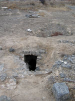
Figure 33: The East Field at Isthmia, access chute to the end of the tunnel, adjacent to the circular feature (at right, but only partly in view - see inset of Figure 20), looking south-east.
This circular feature is itself intriguing in that it may have replaced an earlier feature centred between the two rooms of the earlier phase (Figure 20). Unfortunately a significant section of it was probably destroyed in the first excavations. This is inferred by its general circular shape, except for the north-eastern quadrant that is either missing, or was never built in the first place. We suggest that the excavators destroyed it, perhaps unconsciously, with our suspicions being aroused by the fact that the precise section that is missing corresponds with the exact line of the first trench that was cut through this area in the 1970 season. Moreover, this feature is not mentioned in the notebooks. It was very probably related to the tunnel and, on the basis of its construction and mortar types, associated with a series of newly installed water features that channelled water between several different buildings across the site. If so, this would support a notion of a centralised organisational authority. These water features, as with the central circular feature of the 'blue' building itself, are represented on the plan in yellow (sub-phase 12) and were installed as part of the 'pink' sub-phase (10) (Figs 30-31). Although not all of these 'yellow' water features can be grouped together through any observable physical connection, they share exactly the same mortar type (as based on the matrix of the mortar and its inclusions) as well as the same construction style.
The final additions to the areas west of the 'blue' building, shown as 'orange' sub-phases (13 and 14), likewise have no physical relationship to each other, nor do their construction styles, mortars, or even building materials match. However, their stratigraphic relationships place them both in the last phases of the site. More importantly, they complete the subdivision of this area and mirror each other by creating a set of small rooms which may have permitted communication among them from north to south, along this western side of the 'blue' building.
These wholesale developments to the southern part of the site represent the final structural and spatial changes before the entire area was destroyed during a single event. Datable fill material from this destruction event, pulled from the tunnel, suggests that it occurred in the 4th century CE. Of considerable importance to this discussion is a hoard of 97 coins that Clement uncovered in the East Field. Of these, 76 were datable, and none of these were struck after 395 CE, leading him to believe that the hoard, found within a 'fill', must be associated with the Alaric invasion of the region in 396 CE (Beaton and Clement 1976, 277). More work must be done in subsequent field seasons to determine the contextual stratigraphic validity of this material so that we might refine the date and cause of this important episode in the East Field.
© Internet Archaeology/Author(s)
URL: http://intarch.ac.uk/journal/issue24/3/5.4.html
Last updated: Mon Jun 30 2008