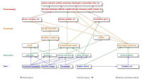
Figure 27: A graphical representation of the tiered levels of transcription.
The levels that were established for this pilot study were (Fig. 27):
the basic information – rectified and located photographic imagery; satellite imagery (spatially referenced); metadata;
interpretative transcription wall lines – digitised interpretation of wall lines. Each wall line is an individually numbered poly-line, joined to other walls (poly-lines) where appropriate. Each wall element is linked to the database which records attributes, such as suggested wall thicknesses and the specific aerial photograph on which the wall line was identified;
interpretative transcription doorways – in some circumstances possible doorways can be distinguished/conjectured. Where this occurs these are annotated on a separate overlay;
interpretative transcription streets and alleys – identification of segments of streets/alleys (drawn as poly-lines). Each element is linked to the database, with degrees of confidence, documentation of possible widths, etc.;
interpretative transcription linear structures – identification of segments of other linear features, such as canals and defences (drawn as poly-lines). Each element is linked to the database, with documentation of possible widths, etc.;
interpretative transcription rooms – where possible, the identification of specific rooms. Drawn as closed polygons. Each element is linked to the database, with possible areas, dimensions, etc.;
interpretative transcription courtyards/open spaces – identification of potential open spaces within building complexes. Drawn as closed polygons. Different shading is used to distinguish these visually within the building blocks. Each element is linked to the database, with possible areas, dimensions, possible functional attributes (e.g. gardens), etc.;
interpretative transcription building complexes – grouping walls/rooms/courtyards into building complexes: these represent areas of built space rather than, at this stage, attempting to distinguish specific properties. Drawn as closed polygons. Each element is linked to the database, including functional groups (public/domestic/etc.);
interpretative transcription specific properties – identification of possible specific properties, such as a housing unit or a public building complex (e.g. mosque). This is certainly not possible for the whole of the built space, as there is not sufficient clarity/definition in all areas to be certain of the boundary between one property and another. Drawn as a closed polygon. Each element linked to the database, including functional groups (public/domestic/etc.), and, where possible, discussion of possible functional type (e.g. caravanserai, mosque, madrasa);
interpretative transcription the urban landscape – broad brush characterisation of urban landscape, building on the preceding layers, to suggest zones, schematic plans, circulation routes, built/unbuilt space, chronological development, etc. – each element/overlay documented and linked to the database.
Each of these interpretative transcriptions is held in a different GIS layer, which also allows line colours and thicknesses to be easily changed. A database will be used to hold information on the digitised decision-making and the inter-relationships of specific built elements (e.g. walls, rooms, buildings, blocks), unbuilt space (e.g. courtyards, piazzas, gardens), communication space (e.g. alleys, streets), and linear urban structures (e.g. canals, defences).