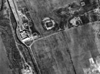
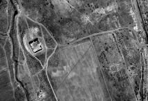
At least two further substantial structures lay further south, just to the east of the Greater Kyz Kala. Unfortunately, these were very badly damaged by modern agriculture: although they were quite distinct on the 1970s APs (Fig. 60), they had been heavily eroded by the time the 2001 satellite image was taken (Fig. 61). It is not clear what function these structures served, although a further caravanserai is a possibility.
Figure 60: Two substantial structures are clearly visible as earthworks to the east of the Greater Kyz Kala on the 1970s APs.
Figure 61: The 2001 IKONOS satellite image, covering the same area as in the Figure 60 AP, showing the scale of agricultural damage (and new roads) that has taken place. The structures clearly visible on the APs are not easily recognised today.
There are clearly other structures within the study area; unfortunately the 1970s AP coverage in this area is poor, and the satellite image post-dates the damage to the area through modern agriculture. We therefore have to see through a blur of modern agricultural patterns such as field systems, ploughing and new canals (Fig. 61). Nevertheless, it is evident that there were other structures within the area: for example, regular shapes to the north of the first caravanserai complex suggest at least two distinct building complexes (Fig. 60), while in the south of the area regular soil marks suggest enclosures or building complexes (Fig. 61). What is clear, which is unsurprising, is that this was a complex landscape, with numerous building complexes and enclosures, set within an organised and managed landscape.