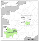


Figure 1: Location map of southern Burgundy
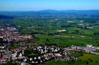
Figure 2: Aerial view of Autun and Mont Beuvray
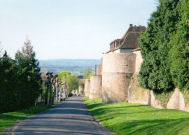
Figure 3: Walls of Autun
This article presents the results of a pilot programme of fieldwork recently carried out in the Arroux Valley, Saône-et-Loire. The valley lies in southern Burgundy, at the foot of the Morvan massif, which it separates from the granite hills to the south. In the late Iron Age, this region was inhabited by the Aedui, one of the most powerful peoples of central France and an early ally of Rome. Their principal stronghold, the well-known oppidum at Mont Beuvray (Bibracte), high in the Morvan, was extensively excavated in the 19th century by Bulliot and Déchelette, whose research established the oppidum as one of the type-sites for the European Iron Age (Déchelette 1904; Collis 1984; Fichtl 2005a). During the Augustan period, Mont Beuvray was succeeded as the capital of the Aedui by the new foundation of Autun (Augustodunum), which lies 27km away from the oppidum, beside the banks of the Arroux. Autun quickly developed into one of the most important cities of Roman Gaul and a noted centre of learning and culture (Février et al. 1980; Drinkwater 1983; Woolf 1998), and to this day still possesses many of its principal Gallo-Roman monuments.


Figure 1: Location map of southern Burgundy
Figure 2: Aerial view of Autun and Mont Beuvray
Figure 3: Walls of Autun
Since 1984, the resumption of excavations on Mont Beuvray, within the framework of an international research programme instigated by the late President Mitterand, has transformed our knowledge of the pre-Roman capital of the Aedui from the period of its foundation in the later 2nd century BC to its heyday in the mid- to late 1st century BC (e.g. Gruel and Vitali 1998; Guichard 2003). Over the same period, there have also been major new excavations in Autun, mostly in advance of development (e.g. Chardron-Picault and Pernot 1999). Iron Age and Gallo-Roman rural settlement in the surrounding region has, however, received less attention. An inventory of archaeological sites in the environs of Mont Beuvray was undertaken as part of the new programme (Büchsenschütz and Richard 1996) and the area has been regularly over-flown by René Goguey, but there have been relatively few new discoveries and - at least when the present project started - virtually no fieldwork in the surrounding region.

Figure 4: Mont Beuvray
This lack of investigation has much to do with present-day land use. The Morvan used to be extensively cultivated (Büchsenschütz and Richard 1996), but nowadays is mainly pasture or woodland. A similar picture prevails down in the Arroux valley, where the vast majority of fields are used to provide pasture for the region's famous Charolais cattle. Even in the lower lying areas, only a handful of fields are cultivated, severely limiting the possibilities for either aerial reconnaissance or conventional fieldwalking. The cultivation regime further restricts the possibilities for fieldwalking, as ploughed fields are almost never left to weather long enough for archaeological material on the surface to become readily visible.
The consequence is that outside Mont Beuvray and Autun themselves, our knowledge of the settlement pattern here in the heart of Aeduan territory is negligible, be it for the period preceding the foundation of the oppidum, during the main period of occupation of either capital, or indeed in Late Antiquity and the early Middle Ages. It is probable, however, that their hinterland was densely settled at most periods, if only the means could be found to locate and characterise the relevant sites. There have been regular chance discoveries over the years and several significant sites have been excavated, albeit mostly some time ago and with limited surviving records (Bigeard 1996; Rebourg 1993; 1994); these include substantial Gallo-Roman villas in the communes of Monthelon and La-Grande-Verrière (Saône-et-Loire); the well-known temple complex at the source of the river Yonne (Nièvre); and a possible sanctuary complex at Poil (Nièvre). More recently, Goguey's aerial researches have revealed cropmarks of some small square ditched enclosures in the Morvan, most of which appear likely to be funerary (Goguey 1996).
Given that the Arroux valley represents the main area of relatively flat and low-lying ground in the environs of both Mont Beuvray and Autun, we might reasonably expect it to have been intensively exploited in the later Iron Age and Gallo-Roman periods as well as at other times. This appears to be confirmed by the only two systematic investigations that have taken place there. In 1991, a local archaeologist, Roland Niaux, followed the installation of a gas pipeline along the banks of the Arroux between Autun and Etang-sur-Arroux, a distance of 15km, in the course of which he noted Gallo-Roman finds at no less than 25 separate locations, as well as both prehistoric and medieval material (Niaux 1991-2). Further downstream, fieldwork by Carole Crumley in the neighbourhood of Toulon-sur-Arroux has shown that numerous Iron Age and Roman sites can be found by walking the arable plots that do exist (Crumley and Marquardt 1987).
© Internet Archaeology/Author(s)
URL: http://intarch.ac.uk/journal/issue25/3/1.html
Last updated: Wed Oct 29 2008