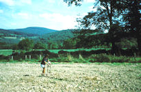
Figure 37: L'Haut de Champs; with granitic hills on the south bank of Arroux
Two fields 500m to the south-west of Les Chaumes are known collectively as L'Haut des Champs, the larger, western, one under pasture, the eastern one in cultivation at the time of the survey (though subsequently pasture). One definite Gallo-Roman structure and two possible ones were identified here, while fieldwalking revealed a dense concentration of pottery, tile and building stone, extending over approximately 0.5 ha in the eastern plot.
The eastern field was first linewalked, then followed up with both more detailed gridded surface collections (in two separate years) and gradiometry survey. This revealed a noisy area of readings just to the south of the pipeline, with a couple of linear features partly bounding it and running off from it to the east. Resistivity survey in the same area showed slightly higher readings. Together they suggest some kind of building, over an area c. 30m across, although no detailed plan could be identified.
The geophysical results were perfectly complemented by the surface collections, which provided matching ceramic and tile distributions (Figs 38-39). The bulk of the material was of Roman date, but the finds also included Republican wine amphorae and possible late La Tène coarsewares. Parts of two Roman querns were also recovered, as well as a retouched cortical flake.

Geophysical survey also took place in the pasture field to the west. Again there were clusters of magnetic noise, which included traces of linear features that correlated with areas of high-resistance anomalies. Two particular areas were noted, both in the part of the field closest to the previous field. These three concentrations in L'Haut des Champs are all likely to be part of the same complex. Unfortunately, the lack of mole activity in the pasture field meant that no ceramic material was collected from here!
The geophysics also revealed a number of linear features in the top part of the field, running broadly parallel to the main road, but 20m to the south, close to the edge of the northernmost of the three geophysical clusters. These linears may represent traces of earlier road alignments or roadside ditches.
The pottery from L'Haut des Champs (UF 33, 34, 64, 75)
No. of sherds: 517; weight: 6449g
This was the largest assemblage of pottery collected in the survey, although this was also the most intensively walked field. Unsurprisingly, the assemblage provides the widest range of both fabric and forms. Imported amphorae include several examples of Dressel 1 and Dressel 20. Three sherds in Tarraconensian fabrics may be either Pascual 1 or Dressel 2-4 types. A single rim of a Graeco-Italic vessel, a handle of an Italian Dressel 2-4, and a body sherd from a Lamboglia 2 type were also found. Graeco-Italic amphorae date to the 2nd century BC (although there are some suggestions that the form sometimes remained in currency into the 1st century BC; J.R. Collis, pers. comm.). Lamboglia 2 does not appear on French sites after the third quarter of the 1st century BC, having originated in the second half of the 2nd century BC (Loughton 2003). It is likely that both are pre-conquest imports.
The presence of Graeco-Italic and Lamboglia vessels alongside several sherds of Dressel 1, points to late La Tène occupation on or near this site. Although coarsewares in potentially early fabrics are not abundant, they include fabric B1 (PSMIC), one sherd of which is in a possibly late La Tène form P(AV)5.1 (Fig. 85, 44) although the fabric also occurs in Gallo-Roman forms. Some other PSGROS fabrics (including B2 and R1) may also be of late Iron Age or Augustan date, including P(AV)12.1 (Fig. 86, 53) and perhaps P(AV)15.1 (Fig. 88, 61). Several vessels suggest 1st-century AD occupation, including E(AV)1.1/1.3/1.4 (Fig. 83, 27-29), P(AV)1.1 (Fig. 85, 39), and P(AV)14.6 (Fig. 87, 60).
The other amphorae from the site include the only two Gauloise forms found in the survey, one a flat-bottomed variety from the Gueugnon kilns 40km downstream, and the other from the province of Narbonensis.
A range of other forms and fabrics indicate occupation through the 2nd-3rd centuries AD, seen in flagon forms (CR(AV); Fig. 89, 68, 71, 74, 75), Marmites (M(AV)2.1, 3.2, 3.3, 4.2; Fig. 90, 76, 77, 79, 80) and other coarsewares (Fig. 85, 46, 49), with Rhenish wares of similar date (Fig. 84, 38). The samian also has a 2nd-century AD emphasis (Section 6.4, TS11, 13, 19-21) with significant quantities of later 1st-century AD material (Section 6.4, TS12, 14, 17-8). One vessel form, P(AV)6.1 (Fig. 85, 45) has both 2nd to 3rd and 4th to 5th century parallels, while sherds in fabric B4 might indicate even later activity.
The proportion of PSGROS fabrics in this assemblage is not significantly higher than at nearby Le Grand Champs (Fig. 95). However, the overall impression from the forms and the presence of some coarseware fabrics not seen at Le Grand Champs, is that L'Haut des Champs has earlier antecedents, and may well have been occupied in late La Tène. On the other hand, the proportion of South Gaulish samian here is actually slightly lower (12.5%) than at Le Grand Champs (15.8%), although this may be a function of site status (or the parts of the site examined), since the proportion of finewares at Le Grand Champs is significantly higher.
| Stray finds Linewalked: 10m transects (3.10 ha) Gridded collections | 64 33 34*, 75 | Figs. 83, 84, 85, 86, 87, 88, 89, 90 Diagnostic ceramics (*ceramics collected during gradiometry and numbered as survey grids) Fig. 38 Ceramic distribution Fig. 39 Tile distribution Lithics (not illustrated) |
| Gradiometry survey: 1.0m x 0.5m (5.85 ha) Resistivity survey: 1.0m x 1.0m (2.79 ha) | 34, 52, 54 37, 53, 55 | Fig. 40 Gradiometry results Fig. 41 Resistivity results Fig. 42 Geophysics interpretation |
© Internet Archaeology/Author(s)
URL: http://intarch.ac.uk/journal/issue25/3/5.2.3.html
Last updated: Wed Oct 29 2008