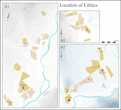
Figure 100: Overview of lithics sites
Figure 100: Overview of lithics sites
Although the fieldwalking was aimed primarily at the recovery of pottery, enough worked flints and flakes were collected during the survey to indicate that there was significant prehistoric exploitation of the terraces of the Arroux and its tributaries. The majority of finds were made in Area 2, including the only two collections of any size: at Ravery, where 25 lithics were found, and Les Chaumes, where another 7 were recovered. Most of the finds can be assigned a broad Neolithic-Bronze Age range. A variety of flint sources are represented. They include the retouched Grand Pressigny 'dagger' blade of late Neolithic or Chalcolithic date found at Ravery. Niaux (1991-2) also reports finding flints here. Only one core was found in the entire survey, at La Bruyère in Area 3; this had apparently been discarded after unsuccessful attempts at flaking.
Apart from Ravery, which sits in the angle formed by the confluence of the Arroux and the Méchet, the lithic findspots are mainly from the edge of the higher terraces flanking the Arroux and the Celle valley. Very few fields could be walked on the lower alluvium, so it would be unwise to infer that this area was void of activity. Indeed, there is a certain amount of evidence, besides the finds from Ravery, to the contrary. At La Grand Corvée, 1.5km to the east of Ravery, and only a few metres higher, is a now-fallen stone known as the Menhir de Monthelon, which was excavated in the 1980s by L. Lagrost. Part of a Middle Neolithic pottery vessel was found in the hole where the menhir had stood, providing a terminus post quern for its erection. A scatter of flint artefacts was also recovered.
According to the report on the excavation, a large assemblage of flint and pottery of Neolithic date was recovered from the edge of the terrace overlooking the menhir about 100m to the north. From the range of material, which includes tools, cores and hammerstones, as well as a 'molette', this was probably a settlement, adding to the impression given by the survey finds, that the edge of the higher terrace was a favoured location for Neolithic habitation. Too little material was collected at Ravery to be certain about the nature of activity there, but it is possible that sites on lower ground, closer to the river, were only exploited seasonally in the drier months, to avoid the risk of flooding.
Despite the limited amount of flint collected, the survey amplifies previous indications that the Arroux valley downstream from Autun was well exploited from at least the Middle Neolithic. The area of Autun itself may have been something of a focus, as indicated by the presence of the Middle Neolithic causewayed camp at Pierrefitte on the right bank of the Arroux (Rebourg 1993, 30; 101; 1998, 149-50). In addition, there appears to be a significant Middle and Late Neolithic settlement at Champ de la Justice, on the left bank of the river 4km upstream from the town, represented by remains of hearths associated with abundant flint and pottery (Rebourg 1993; 1998). There is no evidence of specifically earlier Bronze Age activity in the Autun area, but some of the survey finds may well be of this date.
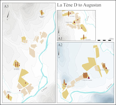
Figure 101: Overview of La Tène D to Augustan sites
The primary aim of undertaking a pilot study in the Arroux valley was to explore the extent to which in this predominantly pastoral landscape, different surface survey techniques could be used to locate and characterise Iron Age and Gallo-Roman rural settlements. To the extent that this proved possible, it should be feasible in the longer term to set the emergence and development of Mont Beuvray and its Roman successor at Autun in a wider context. In particular, we need to know more about the nature of Iron Age settlement in the area prior to the foundation of the oppidum in the late 2nd century BC and whether there was any reduction in the number of rural sites coeval with the move to the hilltop.
We had hoped that it might be possible to use magnetometer survey to identify rectilinear ditched enclosures of the kind associated with fermes indigènes of later Iron Age or Roman date elsewhere in Burgundy and in other parts of France (Section 4.1). In the event, no definite examples of this type of site were identified during the project, but geophysics did succeed in locating some ditch systems of curvilinear form, notably on the hillside below Chevannes farm and at the Les Bois de Monthelon, south-west of the Chantal villa. These could conceivably belong to prehistoric settlements or be of more recent date. As the work at Poil confirmed, there is no reason in principle why Iron Age settlement enclosures should not eventually be located through geophysical survey, if they exist here.
Fieldwalking did, however, permit us to pinpoint a number of possible Iron Age settlements, although - because the relevant ceramic traditions carry on until at least the Augustan period and the majority of fieldwalking finds are undiagnostic - only one of these sites can be considered reasonably certain. As we expected, given the hostile soil conditions, poor surface visibility and lack of weathering, and friability of most protohistoric fabrics, the quantity of potentially Iron Age pottery recovered was very small. The sherds in question occur in both reduced and oxidised coarseware fabrics (Table 4), both wheel-thrown and hand-made, and are found occasionally in probable La Tène D forms as well as and more commonly in early Roman types. In the Arroux survey, they rarely occur independently of Gallo-Roman assemblages and - apart from at L'Haut des Champs - are only represented by a handful of sherds from a single location. Their presence then is suggestive, but by no means conclusive.
A better indicator of possible late Iron Age occupation is provided by sherds of Republican wine amphorae, sometimes from the same location as the coarsewares just discussed, but just as often single finds. Unsurprisingly given the vast numbers present at Mont Beuvray, and other local sites such as Poil and the Sources de l'Yonne, the bulk of the amphorae collected in the survey appear to be from Dressel 1 vessels of Italian origin. At Autun, however, Dressel 1 accounts for only a tiny fraction (<0.1%) of the amphora assemblage, which Olmer (1997) takes as indicating that the bulk of these vessels reached the region before the city was founded at the end of the 1st century BC. This may well be the case, but cannot be used as a definitive indicator of pre-Augustan activity for the survey sites, given the super-abundance of Dressel 1 in Augustan contexts at Mont Beuvray (and indeed at sites all over France).
The strongest candidate for pre-Roman occupation is L'Haut des Champs in Area 2, where a Graeco-Italic rim and a sherd of Lamboglia 2 amphorae - both likely to be pre-conquest imports - were recovered in addition to several fragments of Dressel 1 and probable early coarsewares. The Graeco-Italic vessel in particular is likely to indicate occupation no later than La Tène C2-D1. Other possible candidates for Iron Age settlements are Le Grands Champ, also in Area 2, in the vicinity of the villa at Chantal in Area 1, and at Le Champ de Maison in Area 3. A sherd of Spanish Pascual 1 amphora and other finds from Beaufort suggest occupation there or nearby dating to La Tène D2b or the Augustan period.
This rather sparse evidence is, however, precisely what we might predict if there was in fact a diminution in the number of rural sites at the time that the occupation of the oppidum on Mont Beuvray was at its peak. A scarcity of rural settlement dating to La Tène D2 seems to be a recurrent phenomenon in other regions of France where oppida are found, such as the Paris Basin (Haselgrove 2007), suggesting there could well be a link. There is evidence of similar tendencies closer at hand in eastern Burgundy, where Barral (2005) has examined a sample of eight rural settlements with dating evidence in the plain of the Saône and the Doubs. All eight sites were occupied in La Tène C2-D1, but only one of them (Azé) continues through to the mid- 1st century BC, although another (Authumes) was reoccupied during La Tène D2, apparently after a break in occupation. Not all regions show such a pattern, however. In the Yonne department of northern Burgundy, where Pierre Nouvel has carried out extensive fieldwork, the picture seems to be the opposite, with an increase in the number of sites from the 2nd to the 1st century BC (Nouvel 2004).
Throughout France, it is common for sites to be founded in the Augustan period, although there are regional variations (Haselgrove 1990; 1996). With the probable exception of l'Haut des Champs, with its earlier amphorae, any of the sites on Figure 101 could be Augustan foundations, given the lack of definitively late Iron Age pottery. L'Haut des Champs was probably occupied in the Augustan period as well (with or without a break), since the two rotary querns found here have parallels in Augustan contexts at Mont Beuvray. Ultimately the issue of continuity from the late Iron Age is a problem that cannot be resolved until more sites have been located, and some of them sampled by excavation to establish a more precise chronology for their occupation.

Figure 102: Overview of Gallo-Roman sites (High Empire)
There is some suggestion of an earlier Iron Age focus or sanctuary on the site of the Gallo-Roman temple-theatre complex at La Genetoye opposite Autun, but nothing concrete as yet to indicate occupation beneath the Augustan foundation on the opposite bank of the Arroux (Rebourg 1998, 214). If we are to believe Tacitus (Annals III, 43, 45, 46), Autun was already an important and populous place by AD 21, when it fell to the uprising led by Julius Sacrovir, although archaeological evidence is more equivocal regarding the nature and extent of Augustan activity within the 200 ha walled area (Rebourg 1998, 216). The revolt does not seem to have significantly affected the development of the city and from the early 1st century AD onward, the picture is one of rapid and continuous growth. At its peak, the city had an estimated population of 20,000-30,000 (Woolf 1998, 137). With its famous schools - the Scholae Maenianae - Autun could justly claim to be the intellectual centre of the three Gauls, while its theatre, which dates from Vespasian's reign, was the largest in Gaul, exceeded in size only by those of Athens, Ephesus and Smyrna (MacKendrick 1987).
Prior to the survey, most of what was known about Gallo-Roman settlement around Autun was confined to an area immediately outside the walls, where a number of suburban villas have been excavated, mostly, like the one at Montmain, in the 19th century (Rebourg 1993, fig. 112), and across the river, La Genetoye. Further afield, there have been numerous finds of Gallo-Roman material over the years in Monthelon and Laizy, and especially along the 15km of pipeline between Autun and Etang-sur-Arroux, but the only excavated sites are Chantal and another villa at Buisson just over the commune border in La-Grande-Verrière (Rebourg 1993; 1994), from which few finds or records survive.
The key questions to which we hoped the survey might furnish some initial answers were (1) whether rural site numbers and/or visibility in the early and later Empire in the Arroux valley south-west of Autun follow broadly similar trends to other parts of the Roman west; and (2) whether there is any sign of site density varying significantly with distance from Autun, or of a change in character through time. In the event, our results appear to confirm that the study area was densely inhabited in the Gallo-Roman period, very much as the earlier sporadic finds suggested would prove to be the case. There was also apparently a net increase in the number of occupied sites in the 1st to 3rd centuries AD, since a number of sites with pottery of this date have no signs of Augustan or earlier antecedents (Fig. 103). While the High Empire was a period of optimum ceramic visibility and chronological resolution brought about by the introduction of standard Roman tablewares (cf. Millett 1992), it seems likely that the growth of Autun in the early Empire was mirrored by a comparable growth of site numbers in the surrounding countryside. In addition, while a high density was perhaps to be expected in Area 2 near the Roman road running south-west along the valley, the increase in visible sites extends to Areas 1 and 3, implying that areas further away from the road network also experienced an increase in site density.
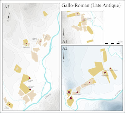
Figure 103: Overview of Gallo-Roman sites (Late Antique)
For the Roman period, geophysical survey proved to be of much more value than for the Iron Age. At Chantal, it added considerably to the detailed plan of the villa, while at Champs d'Arroux, an extensive stone-built establishment was discovered. At L'Haut des Champs, the results are less clear, but their extent is suggestive of another courtyard villa, while ill-defined traces of major buildings are apparent at a number of other locations, e.g. Le Grands Champ and Pâture de Rully. Not all of the sites found are necessarily residential. Those represented mainly by tile scatters, as at La Vente or Les Chaumes, may have had an agricultural function linked to nearby habitation, or be satellites of the larger sites at Chantal and Le Grands Champ respectively.
In other cases, the distinction may be chronological, but lie hidden behind incomparable data sets, as at Bas Cernat and Champs d'Arroux. A religious function is not be excluded for the latter site; it is bounded by boggy areas as well as the river, while at least one site with comparable three-cell buildings in northern Burgundy, at Asquins (Nouvel 2004), also beside a river, has the look of a sanctuary. The richness of the 19th-century discoveries made in the area around Pâture de Rully have led to the suggestion that it too might be a sanctuary (R. Niaux archive, CAE), although, like Chantal and L'Haut des Champs, it is set back on a terrace overlooking the river, in what would be a good location for a villa.
Given the small assemblages recovered, it is difficult to offer much by way of chronological precision for the duration of the Roman occupation at various sites. At Chantal, the diagnostic material recovered is predominantly 1st and 2nd century AD, but is almost all from one range and it would be surprising if the villa did not continue later. The sites in Area 2 do show evidence of longer occupation spans, but most of these also have much larger assemblages. At Le Grands Champ, the sequence potentially extends from the 1st century BC to the 4th-5th century AD. The samian is predominantly Central Gaulish, but there is also some South Gaulish ware and a single sherd of East Gaulish, products largely absent from other sites. Its, neighbour, Les Chaumes has no obviously early material and the diagnostic Roman sherds are all 2nd-3rd century AD, although there may be also some later activity here (below). At L'Haut des Champs, the date range is from at least the 1st century BC to the 3rd century AD, again with hints of some activity, but if so at a diminished scale. In Area 3, the main focus at Bas Cernat seems to be 1st to 2nd century AD, with some possibly 3rd-century forms, while one of two pottery scatters at La Bruyère includes 1st century AD material.
Allowing for the small size of the survey assemblage, the range of Roman wares represented is broadly as might be expected, apart from the notable absence of Terra Nigra and Terra Rubra or their close copies. TS is present at only four sites, and may be indicative of their status. It is mostly of Central Gaulish origin, although micaceous CG TS is only present in the largest assemblage, that from L'Haut des Champs. This site also yielded the widest range of post-conquest amphorae, including Baetican Dr 20 (present at two other sites), Tarraconensian Pascual 1 or Dressel 2-4, and Italian Dressel 2-4.
L'Haut des Champs also has the only two Gauloise amphora forms from the survey, one from the province of Narbonensis, the other from the Gueugnon kilns 40km down the Arroux (Olmer 1996). The Gueugnon kilns also produced terra sigillata, fine Rhenish type wares and a range of coarsewares (Notet 1986; Creuzenet 1996b). These products too were almost certainly reaching the Autun region, although no other Gueugnon wares have been specifically identified among the survey finds. Rebourg (1998) has suggested there may be river port facilities at Autun, and the Gueugnon products are likely to have been transported by river. Much of the pottery is likely to have been produced at Autun where kilns for coarsewares and flagons are known (Creuzenet 1996a).
For the areas prospected, the density of sites dating to the High Empire is around 10 per km², an extremely high figure. This is undoubtedly biased, however: first by the focus of Area 1 on the known villa at Chantal, second by aggregating sites of different type and date, and third due to a general avoidance of survey in the higher areas away from the river. Taking only sites which seem likely from their pottery assemblages and/or architectural characteristics to represent residential foci, the overall density falls to nearer five per km². This is still far higher than in other regions of good-quality agricultural land where systematic survey has taken place like the Aisne and Somme valleys, where ground conditions for fieldwalking were far more favourable (e.g. Haselgrove 1996). Our survey results therefore form a basis for suggesting that the best-quality agricultural land near Autun was indeed densely settled during the 1st to 3rd centuries AD, with the city attracting a higher density of villa settlement, comparable to the clustering reported around other major Roman cities in Gaul such as Bourges or Rennes (cf. Woolf 1998, 158).
One question which the survey data cannot begin to answer concerns whether there is any evidence of precocious Roman cultural expression on rural sites comparable to that seen on Mont Beuvray (cf. Paunier and Luginbühl 2004). The only point that can be made is the complete absence of Campanian ware and Italian sigillata and Gallo-Belgic wares and near-absence of SG samian at sites potentially occupied in the mid- to later 1st century BC. According to Tacitus, in AD 21 after their defeat in battle, Julius Sacrovir and his companions fled to what is variously translated as a house or villa near Autun (Annals III, 45). There they killed themselves and the building was set on fire - which could be taken to support the existence of élite rural establishments at this time, but might also hint that they were still being constructed traditionally, wholly in timber.
In contrast to the earlier part of the Roman period, the survey revealed little ceramic evidence for late Roman activity. Even the bigger site collections yielded only a handful of sherds in forms suggesting a 4th-century date, let alone any later. To judge from certain other regions, some of the undiagnostic greywares may also be of this date, but even so, clear evidence of late occupation is sparse compared with the previous period. As noted above, this may partly reflect those areas of the sites which were available to sample, and major establishments like the villa at Chantal may well continue, although perhaps with reduced material culture. Autun itself remained an important centre at this time (Rebourg 1998). Although the city was sacked during the troubles of the Gallic empire, its restoration was set in hand by Constantius Chlorus (Woolf 1998) and, when his son, Constantine, visited Autun in AD 311, the Scholae Maenianae had evidently recovered and were once again flourishing (MacKendrick 1987). It is during Constantine's reign that the first Bishop of Augustodunum is documented and there was a church on the site of the present cathedral by at least the 7th century. In the later 5th century, the civitas was absorbed into the expanding Burgundian kingdom, which in turn came under Merovingian hegemony in the 6th century (Berry 1987).
A lack of late pottery is by no means confined to Burgundy (e.g. Carreté et al. 1995) and is obviously one contributory factor in the reduction in rural site numbers and/or visibility that occurs in many parts of the Roman West in the late Empire (e.g. Millett 1992; Haselgrove and Scull 1992; Haselgrove 1990; 1996). The reduction in pottery is a phenomenon deserving of further exploration. As yet it is unclear whether there was a move away from consumption of ceramics - and if so whether this is due to lack of supply or lack of demand - to other forms of conspicuous display, such as investment in architecture (e.g. Woolf 1998, 148-68). In other provinces, élite dwellings were significantly elaborated in the 4th century, and there is no reason why this should not also be the case in the hinterland of Autun. With regard to the study area, there is little more that can be said without follow-up excavation.
Analysis of the survey pottery has, however, isolated a group of micaceous coarseware fabrics (B4), represented by some unusual forms paralleled (admittedly not very locally) in the 5th to 6th centuries AD. These B4 fabrics occur in small numbers in a number of mainly earlier site collections, but are above all a particular feature of the finds from three fields on and beneath the slopes of Beaufort, where they account for a strikingly high proportion (up to 80-90% by number) of the admittedly smaller assemblages from here. This grouping suggests a major settlement focus in the area in late antiquity, either near the current farm of Chevannes or even on top of Beaufort hill. In Area 3, there are hints of another less definite cluster of late sites at Le Champ Réau and Les Grands Quartiers, not far from the hamlet of Chazeu. Occupation or reoccupation of hilltop sites and increased nucleation are both widely attested elsewhere at this general period, so it would not be surprising if we were seeing similar processes at work in the Arroux valley.
For the remaining centuries of the first millennium AD, the survey is silent, no doubt partly on account of continued low levels of pottery use. Syagrius, Bishop of Autun in the later 6th century, is recorded as giving his villa at Laizy to the church (Le Bras 1938), but at this period villa had a range of meanings from rural residence to village (e.g. Wickham 2005, 510-11). As in other parts of France, it is likely that many present-day villages and hamlets in the area can trace their origins to at least the Carolingian period (cf. Popineau 2007; Wickham 2005). However, no plots on the edges of current villages could be walked, which might have permitted us to determine whether pottery of this date is present, and in any case nucleated settlements are likely to have co-existed with smaller farms (Berry 1987). The earliest surviving work in the church at Monthelon is 11th century, while the church at Laizy dates to the 12th century.
To our surprise, the survey did not yield any of the normally ubiquitous glazed and unglazed ceramics characteristic of the high Middle Ages. The lack of medieval pottery is interesting and may imply that much of the survey area was under pasture at this period, or that household refuse was not deposited on the fields as manure.
© Internet Archaeology/Author(s)
URL: http://intarch.ac.uk/journal/issue25/3/8.html
Last updated: Wed Oct 29 2008