PREVIOUS
NEXT
CONTENTS
HOME
4.1 Plough damage, sub-soiling and blown sands
During topsoil removal the machine depth was carefully monitored to leave the base of any plough-marks to be excavated by hand. The ploughsoil in all three trenches was a dark grey loamy sand, incorporating large amounts of recently introduced manure and straw. There was evidence in all three trenches of at least two phases of deeper ploughing and at least one phase of sub-soiling. In Areas 28AA (Fig. 12) and 28AC the bases of the plough furrows were cut into blown sand deposits; in Area 28AB there was a small area of shallow blown sand in the south-west corner of the trench, elsewhere the deeper plough furrows had cut into and truncated the archaeological deposits (Figs. 13 and 14).
We do not have a detailed understanding of the origins, mechanics or chronology of the blown sands in Heslerton. It appears that the sands first became mobile during the last glaciation, probably as a consequence of high winds sweeping across a frozen landscape with only elementary vegetation cover. Whatever the source and origin of this material, the blown sand is probably the most important characteristic of the archaeological landscape of Heslerton. The uniform red-ochre coloured blown sands have been observed in numerous locations extending over more than 20km along the southern edge of the Vale of Pickering, burying and protecting features showing a very broad date range. Major sand storms remain a characteristic during the late spring and autumn and it is clear that the formation processes, which have allowed these deposits to accumulate, are far from simple. When first identified on Heslerton Site 1, Cook's Quarry, it became clear that buried soils that appeared to represent a single deposit and were sealed by blown sands could range in date from the Neolithic to Late Iron Age within only a few metres of each other. The development process clearly combines phases both of erosion and deposition that in the past may have included shifting dune formations. For much of the area between the 28m and 40m contours the rate of deposition of blown sand has outstripped that of erosion, thereby enhancing the soil profile overall and protecting extensive areas of buried landscape.
Ploughing is the principal agency of destruction of archaeological deposits in Britain. Deep ploughing and ridging associated with the growing of potatoes, and the mechanical harvesting of potatoes and other root crops have, with the advent of ever larger agricultural machinery, caused a catastrophic rise in the scale and rate of destruction of rural archaeology in Britain during the last decade. In the case of the sandy lands that are characteristic of the Heslerton landscape, between the foot of the Wolds and the edge of the ancient wetlands, the damage is more devastating as the archaeological deposits covering extensive areas have been preserved beneath the layers of blown sand. The very sandy soils derived from the combination of blown sand and the well-drained soft sands and gravels beneath are characterised by poor agricultural potential and until recently were considered marginal at best and likely to produce very low yields except in very unusual years. Intensive root cropping is a recent innovation, aided by irrigation, without which the crop yields would be generally poor or, more often than not, fail completely. Sub-soiling, where deep winged tines as deep as a metre are dragged though the soil to break up mineral pans in the soil, is another farming practice that has been promoted by agricultural agencies. Excavation and observation in nearly 50 locations in the research area has revealed that the supposed mineral pans either do not exist or are so fragmentary in this environment that sub-soiling serves absolutely no useful purpose (J. Rackham pers. comm.). The impact of a sub-soiling plough on the archaeological deposits can be devastating, particularly in the case of structures with stone foundations. For those engaged in farming on the sand, the singular contribution of this process seems to have been to support the manufacturers and suppliers of the sub-soiling equipment and add unnecessary costs to farming the land for no additional return.
The three trenches opened on Site 28 allowed us to examine the nature and extent of the blown sands in three locations within the same field. Experience elsewhere within the Heslerton research area has demonstrated that the blown sand deposits are highly variable in thickness; even allowing for the increasing thickness of the deposits along field boundaries the depths within any field vary considerably and mask undulations in old land-surfaces completely. Work undertaken since the excavations on Site 28 has demonstrated that the thickness within a single field can vary from areas where the blown sand was completely absent to others where the thickness of the overburden exceeds five metres (Powlesland et al. 2006). Deep deposits have built up along the north-south field boundaries where sand has been trapped in the vegetation of the hedges, reflecting high soil mobility during the last century; perhaps a consequence of more intensive farming. The boundaries of the field identified as Site 28 have been recently altered, particularly on the eastern side, so while the trenches are located at the eastern edge of the field there are no exceptional deposits related to the current field boundary.
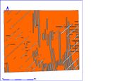
Figure 15: Area 028AA showing the three phases of deeper ploughing leaving plough-marks and the extent of blown sand.
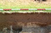
In Trench 028AA, blown sand survived covering the whole area of the trench, sealing all the archaeological features and cut by three phases of plough-marks (Fig. 15). The surviving plough-marks comprise a set of chisel-plough or sub-soiling cuts running north-east to south-west and cutting through an earlier phase of similar plough-marks aligned east-west. The narrow plough-marks cut through a group of roughly north-south conventional plough-marks that were up to 8cm deep, concentrated in the eastern half of the trench where they overlay and cut into the blown sand filling of a broad shallow feature, a possible trackway or broad medieval furrow, running north-south through the area. The survival of the plough-mark cuts within the area of the possible furrow may indicate that the furrow survived as a topographic feature when this phase of ploughing took place, since when the surface has been levelled with less invasive ploughing. The blown sand, which was removed in 3cm thick spits, was up to 15cm thick, merging with a mottled and darker buried soil deposit at its base. The survival of blown sands sealing buried soils and features unaffected by recent damage is reassuring; however, this is just one small area of a very large field.
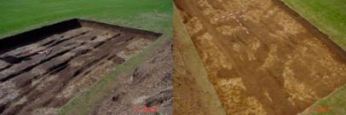
In Trench 028AB, very little blown sand survived; only a small patch in the south-west corner of the trench remained intact and even that was severely cut by plough-marks. There was clear evidence of relatively recent and deep plough-marks, possibly associated with potato cultivation and harvesting, throughout the area examined. These linear features vary in width and depth (up to 30cm wide and cut up to 10-15cm into the underlying deposits), and appear to have been more intrusive in the centre of the area where the ploughsoil was thinner than either the north or south ends. In the centre of the trench a large area of disturbance reflected damage from the plough cutting into a number of archaeological features. In contrast to the two other trenches this area had been devastated by ploughing (Fig. 16).
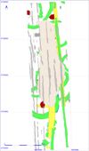
Figure 16: Plan showing plough-marks in Area 028AB.
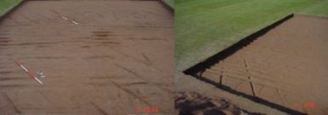
Following a massive rainstorm, which left Trenches 28AA and 28AB full of water, a series of chisel plough-marks cutting across the northern end of Area 28AB from west to east became clearly visible as a consequence of differential drying (Fig. 13).
PREVIOUS
NEXT
CONTENTS
HOME
© Internet Archaeology/Author(s)
URL: http://intarch.ac.uk/journal/issue27/2/4.1.html
Last updated: Wed Nov 11 2009