PREVIOUS
NEXT
CONTENTS
HOME
4.3.1.2 Discussion
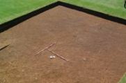
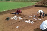
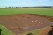
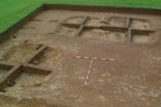
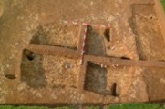
Excavation of Area 28AA confirmed that in this area blown sands, although cut by sub-soiling and other ploughing, remained mostly intact, preserving buried soils of an old land-surface at the base. The identification of intact buried soils containing Iron Age material and the small pit containing a deliberate deposit of middle Iron Age date indicates that occupation evidence from the middle of the Iron Age may be found within the ladder settlement to the north, or in closer proximity (but without any obvious features showing in the magnetic surveys). The excavation confirmed the identification of the large rectangular anomalies found through air-photography and geophysical survey as Grubenhäuser. Despite the lack of independent dating evidence or any securely datable material within the filled Grubenhäuser, the assemblage analysis indicates that although there are similarities in the fills between 028AA00023 and 028AA0024 it is unlikely that they stood at the same time. The assemblage in 028AA00022 was quite different in character and included evidence of iron-working in the form of slag and charcoal, not found in the other features.
The Early Anglo-Saxon or Anglian settlement identified through geophysical survey, of which the excavated Grubenhäuser were a part, included more than 200 Grubenhäuser covering an area slightly larger than, and at least contemporary in part with, the excavated settlement at West Heslerton 2.5km to the west. This demonstrates that the excavated site is not unique. It is one of a number of large, well-organised settlements established during the Early Anglo-Saxon period on the southern side of the Vale of Pickering. Geophysical surveys undertaken since the completion of the excavations on Site 28 have revealed a third large settlement example, mostly lying beneath the modern village of Sherburn 2km to the east, and a number of other smaller settlements represented by groups of 15-50 Grubenhäuser. The density and nature of the Early Anglo-Saxon settlement in the area has clearly been completely underestimated; moreover it seems unlikely that the density and scale of activity in the Vale of Pickering should be wildly different to that found elsewhere in Early Anglo-Saxon England, suggesting that we need to reassess the picture nationally (Powlesland et al. in prep).
PREVIOUS
NEXT
CONTENTS
HOME
© Internet Archaeology/Author(s)
URL: http://intarch.ac.uk/journal/issue27/2/4.3.1.2.html
Last updated: Wed Nov 11 2009