PREVIOUS
NEXT
CONTENTS
HOME
4.3.3 28AC
The third trench, measuring 1.6m x 35m, aligned north to south and situated 6m to the north of Area 28AB, was excavated to gain an insight into the level of preservation of the features that comprise the 'ladder settlement' and to gather dating evidence. The trench cut across only the southern third of the dense network of trackway and enclosure ditches that make up the ladder settlement (Fig. 11). There was a good correlation between the major east-west ditches revealed in the geophysical survey and those identified in the trench, despite the considerable depth of overburden, which at the northern end of the trench was nearly a metre deep.
The evidence for plough-damage and that relating to the blown sands is discussed above, the 3-D spatial analysis demonstrating that the blown sands incorporate structure not reflected in the visual appearance of what appears to be an amorphous deposit. The blown sand in this location has preserved the underlying archaeology, which is therefore not currently threatened by ploughing. The southern 25 metres of the trench included areas of buried soil at the base of the blown sand, which when removed revealed evidence of two 'barrowlets', one cut by a probable trackway ditch dating to the 4th century. This trackway ran along the southern side of the ladder settlement, the southern trackway ditch being interrupted as it passes the group of barrowlets examined in Area 28AC. This feature is linked to a network of ditches forming regular enclosures, which may relate to a major redefinition of the ladder settlement during the Late Roman period (Figs. 39 and 40).
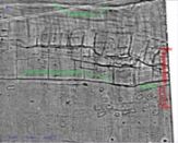
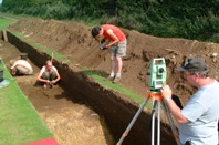
Figure 39: The location of Trenches 28AB and 28AC shown in relationship to the geophysical survey data, indicating the trackway and related regular enclosure network to the south of the main ladder settlement complex.
Figure 40: Work in progress in Trench 28AC, showing Tom Cromwell using the reflectorless total station and Keith May recording using a Handspring PALM PDA.
Although the trench cut across five ditches and a single smaller slot or gully, the narrow trench did not cut across enough intersections to allow us to establish their full stratigraphic sequence. The short excavated ditch segments were likewise too limited for the retrieval of sufficient material to establish the precise date range of each of the ditches. Sufficient pottery was recovered to demonstrate that these ditches reflected a process of enclosure construction and redefinition, which spanned the period from the 2nd to the 4th centuries AD. The presence of Late Iron Age ceramics in the blown sands and the odd sherd in the ditches indicate that there is likely to be Late Iron Age and probably Early Roman settlement focus nearby.
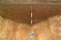
Figure 41: The west-facing section through ditch 028AC00055 after excavation. The blown sand shows clearly beneath the modern ploughsoil, while the grey gleyed soils filling the base of the ditch demonstrate that the base of the ditch had contained standing water as it filled in.
Before discussing the structural evidence, which survived in the northern part of the trench, an assessment of the ditches reveals details that help us develop a broader understanding of the ladder settlement and its environment. The most southerly of the ditches, 28AC00055 (Fig. 41), appears to define the northern boundary of a trackway, bounded on the south by what appears to be a slighter and interrupted ditch defining a trackway some 4-5 metres wide, judging from the geophysical survey. The full extent of the excavated ditch was 2.8m wide and slightly under lm deep; the evidence both in plan and in section indicated that the ditch had been re-cut or, probably more accurately, cleaned out on numerous occasions. The re-cuts indicate that the ditch in use was probably no more than 1.5m wide at the top, and that during the constant cleaning the ditch line had been moved to the south. The incorporation of large amounts of gravel in the fills against the northern side may indicate that the excavated material derived from the ditch had been used to establish a hedge bank on the northern side. An examination of the base of the ditch showed that there were two ditch butt-ends extending beyond the limits to the west and east; these may indicate that this section cut across a gang boundary where ditch segments dug by teams from each direction had met. The fills of this ditch contained more than 120 sherds of Late Roman pottery, including sherds of Crambeck, Huntcliff and Knapton Wares, indicating that the ditch must have been filled in during the late 3rd or 4th century. The network of enclosures, which appear from the geophysical survey to be contemporary, indicate a major re-planning of this part of the ladder settlement at this time. Gleyed sands in the basal fills indicate that the ditch probably held water at the time, and that its construction may be associated with a desire to increase drainage in this environment on the edge of the wetlands that then covered most of the base of the Vale of Pickering.
The ditch had cut away part of a probable 'barrowlet (028AC00088), and another measuring only 1.5m in diameter (028AC00064) (Fig. 42) was exposed a little further to the north. Although the presence of a bank is suggested by the gravelly fills on the northern side of the ditch and by the fact that during the frequent cleaning the ditch line moved to the south, there was no surviving evidence of such a bank.
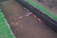
Figure 42: The filled ditch of 'barrowlet' 028AC00064 showing as a dark soil mark running into the eastern limit of excavation.
Nine metres to the north of 28AC00055 the trench cut across ditch 028AC00071, another ditch aligned east-west measuring 1.3m wide and 0.5m deep with a broad W-shaped profile, reflecting re-cutting once again with the latest cut on the southern side. The ceramic assemblage of about 50 small sherds from hand-made calcite-gritted fabrics indicates a probable 4th-century date. Just over a metre to the north a shallow gully (28AC00027) with a flattened V-shaped profile, 1.1m across and 0.2m deep and aligned or curving towards the north-west, contained a similar but smaller assemblage of calcite-gritted material.
028AC0049 was situated another 2.5m to the north of 028AC00027. This ditch or slot had a shallow V-shaped profile with a clearly defined steep-sided V-shaped cut in the base. In contrast to the ditches to the south, it showed no clear evidence of re-cutting and incorporated bands of grey silts that may represent stabilisation layers where turf formed in the layer above the primary fill. The ditch contained three distinguishable fills with only the upper fill, 028AC0003l, containing pottery. This deposit merged with the buried soil at the top of the ditch cut and no clear boundaries could be defined between the two. The ceramics were once again calcite-gritted wares and included no clearly diagnostic sherds that could confirm dating beyond Late Roman. The ditch had cut away part of a small pit or post-hole that extended beyond the western limit of excavation. Just to the north of this feature, 0.2m from ditch edge to edge, a broad feature 5.2m wide at the surface and 0.8m deep at the deepest point, comprised a frequently re-cut and redefined ditch with a complex profile reflecting the many different cuts or cleanings. Although in plan-form the feature appears as two ditches, it seems most likely that this was originally one ditch that once again appears to have been continuously re-cut on the southern side. The latest clearly defined cut, on the southern side, represented a ditch only 1m wide and 0.8m deep. A broad shallow scoop appears to have truncated the ditch deposits of the northern side and filled with material indistinguishable from the buried soils. This deposit may have formed in an area where the upper fills of the various cuts had been eroded by human and animal traffic rather than a result of a deliberate cut; a gravel ridge separating this deposit may be remaining upcast from the excavation of the final phase ditch. The ceramic assemblage is dominated by Late Roman calcite-gritted wares; a possibly Anglian sherd may indicate that the last phase of the ditch at least remained open until the Post-Roman period. A small possible fence slot 1m to the north appears to respect the alignment of this feature and cuts through the most northerly ditch in the series, 028AC001000.
Ditch 028AC00100, which was aligned north-east to south-west, had a broad V-shaped profile and was 1m deep and no more than 1.5m wide, the southern side of which had been partly cut away by the latest re-cut, which created a broad, nearly 2m wide, shallow feature only c. 0.25m deep. The small ceramic assemblage from this feature was without any diagnostic sherds. All were classified as Romano-British, were hand-made in local calcite-gritted fabrics and could be dated anywhere between the 2nd and 4th centuries.
To the north of ditch 028AC00100 the trench intersected the western side of a ring-gully, with an estimated diameter of 7-8m; this feature appears to be part of a round-house, with much of the interior area exposed within the trench covered with chalk rubble (Figs. 43, 44). The rubble deposit may relate to a construction platform or be derived from the destruction of a building. A group of stone-packed post-holes within the southern part of the exposed ring may relate to the round-house; however, the exposed area was too limited to say this with any confidence. Quantities of chalk rubble in the filled ring-ditch could either indicate that the ring-gully had been cut through the rubble, some of which tumbled back into the gully, or that the two relate to the same structure. To the north of the probable round-house a 0.25m thick deposit of buried soils containing sherds indicating a 2nd-century date and incorporating layers of pea-gravel may once have served as an earth floor. Whatever the role of this deposit, its presence demonstrates, in this location at least, the good preservation of domestic deposits with associated structural remains in the 'ladder settlement'.
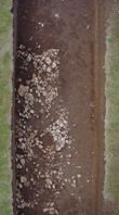
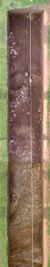
Figure 43: The stone setting within the northern end of Trench 28AC and the partially excavated ring-gully during excavation.
Figure 44: Rectified photo-mosaic combining multiple vertical frames to give a high-resolution plan view of the northern twelve metres of 28AC.
PREVIOUS
NEXT
CONTENTS
HOME
© Internet Archaeology/Author(s)
URL: http://intarch.ac.uk/journal/issue27/2/4.3.3.html
Last updated: Wed Nov 11 2009