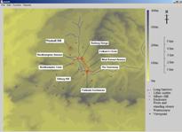
Figure 1: The Avebury area.
The Avebury area is a World Heritage Site. After Stonehenge it is the best known and most important Neolithic ceremonial centre in Britain. In the earlier Neolithic it was the only location where numbers of both megalithic and non-megalithic long barrows were found in close proximity, thus demonstrating the uniqueness, and possibly the importance, of the region. Several of these barrows, such as West Kennet, are still well preserved. Also located in the area are three causewayed enclosures, the best known being Windmill Hill: a typesite for early Neolithic study. The later Neolithic saw the building of prehistoric Britain's largest henge and stone circles (Avebury itself), longest stone-lined avenues (West Kennet and Beckhampton Avenues) and largest man-made mound (Silbury Hill). It is not just the size of these monuments that make the area special but, also, their close proximity and the relationships between them, as will be demonstrated.
The area of study (Fig. 1) is located around the upper Kennet Valley of the Marlborough Downs in Wiltshire. It sits in a promontory of chalk land with the high chalk of the Marlborough Downs to the south and east; beyond that, further to the south, is the Vale of Pewsey and then Salisbury Plain. To the north and the west the land slopes away gently to the Avon and Thames valleys. The Avebury area is rich in good-quality flint, an important resource for early inhabitants, but apart from the Kennet River there is little natural surface water in the area, possibly explaining the low levels of Mesolithic activity. Another notable natural resource is the abundance of sarsen stone or greywethers that may be found on the land surfaces of many of the valleys to the east of Avebury. The nature of the terrain itself is that of rolling hills, with the height above sea level varying between around 150m OD in the valleys to around 300m OD for the higher hills.
Figure 1: The Avebury area.
The area has been the subject of antiquarian and archaeological attention since the time of William Stukeley (1743) and continues to be at the forefront of current Neolithic study (e.g. Pollard and Reynolds 2002; Gillings et al. 2008). Yet the question still remains: were these monuments part of a unified ceremonial complex, and if so how do they relate to each other and what might these relationships say about the people that dwelt there over four thousand years ago? Many of the monuments have been damaged or destroyed and the landscape has changed dramatically since the Neolithic, making it difficult to get at these relationships. This article seeks to recreate the past landscape, and thus the relationships within it, using digital modelling so that it might be studied using a phenomenological approach (Tilley 1994). It uses Parker Pearson and Ramilisonina's (1998) interpretation of a journey across the Avebury landscape as a point of departure. Furthermore it is hoped that this article will also demonstrate the potential for the use of digital modelling as a highly interpretative tool rather than merely to aid presentation, as is often the case.
© Internet Archaeology/Author(s)
URL: http://intarch.ac.uk/journal/issue27/3/1.html
Last updated: Tues Oct 27 2009