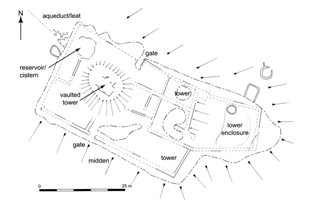
Figure 3: Plan of WF1415 (Barker et al. 2007, 319).
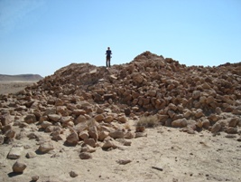
Figure 4: Photo of remains of WF1415, facing south (photo Hannah Friedman).
The Wadi Ratiye is a tributary of the Wadi Faynan located c. 3km north-east from Khirbet Faynan (see Fig. 2). Small and relatively narrow, the Wadi Ratiye deeply incises the Jabal Khalid Mountains, the wadi bed being low and relatively flat whereas the rest of the terrain is a steep, rocky, mountainous area. Thus, the Wadi Ratiye forms a corridor between the mountains while travel outside the wadi is very difficult. This landscape is a closed system and acts as a naturally imprisoning space.
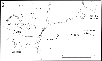
Located up this wadi are the remains of a large building and a number of surrounding settlements close to an extensive suite of mining features. The main complex, known as Khirbet Ratiye (WF1415; see Figs. 3 and 4), was one of the largest and most physically imposing buildings in the Faynan region. This was a high-status site with plastered walls, and finds including hypocaust tiles and glass. Hypocaust/flue tiles suggest the inclusion of a heated structure. A reservoir fed by an aqueduct was located in the north-west corner of WF1415 and this was the main source of water for the community (Barker et al. 2007, 321). A wall surrounds the building, measuring 42x25m, with two possible entrances on the north and south walls. On the east side of the wall there is evidence for two towers both facing towards the blind valley, or Qalb, where the copper mines were located. The west side of this building faces a slope, which makes this section particularly vulnerable, but no towers were placed here. This suggests that, despite the defensive appearance of the complex, protection was not the primary purpose of the building.
Satellite communities surround this main site, such as WF1446 to the south (a grouping of 14 one-room structures). Similarly, WF1518 to the north has boulder-constructed rectangular structures of a slightly more complicated nature, containing up to three rooms. Two further settlements are located to the east of the main site, WF1516 and WF1515 (Figs. 5 and 6).
A small field system, WF1519, with three terraces is found near these hamlets along the wadi edge. Although WF1519 may have provided an important supplement to the diet of the inhabitants, it would not have been able to feed the entire community. Instead, all the sites in this wadi would have been dependent on supplies coming from outside sources and trade funnelled through the main settlement of Khirbet Faynan to the south.
The high-status buildings and finds suggest the presence of administrative officials located at WF1415 to oversee the ore extraction. It is likely this structure was the mining administrative site for the Wadi Ratiye and Wadi Abyad to the north, where the bulk of Roman and Byzantine mines were located. The settlements and hamlets located in this wadi were probably housing for miners (Barker and Mattingly 2007, 112).
WF1415 was not a control point physically limiting or monitoring access to the Ratiye. If that were the case then it could have been placed at the wadi mouth to prevent entrance or exit. Instead, it was located across from the Qalb Ratiye and its mines. The towers strongly suggest that one of its uses was as a viewing platform, but what were the possible effects or benefits of observation? In order to explore this we first need to model what could be seen from the towers.
© Internet Archaeology/Author(s)
URL: http://intarch.ac.uk/journal/issue27/4/3.html
Last updated: Tue Nov 3 2009