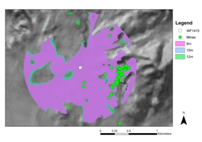
Figure 11: Overlay of viewsheds created with differing heights 8m, 10m, and 12m.
The viewsheds from the towers of WF1415 indicate its suitability as an observation structure. Although there are some differences depending on tower height, these are not substantial (Fig. 11).
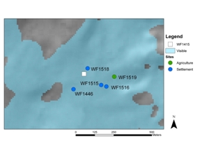
There are three key areas that are visible in all of the viewsheds. First, the surrounding settlements are within view of the tower, including the cluster of modest, one-room structures, the likely housing for workers (Fig. 12). The main authorities in WF1415 would have been able to monitor the housing of the community as well as large gatherings, thereby lessening a miner's or convict's ability to act independently even when not at work.
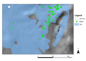
The mines form the second key area of the landscape, all of which fall within the 1km 'near distance' limit established for identifying objects from the towers. While there would be days (and nights) when visual observation would not be possible, the overwhelming majority of the entrances to the mines would be observable from the towers. If the model is set with WF1415's towers at a height of 8m, 55 out of 59 of the entrances are visible. This number increases (57 out of 59) at 10m and 12m heights. Finally, most of the landscape of the Qalb, and by extension anyone moving within those areas, would be observable (Fig. 13).
All of these key points in the landscape – housing, mines and the intervening areas – are within the 1km limit. Within this viewshed it could be expected that under most conditions a human's general actions would be identifiable. If there were problems of discipline or unproductive behaviour these could be observed.
The Wadis Ratiye, Abyad and Khalid form a triangle where the bulk of the mines exploited in the Roman and Byzantine period were located. These wadis create a traversable path. WF1415 is an observation structure ideally placed to monitor a wide portion of the landscape, including these routes out of the region (Fig. 14). From the observation point of WF1415 it would be possible to conduct surveillance of the exits to and from the Qalb and Wadi Ratiye.
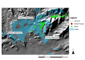
The Wadi Ratiye's exit south to the central Wadi Faynan could be monitored. The north exit that leads into the Wadi Abyad was also covered. Also visible from this tower is the pathway out of the wadi triangle through the Wadi Khalid, although this only possible at a 'middle distance,' 2km and 4km. While the observation position from WF1415 provides a less detailed view of this exit than the others, monitoring this exit would be complemented by the close proximity of Khirbet Faynan. The Wadi Khalid exits into the heart of the Roman and Byzantine settlement during this period; it is not likely that individuals leaving this wadi were unnoticed (Fig. 14).
The placement of WF1415 allows for comprehensive views, indicating that it was purposefully placed in the landscape. From the main administrative structure the surrounding settlements, industrial areas, general landscape, and exits could be monitored. The workers, free or slave, knew there was a possibility that they were being watched, and this would have encouraged discipline. Discipline would have been reinforced if the observation of misbehaviour led to punishments (see section 7.2).
© Internet Archaeology/Author(s)
URL: http://intarch.ac.uk/journal/issue27/4/5.1.html
Last updated: Tue Nov 3 2009