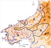
Map 8: Map showing the zones mentioned in the text.
It is not intended to attempt an in-depth analysis of the results of the survey, as this article is primarily intended as a summary presentation of data. Some useful comments can, nonetheless, be made. As a result of the information gathered on defended settlements, trends in the social, economic and ritual practices of the Iron Age in southwest Wales are beginning to emerge, as is the important contribution made by geographical and environmental factors. It is also evident that the information is a reflection, to some degree, of areas of particular archaeological study and discovery.
On the basis of the survey data it is now possible to postulate several zones of defended settlement in southwest Wales (Map 8); a rather more sophisticated division than that proposed by Williams in 1988. A lowland zone, A, spreading across most of central and south Pembrokeshire and western Carmarthenshire is dominated by small defended enclosures, many of which have concentric annexes. This is now a rich pastoral region, but with an increasingly stronger arable element to the west. Excavation on a limited number of these sites has demonstrated that this mixed farming economy was also a feature of the later prehistoric period in this area. It has been argued (Williams 1988) that the large number of small sites reflects a less hierarchical society than in areas dominated by larger hillforts. Chronologically, based on limited evidence, it would seem that these small sites were constructed during the last centuries of the first millennium BC and that they may indicate a high point in population numbers. Prior to construction of these small defended enclosures, Iron Age settlement would have been dominated by a less dense distribution of promontory forts. Clearly this has economic and social implications that have not yet been addressed.
Zone B, the Pembrokeshire coast, is an area of coastal promontory forts. Limited, but nevertheless conclusive, results from excavation indicate an early Iron Age, and possibly earlier, origin for these forts. If promontory forts are early Iron Age and small defended enclosures later Iron Age then definition of this zone is even more striking than that shown on the various maps, which have no chronological factoring. Although excavation has demonstrated that these coastal forts seem to have functioned in the same way as other defended sites in southwest Wales (Crane forthcoming), in so much as they contain similar suites of buildings and artefacts, their position on the interface of land and sea has led many authorities (for instance Cunliffe 2004) to suggest they had a symbolic role, a suggestion that is strengthened by their often unnecessary (to modern eyes) massive defences. Their distribution and size along the Pembrokeshire coast separates them from inland sites, again supporting their different or additional symbolic role over other forms of site.
Southeast Ceredigion (Zone C) is in many ways similar to central Pembrokeshire/west Carmarthenshire (Zone A), but there are differences. For instance, there are few promontory forts and hillforts here, and therefore the settlement pattern that preceded that of small defended enclosures is virtually unknown. Second, as noted above, there is an unusually high proportion of rectangular enclosures that could well represent a distinct cultural group.
Zone D comprises the Tywi valley in Carmarthenshire and is dominated by hillforts and larger defended enclosures. Concentric annexes are absent and there are few rectangular-shaped sites. These large sites are traditionally interpreted as indicating a structured, hierarchical society (Williams 1988, 32). Their location, with easy access onto what is now marginal upland, has been taken to indicate a mainly pastoral agricultural economy. Owing to an absence of even medium-scale excavation it is difficult to argue against these interpretations. Zone E, centred on the Teifi valley in Ceredigion, is similar in many respects to Zone D.
A wide range of site types and sizes is represented in Zone F, northern Ceredigion. These almost certainly represent a wide chronological range. Toby Driver (2005) has argued that architectural detail on some of these sites is in the tradition of forts to the east, suggesting strong connections with peoples in the Severn valley and the Welsh Marches rather than with groups along the Atlantic seaboard to the southwest and northwest. Certainly this is the only zone in which forts are located in a truly upland location — over 250m above sea level, with surrounding land that is now open moorland. Compared to elsewhere in southwest Wales Zone F has a greater proportion of sites in good defensive locations. This can partly be explained by topography, but chronology has an influence, as do the architectural influences mentioned above.
The last zone, G, which is mostly upland, contains virtually no defended settlements and indeed, apart from the Preseli Mountains in Pembrokeshire and the Black Mountain in Carmarthenshire, very few prehistoric settlements at all. Traditionally, this zone in the Iron Age has been viewed as suitable for rough grazing with no habitations. A recent discovery of an unenclosed settlement during pipeline construction high on Mynydd Myddfai in Carmarthenshire (N. Fairburn pers. comm.) may force a reinterpretation of this view. However, prehistoric settlement in this environment is in normal circumstances archaeologically difficult to detect.
© Internet Archaeology/Author(s) URL: http://intarch.ac.uk/journal/issue28/1/4.html
Last updated: Mon Dec 14 2009