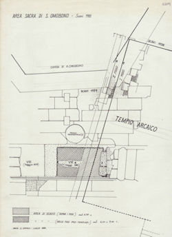
Figure 59: Plan showing the location of the sounding in settore VIII (AFSRCM, S. Omobono, b. 28, 1, c. 3028).
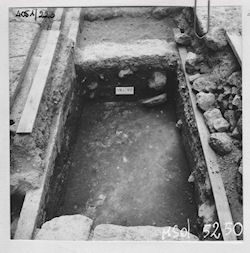
Figure 60: Settore VIII during the excavation (AFSRCM, S. Omobono, b. 31, 5, c. 4051.223).
The excavation of this trench, located between the foundations of the two frontal columns of the eastern temple (Figure 34), was begun on 8 July 1976 and ceased a few days later, and was only resumed on 7 July 1981 (AFSRCM, S. Omobono, b. 31, 5, cc. 4051.119, 121, 125, 127, 131, 137 e 239-253). Subsequently, work resumed on two occasions, the most recent of which involved the excavation of the deepest layers. The trench was progressively expanded from west to east, with the resulting sections designated VIII, VIIIA, and VIIIB (for a total surface dimension of 5.50 x 2.20m).
During the first part of the work, in 1976, the first layers were excavated, bringing to light a ferruginous layer composed of a core of tufo fragments around 10cm thick, located at a depth of 65cm from the slabs of the pavement. Beneath this layer, designated 1, were layer 2, composed of fine soil, and layer 3, brown in colour and containing abundant organic material. On 13 July, the spoil from layer 3 was sifted and the stratigraphy was analysed in section (the analysis of the stratigraphy continued on 15 July). On 20 July it was recorded that a beaten-earth surface was found lower down. A schematic section showing the stratigraphy is included in the notes, though it does not employ the same layer designations as the original notes; the third layer is in fact labelled as battuto (beaten-earth surface) (AFSRCM, S. Omobono, b. 31, 5, c. 4051.114; on the same page is a schematic plan labelled settore VIII; AFSRCM, S. Omobono, b. 31, 5, c. 4051.113).
Figure 59: Plan showing the location of the sounding in settore VIII (AFSRCM, S. Omobono, b. 28, 1, c. 3028).
Figure 60: Settore VIII during the excavation (AFSRCM, S. Omobono, b. 31, 5, c. 4051.223).
In the second phase of the work, carried out in 1981, the new extension of the trench was designated VIIIA (Figs 59 and 60). The excavation area was delimited by a tufo drainage duct to the south, while the northern limit was set just short of a medieval well in order to avoid contaminations of the stratigraphy. Probably at the behest of Ioppolo, a different system from that employed in the earlier work was used for this phase of the excavation in order to understand the stratigraphy more systematically; the excavation diary reads as follows:
'Questo metodo .. prevede che (secondo le indicazioni di metodo del prof. Ioppolo) non si debba procedere allo scavo dello strato sottostante se prima non si ben individuata la natura dello strato scavato e le sue relazioni con le strutture architettoniche con le quali connesso.' 'According to this method [...] (following the methodological instructions of Prof. Ioppolo) lower layers should not be excavated until the character of the layer above and its relationships to the architectural structures with which it is connected have been clearly determined.'
In this sounding, one or two letters were placed before the layer number to indicate the character of the deposit (the adopted codes are ST for archaeologically sterile layers; RP for fills; CR for layers of collapse; INC for debris from fire; DN for natural deposits; DA for artificial deposits; AFSRCM, S. Omobono, b. 31, 5, c. 4051.264; this system was already descibed earlier in the excavation diary, though R rather than RP was used for fills; AFSRCM, S. Omobono, b. 31, 5, c. 4051.241). The superficial layer of VIIIA was composed of loose soil with fragments of glazed pottery, maiolica, Campanian black gloss, building materials, etc. Layer R1, composed of clayey soil with fragments of Grotta Oscura tufo, travertine, medieval pottery, and impasto, was then excavated. In the southern portion, a distinction was made between R1s (superficial) and R1(1) in order to prevent contamination from the above layer. Below this layer were DA2(3), a beaten-earth surface of fragments of tufo rosso, and DA1(2), a heterogeneous clayey layer almost devoid of materials. Within layer DA(2), interpreted as a beaten-earth surface, was a round pit filled with yellow clay, situated near the centre of the trench. The excavators decided to half-section the pit, proceeding first with the excavation of the northern half. Layer DA2(3), the first to be excavated, was found to be characterised by fragments of Fidene tufo and peperino, the latter quite small. This was followed by DA3(4), composed of clay with numerous peperino and cappellaccio inclusions, and then R2(5), which was found to contain pottery, bones, and pebbles. In the southern part of the trench, layers DA1, DA2, DA3, and R2 were cut by the foundation trench of the drainage duct, which consisted of a U-shaped block of Monteverde tufo resting on a cappellaccio slab. The fill of the foundation trench contained sherds of impasto, bucchero, painted Etruscan finewares, and red slip pottery. A sketch and a section were included in the notes to illustrate the stratigraphy (Figure 61; AFSRCM, S. Omobono, b. 31, 5, c. 4051.250 e 252).
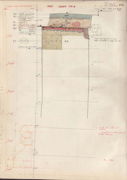
Figure 61: Stratigraphic section of the western wall of the sounding in settore VIII (AFSRCM, S. Omobono, b. 31, 5, c. 4051.252).
The work then proceeded with the removal of layer R2(5), characterised by pebbles, fragments of tufo rosso, and peperino. On 20 July 1981, the excavation was halted, and the trench was subsequently covered with tar paper to prevent contamination.
One of the pages of the 1983 excavation diary is titled '1983 Soundings Sector VIII pozzo medievale' (AFSRCM, S. Omobono, b. 31, 5, c. 4051.259). On 27 September 1983, area VIIIB was cleaned and a single sherd recovered from layer D2/6; the fragment, which was drawn in the notes, was included within
'battuto in pozzolana e tufo rosso-bruno che conclude i riporti per linnalzamento del piano dei templi (fine VI sec. a.C.?)' (AFSRCM, S. Omobono, b. 31, 5, c. 4051.261) 'a beaten-earth surface of pozzolana and reddish-brown tufo that capped the fills to raise the level of the temples (end of 6th century BCE?)'
Finally, some work was carried out in VIIIB in 1985. The trench was cleaned beginning on 17 June and the excavation continued until 15 July, although artefact processing and the documentation of the sections proceeded until 30 July (AFSRCM, S. Omobono, b. 31, 5, c. 4051.263-279). The depth at the start of this phase of the work, which had been reached in previous seasons, was 11.52m, as can be gleaned from a schematic section (AFSRCM, S. Omobono, b. 31, 5, c. 4051.263). The excavation diary records that:
'nell'ambito di ogni strato viene adottata una sottodefinizione al fine di distinguere le varie lenti costituenti lo strato stesso. Ex. RP2/02 = riporto 2, sabbioso terroso' (AFSRCM, S. Omobono, b. 31, 5, c. 4051.264) 'for every layer, a subdefinition is supplied in order to distinguish the various lenses that make up the layer. For example, RP2/02 = fill 2, silty sand' '
This is an important element for understanding the excavation methodology employed.
First, the trench was cleaned and stray materials recovered. On 24 June, layer RP2/02 was excavated and the trench was divided in two halves, only the eastern one of which was excavated. On the northern side, layer RP2/03 was distinguished on the basis of colour and consistency. Below it, layer RP2/02 came to light again. The excavators recorded the presence of a lump of sand with many river pebbles and fragments of cappellaccio in the north-eastern corner, designated RP2/04, which extended beyond the excavation limit. Blocks of tufo rosso were removed and layer R2/02 was excavated. A new layer, RP2/05, was identified, though RP2/03 was still present in the southern half of the trench. Additional blocks of tufo rosso, partly within the section, were removed. Layer RP2/06, a layer of silty sand, was identified, and RP2/07, composed of clayey soil, was excavated. Work then continued with the excavation of RP2/08, made up of silt, gravel, and small clay inclusions; fragments of impasto, tiles, bones, and charcoal were recovered. At this level (10.075m asl) the ground was very moist.
Despite Colini's methodological directives, the documentation of this trench is undermined by the fact that the excavation was carried out intermittently over a long period of time, with a resulting lack of clarity concerning the sequence of the work and the naming of the excavation unit itself; the fact that the trench was extended more than once well after the beginning of the excavation is also problematic. Overall, it is clear that Colini's instructions were not properly followed.
With regard to the stratigraphy excavated in 1981, it is possible to interpret layer R1 as a fill to raise the level for the construction of the southern stylobate in blocks of Grotta Oscura tufo, or, more likely, as a later layer. Layer DA1, identified in the text of the excavation diary as a clayey layer and in the section as a sandy layer, may be interpreted as a level for the construction of a pavement of slabs. Below it, layer DA2(a, b), can be understood as a loose stone foundation covered by a beaten-earth surface, also connected to the construction of the slab pavement. These layers were cut by a pit for the construction of the drainage duct; these elements may form part of the same construction phase (the drainage duct is the same as those identified in sectors V and VI, though it is difficult to be sure given the available data). Alternatively, DA1 and 2 may belong to an earlier phase than the drainage duct. Finally, layer R2 should be seen as a fill to raise the level of the podium.
The 1985 excavation was simply a continuation of the earlier work, so that layer RP2 is equivalent to layer R2 from the 1981 excavation. Nevertheless, a certain degree of ambiguity is introduced by the addition of a second number to the layer designations, which, according to the excavators, was intended to distinguish between the various lenses in each layer. Such lenses should rather be understood as distinct layers, though probably connected to a single construction effort to raise the level of the podium; this is evidenced, for instance, by the presence of a very substantial layer of tufo fragments (RP2/03) connected to the destruction of one or more structures, or by RP 2/04, a mixed layer with abundant gravel and river pebbles. Some layers were probably excavated simultaneously and not in the correct stratigraphic sequence (e.g. RP02, 03, 05). The only published section does not include the numerical designations of layers, which are instead characterised graphically; at the moment, this section does not add anything to the evidence from the excavation notes (Pisani Sartorio et al. 1989, table 2).
The presence of baulks that were excavated over time generates a number of problems, first among them the possibility of contamination and confusion concerning stratigraphical relationships. The excavation diary presents confused and contradictory evidence for this trench; even the different components of the excavation work are not clearly explained, engendering substantial doubt about whether the stratigraphic method was employed correctly. It is therefore important to investigate the area more systematically (the trench was not backfilled after the last excavation, permitting a reanalysis of the stratigraphy and the excavated materials in the course of any new fieldwork at the site).
© Internet Archaeology/Author(s)
University of York legal statements | Terms and Conditions
| File last updated: Mon Mar 12 2012