Figure 6: Rubber sheeting of images in Amuq Valley, Turkey. While these simple methods work over small areas, they are extremely time consuming, produce large errors in many areas, and destroy stereo capabilities of the imagery
Figure 6: Rubber sheeting of images in Amuq Valley, Turkey. While these simple methods work over small areas, they are extremely time consuming, produce large errors in many areas, and destroy stereo capabilities of the imagery
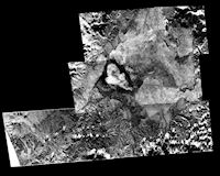
Until now, most researchers who attempted to correct the spatial distortions contained in CORONA imagery, a process termed 'rectification', have relied on fairly simple methods that are standard on many image-based GIS software packages, but which are not designed to deal with highly distorted and irregular images like CORONA. In general, researchers clip a small segment of the long panoramic image, and then the segment is stretched to match another map or satellite image by selecting a series of ground control points (GCPs) visible on both images. This process, termed 'rubber-sheeting', represents a coarse, algebraic generalisation of the imaging process and does not take into account the differential distorting effects caused by the terrain or the imaging geometry. Rubber-sheeting is also extremely time consuming because each small image segment must be individually rectified using a large number of GCPs and then stitched together to produce a larger map. The seams along the edges of images rarely correspond when stitched together and there are inevitably large spatial distortions within individual scenes. Previous efforts by Casana (2003) and other researchers using these methods to rectify KH-4B CORONA imagery resulted in errors of 100m or more on flat terrain, with significantly larger errors in mountainous regions (Figure 6).
© Internet Archaeology/Author(s)
University of York legal statements | Terms and Conditions
| File last updated: Fri Sept 21 2012