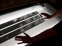
Figure 3: CORONA film strips on light table. These raw images contain extreme spatial distortions
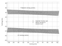
Figure 4: Diagram of spatial distortion in forward and aft cameras of a KH-4B CORONA satellite
Figure 3: CORONA film strips on light table. These raw images contain extreme spatial distortions
Figure 4: Diagram of spatial distortion in forward and aft cameras of a KH-4B CORONA satellite
Much of our work on the CORONA Atlas Project has been dedicated to developing new, more efficient methods to correct the spatial distortions found within raw CORONA imagery. CORONA images were taken by a panoramic camera on elongated film strips, a system developed to maximise both the area that could be covered in a single frame and the resolution of the final image (Figure 3). In the highest resolution CORONA images, produced by the KH-4B generation of satellites in operation from 1967–72, the area covered by each film strip is approximately 13.8 x 188km, but the imaging geometry of the camera and the surface of the earth result in a 'bow tie' area of the ground being stretched into the rectangular area of the film (Figure 4). Furthermore, the image motion compensators built into the imaging system did not fully account for the satellites motion during the image scan, which creates an 'S' shaped pattern of distortion from one side of the image to the other. A third source of image distortion is derived from the topography of the ground as the parallax changes between the ground and the imaging surface inside the camera. In an attempt to capture three-dimensional, stereo imagery, the satellite was also equipped with two cameras, one facing forward and another facing rear, or aft, such that the distortion found in these two cameras are opposite one another. These characteristics result in severe spatial distortions that radically alter the shape and size of individual features, as in the case of Zincirli Hoyuk in southern Turkey (Figure 5). This Iron Age fortified site possesses a nearly perfectly circular wall enclosing an area of around 40 hectares, but in uncorrected CORONA imagery it appears as an oblong oval, distorted in opposite directions on forward and aft cameras.
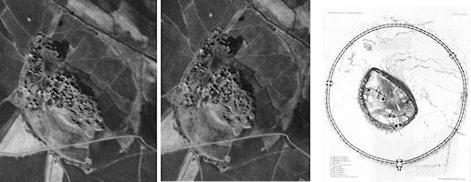
Figure 5: Zincirli Hoyuk, Turkey, as it appears in uncorrected images of forward and aft cameras, compared to a map of the site
© Internet Archaeology/Author(s)
University of York legal statements | Terms and Conditions
| File last updated: Fri Sept 21 2012