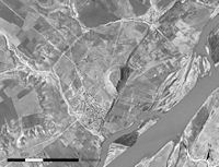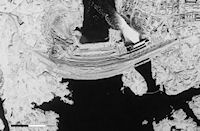
Figure 18: Ancient city of Samsat, submerged by the Ataturk dam project [CORONA atlas]
One of the changes that has resulted in most devastation to the archaeological record is the construction of dams and reservoirs throughout the Near East. River valleys, particularly in arid regions of the world, are highly desirable places for settlement, ancient and modern, providing easy access to water, cultivable farmland, plant and animal resources, and transportation. For these reasons archaeological sites are often densely concentrated along river valleys, and so the construction of reservoirs has a disproportionate impact on the archaeological record. Moreover, it is not only sites and features that lie within the zone flooded by reservoirs that are affected. The creation of huge water stores generally results in a significant increase in irrigated agriculture in surrounding areas, and these changes result in reduced visibility of sites and features as well as their outright destruction. In consequence, the transformation of agricultural regimes caused by dam projects can damage the archaeological record far from the inundated valleys.
Figure 16: Tabqa Dam and Lake Assad, Euphrates River, Syria [Static images | CORONA atlas]
The dam projects along the Euphrates River Valley in Syria and Turkey are particularly compelling cases in which archaeological sites and features have been affected en masse. Unlike the lower reaches of the Euphrates River valley where the hydrology of the basin encourages frequent avulsions of the river channel and even leads to an anastomosing series of channels, the river is deeply incised into a Pleistocene terrace in Syria, resulting in a channel that is tightly constrained in a narrow valley (Wilkinson 2003). The arid steppe through which the river flows has long encouraged settlement nearby, producing a rich archaeological record along this narrow band of green.
As early as 1927, when Syria was controlled by the French mandate authority, plans were laid for the construction of a dam in order to conserve water resources and make irrigation possible in the otherwise semi-arid lands surrounding the Euphrates River. With support from the Soviet Union, construction of a dam located near the town of Tabqa began in 1968 and was completed in 1973 (Lupu 2002). The reservoir created by the dam, now known as Lake Assad, was ultimately intended to irrigate 640,000 hectares of land, although a variety of problems have prevented a realisation of that goal. Today, only around 150,000 hectares are irrigated by the dam, and it produces only about 20%of its expected electricity, although Lake Assad does provide the city of Aleppo with most of its water. While the full benefits of the dam project have yet to be realised, the reservoir has had a severe impact on archaeological sites. As soon as the dam project was planned, a major rescue effort by archaeologists from around the world was undertaken in the region that would be flooded. With funding from UNESCO, 20 archaeological sites were excavated in the late 1960s and early 1970s and a regional survey of the valley was undertaken (Freedman 1979). Discoveries ranging from the earliest evidence of domesticated agriculture at Abu Hureyra to the spectacular finds of Uruk colony sites at Jebel Aruda, Sheikh Hassan and Habuba Kabira reorientated research directions of Near Eastern archaeologists for a generation, but today most of these remarkable sites and the landscapes of which they were a part are submerged below the waters of Lake Assad.
CORONA satellite imagery of the region provides a truly remarkable opportunity to explore the valley as it existed prior to construction of the Tabqa Dam. Figure 16 compares a CORONA image from November 1968 with a Quickbird satellite image from 2010, available via Google Maps (also see CORONA in 3D). While sedimentation and meandering of the Euphrates channel have likely destroyed or obscured many archaeological sites on the river floodplain, some areas form islands of preserved landscapes.
Figure 17: Ataturk Dam, Euphrates River, central Turkey [Static images | CORONA atlas]
The Ataturk Dam on the Euphrates River in Turkey, one of the largest dams in the world, was constructed between 1985–1990 with the aim of providing both hydroelectric power and a large, reliable source of irrigation water. It, along with numerous smaller dams in the region, now produce a large supply of electricity and offer irrigation water to a vast area of central Turkey. The dam project has created sharp political controversies as it now restricts the flow of the Euphrates by as much as a third according to some estimates, while the initial filling of the reservoir caused the flow of the Euphrates to cease completely for a month in 1990 (Shapland 1997). In addition, more than 50,000 local residents were forced to relocate from areas that would be inundated.
Like any major dam project in the Middle East, the Ataturk Dam inevitably flooded countless archaeological sites (Kennedy 1998). Several survey projects conducted along affected regions documented many of these sites (Wilkinson 1990), and several sites were excavated in salvage operations, but inevitably a large archaeological heritage of the region has been lost. Moreover, the irrigation of areas surrounding the dam and the movement of population centres out of the directly flooded parts of the river valley have caused the impact on the archaeological record to be much greater than might be otherwise expected.

Figure 18: Ancient city of Samsat, submerged by the Ataturk dam project [CORONA atlas]
CORONA imagery offers a chance to revisit some of the areas and sites that have been lost to dam projects. Typically, the archaeological sites that are the most famous, and thereby serve to orient much research in the field, are those that boast the most impressive remains when seen from the ground—sites with standing ruins or ornately carved statuary. An entirely different set of sites and features are most spectacular when seen from above and one wonders how our perception of the archaeology and history of the Near East might be different had the CORONA images now available been viewed by early explorers. For example, one of the most well-known archaeological monuments in modern-day Turkey is the remains at Nemrut Dağı, a mortuary centre built on top of a volcanic peak in central Anatolia. The site, most famous for its unusual monumental stone heads, was constructed by the kings of Commagene, a small kingdom centred on the Upper Euphrates River that prospered during the 2nd and 1st centuries BC. Nemrut Dağı has an excavation history going back as early as 1881 by the German Charles Sester, while the capital city of the kingdom that constructed Nemrut Dağı, Samsat (ancient Samasota), has received little archaeological attention. Appearing on CORONA satellite image as a spectacular fortified semi-circular city surrounding a massive, ancient tell that was once the city's citadel, the ancient walls enclose an area of more than 1200 hectares (Figure 18). Samsat was one of the great cities of the ancient Near East, with occupation dating back to the Neolithic and historically documented significance throughout the Bronze and Iron Ages when it was often called Kummuh. The city continued to be of great significance during the Roman and medieval periods. None of this history spurred much archaeological interest in the city, as it appears as a large, fortified tell with few other distinguishing features on the ground. In the late 1980s, limited salvage excavations were conducted at the site following the planning of the Ataturk Dam (Ozguç 1988), and today the entire ancient city is under water. One is hard pressed to find even a site plan of this once great city, let alone any details about its archaeology.
Figure 19: Aswan High Dam and Lake Nasser, Upper Egypt [Static images | CORONA atlas]

Figure 20: Aswan High Dam under construction [CORONA atlas]
One of the better known examples of massive dam construction in the world is the High Dam at Aswan in Upper Egypt. Originally planned in 1955, construction of the dam began in earnest in 1960 and continued for the next decade. The project, seen underway in a November 1968 CORONA image (Figure 20), eventually flooded an enormous length of the Nile Valley, from the dam site at Aswan into northern Sudan. The reservoir formed by the dam project, known now as Lake Nasser, can be seen mid-way towards completion in 1968. The project provided many benefits as major dams do, including hydroelectric power, a reliable supply of irrigation water, and control of the annual flooding that historically inundated much of the Nile Valley. With these benefits, the scale of the project has produced many environmental impacts on Egypt and the wider Mediterranean, ranging from a decline in soil fertility throughout the lower reaches of the Nile Valley, caused by the trapping of rich sediments behind the dam, to an increase in coastal erosion on the Nile Delta and throughout the eastern Mediterranean in areas once fed by sediments delivered from the river. There has also been an increase in the salinity of the Mediterranean Sea, detectable as far as the Straits of Gibraltar, and changes to local ecology, including unprecedented expansion of disease-bearing organisms in the reservoir and unrestrained algae growth. The notoriety of the project has spawned an extensive literature examining the benefits and consequences of the dam and its management (e.g. El-Manadely et al. 2002; Abu-Zeid and El-Shibini 1997; Oven-Thompson et al. 1982).
In archaeological terms, there is little question that the Aswan Dam was devastating. A major UNESCO project undertaken from 1960–1980 rescued some 22 major monuments from inundation, most of which were dismantled and moved to higher ground. Four temples were actually given to foreign countries and reassembled abroad including the Temple of Dendur, now on display at the Metropolitan Museum of Art in New York. While this effort was admirable, an unknown number of other archaeological sites with less prominent or less well-preserved architectural remains have now been lost below the reservoir.
© Internet Archaeology/Author(s)
University of York legal statements | Terms and Conditions
| File last updated: Fri Sept 21 2012