Figure 23: Ancient city of Harran [CORONA atlas]
In many parts of the Near East, agricultural regimes have changed substantially since the 1960s, when traditional methods dating back millennia were still generally in use. Ploughing was done by animal traction; bulldozers, tractors, and harvesters were rare, and mechanised irrigation almost unheard of. Today, agriculture across many regions of the Near East has been industrialised, as state-sponsored irrigation schemes and mechanised traction have become the rule. These fundamental changes in land use practices have increased agricultural yields substantially, but have significantly affected the archaeological record across large areas. Below we highlight a few examples of such changes.
Figure 21: Irrigation in Khuzistan, southwestern Iran [Static images | CORONA atlas]
A remarkable example of agricultural intensification can be seen in the plains of Khuzistan in south-western Iran. Partially inspired by the presence of ancient irrigation networks known to have thrived in the region during the Sassanian period (AD 250–640), authorities began planning major irrigation projects in the region in the 1960s. Stemming from these plans, archaeological research in the region was carried out on a large scale, with regional surveys and excavation projects across the landscape, turning Khuzistan into a laboratory for some of the most pioneering research of the era (e.g. Adams 1962; Wright and Johnson 1975, Wenke 1975-6; Kouchoukos 1998, 80-4). Archaeological research in the region effectively ended following the revolution of 1979, but the irrigation projects planned under the Shah were implemented nonetheless. When archaeologists were finally able to return to the area during a brief thaw in the political climate in the late 1990s, they found a landscape that would have been scarcely recognisable to an earlier generation of scholars (Alizadeh et al. 2004). CORONA imagery from 1967 compared to that from 2009 illustrates these transformations well, showing how the entire valley has been plain levelled and large-scale irrigations works constructed.
The plains of northern Mesopotamia in northern Syria and southern Turkey have seen some of the most intensive agricultural intensification in recent decades as vast areas have come under irrigation, tapping waters from nearby dam projects on the Euphrates River and from deep groundwater brought to the surface using mechanical pumps. For millennia, the region was farmed using traditional techniques and was dominated by cereal production, primarily wheat and barley, with only small irrigated patches along the river valleys. Moreover, much of the more arid southern margins of the area, where annual precipitation is generally below 250mm/year, were uncultivated in recent centuries (Wilkinson 1998). The agricultural practices in the region were transformed in recent decades, as water from reservoirs and aquifers was coupled with the introduction of mechanised, industrial farming techniques. The results of these changes are evident throughout the region, and have significantly affected the region's rich archaeological record.
Figure 22: Harran Plain, Balikh River Valley, southern Turkey [Static images | CORONA atlas]
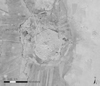
Figure 23: Ancient city of Harran [CORONA atlas]
One example can be seen along the banks of the Balikh River Valley in southern Turkey and northern Syria. The Harran Plain on the Turkish side of the border (Figure 22) has seen intensive agricultural development, driven by diversion of water that would once have flowed into Syria towards irrigation of the plain in Turkey. Surrounding the major ancient city of Harran (classical Carrhae; Figure 23), hundreds of archaeological sites are visible in CORONA imagery from 1968 and 1969. Many of the prominent sites have been recorded by archaeological surveys of the region (Yardimci 2004), but a large number of smaller sites remain undocumented by archaeologists. A comparison to modern Google-provided Quickbird imagery shows that many such sites are no longer visible. In some cases, the much expanded growing season may simply make the window in the agricultural cycle when sites would be visible much shorter, meaning that modern images acquired at just the right time of year could still reveal sites. In other cases, it is likely that sites have been damaged or even flattened by ploughing and irrigation.
Figure 24: Lower Balikh River at confluence with Euphrates, Syria [Static images | CORONA atlas]
Figure 25: Al-Raqqa, Syria [Static images | CORONA atlas]
At the southern end of the Balikh Valley, at the point where it converges with the Euphrates River in Syria, a similar process of agricultural intensification is evident (Figure 24). In this case intensification is fed largely by irrigation water derived from nearby Lake Assad. Surrounding the important medieval town of al-Raqqa (Figure 25), dozens of archaeological sites can be seen in CORONA imagery from 1968, including the important Chalcolithic site of Tell Zeidan (Figure 26; Stein 2011). As in the Harran, many of these sites have now been obscured or destroyed by agricultural intensification in the region.
Figure 26: Neolithic and Chalcolithic site of Tell Zeidan, Syria [Static images | CORONA atlas]
The national border between the modern states of Israel and Egypt that runs through the arid Negev Desert is remarkable in that it is one of the few state borders easily visible from space, having been documented by astronauts using a standard digital camera (NASA 2011). The demarcation between the two countries is driven by radically different land use practices on either side of the border. In Egypt, where the Nile Valley offers abundant fertile farmland, the arid desert on the eastern edge of the Sinai Peninsula, far from centres of population, are used only as extensive pasture for herds of goats and camels. In contrast, the large, growing population within the geographically small area occupied by Israel has led since the creation of the modern state in 1948 to the continued expansion and intensification of agriculture into regions not settled for millennia. The cultivation and settlement of border areas offers a marked contrast compared to the Egyptian side. A CORONA image from May 1968 shows the transformation of the Negev Desert into cultivated areas already well underway, while comparison with modern imagery shows the continued intensification of agriculture in this region. As settlement and agriculture expand into desert areas, they inevitably have an impact on archaeological remains—in this case moving into landscapes with well-preserved remains from early phases of human history, in the Neolithic and Chalcolithic (8500–4000 BC) when desert areas received considerably higher levels of precipitation than they do today (Kuijt and Goring-Morris 2002; Winter-Livneh et al. 2010). The lack of substantial settlement in these areas in most subsequent periods has led to extremely good preservation of the remains that do exist there, but the movement of modern settlement and agriculture into them creates inevitable conflicts.
Figure 27: Negev Desert, modern border between Israel and Egypt [Static images | CORONA atlas]
© Internet Archaeology/Author(s)
University of York legal statements | Terms and Conditions
| File last updated: Fri Sept 21 2012