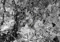
Figure 28: Archaeological survey around Tell Hamoukar, eastern Syria. In this area, virtually all archaeological sites are resolvable on CORONA imagery [CORONA atlas]
One of the ways in which CORONA imagery has proven most valuable is in aiding site discovery on regional archaeological surveys. Sites and features appear for a variety of reasons and with a range of clarity across CORONA missions. The relative visibility of sites and features can be hard to predict, being a result of many factors ranging from the agricultural cycle of the area in question, to the relative difference between anthropogenic soils and the surrounding soil matrix, to the amount of rainfall in the days and weeks preceding the time the image was captured.
Because CORONA images are essentially black-and-white photographs taken from space, archaeological sites and features are visible for much the same reasons that they can be seen on conventional aerial photography. As on aerial photographs, sites and features appear primarily as either topographic features, soil marks, and/or crop marks (Wilson 2000). Ancient settlements in much of the Near East relied on mudbrick as the primary building material, and thus many archaeological sites in the region possess mounded areas created through successive phases of rebuilding. These mounded sites, commonly termed 'tells', range from those only subtly raised above plain level to large cities attaining heights of more than 40m. Because CORONA were typically captured during the early morning or late afternoon in an effort to highlight topography, raking sunlight helps illuminate even modestly mounded sites. The exaggerated perspective on relief offered by stereo CORONA images provides an additional means to detect sites with topographic expression.
Non-mounded sites and features, or those where geomorphic and cultural processes have flattened all trace of mounding, are also often visible on CORONA imagery as soil or crop marks (Beck et al. 2007; Ur 2010; Casana and Wilkinson 2005). Anthropogenically altered soils are usually associated with areas of ancient settlement, created by the frequent input of waste, artefacts, and building materials. These processes produce soils that are significantly different from the surrounding soil matrix in terms of colour, texture, moisture retention, and other properties that are often visible on satellite imagery or aerial photography. Soil differences also affect the relative health of vegetation that grows on top of sites, and this too can sometimes be detected in imagery. Furthermore, ancient people often gathered clay and soil for manufacture of mudbricks and pottery from extraction pits nearby settlements, and these pits, while now typically infilled, are often visible as darkened features because they retain moisture in a different manner from the surrounding soils.
Importantly, the visibility of sites and features varies greatly across CORONA missions owing to differences in ground cover, soil moisture, atmospheric conditions, season, and time of day (Ur 2010). There are no absolute rules for determining which CORONA scenes are best for site visibility in a given region, but in general it is primarily important that the ground be relatively clear of vegetation, as this will obscure many sites and features. Thus, the agricultural cycle is key, as it is best if images were acquired during periods when fields are most clear, perhaps immediately following the planting of a new crop. Another major factor concerns soil moisture, as very dry soils tend to obscure differences in colour that might otherwise be visible, while wetter soils can also reveal differences in moisture retention that are characteristic of many sites and features. In very dry desert regions, sites are rarely visible on CORONA, but this can change if images are taken immediately following an infrequent rainstorm. In other areas, such as those with high topography or complex geology, site visibility is rather poor, and even the best CORONA scenes reveal little because the contrasts between the background matrix and sites' topography or soils are so minor (Beck 2007). In addition, many more transitory traces of past human activity, such as nomadic/pastoral sites or early prehistoric lithic scatters are unlikely to appear on any CORONA images. Beyond such general considerations, and other obvious factors such as cloud cover, snow cover, etc., it is useful to examine all available CORONA scenes for a given study area to determine the best quality images. While it is not a panacea, site visibility on CORONA imagery is exceptionally good in many parts of the Near East, and this fact has revolutionised the ability of survey projects to locate new sites. Below we review cases in which CORONA imagery has aided in site discovery in the context of regional archaeological surveys.

Figure 28: Archaeological survey around Tell Hamoukar, eastern Syria. In this area, virtually all archaeological sites are resolvable on CORONA imagery [CORONA atlas]
In some areas of the Near East, such as the plains of northern Mesopotamia in the region known as the Jazireh, intensive surveys conducted over the past decade with the aid of CORONA imagery have found that virtually all significant archaeological sites are clearly visible in the best scenes. In the relatively small survey area around Tell Hamoukar (Figure 28), researchers began by first carefully analysing CORONA satellite imagery of the region. In addition to ground-truthing site-like features identified on CORONA, researchers undertook intensive pedestrian transects to look for more subtle evidence of habitation in the form of low-density artefact scatters. However, pedestrian transects failed to locate any evidence of ancient habitation that was not already resolvable on CORONA imagery (Ur 2002; 2010). A much larger survey conducted around Tell Brak used CORONA imagery in combination with other multispectral imagery including Landsat and ASTER to locate archaeological sites and other landscape features, and similarly concluded that CORONA represents an invaluable resource, revealing the location of nearly all significant sites (Wright et al. 2006-7). The difference in rates of site discovery by these CORONA-aided projects versus other, earlier surveys (e.g. Eidem and Warburton 1996) is remarkable.

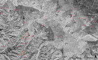
Figure 29: Archaeological survey in the lower Amuq Valley, southern Turkey. Most sites in lowland plains are visible, but almost none in upland areas
In other areas of the Near East, such as in the Orontes River Valley of the northern Levant, CORONA imagery is less of a solution due to the more active geomorphic environment in the region, the existence of denser and more varied vegetation, the complex and diversified topography, and more heterogeneous architectural traditions, utilising wood, stone and reed, alongside mudbrick. But even in these areas, nearly all archaeological sites preserved at the surface can be recognised in specific environmental zones, particularly plains and river valleys. In the Amuq Valley of southern Turkey, for example, hundreds of sites of all periods and sizes are clearly visible in lowland plains, but are almost impossible to recognise in adjacent upland areas where they are obscured by steep, dissected topography or even forests (Figure 29). The Amuq Plain was first surveyed in the 1930s by Robert Braidwood (1937) and then was subjected to more intensive survey by the Amuq Valley Regional Project team from 1995–2000 (Verstraete and Wilkinson 2000). Despite these substantial efforts, analysis of CORONA satellite imagery of the region readily recognised nearly twice the number of archaeological sites in the plain than were previously known (Casana and Wilkinson 2005). The majority of these sites were topographically flat or nearly so, making them far more difficult to recognise on traditional surveys than the many other prominent mounds found throughout the region. While most of the sites or site-like features visible on CORONA imagery have not yet been visited by the survey, a large number of those that have date to the Roman-late Roman periods (150 BC–AD 600), a phase that was previously very poorly represented in settlement data (Casana 2003; 2007).

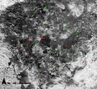
Figure 30: Qoueiq River Valley, western Syria. Archaeological survey was undertaken prior to the availability of CORONA imagery, and dozens of sites have yet to be recorded by archaeologists
While a growing number of recent archaeological surveys in the Near East have begun to incorporate CORONA satellite imagery into the planning and execution of surveys, the vast majority of past surveys conducted since the early 20th century did not have access to this remarkable resource. Experiences of recent projects show how many sites were likely missed by earlier surveys that employed less intensive methods. For example, in the Qoueiq River Valley north of Aleppo, Syria, a survey project in the late 1970s attempted to record as many sites as possible (Matthers 1981), but without access to a resource like CORONA imagery, the team missed many sites. Dozens of sites can be seen on CORONA imagery in between the ones discovered and mapped by the project (Figure 30), highlighting how little we may know about settlement history in many parts of the Near East. Our ongoing NASA-funded project at the University of Arkansas is now working to bring together all previous surveys across the northern fertile crescent and to document all archaeological sites or site-like features visible on CORONA imagery.
© Internet Archaeology/Author(s)
University of York legal statements | Terms and Conditions
| File last updated: Fri Sept 21 2012