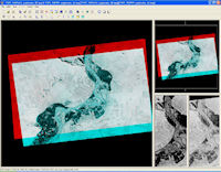
Figure 48: Stereo CORONA images displayed in ERDAS Stereo Analyst. Note that orientation of the images must be perpendicular to the flight path to enable stereo viewing
Human stereoscopic vision is the ability to merge two images of an object, taken from two different perspectives, and to grasp information on relief and depth (Campana 1977). This information is possible as two eyes create a parallax of the target object, and the displacement is translated into the distance between the eyes and the object. A main tenet of the CORONA KH-4A and KH-4B systems was stereo image acquisition, a capability designed to help map and interpret features in a similar manner to that used for aerial photography for decades (Day et al. 1998). These CORONA satellites possessed one aft and one forward looking camera, mounted with a 30 degree separation angle to provide stereo images of the terrain. Because the separation between forward and aft CORONA images is greater than the angle between our eyes, topographic expression of features is significantly exaggerated in a stereo view, making recognition of subtle topographic differences quite easy.
This stereo capability enables better image interpretation, and in a region like the Near East where so many sites possess topographic expression, often in the form of mounds, stereo analysis of imagery holds obvious potential (Casana and Cothren 2008; Galiatsatos 2010). In addition, CORONA stereo images also provide a means to observe the topography of the historic landscape. Massive terrain levelling efforts connected to irrigation and industrialised agriculture (see A Changing Landscape) have flattened the relief that existed in many areas during the 1960s, while individual archaeological sites have often been damaged or completely bulldozed. Historic stereo views provided by CORONA offer the ability to observe these changes and evaluate the landscape prior to recent topographic modifications. In the same way, detailed topographic analysis can aid in other fields, such as geomorphology, in that topographic changes driven by erosion, fluvial action, or tectonics can be observed and mapped.

Figure 48: Stereo CORONA images displayed in ERDAS Stereo Analyst. Note that orientation of the images must be perpendicular to the flight path to enable stereo viewing
The simplest means to view CORONA in stereo involves the display of two overlapping images from the forward and aft cameras of the same mission/revolution within one of many available viewers (Figure 48). Extensions to ArcGIS, ERDAS Imagine, and most major GIS packages offer such capability, as do many free viewers available online. To enable the human eye to perceive CORONA comfortably in stereo, the two images must be orientated perpendicular to the flight path of the satellite, usually with the forward image on the right and the aft image on the left, such that north is to the left of the screen. This is necessary because the orientation of the cameras must mimic the orientation of the human eye. The images can then be displayed in any number of ways, the simplest being as an anaglyph in which one image is tinted red and another tinted blue and then viewed through traditional red-blue 3D glasses. Because CORONA images are black-and-white, little information is lost through display as anaglyphs. More sophisticated viewing strategies, such as the active shutter lens technology now common in the gaming and television industries, are also possible. Such techniques can reduce eye strain if viewing stereo images for extended periods and offer crisper details than traditional anaglyphs. Any of these technologies will require occasional adjustments along the x-axis of the images to maintain comfortable viewing, particularly when images cross areas of particularly steep terrain.
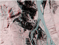
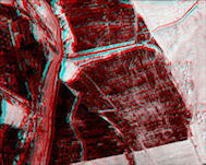
Figure 49: Anaglyph of Euphrates River Valley, Syria (requires red-blue 3D glasses for viewing)
Figure 50: Anaglyph of Tell Jouweif, Syria, cut in half by movement of Euphrates River (requires red-blue 3D glasses for viewing)
Stereo analysis offers a powerful means of viewing archaeological landscapes because the relationship of sites and features to topography is so apparent. In one example from the Euphrates River Valley of Syria, numerous mounded archaeological sites are visible within the active floodplain as well as on the high terraces above. Zooming in to one site in the floodplain, we can see quite clearly how this particular site, Tell Jouweif, has been cut in half by the meandering of the Euphrates River channel (Figure 50; Wilkinson 2005, 156).
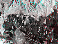
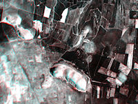
Figure 51: Anaglyph of Islahiye Plain, southern Turkey (requires red-blue 3D glasses for viewing)
Figure 52: Close-up of an area in Figure 51 showing a large limestone hill and small, mounded sites adjacent (requires red-blue 3D glasses for viewing)
Stereo analysis of CORONA also greatly enhances its power as a site prospection tool and a means to interpret known sites and features. For example, in the Islahiye Plain of southern Turkey, the region surrounding the well-known site of Zincirli has been only cursorily surveyed (Alkim 1969) and many sites remain unrecorded. In this complex landscape, it is often difficult to distinguish mounded archaeological sites from other features such as depressions, patches of unusual vegetation, soil disturbance, or geological features. However, because CORONA substantially exaggerates topographic relief when viewed in stereo, subtly mounded sites appear with greater clarity than they do even in the field. Two small, round mounded features are visible that are slightly lighter in colour than the surrounding agricultural plain, just to the south and west of the large limestone hill at the bottom centre of the image (Figure 52). The size, shape, and location of these features strongly suggest that they are small archaeological sites, and a visit to the area during the 2007 season at nearby Zincirli confirmed this fact. While these features appear prominently in stereo, in traditional 2D CORONA images they would be difficult to distinguish from other light-coloured patches, such as the lacustrine feature indicated on the image. Stereo analysis thus constitutes a powerful site prospection tool because it enables us to differentiate mounded features from flat or depressed areas, as well as from other non-cultural surface anomalies, and thus greatly improves the efficiency of imagery-based surveys.
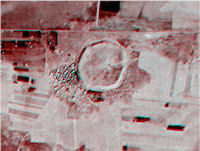
Figure 53: Anaglyph of Umm el-Marra, Jabbul Plain, Syria (requires red-blue 3D glasses for viewing) [CORONA atlas]
Stereo images also aid in interpretations of known sites, as in this example showing the site of Umm el-Marra in western Syria. The site, which has been the subject of ongoing excavations since the 1990s (Schwartz et al. 2012), appears on a 2D CORONA images as a distinct round feature, but it is not easy to see more subtle topography of the tell (Figure 53). A stereo image of the site reveals that it is surrounded by a topographic ridge cut by several gullies, the remains of a fortification wall and gateways, while the centre of the site possesses a small, elevated mound. These features, likely dating originally to the 3rd millennium BC occupation of the site, have been somewhat obscured by continued settlement during the 2nd millennium BC, but they are nonetheless quite evident in the image. A site configuration featuring a circular fortification wall surrounding a central citadel, a so-called kranzhugel or wreath-mound, is well-known during the Early Bronze Age (Akkermans and Schwartz 2003, 256). Many sites on the arid margins of the fertile crescent from the period display a similar morphology, such as the well-known site of Tell Beydar (Figure 54). This example illustrates the potential of stereo analysis to reveal subtle but important topographic features on even well-known sites, and thus aid in their interpretation.
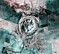
Figure 54: Anaglyph of Tell Beydar, eastern Syria, a kranzhugel-type site of the 3rd millennium BC (requires red-blue 3D glasses for viewing) [CORONA atlas]
© Internet Archaeology/Author(s)
University of York legal statements | Terms and Conditions
| File last updated: Fri Sept 21 2012