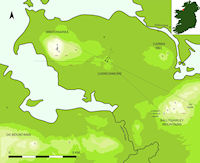
Figure 1: The Cúil Irra peninsula (after Bergh 1995) showing seasonal axis

Figure 1: The Cúil Irra peninsula (after Bergh 1995) showing seasonal axis
Listoghil [SL014-209022-] [166242/333452], also designated Carrowmore 51, is a national monument located 3km west of Sligo town, at the centre of the Cúil Irra Peninsula in Carrowmore Td. Sligo, Ireland (Figure 1). It is the central monument in the Carrowmore passage tomb complex (Figure 2); approximately 30 satellite tombs surround it at distances of up to 0.5km. The Carrowmore complex straddles two ridges running east-west, like a spine in the peninsula. The land falls to the sea on either side. Listoghil occupies the highest position of the most northern of these, c. 59m above sea level. The monument today serves as a landmark; it overlooks the visitor centre and surrounding monuments. The chamber at its heart is open to the air, and accessible via a passage of gabions. The cairn covering (and passage) is a reconstruction completed by the Office of Public Works in 2004.
The landscape surrounding Carrowmore has the character of a bowl encircled by hills and low mountain ranges, many of which bear passage tombs. Four kilometres to the west stands Knocknarea Mountain (330m) with Miosgán Meadhbha (Queen Meadbh's cairn) at its summit, a memorable combination of man-made monument and mountain that visually dominates the peninsula and its hinterlands. Bergh places the first of three episodes in the Neolithic history of Knocknarea in a period of time before Queen Meadbh's cairn was built. In that context,
the isolated and eye-catching limestone monument of Knocknarea was the focal point in the Cúil Irra region and beyond. Its presence influenced the location of the megalithic cemetery at Carrowmore at the foot of the mountain, a location directed by the natural landscape (Bergh 2002, 150).
Six kilometres south-east of Listoghil, the metamorphic hills of the Ballygawley range form a physical barrier between the Cúil Irra peninsula and the mainland. In common with a number of other sites in the Ox Mountains, notably Croghaun and Doomore, they are marked by hill-top passage tombs. The Carrowkeel passage tomb complex lies 22km south-southeast and enjoys intervisibility with Listoghil.
The life history of Listoghil is punctuated by a series of radical changes. Indeed changes may have given birth to it. As stated earlier, Listoghil marks a series of ritual and morphological innovations, and perhaps a revolution.
The phases of Listoghil are important from the perspective of its interpretation as a potential deliberate astronomical alignment and perhaps as a position from which observation was conducted. In this regard, the phases ought properly to begin before the construction of the monument that was subsequently disturbed by road-builders in the late 17th or early 18th century. Stone packing found just south of the kerb by Burenhult was interpreted by him as belonging to activities prior to the erection of Listoghil. He suggests that this may be a remnant of an earlier monument (1998b, 17). We therefore may characterise the preliminary stage as a period of interest in the future site of Listoghil. Such interest is demonstrated by the orientation of 12 of the Carrowmore satellite monuments towards this area, and even by the orientation of other monuments in the district, such as the Knocknarea satellite tombs (Bergh 1995). Earlier usage of the pre-monument site may be indicated by C14 dates recovered by Burenhult (1998a) from stone packing on the platform.
The monument at Listoghil stands on an artificially-raised platform of earth. The platform, intentionally or otherwise, provided a level working surface for the megalith builders. It also created a kind of raised walkway extending about 8m from the base of the monument. From its highest (north-westerly) point the platform grades to the south-east, where it runs out into a gentle incline. Drawn as a circle, the platform would be about 48m in diameter. In the evaluation section of his preliminary report (a final report is still forthcoming) Burenhult proposed a series of construction stages, starting with the removal of the contemporary grass sod and topsoil before the building process began (1998a).
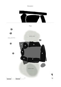
Figure 3: The Listoghil chamber (after Burenhult 1998b, Figure 12)
The chamber is positioned approximately centrally with respect to the kerb. Six orthostats (to which Burenhult assigned letters B-G) form a single compartment 2.3m x 1.49m (Figure 3). The chamber stones seem to have been selected on the basis of having at least one flat side which was always inward-facing. This characteristic gives a sense of an effort to impose regularity on the internal volume of the chamber. The structural orthostats are, with the exception of stone E, set quite shallow in the ground. Each orthostat of the chamber touches its neighbour at some point. The chamber is covered with a roof-slab that Burenhult estimates at six tonnes. The limestone slab is 3.03 x 2.76m on its square side; on the other side it curves from corner to corner (a colleague calls it 'the grand piano stone'). It tilts 6.1° from horizontal, rising towards the east-southeast. A series of concentric circles or arcs are lightly carved on the front edge of the roof-slab, just above the opening between stones B and C. A recent paper pronounces this to be the work of Neolithic carvers (Hensey and Robin 2011, 125).
The weight of the roof-slab is borne directly by orthostats E and G. In the other instances, sandstone 'wedges' arranged on top of the orthostats are used like dry-walling to set the angle of the roof-slab and to carry its weight. This indicates, Burenhult remarks, 'that the positioning of the roofslab was very important' (1998a, 12). Stone B finishes in a blunted peak, a gable shape, about 13cm below the roof-slab (Figure 4).
A later section describes effects within the chamber that could only occur if (a) the chamber was free-standing and uncovered; or (b) light was admitted via a passage or other opening. The passage question is discussed later, but the arguments for the existence of a free-standing Listoghil chamber may be summarised thus:
Still preserved in situ, a kerb of 101 stones, 32-35m in diameter, surrounds the base of Listoghil's reconstructed cairn. The stones are mostly gneiss; five are of limestone or schist. One (K8) is of Slishwood serpentine (Patrick J. McKeever, pers. comm.). The stones, average length just under a metre, are laid lengthwise. One gneiss boulder, markedly bigger than the others (2.2 x 0.95 x 0.65m), is known as the western marker stone. I numbered it 1 in my survey in 2007, and proceeded anti-clockwise (in plan) in numbering the others (Figure 7). K61 is equivalent to Burenhult's Kerb 1 (1998b, 15); as he provides only an unnumbered drawing based on a helicopter photograph, showing 100 kerbstones, I felt it necessary to revisit the numbering scheme. After the construction of the kerb, cremations were deposited behind certain kerbstones, only a limited number of which were excavated. Depositions of human bones were discovered at the base of two of these. On the inside of K1, under the cairn, a cremation (2462.5g) was spread out on a flat stone. A concentration of cremated bones was also found on the inside of K19, again under the cairn (Burenhult 1998b, 17).
It is noteworthy that research on monuments in the Cúil Irra area is suggestive of an interest in the cardinal points. For example, the probable Neolithic cairn at Cairns Hill West has a boulder placed 5m due north from the edge of the cairn, called by Bergh a north marker (1995, 233), boulders in similar contexts are found at Miosgán Meadhba. A partial alignment of sites along a north-south axis occurs on Knocknarea. The largest stone in the Listoghil Kerb, K1, is set almost due west of the chamber. (Cairn F, the largest monument in the Carrowkeel complex, 22km to the south, is pointed almost directly true north.) By what means might the builders of the Listoghil kerb have established the cardinal points? Possibly by the diurnal motion of the heavens, or the direction of the shadow of a gnomon at its shortest, marking midday. Markers of directionality provide crude but fundamental evidence of interest in astronomical direction.
Limitations in dating resolution and later disturbance mean that it cannot be established how much time elapsed between the construction of the chamber and the covering mound of stones being built (Burenhult 1998b, 20). Furthermore, the original extent of this cairn is unclear, as is the question whether it ever had a passage in antiquity.
However, some kind of a cairn did once exist at Listoghil. Before excavation, cairn material surrounded and partly covered the chamber. Remains of intact flagging was found, built up partly under the roof-slab and thoroughly constructed of flat, overlapping slabs (Burenhult 1998b, 6). Twenty or so of the surrounding circle of kerb-stones protruded from an uneven mound of loose stones, in places to a height of 2.5m. To the north, the mound was scooped out to ground level. The scattered cairn material covered approximately 250m² and was 'a very uneven surface of partly grass-covered heaps of smaller stones' (Burenhult 1998b, 3). Four field walls converged at Listoghil, some on the roof of the exposed chamber, as shown in a late 19th-century drawing by William Wakeman (Figure 5).
Gabriel Beranger visited Listoghil in 1779, describing 'a cave'. A strong local tradition persisted of calling Listoghil 'the Cave' at the end of the 20th century. The 'cave' was the gap to the right of stone B, which allowed nimble people to crawl part way into the chamber. In the modern era the Irish name Lios a' tSeagail was in use; it is recorded in the 1912 25-inch OS map. It was translated for Elcock as 'Ryefort' (Elcock 1884, 250). (Today, locals pronounce the name 'Liss-thoh-hill', with the 'o' in the middle syllable sounded as in the English word 'hot'.) Sixty years after Beranger's visit, George Petrie described Listoghil; 'In its present state of dilapidation it is impossible to describe its original proportion with any certainty' (Petrie 1837, 22).
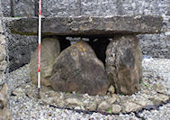
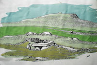
Figure 4: View of Listoghil chamber from east
Figure 5: Listoghil in the late 1800s (after William Wakeman, reproduced in Borlase 1897, 166)
)
The cause of the destruction is obscure. Charles Elcock, at the end of the 19th century, recorded local accounts of the use of Listoghil as a quarry for 'road metal' (Elcock 1882, 250). As this was already accomplished in 1779 when Beranger visited, if this is a genuine memory, it must be one that spans multiple generations. McTernan (1990, 8) writes that in 1628 the first stone bridge spanning the tidal mouth of the Unshin River at Ballisodare was built by Maria Jones, wife of the soldier, Roger Jones, the first burgess of Sligo. It is likely that Listoghil was ransacked during or after this era of road building.
Burenhult's Swedish archaeology team excavated one-third of Listoghil, including the chamber, in 1996-98. The excavators did not reconstruct or move the central chamber. Because excavation under the orthostats threatened to destabilise the structure, work was undertaken in 1998 to correct this.
The monument now rests in a concrete frame, strengthened by iron mesh…The walking area around the chamber corresponds to the level once used by the builders of the monument, before the erection of the cairn (Burenhult 1998b, 20).
Unburnt and cremated human (and also animal) bones were found scattered inside and outside the chamber. Nine radiocarbon (AMS) dates (3640-3380 cal BC) from bones and from charcoal in the area of the chamber and on the surface of the mound indicate, according to the excavator, a limited time span for the construction and (primary) use of the central chamber (Burenhult 2005, 27). Caution in interpretation is advocated by Cooney et al. (2011, 656), citing anomalous dates from under the cairn, but he concludes that Neolithic dates from the layer of soil under the cairn probably provide termini post quos for construction. These dates converge around c. 3550 cal. BC (Burenhult 1998b, 20). The human remains were identified as coming from both children and adults. Among the material finds listed in the 1998 report are: pounding stones, a metal ring, a bone dice, a stone pendant or casting stone, broken with a drilled hole. The discovery of a metal ring and a 'yellow glass bead' discovered between kerbstones 69 and 71 to the north, provides evidence of re-use of the site. Burenhult documented a kite-shaped flint javelin head, 114 x 39mm, removed from the burial chamber by 19th-century antiquarians but still curated in Alnwick Castle, Northumberland (Burenhult 1998b, 1).
Even after excavation, a coherent picture of the original condition of the monument remained elusive. Why was an antler (or bone) dice (thought by Burenhult (1998b) to be from the Viking period) found within a few metres of the chamber, but under the remnants of the cairn?
The existence or otherwise of a passage is an important question in terms of the possibility that a sunrise effect continued to be observed in the chamber after the cairning of Listoghil. The folklore narrative of a cave (many passage tombs were called caves in Ireland), together with a radiocarbon sample dating to c. AD 550 (Ua-11581), found between orthostats E and F in the chamber, might be cited in support of the existence of a passage or opening in the cairn. Burenhult refers to two carbon dates which could indicate access to the chamber in Iron Age and early Christian times, indicating that 'the cairn may not have been as intact as suggested in later sources' (Burenhult 1998b, 17). But his excavation along the likely line of a passage from the front of the chamber was inconclusive; he found no evidence of orthostat sockets or stone packing.
An open passage would have allowed the Samhain/Imbolc event to be observed from the area of the chamber. If no passage was present, and Listoghil had a tall enough covering cairn, the lighting effect could not have occurred (The kerbstones are of insufficient height to significantly influence the effect). O'Kelly (1983, 96) proposed that the 'light box' of Newgrange may have been closed and re-opened at intervals by the removal of two blocks of quartz. However, a convincing revision of the evidence by Eriksen (2008) suggests that Newgrange was eventually enclosed in a covering mound. A covered passage tomb could still be used as an observation position from the platform provided by a flat-topped cairn. But why go to the trouble of engineering a spectacular event at sunrise and then hide it? Perhaps new orthodoxies emerged, or perhaps the effect was not meant to be witnessed by the living. As Ruggles and Hoskin remark of Newgrange,
we must note that the sunlight was intended to fall upon the bones of the dead, not seen by the living, and that even a living occupant of the central chamber would have learned only a very approximate date for the solstice (1999, 3).
The cairns of the Cúil Irra region e.g. Cairns Hill East, Cairns Hill West, Knocknarea 3 (Miosgán Meadbha), and Knocknashee are all flat topped, but this characteristic is absent from the Carrowkeel cairns. Did this level terrace serve a functional as well as a stylistic purpose? Visually impressive as this feature tends to be, both in aspect and prospect, it was potentially an ideal position for both (1) observation and (2) ceremony.
Reconstruction began at Listoghil even as the research excavation was proceeding. During a two-week period in 1997 the complete boulder circle was exposed, and, at the same time, additional stone material was brought on to the monument. A plastic and steel mesh was laid by the archaeologists on the original cairn, to distinguish the excavated and unexcavated areas from the reconstruction.
The building material was collected from some of the field walls at Carrowmore, as well as from dumped stone material in the small quarry just south of the visitors centre (Burenhult 1998a, 15).
The Office of Public Works began full-scale rebuilding of the cairn in 2004. Collected field-wall stones (and other stones) were piled to a height of just less than four metres. The restoration provides a flat top c. 20m in diameter. A rectangular space, 5m x 8m, formed from gabions, was created around the chamber. The resulting enclosure was offset towards the east, leaving an empty area for visitors. A 'passage' of gabions (along the line of Burenhult's Excavation Area B) 2m wide and 13.7m long was constructed. This work was supervised by an archaeologist; underlying the loose cairn stones (to the west of the 'proposed entrance') was
…a mixed clay and stone layer…Finds from this section face included modern pottery and glass, as well as occasional animal bone…the ground surface was cleaned back revealing the orange/brown boulder clay…It was not possible to determine the depth of the boulder clay, as the exposed section faces posed significant risk from collapse and it was necessary to immediately commence the laying of gabions (Fitzpatrick 2003).
At the entrance to the new passage, kerbstone 43 was left in place. Some gabions were filled with blue, sharp-edged, quarried limestone, others with local field wall stones, creating an odd contrast. The area around the chamber was covered with pea gravel (Figure 4).
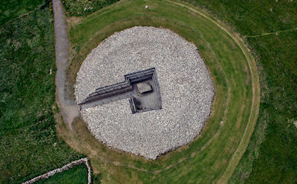
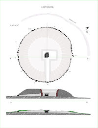
Figure 6: Listoghil, restored. (Photo: Thorsten Kahlert. Reproduced with permission)
Figure 7: Listoghil plan and section. Bottom section: the mound pre-excavation, based on Burenhult totalstation data (1998b, Fig. 3)
The removal of the field walls changed the landscape, creating open parkland. Some of the walls were, no doubt, of considerable antiquity, but no report was produced on their destruction. Only unpublished preliminary reports on the Listoghil excavation were produced by Burenhult. Perhaps the most difficult aspect of the restoration is that a number of new kerbstones have been introduced, which are difficult to distinguish from the originals (although the plastic cover is useful in this regard). There is a danger that information may be obscured by this new phase of work undertaken at a different pace, with different values and different ways of looking at materials. Work remains to be done in re-evaluating the excavation and the reconstruction of Listoghil (Figures 6 and 7).
© Internet Archaeology/Author(s)
University of York legal statements | Terms and Conditions
| File last updated: Wed Jul 18 2012