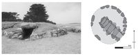
Figure 13: The Scillonian entrance grave of Innisidgen Carn (Source: Author).
Entrance graves comprise roughly circular mounds of stone and earth, revetted by a kerb and containing an accessible stone burial chamber (Figure 13). Eighty-three entrance graves have been found on Scilly, in contrast to nine on the Cornish mainland (Barnatt 1982; Ratcliffe 1989). The dating of these monuments remains problematic because, like many other chambered cairns in Western Britain, they appear to have been in use for many generations. No current radiocarbon dates are available and their dating is based entirely upon pottery chronologies. What we do know is that they appear to go out of use around 1600 cal BC, at the end of the Early Bronze Age. Based upon current analysis of the sequences of deposition from these monuments a late Neolithic/Early Bronze Age construction date would seem most likely, although an earlier date for some remains possible (Jones and Thomas 2010; Robinson 2007).
Figure 13: The Scillonian entrance grave of Innisidgen Carn (Source: Author).
Entrance graves occur around the Atlantic coastline of the archipelago, where they are a feature of higher ground (Figure 14). Historical accounts suggest the presence of entrance graves within the interior of St Mary's; however, this number is limited to one or two possible sites only (Johns 2012). It could be argued that the present distribution of these monuments is deceptive, as low-lying sites may have been lost through inundation. The destruction of entrance graves through inundation is unlikely as the amount of land lost through sea-level change amounts to only around 15% of the present-day landmass (the majority of which is from around the islands' coastline). This loss of land to the sea holds two implications for the distribution pattern of entrance graves: firstly, that if monuments were lost through inundation their number is likely to be small; and secondly, that any sites lost would originally have been located along the ancient coastline. Furthermore, while entrance graves are substantially built monuments, unlike other archaeological sites, such as houses and field boundaries, they are absent from the present-day intertidal zone. On balance, it would seem that very few entrance graves have been destroyed by sea-level change and their present distribution accurately mirrors that of prehistory.
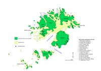
Figure 14: The distribution of entrance graves on Scilly (Source: Author).
While a prehistoric coastal distribution pattern can be identified for entrance graves, they are not evenly distributed throughout the archipelago, being absent from some islands such as St Agnes, Ganilly and Annett, and with restricted distributions on Bryher and Tresco. Similarly, over 40% of these monuments occur in only three locations: Porth Hellick, Kittern Hill and Samson. The location of entrance graves in close proximity to the ancient coastline means that the sea is an ever-present element of their settings. While proximity to the sea was important in the choice of setting for entrance graves, those locales chosen did not command the most extensive views over the sea. This is demonstrated by the absence of monuments from locales on the periphery of the archipelago, such as Shipman's Head Down, Wingletang Down and Peninnis Head, which command the most extensive views over the sea. Instead, entrance graves are sited to command specific and localised views.
One interpretation of these data is that entrance graves are being located within specific landscape settings to emphasise particular sea zones. This interpretation argues that the sea, as a metaphoric or symbolic resource, is not important in itself, but rather that only certain areas of the sea are significant. It is argued that the key to interpreting these monuments is firstly, to explore their landscape settings from the sea, and secondly to relate their distribution and settings to potential prehistoric sea-borne movement within the archipelago.
The major entry points into the archipelago – Crow Sound, St Mary's Road, St Mary's Sound and Tean Sound, correspond well with the distribution of entrance graves. The implication here is that the locations of entrance graves mark out movement on the sea and, in particular, approach and entry into the archipelago. The presence of entrance graves on Arthur and Innisidgen mark an eastern entry into Crow Sound; monuments on Gugh, the western limit of an eastern approach into St Mary's Road; monuments on Samson, the western limit of a southern approach into St Mary's Sound and monuments on White Island, Tean and St Martin's, a northern approach into Tean Sound. Similarly, the high concentration of entrance graves along the eastern coast of St Mary's might relate to the importance of this coastline as the first landfall encountered during a crossing from the mainland.
The marking of these locales through the construction of entrance graves highlights the significance of these places for safe movement on the sea. The significance of these journeys is further emphasised through the powerful presence of ancestral remains within the chambers of the entrance graves. By placing ancestral remains at the entry points to the archipelago they guide the living, both practically and symbolically, to the safety of harbour and through this relationship safe passage on the sea was articulated at the outset and conclusion of each voyage. Furthermore, by emphasising these significant island locales through the construction of monuments, connections are drawn between the seafaring activities of the living and those of the ancestors, thereby creating a genealogy of the seascape.
If the distribution of entrance graves relates to movement and activities within the seascape, we also need to account for the absence of these monuments from within specific areas of the archipelago. The absence of monuments within locales such as Wingletang Down, Annet and Shipman's Head can be accounted for as these locales are associated with exposed coastlines that offer little shelter or harbourage and where sea-borne movement would be restricted (Brandon 1999). Similarly, the absence of entrance graves from locales along the eastern coastline of Tresco might be accounted for by the potential for extensive intertidal sandflats and thus the inability to launch or land boats easily.
While the landscape settings of entrance graves provided a powerful visual discourse for activity on the sea it would be misleading to suggest that all of these monuments are visible from the sea around the islands. While an attempt was made to establish which of these were visible, the sea-based logistics of this proved beyond the scope of this article. What is clear is that from the sea the most visually significant elements of the island landscape are the granite tors that punctuate the archipelago's Atlantic coastline. In order to explore further the significance of the coastal distribution of entrance graves, attention must be focused on these tors and their relationship with entrance graves and movement on the sea.
On Scilly, granite tors and outcrops form the most visible elements of the island landscape, many of which can be picked out and identified kilometres offshore (Brandon 1999). The importance of such wayfaring points for modern seafaring is clearly demonstrated in their inclusion on both modern and historical charts and pilot guides (Corporation of Trinity House 1749; 1808; Rowett 1869; Brandon 1999; Admiralty 2001). Of particular importance are pilotage guides produced for the training of navigators for the islands tourist and fishing vessels (Brandon 1999; Norm 1980). These guides demonstrate the importance placed upon local knowledge such as the correct identification of landmarks in order to avoid dangerous rocks and currents and to locate important locales within the seascape, for example holes within the seabed into which lobster or crab pots are placed. Through wayfaring, a detailed and intimate knowledge of both surface and seabed topography is generated through the correct identification of landmarks.
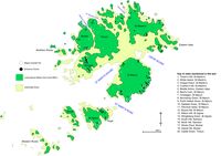
Figure 15: The relationship between Scillonian entrance graves and the major granite tors of the archipelago (Source: Author).
Granite tors are found along the Atlantic coastline of Scilly where they dominate cliff tops and headlands; these tors have been mapped and characterised by Mitchell and Orme (1968) and Scourse (1986). While tors have a wider distribution within the archipelago than entrance graves, a strong correlation exists whereby entrance graves are located in close proximity to coastal tors (Figure 15). For example, entrance graves at Innisidgen, Tinker's Hill, Gweal Hill, and Middle Arthur are located in close proximity to tors (Figure 16a-d); while on Samson and Cruther's Hill, St Martin's, the linear arrangement of entrance graves mimic the sinuous spines of granite that dominate the summit of these hills. At Works Carn, Bryher, an entrance grave has been sited directly on top of a hillside tor (Figure 16d). Through the construction of entrance graves in close proximity with tors, their builders were highlighting the importance of such features to the everyday world of prehistoric Scillonians. It is not that granite tors have inherent significance, but rather that, as they represent the most visible locales of the landscape when viewed from the sea, their significance is derived from sea-borne movement. Equally, not all tors visible from the sea are emphasised through the construction of monuments; only those that are useful for safe navigation are marked out through architectural elaboration.
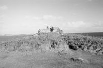

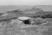
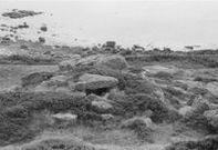
Figure 16a: View from the entrance grave of Innisdigen Carn, St Mary's, towards a large granite tor (Source: Author)
Figure 16b: The entrance grave of Litte Arthur, Eastern Isles, visible in the foreground, is located in close proximity to a large granite tor (Source: Author)
Figure 16c: The entrance grave of Lower Innisdigen, St Mary's, is constructed inland from a prominent granite tor, visible in the background of the photograph (Source: Author)
Figure 16d: The entrance grave of Works Point, Bryher, is constructed directly on top of a granite tor (Source: Author)
Today lighthouses and marker buoys aid wayfaring; however, natural landmarks, such as tors, remain the principle means by which seafarers locate themselves within the islands' dangerous waters. Evidence for the present-day and historical importance of coastal features, many of which are only apparent from the sea, such as cliffs, inlets, tors and islets, is illustrated through the naming of these features on maps and charts (Admiralty 1998; Thomas 1979a; 1979b). In prehistory everyday activities on the sea around Scilly, would primarily have been carried out within coastal waters. In these waters, the tors and outcrops that encircle the Atlantic coastline of the islands would have provided the most prominent wayfaring points. With an intimate knowledge of the island landscape and its shifting perspectives, prehistoric Scillonians would have acquired knowledge of the sea and, through this process, the sea would have become invested with significant locales and seaways. Tors would have played an important role in this socialisation of the sea. Tors may have become associated with sea tenure, ancestral fishing grounds, pilotage routes and mythological events upon the sea (Davis 1989; Morphy and Morphy 2006). While the precise location of significant locales within the ancient seascape cannot be reconstructed, through the identification of prominent coastal landmarks, embellished through the construction of monuments, we can appreciate the potential practical, social and symbolic importance that these locales might have held.
The importance of tors and their association with movement may pre-date the construction of entrance graves, but through the construction of monuments, the knowledge and significance of these coastal features became socialised and embedded within the lives of prehistoric islanders. If the location of entrance graves relates to movement on the sea, and particularly to entry into the archipelago, we can postulate that only those tors significant to their sea routes were emphasised through the construction of monuments. Therefore, each entrance grave was associated with a particular point within the landscape, readily visible from the sea, and may have functioned as a wayfaring marker.
Wayfaring would have been crucial for negotiating the dangerous waters of the archipelago, and this knowledge of the sea was intimately linked to knowledge of the land. While knowledge of wayfaring carries socio-economic significance in sustaining life in an offshore island environment, the socio-economic necessity of a system of wayfaring cannot be separated from a meaningful and symbolic ancestral geography. The location of burial monuments at significant locales along the coastline has drawn them out beyond the confines of the land and into the sea. Through the construction of monuments containing ancestral remains within these locales, lineages were drawn out between prehistoric islanders, ancestors and safe passage on the sea. The entrance graves therefore represent a material confirmation of the social relationships between people and places. Thus, the seascape shares many attributes with landscape in that both are socially constructed and comprise named places, mythologies, biographies and social networks.
Internet Archaeology is an open access journal based in the Department of Archaeology, University of York. Except where otherwise noted, content from this work may be used under the terms of the Creative Commons Attribution 3.0 (CC BY) Unported licence, which permits unrestricted use, distribution, and reproduction in any medium, provided that attribution to the author(s), the title of the work, the Internet Archaeology journal and the relevant URL/DOI are given.
Terms and Conditions | Legal Statements | Privacy Policy | Cookies Policy | Citing Internet Archaeology
Internet Archaeology content is preserved for the long term with the Archaeology Data Service (ROR). Help sustain and support open access publication by donating to our Open Access Archaeology Fund.
File last updated: Fri May 31 2013