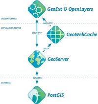
Figure 11: Open source 'Geostack' used by project (after OpenGeo 2012. Image: © Boundless 2013).
The framework of the application was based upon the OpenGeo 'Geostack' (Figure 11).
Figure 11: Open source 'Geostack' used by project (after OpenGeo 2012. Image: © Boundless 2013).
This modular, layered design comprises database, application server and user interface, using in this instance the following software:
All software is open source and details of how to obtain the software is provided (Appendix 1).
The database design essentially comprises two components, spatial (coordinates) and descriptive (attributes). Vector data is contained within a PostgreSQL 9.1 and PostGIS 2.0 database as a simple spatial table with attributes comprising the various columns within the table as a geometry collection (Figure 12 and Table 2).
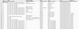
Figure 12: Screenshot illustrating spatial database structure.
| Database field | Description |
|---|---|
| GID (PK) | Unique identifier and primary key |
| Name | Name of feature |
| Feature description | Textual field to allow user to describe feature |
| Period | Date to which feature may belong |
| Geom | Geometry of point, line or polygon |
| Source | Allows user to indicate which visualisation method or methods shows feature |
| Value | Field that allows the relative value of the heritage feature to be assessed and conveyed by user-assigned numerical value 1-10 |
| Recorded by | Name of user who has transcribed feature |
To facilitate data collection that can contribute to Objective 7, attribute data field 'source' allows the user to indicate the visualisation method/s that show the features.
GeoServer, an open-source web map server, was used to house and serve data. Communication between PostGIS and GeoServer was achieved via structured query language (SQL). This allows transactions using the Web Feature Service (WFS-T) Standard 1.0.0, which allows the user, via a client interface, to modify the spatial data held within the PostGIS database. The primary reason for choosing GeoServer rather than an alternative open-source solution, such as MapServer, was the native ability to support WFS-T. MapServer does not support WFS-T and requires an additional program to be installed, known as TinyOWS, to implement WFS-T functionality. GeoServer also possesses a significantly more intuitive admin interface than MapServer, reducing the learning curve required to use the software effectively (Figure 13).

Figure 13: Example of GeoServer administration interface.
Raster images of LIDAR data were pre-seeded using GeoWebCache, which is incorporated into GeoServer, to speed up tile generation performance and enhance user experience. Given the large extent of the study area, PCA and hillshaded raster bit depth was kept to 8bit to minimise tile generation and layer load times. The images were served via Web Map Server (WMS) 1.1.1 service.
The application runtime location was client side within a web browser via JavaScript embedded within a HTML page. Application coding methods use a combination of open source OpenLayers, and GeoExt, which is based upon ExtJS JavaScript library. The full JavaScript code for the application is included in Appendix 2.
Internet Archaeology is an open access journal based in the Department of Archaeology, University of York. Except where otherwise noted, content from this work may be used under the terms of the Creative Commons Attribution 3.0 (CC BY) Unported licence, which permits unrestricted use, distribution, and reproduction in any medium, provided that attribution to the author(s), the title of the work, the Internet Archaeology journal and the relevant URL/DOI are given.
Terms and Conditions | Legal Statements | Privacy Policy | Cookies Policy | Citing Internet Archaeology
Internet Archaeology content is preserved for the long term with the Archaeology Data Service (ROR). Help sustain and support open access publication by donating to our Open Access Archaeology Fund.
File last updated: Wed Oct 23 2013