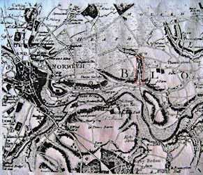
The aforementioned narratives and official documents for Kett's Rebellion can be augmented by a series of maps and written sources first identified by Carter (1984), which allow the site of Dussindale to be discerned at the intersection of Great Plumstead, Postwick, and Thorpe parishes (Figure 1). Lying to the east of Norwich, this area differs only slightly from that specified in Kett's indictment, and can be corroborated by repeated clues across several different documents. The first source to mention Dussindale explicitly after the 1549 indictment was a court book itemising the lands of Thomas Ward and his tenants in Great Plumstead and Postwick (1576). Written in an eclectic mixture of English and Latin, and containing marginal notes by John Russell, the reverend of Great Plumstead, in 1705 and an unknown hand in 1714, this work was mirrored by the later Postwick and Relatives (1734/5), a description of the area written by Russell's clerk, Thomas Harrison. As well as referring to the valley by name, both works also discuss nearby topographical features, providing the first links in a chain of evidence that can be pursued through comparison with other cartographic records.
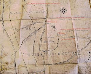
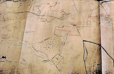
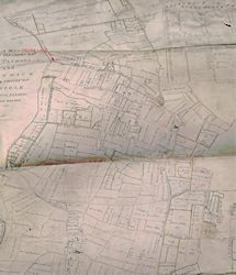
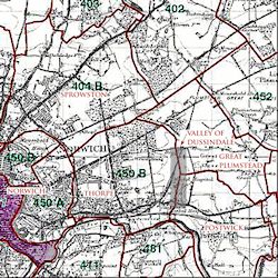
Corroboration comes from a plan by William Cooke of Tharston (1718) of sheep-fold courses (Figure 2), a birds-eye perspective produced for the Dean and Chapter of Norwich Cathedral. This map depicted Dussindale, the only work to do so directly, at the boundary of the aforesaid parishes, while also showing the surrounding features described by Ward and Harrison, aiding the valley's identification on less-explicit sources. For example, two anonymous, late 16th-century (1589; c. 1600) maps of Mousehold Heath (Figures 3 and 4) show the land west of Dussindale, but would be impossible to interpret without Cooke's plan, which portrayed areas including 'Lumners Great Close' and 'Peke Herne' that appear on all three maps, demonstrating that they encompass the same area. The lands east of Dussindale, however, were not surveyed in detail until the 1812 Great Plumstead and Postwick enclosure award (Figure 6), which recorded the position of pre-existing roads and closes alongside those created in the 19th century. The accompanying map accurately delineated areas portrayed by earlier works, including several commons featured in Harrison's text and Cooke's plan, and a drove lane marked on the 1589 map as lying to the rear of Great Lumners Close, corroborating the valley's location. This evidence can be further cross-referenced with 17th-century Glebe Terriers to discern whether 'ancient' enclosures lay open in earlier eras (Anon. 1735a ; 1735b). The only source to show the area prior to this was Faden's 1797 one-inch-to-one-mile map of Norfolk (Figure 5), which gave an overview of the entire region, although with notably less detail of the battlefield than appears on the enclosure award.