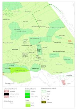
Map regression using GIS allows the aforementioned cartographic sources to be integrated with modern gradient data to form a single composite image (Figure 7).
This reveals the location of the valley in a shallow depression stretching north to south between Great Lumners Close and Readings Close and east to west from the Gargytt Hills to the commons of the Doles and Smee. The association between this region and Dussindale can be confirmed by Harrison's description of the land surrounding the Postwick Doles, which discusses the valley in relation to a number of key terrain features (in bold):
'There is also in [Postwick] a large tract of land, near 100 acres, called the Doles; lying between Postwick Field in part, and Great Cranley in part, on the east; and the Old Ditch which extends from the bottom of the valley called Dussings Dale up to the west corner of a Twenty Acre Close of the Lords of Postwick, (but lying in Thorpe bounds), on the west, and abutting north upon Great Plumstead Smeeth […] There hath been a Difference long subsisting between Thorpe and Postwick, as to The Bounds betwixt the two towns; Thorpe people taking in some part of the aforesaid Doles, and Postwick people taking in the ground between Dussing Dale, and the Old Ditch before mentioned. Both seem to be in the wrong. Dussing Dale seems to be a proper and natural division, and it would be more proper and expedient for both Towns to avoid contention, mutually to agree to make their Perambulation in that Dale, from the nook of the east part of Thorpe Common, directly towards Drove Lane, which leads unto Mousehold Heath. This seems to be a natural and lasting Division.' (Harrison 1735/6, 23-4).
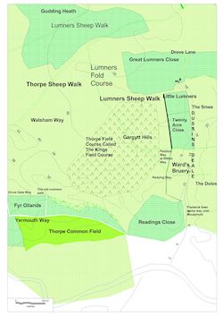
This passage's location of 'Postwick Field' and 'Great Cranly', east of the Doles, and 'Great Plumstead Smeeth' to the north, can be corroborated by the 1812 enclosure award, which referred to both areas by the same terms and recorded their location within the pre-modern landscape. Similarly, Harrison's claim that Dussindale lay on the west of the Doles, stretching 'from the nook of the east part of Thorpe Common, directly towards Drove Lane', precisely matches the path of the valley as defined by the modern gradient data. Cooke's plan (Figure 2) supports Harrison's account by showing 'Dussin's Deale' between the 'Great Old Dyke' and 'Plumstead Common called the Smee', while also depicting features missing from the latter description, namely 'Lumner's Great Close' and 'Little Lumners' at the northern end of the valley. As stated previously, these closes appear in the same positions on the 1589 map (Figure 3), suggesting that Dussindale lay to their south-east. Interpretation of this source are further enhanced by Ward's court book, which delineated the boundaries of a parcel of land, known as the 'Bruery', on the border of Postwick and Thorpe. This is particularly significant, as the area described shared many similarities with the focus of Harrison's later work, and appears on the 1589 map explicitly labelled as 'Mr Wardes Bruery', establishing a direct connection between all three sources for the landscape:
'The Lord's Bruery in Postwick stretches […] in Norwich way west up to Readings then turns north under the said close and then turns west under the said close up to Mousehold boundary to a great ditch dividing Postwick and Thorpe or Mousehold and so in the said ditch north up to a great close in Thorpe containing 20 acres and so from the south of the said close east as far as Dussindale.' (Ward 1576, fol.14r).
The court book's description of the 'Bruery's' bounds, which followed Norwich/Yarmouth Way before turning north along the back of Readings Close, indicates that they mirrored the course of 'Poswyck Townes Drove Way' along the bottom of Dussindale, before once again heading west to a point directly above Reading Close, as Figure 8 depicts. By stating the Bruery continuance west 'to a great ditch dividing Postwick and Thorpe' before heading north 'in the said ditch […] to a great close […] containing 20 acres', Ward's book identified the Bruery's western boundary as the Old Ditch of Harrison's tract, which 'extend[ed] from the bottom of the valley […] up to the west corner of a Twenty Acre Close'. The 1589 map confirms this theory, showing a hedged area, presumably the Twenty Acre Close, to the north of Peddars Way, leading north-east towards Little Lumners. When the close is plotted in GIS and extended 'east as far as Dussindale', as the court book noted, it encompasses precisely twenty acres prior to reaching the parish boundary of the Smee. This suggests that the Old Ditch ran directly into the hedge of the 'great twenty acre close', forming a contiguous obstacle rising from 'Poswyck Drove Way', the bottom of Dussindale, up the valley's western side and then stretching northwards from Reading Close to Little Lumners, as Figure 9 shows.