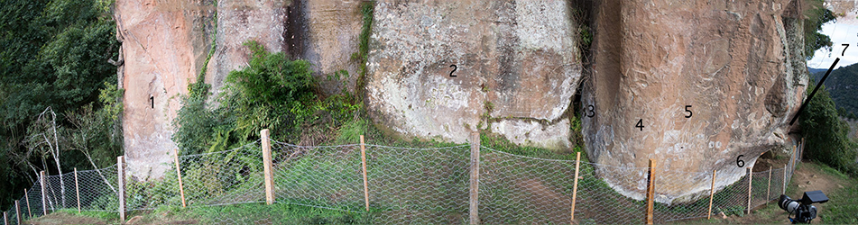
Avencal 1 is named for its proximity to and visual connection with the Avencal waterfall, located within a steep valley in the Urubici river catchment (Corteletti 2013, 52). The site is orientated on a north–south axis, facing east towards the sunset and opposite hillside. The total combined length of the rock face is approximately 40m, composed entirely of the local sandstone geology (Botucatu Sandstone formation). It is one of the most widely known rock art sites in the southern Brazilian highlands, owing to the variety and complexity of the motifs depicted (see Rohr 1971; Piazza and Prous 1977; Prous 1994; Da Silva 2001) and its status as a national heritage site. Documented motifs include human faces, animal and human figures, and a wide range of geometric engravings consisting of intersecting shapes, lines and dots (Rohr 1971). The apparent complexity of its content made the site an attractive location to evaluate the usefulness of PTM in this context (Figure 2).
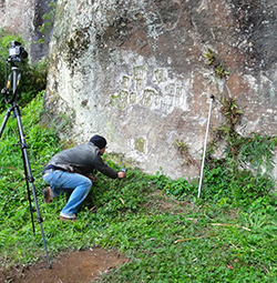
PTM is part of a larger family of computational photographic techniques collectively known as Reflectance Transformation Imaging (RTI), which were developed in 2000 by Hewlett-Packard Labs (Malzbender et al. 2001; Earl et al. 2010a, 2040). The process of data capture (Figure 3) involves employing a digital camera to take a sequence of images in which a subject is illuminated from varying angles, while it and the camera remain stationary. In our case, we employed a Nikon D1300 DSL with an 18-35mm kit lens and a Yongnou Speedlite YN560-II flash with remote triggers. The photographs, which must also contain a reflective sphere, are taken at a fixed f-number, exposure time, and ISO, and typically number between 40 and 80 per subject. This was recorded as associated metadata for each subject. The dataset is processed in specialised RTI Builder software to produce a single output file, whereupon the lighting of the subject can be manipulated at will from any angle on a 180° hemisphere. Surface normals can be extracted to gain an impression of shape (Figure. 4). Additionally, one of several mathematical enhancements may be applied to improve the appearance of shape and detail. This permits the perception of features that can be difficult or impossible to see under normal lighting conditions (Malzbender et al. 2000; 2001, 524-25; Earl et al. 2010a, 2042).
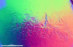
A PTM is also capable of revealing information about the shape of a surface which is too small to see, even under optimal conditions (see Earl et al. 2010b, fig. 1). Noted advantages of the technique are the relatively low cost of the equipment, and its speed of application and flexibility (Bryan and Chandler 2008; Earl et al. 2010a, 2044). In contrast to the bulk and high cost associated with laser scans, PTM generation requires only a digital camera, tripod, a reflective sphere, a flash unit, and a laptop, all comparatively cheap and lightweight items. This is especially relevant when conducting research in areas where work may entail overcoming considerable logistical barriers. The most time-consuming activity undertaken during the fieldwork that this article reports on was setting up the equipment for image capture. PTM also synergises with several pre-existing imaging techniques used in rock art research, such as photogrammetry and laser scanning (Earl et al. 2010b, 218-20).
As a photographic technique, PTM cannot arbitrarily discriminate between an engraved feature and its surrounding geology. In turn this means that, barring selective framing of the subject, the end-product is a representative and visually complete in situ record of the subject. Nonetheless, the limitations to angle of view and resolution of the equipment set-up described above required dividing the site into seven panels. As defined and referred to by us, the seven subdivisions of the site only served a heuristic purpose, and permit a straightforward discussion of the data. The result of this work was the creation of a total of 21 polynomial texture maps, representing almost the entirety of the known site, excluding two inaccessible engravings located approximately 5m above ground level on the north end (left side) of the panels. Throughout data collection we also aimed to include as great an area of the surrounding rock face as possible, so as to detect any subtle and potentially anthropogenic differences in texture or relief. We also applied the technique as a prospection tool on 'blank' panels in order to evaluate whether eroded or otherwise damaged petroglyphs could be detected in these areas.
View Panel 1a with WebRTIViewer
Internet Archaeology is an open access journal based in the Department of Archaeology, University of York. Except where otherwise noted, content from this work may be used under the terms of the Creative Commons Attribution 3.0 (CC BY) Unported licence, which permits unrestricted use, distribution, and reproduction in any medium, provided that attribution to the author(s), the title of the work, the Internet Archaeology journal and the relevant URL/DOI are given.
Terms and Conditions | Legal Statements | Privacy Policy | Cookies Policy | Citing Internet Archaeology
Internet Archaeology content is preserved for the long term with the Archaeology Data Service (ROR). Help sustain and support open access publication by donating to our Open Access Archaeology Fund.
File last updated: Tue Feb 3 2015