The urban focus of Etruscan archaeology predominates. Until recently most studies have focused on urban problems and consequently the archaeology of non-urban Etruria has been neglected. The archaeological history of the Etruscans, as currently written, is the history of individual city states interacting with one another and the city of Rome. The cities also interact with the wider Mediterranean world, particularly the Greeks. The one thing that the cities do not seem to interact with is the landscape of Etruria which they occupy.
The urban orientation of Etruscan studies so predominates that the largest and most important rural excavation yet undertaken, at Poggio Civitate, Murlo, has been interpreted as a meeting house for representatives of a league of northern cities (Phillips 1989, 79-83). The study of rural Etruria is not specifically excluded from Torelli´s vision of an archaeological history but it is not discussed within his interdisciplinary framework (Torelli 1987, 9-33). Up to the present, studies of the ancient landscape have yet to make an impact upon general Etruscan archaeology. This is quite remarkable since topographic studies have a long history in Italy dating from at least the beginning of the 20th century (Potter 1979, 1-9; Barker 1985; Barker 1987). Notably for Etruscan studies, field survey work started by J.B. Ward-Perkins in south Etruria in the early 1950s has discovered a continuum of ancient landscapes dating between the Bronze Age and the Medieval period. Detailed reports have regularly appeared in the Papers of the British School at Rome (e.g. Ward-Perkins 1955; 1968; Jones 1962; 1963) and the results have been synthesised in both English and Italian (Potter 1979; 1985). This work has inspired many other projects in Italy, and elsewhere (Keller and Rupp 1983; Barker and Lloyd 1991). Over the years, field survey has developed a series of methodologies to recover ancient landscapes and is now a well established technique (Haselgrove et al. 1985; Mattingley 1992). Only field survey can provide detailed information about the extent, form and development of a settlement system. However, more detailed investigation, by excavation, of individual settlements is often required to provide both dating evidence, in the form of pottery sequences, and economic evidence which can then be used to enhance the understanding of other rural sites discovered by survey (Potter 1979, 7-8).
Survey in south Etruria around Veii demonstrated that field survey could recover settlement patterns for the Etruscan period and provide a settlement history for the territory of southern Etruria which was not solely an account of urban history (Potter 1979, 52-92).
During recent years much new evidence has been collected by archaeological field survey from the Etruscan countryside (Barker 1988), which has not, as yet, become incorporated into general syntheses and interpretations (e.g. Rasmussen 1990; Perkins and Walker 1990; Perkins 1991; Barker et al. 1993). In the future this evidence will come to contribute to more general accounts of Etruria and the Etruscans. For the moment the most important observations to make are that field survey has established that there was a dense pattern of rural settlement which became established at the end of the 7th century, at the same time as the cities of Etruria began to flourish. This rural settlement was based upon cultivation of grain, vines and probably olives and the trading of agricultural surpluses. The precise nature of this rural settlement is only gradually emerging. In the 1920s when the archaeological map of Italy was being compiled the existence of small Etruscan settlement sites was not recognised. For example, the key to the Siena sheet (Bianchi Bandinelli 1927) has eleven different symbols for various types of tomb and none for a rural settlement. The nearest the key comes is ´rovine indeterminate´ (indeterminate ruins) or ´materiale sporadico´ poorly translatable as scattered material but closer to the English concept of ´stray find´. The same key is used for other maps covering Etruria. In this period Etruscan settlement was conceived of as consisting solely of cities and cemeteries. This lack of recognition of rural settlements caused interpretative problems when Bianchi Bandinelli (1925, 435-7) was assessing the distribution of tombs around Chiusi. He identified tombs more than 3km from Chiusi, which he considered to be too far from the city to be part of an urban cemetery, and he only identified one site which he considered to be a suburban centre (Bianchi Bandinelli 1925, 349). His interpretation of the pattern was that the location of the tombs was determined by the land holdings of urban patrician families and that the tombs were also used by their clients. Systematic survey has not been attempted in the region of Chiusi, but it would seem probable that there is a rural settlement pattern in the territory of the city, just as there is in all other areas which have been systematically investigated.
When large scale field survey work was conducted in South Etruria in the 1950s and 1960s, isolated Etruscan rural settlements were recognised for the first time. Over three hundred such sites were discovered in the various parts of the South Etruria Survey, yet even in 1979 Potter was direct enough to say ´None of these sites has been excavated and we know nothing of their layout, architecture or economic function.´ (Potter 1979, 76). Survey work in the Albegna Valley and Ager Cosanus also recognised an Etruscan rural settlement pattern but here the problem was addressed and the excavation of an Etruscan rural settlement at Podere Tartuchino was undertaken (Attolini and Perkins 1992).
Two seasons of excavations at Podere Tartuchino uncovered the remains of a substantial building with a large area of courtyard to the front. There were two distinct phases of building at the site. In the first phase of occupation, from the late 6th to the early 5th centuries BC, the farm was simply a single large room constructed of stone walls bound by clay, with a timber portico on the southern side (Attolini and Perkins 1992, fig.20)
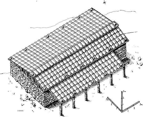
Fig. 2. Reconstruction drawing of Phase 1 of the farm at Podere Tartuchino (Attolini and Perkins 1992, fig.20). Drawn by S. Schafer
In the early 5th century the building was enlarged by the addition of two rooms to the west and one to the east; all of the pitched roofs were tiled with pantiles and canal tiles. At the same time the northern side of the courtyard was enclosed by a stone wall as protection against hill wash and rain water from the steep hill side (Attolini and Perkins 1992, Fig.22)
![]()
Fig. 3. Reconstruction drawing of Phase 2 of the farm at Podere Tartuchino (Attolini and Perkins 1992, fig.22). Drawn by S. Schafer
The large central room contained a hearth and a large pithos (ceramic jar) sunken into the beaten earth floor. This room appears to have been the centre of domestic activity in the farm. The pithos has been identified as part of a wine press, although other uses are also possible. Only further research will reveal whether this single farmstead is typical of all the sites given the classification ´house´ in the Albegna Valley/Ager Cosanus survey, let alone of all isolated rural settlements in Etruria but it provides a detailed and coherent example of what rural settlement in the valley was like. Recently a small site has been investigated at Pietriccioli, 5km east of Marsiliana (possibly site MAR91). Details are scarce but construction seems to be similar to that at Tartuchino, i.e. with rooms arranged around a large yard (Michelucci 1991, 346).