The Albegna Valley/Ager Cosanus survey grew from the excavation of a Roman villa at Settefinestre. The excavation was a joint Italian-British project involving many staff and students from a number of institutions. The excavation was co-ordinated by Professor Andrea Carandini (Carandini 1985b). Towards the end of the excavation it became apparent that, despite the remarkable results of the excavation, even the well preserved remains of a single villa could not provide a complete understanding of the regional Roman agrarian history. In order to broaden the base of evidence, some field survey was undertaken in 1977-8 in the Val d´Oro around Settefinestre (Carandini and Settis 1979, 35-7, 101-3; Celuzza and Regoli 1982, 60-1). In the following year this work was continued and the survey area was extended because the focus of the survey work had shifted from the villa at Settefinestre alone to include the whole territory of the nearby Colonia at Cosa, the Ager Cosanus. The north-western boundary of the territory has been reconstructed from medieval diocesan boundaries and natural features, such as the River Albegna up to the confluence with the Elsa (Cardarelli 1924-5, 17) and so the lower part of the Albegna valley was included in the survey area.
By the end of 1980 the survey had discovered sites from all periods and it was realised that a survey area defined by Roman territorial divisions would not be appropriate for all periods. Therefore the area to be surveyed was redefined as the geographical limits of the Albegna Valley including the coastal strip between the Rivers Albegna and Tafone. This area formed the smallest geographically coherent unit which fully contained the territory of Cosa, and it also contained the territories of two further Roman coloniae, Heba and Saturnia. This extension of the sample area raised the possibility of a comparison between the territory of Cosa and its neighbouring coloniae which could yield important results. Furthermore, this choice of survey area had the benefit of containing the widest possible range of geographical variation, from the source of the Albegna on Monte Labbro to the coastal plain. This expansion of the research aims of the project transformed the survey from the study of the context of a Roman villa to the survey of an entire region.
Systematic field survey of this entire area, over 1,000km², would have been impractical so a sampling strategy was devised to investigate a representative part of the area. The scheme chosen consisted of a 20% stratified sample of the land area of the valley. This consisted of a series of 1km wide transects regularly spaced through the area at intervals of 4km.
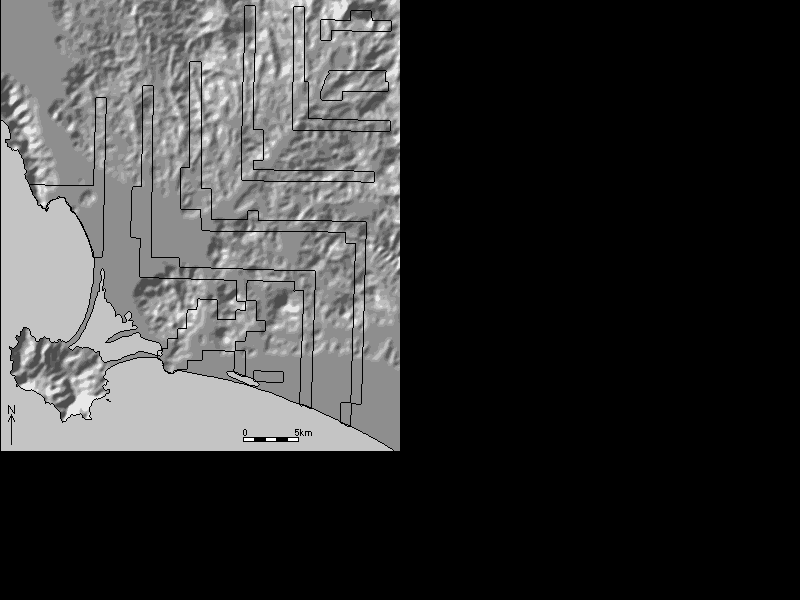
Fig. 4. Map of the locations of sample transects
The transects were arranged to run south from the northern watershed to the River Albegna and then turn through 90 degrees to run east to the eastern watershed. Where a transect met the watershed between the Albegna and the coastal plain it turned again to run southwards to the sea. This geometric scheme was particularly suited to the topography of the valley since the underlying geology causes affluents north of the Albegna to run north-south, while those south of the river tend to run east-west and those in the coastal plain run north-south. Thus the transects run parallel to the water courses. The position of the transects was carefully manipulated so that the regularly spaced transects covered parts of the sites of the Roman coloniae of Heba and Saturnia. This overall scheme was maintained throughout the duration of the project. Modifications were made to take account of various archaeological and geographical features, for example the transects were widened around the Etruscan and Roman urban centres so that the complete area of the settlements and their immediate environs were fully investigated, and areas of land reclaimed from lagoons in this century were avoided (Cambi and Fentress 1988, 169-72). In the upper reaches of the valley the ´L´ shaped transects were replaced with east-west transects, as sample areas parallel to the watercourses were impractical to survey as a result of the heavily dissected landscape. In addition, a block of 4km² around the Etruscan farm excavated at Podere Tartuchino, adjacent to a transect, was also surveyed to investigate the settlement pattern around the farm.
In 1980 a standardised system of recording surface scatters was developed to ensure that consistent information was recorded about each surface scatter. The system was based on that developed in the early survey work (Carandini and Settis 1979, 101-3, Panello 4). The system used is hierarchical. The primary item recorded by the system is a topographical location where archaeological material was found (Sito in Italian). This ´Sito´ (´situation´ is a better translation than ´site´) is identified by an abbreviated reference to a 1:25,000 Instituto Geografico Militare map sheet by a code of two or three letters: e.g. SD = San Donato, MAG = Magliano in Toscana followed by an integer e.g. SD23. The integer has no significance beyond being a unique identifier for the location, although in many areas the numerical sequence is coincident with the order in which the archaeological sites were identified. If required the location number was sub-divided into units to represent different spatial locations of surface scatters within the topographic location or chronological divisions discovered in the material. These sub-divisions are called UTs (Unità Topografica) and are represented as pseudo-decimals e.g. SD23.2. A location with only a single scatter or a single chronological period present is always presented with a UT of 0, e.g. SD23.0. This system of numbering is used throughout the pottery catalogue.
The record sheets for the surface scatters recorded details of the location of the scatter including a grid reference and access roads. The landform, geology, soil type, land use, vegetation and nearest water source were all recorded, along with a description of the finds, dimensions, dating, drawings and photographic records. In addition a topographic sketch of each scatter was made. A final category of information recorded was the method of field walking used, weather and light conditions, the time and date and the team responsible. In addition to the detailed descriptions of the locations where archaeological material was found, all of the fields walked, regardless of the presence of archaeological material, were recorded on the topographic maps.
In 1981 field walking of this sampling scheme began and intensive survey continued on an annual basis until 1986, when all of the samples had been systematically surveyed. The only area not covered was the mountainous northernmost transect which was not amenable to field walking because of topography and vegetation. Some areas outside of the transects were also investigated on a judgmental basis.