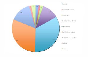
Of the 1082 catalogued objects 5% are Neolithic or Bronze Age; 12% are Iron Age or Romano-British; 79% are early medieval, incorporating Anglian and Anglo-Scandinavian finds; just 1% are medieval, and the remaining 3% cannot be assigned to a period (Figure 1).

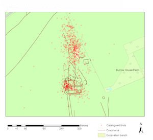
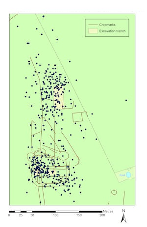
This clearly reinforces our impression of the extent of early medieval activity at Cottam B, compared with other periods. The proportion of Romano-British finds may well be under-represented as the database does not include any Romano-British pottery picked up during field-walking in 1989 and 1993. However, the Iron Age/Romano-British and medieval finds are still little more than a typical background scatter that might be expected in most fields in this region. Nonetheless, the patterning observable in the overall distribution of all those finds with geospatial coordinates (Figure 2) largely reflects the concentrations of early medieval finds, considered below, with a cluster of Romano-British finds towards the northern limit of the distribution.
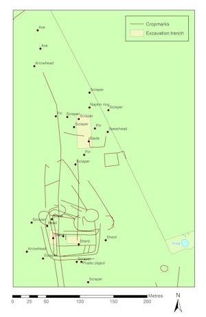
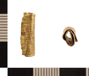
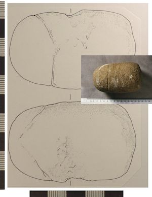
Although the number of Bronze Age finds is relatively small, it is worth highlighting the distribution as it may relate to activity on the site (Figure 3). The crop-mark evidence indicates a number of Bronze Age barrows in the area, and a sherd of Bronze Age pottery found during the excavation (Richards 1999a, 15), a gold bead (Figure 4), and a possible Bronze Age sandstone phallus (Figure 5) found close by, may relate to a ploughed-out cremation burial (Richards 1999a, 89). The circular ditch which, from the magnetometer survey plot, appears to abut the north-west corner of the enclosure could well be the ring ditch of this ploughed-out barrow. While it is impossible to determine if this was still an extant landscape feature in the 8th or 9th centuries AD, the juxtaposition of the two crop-mark features seems to be more than coincidence. A simple prosaic explanation that it provided some degree of shelter against the prevailing wind is possible, but the re-use of prehistoric features during the Anglo-Saxon period is now well attested (Williams 1997; Crewe 2012; Semple 2013). There are also examples of Anglo-Saxon execution sites re-using earlier barrows (Reynolds 2009) and given the evidence for a skull being fixed to a scaffold pole at Cottam in the 9th century (Richards 1999a, 93) it seems quite possible that the residual Bronze Age mound was used as an execution site.
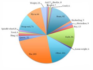
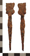
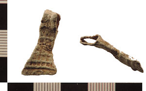
It is the early medieval finds themselves, however, that provide the focus for this article. Taking just the 851 early medieval finds, including those that could be designated specifically as Anglian or Anglo-Scandinavian, there are 20 artefact types for which there are five or more examples, with the largest categories being pins (183), hones (95), knives (86) strap-ends (71), and stycas (66) (Figure 6). There are also some significant individual finds that have been made since previous publications of the artefacts, including an iron stylus (Figure 7). This class of object was once thought to be exclusive to monastic sites, but examples have subsequently been found at other 'high-status’ sites (Pestell 2004, 40-8; Blair 2005, 210). Its identification at Cottam B extends this distribution further, and perhaps reinforces the suggestion that the site was used for the collection of dues or taxes, legal proceedings, or at least some function that would require a written record. Other new finds include one arm from a pair of tweezers of an unusual type, presumably of 9th-century date (Figure 8), and a miniature lead amulet in the shape of an axehead, probably Anglo-Scandinavian (Figure 9).

As already identified during the initial metal-detector survey, there are two clear concentrations of early medieval metalwork at Cottam B, and this distribution has been reinforced by the additional finds (Figure 10). The split between the two groups runs approximately along the 466800 northing and throughout this article this has been used to distinguish between a northern and a southern finds assemblage. The southern concentration coincides with the Butterwick enclosure, seen in the crop marks and geophysical survey (Richards 1999a, 9-10). The northern concentration was revealed through excavation to focus on an Anglo-Scandinavian farmstead, observed in the geophysical survey, but not generally visible in the crop-mark plot as the features were, on the whole, too shallow to affect crop growth (Richards 1999a, 94).
Internet Archaeology is an open access journal based in the Department of Archaeology, University of York. Except where otherwise noted, content from this work may be used under the terms of the Creative Commons Attribution 3.0 (CC BY) Unported licence, which permits unrestricted use, distribution, and reproduction in any medium, provided that attribution to the author(s), the title of the work, the Internet Archaeology journal and the relevant URL/DOI are given.
Terms and Conditions | Legal Statements | Privacy Policy | Cookies Policy | Citing Internet Archaeology
Internet Archaeology content is preserved for the long term with the Archaeology Data Service. Help sustain and support open access publication by donating to our Open Access Archaeology Fund.