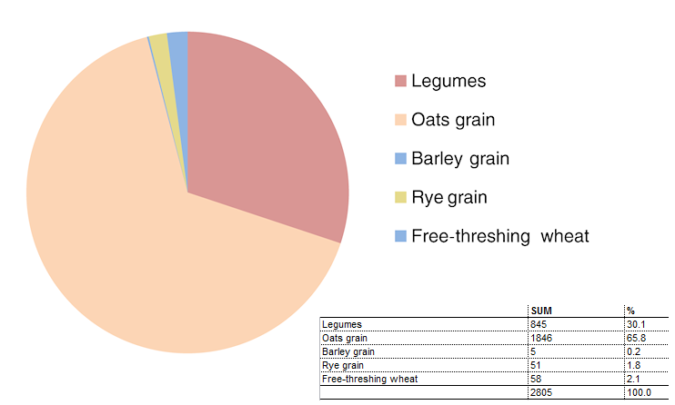
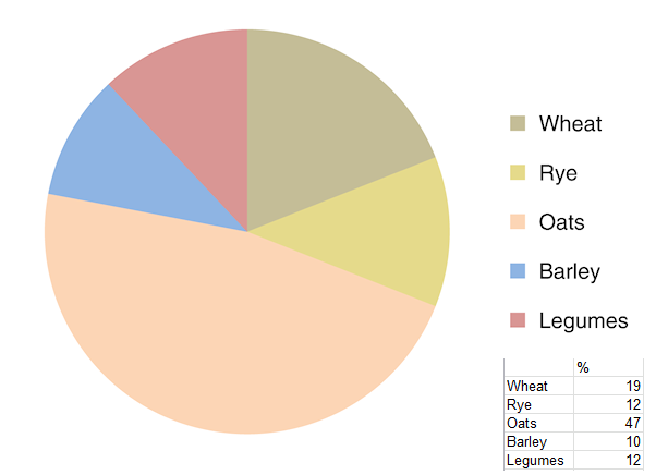
The crops found stored in the farmhouse appear to be typical of those grown in the area at the time. Records of crops grown on demesne lands in the 13th and 14th centuries in the Exeter region show spring-sown oats to have been the most common crop (varying between 47% and 82% of cultivated land) with winter-sown wheat at between 4% and 27%, and rye not dissimilar (Hallam 1988, fig. 4.21). In the manor of Otterton in 1324–25, barley (10%) and legumes (12%) are also recorded. The proportions of different crops from Otterton show that the burnt store at Island Farm contained a close representation of the crops in that particular manor (Figures 15a and 15b) and suggests that this may have been typical of the East Devon region. It further suggests that the crops cultivated by ordinary farmers were similar to those cultivated by lords.
A further observation comes from the records of grain ground at manorial mills in the late 13th century, where the figures from Exminster and Tiverton include large quantities of maslin (wheat-rye mix) (Hallam 1988, fig. 4.22). The Island Farm evidence corroborates that maslin was an important product, and furthermore probably one grown, harvested and stored as a crop in its own right, rather than being a blend of separate harvests.
The immediate context of the medieval longhouse at Island Farm is not known. No other remains of this period have been found in the vicinity, and it appears to have been an isolated farmstead. However, although no associated structures were located, it is possible that barns and outbuildings with non-earthbound foundations, and therefore leaving little or no archaeological trace, lay nearby. The manor of Ottery St Mary is recorded in AD 963 and the core of the medieval village lay some 800m to the north-east. The modern landscape is classified as one of 'Barton fields': large, regular enclosures laid out in the 15th to 18th centuries (Turner 2007, 60–8; Devon Historic Environment Record in Cotswold Archaeology 2011). The fields on the site may have been laid out in alignment with the medieval open field on the higher land to the west, while the floodplain to the east apparently lay largely unmanaged until drainage schemes in the 18th to 19th centuries (Cotswold Archaeology 2011). Two nearby farmsteads, Salston Barton, 250m to the south, and Thorne Farm, almost equidistant to the north, each have medieval origins (DHER refs 16945 and 16943; Cotswold Archaeology 2011). All three lie on the edge of the river terrace and may be indicative of a pattern of medieval farms sited to take advantage of upland and floodplain resources.
Internet Archaeology is an open access journal based in the Department of Archaeology, University of York. Except where otherwise noted, content from this work may be used under the terms of the Creative Commons Attribution 3.0 (CC BY) Unported licence, which permits unrestricted use, distribution, and reproduction in any medium, provided that attribution to the author(s), the title of the work, the Internet Archaeology journal and the relevant URL/DOI are given.
Terms and Conditions | Legal Statements | Privacy Policy | Cookies Policy | Citing Internet Archaeology
Internet Archaeology content is preserved for the long term with the Archaeology Data Service (ROR). Help sustain and support open access publication by donating to our Open Access Archaeology Fund.