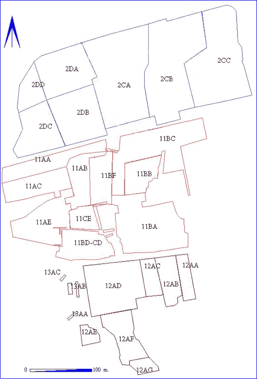
Fig. 2.8 West Heslerton: Anglian settlement excavation areas
The settlement area covers four 'Sites' as defined by modern field boundaries - Heslerton Parish Project Sites 2, 11, 12 and 13, covering respectively the northern, central and southern areas of the settlement. In each site the excavation was undertaken in a number of arbitrarily defined areas, each identified by a two letter code (Table 2.1 and Fig. 9).
Although Site 2C was stripped in 1986, major excavation did not begin until 1987 as it was felt, and indeed proved to be the case, that a winter of weathering and exposure to the air made the features easier to identify and the fractured chalky areas easier to clean. Work in 1986 was concentrated on a few sample areas to assess the nature of the deposits, and those where the features were cut into chalk gravel. During 1987 and 1988 work was concentrated on Site 2 Areas CA-CC, in 1989 in Areas 2DA-2DD, in 1990 Site 11 Areas AA-AE, in 1991 Site 11 Areas BA-BF, and in 1992 in Areas 11CE and 11CD which it had not been possible to complete in the previous year. During 1995 work was completed with the examination of large areas of Site 12 and three small sample trenches in Site 13.
| Year | Area |
|---|---|
| 1986 | small sample areas |
| 1987 and 1988 2CA-2CC | 36,500 sq.m. |
| 1989 Areas 2DA-2DD | 20,500 sq.m. |
| 1990 Areas 11AA-11AE | 19,500 sq.m. |
| 1991 Areas 11BA-11BC | 20,600 sq.m. |
| 1992 Areas 11CD,11CE | 6,000 sq.m. |
| 1995 Sites 12 and 13 | 22,000 sq.m. |

Fig. 2.8 West Heslerton: Anglian settlement excavation
areas
© Internet Archaeology
URL: http://intarch.ac.uk/journal/issue5/westhes/2-6-4.htm
Last updated: Tue Dec 15 1998