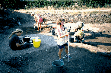
Fig. 2.13 Recording finds locations with the EDM
The computerised recording system, developed to good effect on the Heslerton Parish Project Site 1 and cemetery excavation, formed the core of the archaeological record (Powlesland et al. 1986). Hand-held computers were used in the field in conjunction with conventional site notebooks into which the computerised records could be pasted; objects were individually referenced and their primary records likewise generated in the field. The computerised records and notebooks were accompanied by field drawings at a variety of scales, photographs in monochrome and colour and occasionally by video.
Fig. 2.13 Recording finds locations with the EDM
An electronic distance meter (EDM or Total Station) was used to record artefact, sample and context locations. This was seen as an essential component of the recording system.
CAD packages have been used to assist in the production of drawings, with the objective of producing a complete three dimensional plan of the site to form the basis of the publication drawings. In addition, at c.15ha., the site is very large and the potential for spatial analysis was seen at the outset to be of fundamental importance.
Both the record structures and the recording systems as a whole were designed to satisfy a number of different needs. The key consideration was that the data should be readily analysable and that the record as a whole should facilitate rapid publication. Excavations on the scale of West Heslerton have tended in the past, often understandably, to enter long periods of gestation after the fieldwork has been completed, the reports appearing long after the fundamental impact of the site has been absorbed. As the excavation continued, new developments in computer applications were taken on board and the overall recording system refined in keeping with the primary aims of the recording strategy. This work, for which both the hardware and software were funded from external sources and sponsorship, has earned the project and its staff a considerable international reputation and has resulted in numerous lectures which describe the combination of methodology and results; these have been given in Britain, Northern Europe and North America. The work programme has also fulfilled a generalised experimental objective that large projects such as West Heslerton should provide a good context for the development, testing and refinement of field methodologies.
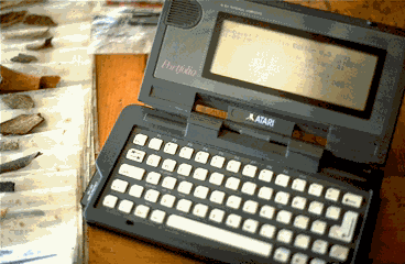
Fig. 2.14 Hand-held computer used for recording in the field
The record structures used at West Heslerton were initially designed in conjunction with the North Yorkshire County Planning Department as a component in the Sites and Monuments Record for the county. Following their use with a pro-forma system on Site 1, the structures were redesigned to facilitate entry using hand-held computers, the record structures themselves remaining unchanged until the 1992 session of work was completed. All data were originally stored in a binary relational database developed by the project director; the system proved fast and powerful on what now seem like antique computers, but the database lacked flexibility and any changes to data structures or new records required detailed attention by the project director. It was therefore decided in 1991 to change over to an Xbase database which would require less dedicated programming and, although much slower, offered greater potential within the post-excavation environment, in which many new records and structures would be needed in addition to a simple mode of data exchange with the specialists. The on-site records continued to be collected in binary form either on hand-held computers or through transcription to a PC in the site office, the data subsequently being translated to Xbase files to be used with FoxPro for Windows and Access databases.
The primary files are composed of the Context Record, the Object Record, the Flotation Record, the Drawing Register, and the Photographic Record, the latter having received the least attention. The primary key which links all the records is a combined field comprising the Site + Area + Context [+Object Code], the context record having a one-to-many relationship to all the other files. The use of many data fields incorporating numeric codes was a feature of the original system which, besides maximising on disk storage space, encouraged a high level of uniformity in the record. There was only minimal space for free text in the computer records in which attention was focused on factual data that was well suited to analysis; additional information remains written as notes in the many site notebooks. Both of the principal records, the Context and the Object records, require expansion as part of the post-excavation process to incorporate additional phasing information in the Context records and to give additional details concerning weight, rim-diameters, sherd-joins etc. in the Object records.
The basic structure comprised a relational database with two primary files, the Context Record and the Object Record, with a large number of supporting code files that facilitated entry of coded information which required less storage than free text. This was felt to be suitable for analysis and quick retrieval during the fieldwork phase and ensured a degree of record compatibility between recording staff. A basic assumption within the record structure is that deposits and features should wherever possible be classified in the field rather than described simply as positive and negative features; needless to say, there are still numbers of features where there is some doubt as to their function and, although the context type is a primary field this should not hinder the analytical process. Currently a number of different databases incorporate both the core data extracted for, and that provided by, specialists, particularly the animal bone.
| Context Record | Object Record | Environmental Rec.(Flot Data) | Drawing Rec. | Photographic Rec. | |||||
|---|---|---|---|---|---|---|---|---|---|
| 19,500 | 98,000 | 3000+ | 18,500 | 22,000 | |||||
| FIELD NAME | LEN | FIELD NAME | LEN | FIELD NAME | LEN | FIELD NAME | LEN | FIELD NAME | LEN |
| KEY_ID | 10 | KEY_ID | 10 | DATE | 8 | SITE | 3 | FILM_TYPE | 2 |
| MASTER | 10 | SITE | 3 | SITE | 3 | AREA | 2 | FILM_NO | 3 |
| SITE | 3 | AREA | 2 | AREA | 2 | CONTEXT | 5 | YEAR | 2 |
| AREA | 2 | CONTEXT | 5 | CONTEXT | 5 | CONTEXTTYP | 15 | FRAME | 2 |
| CONTEXT | 5 | RT | 1 | OBCODE | 2 | SHT_SERIES | 2 | SHOT_TYPE | 13 |
| PERIOD | 16 | OBCODE | 2 | TAGNUMBER | 7 | YEAR | 2 | QUALITY | 1 |
| TYPE | 16 | PERIOD | 15 | BLOCKNUM | 3 | SHEET | 4 | DESCRIPTIO | 30 |
| SHAPE | 16 | MATERIAL | 15 | PROCESSBY | 3 | DTYPE | 1 | SITE | 3 |
| XCOORD | 6 | TYPE | 16 | VOLUME | 4 | FACING | 6 | AREA | 3 |
| YCOORD | 6 | SUB_TYPE | 16 | VOL_STONE | 4 | MASTER | 1 | Ctxt. 0 | 5 |
| ZCOORD | 5 | CLASS | 16 | VOL_SAND | 4 | SCALE | 3 | Ctxt. 1 | 4 |
| LENGTH | 5 | XCOORD | 6 | NOTES | 50 | DRAWN_BY | 3 | Ctxt. 2 | 4 |
| BREADTH | 5 | YCOORD | 6 | BONE | 1 | EDM | 1 | Ctxt. 3 | 4 |
| DEPTH | 5 | ZCOORD | 6 | POT | 1 | TRANS | 1 | Ctxt. 4 | 4 |
| ALIGNMENT | 16 | TAGNUMBER | 6 | LMWEIGHT | 1 | DIGI | 1 | Ctxt. 5 | 4 |
| POSITION | 16 | ELEMENT | 11 | WORKEDFLIN | 1 | COMMENTS | 15 | Ctxt. 6 | 4 |
| AGE | 16 | CONDITION | 15 | C_SEEDS | 3 | XCOORD1 | 6 | Ctxt. 7 | 4 |
| PROFILE | 16 | ALTERATION | 15 | CHARCOAL | 3 | YCOORD1 | 6 | Ctxt. 8 | 4 |
| SOILTYPE | 16 | NUMBER_OF | 4 | SNAILS | 3 | ZCOORD1 | 5 | Ctxt. 9 | 4 |
| SOIL_TEXTR | 16 | MAN_TECH | 15 | SESAME | 3 | XCOORD2 | 6 | Ctxt. 10 | 4 |
| MUNSELL | 6 | DEC_TECH | 15 | RECOVERY | 3 | YCOORD2 | 6 | Ctxt. 11 | 4 |
| FILLOF_ABO | 5 | FINISH | 15 | PH | 4 | ZCOORD2 | 5 | Ctxt. 12 | 4 |
| SEALED_BY | 5 | INC1 | 15 | SMPL_AREA | 3 | CHECKED_BY | 3 | Ctxt. 13 | 3 |
| CUTS_INTO | 5 | INC2 | 15 | RETURNED | 1 | Ctxt. 14 | 3 | ||
| PRIM_FILL_ | 5 | INC3 | 15 | X_COORD | 6 | Ctxt. 15 | 3 | ||
| STRAT1 | 6 | INC4 | 15 | Y_COORD | 6 | Ctxt. 16 | 3 | ||
| STRAT2 | 6 | CONT | 2 | Z_COORD | 5 | Ctxt. 17 | 3 | ||
| STRAT3 | 6 | RECBY | 3 | Ctxt. 18 | 5 | ||||
| STRAT4 | 6 | DATE | 10 | ||||||
| STRAT5 | 6 | ||||||||
| STRAT6 | 6 | ||||||||
| STRAT7 | 6 | ||||||||
| NOTES | 150 | ||||||||
| M_PLAN | 1 | ||||||||
| D_PLAN | 1 | ||||||||
| SECTION | 1 | ||||||||
| C_PHOTO | 1 | ||||||||
| M_PHOTO | 1 | ||||||||
| VIDEO | 1 | ||||||||
| POTTERY | 1 | ||||||||
| AN_OS | 1 | ||||||||
| HUM_OS | 1 | ||||||||
| OBJECTS | 1 | ||||||||
| BUILD_DEB | 1 | ||||||||
| OTHER | 1 | ||||||||
| C_14 | 1 | ||||||||
| SEED | 1 | ||||||||
| POLLEN | 1 | ||||||||
| SNAIL | 1 | ||||||||
| ORGANIC | 1 | ||||||||
| CONT | 1 | ||||||||
| QUALITY | 16 | ||||||||
| METHOD | 16 | ||||||||
| REC_BY | 3 | ||||||||
| WHEN | 10 | ||||||||
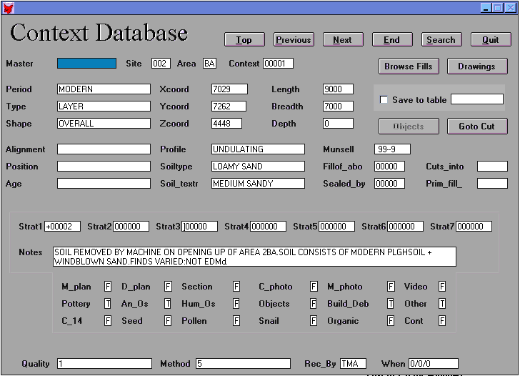
Fig. 2.15 Context record
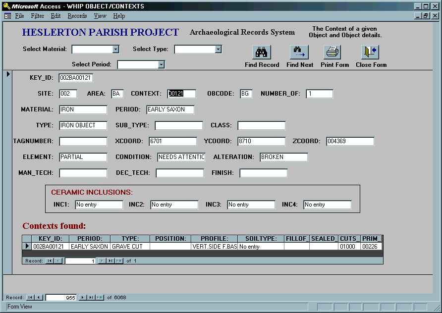
Fig. 2.16 Object record
© Internet Archaeology
URL: http://intarch.ac.uk/journal/issue5/westhes/2-6-9.htm
Last updated: Tue Dec 15 1998