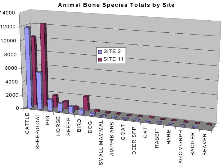
Fig. 3.31 West Heslerton: animal bone frequency by species and site (identified material)
West Heslerton has produced the largest body of environmental data from any site of the period; over 3,000 flotation samples and several hundred thousand fragments of animal bone. Although the potential was originally thought to be limited, the recovery of large plant macrofossil, charcoal and faunal assemblages offer the opportunity to investigate the agrarian economy of an Early Anglo-Saxon community within its landscape; this has not previously been possible given the paucity of evidence from any other site. Despite the dry and abrasive nature of the deposits, large quantities of carbonized seeds provide the basis for a reconstruction not only of the products of agriculture but also, through the examination of weed and seed assemblages, serve to identify in broad terms where the crops were grown. Only in the case of land snails and pollen was survival so poor as to preclude useful analysis, although within close proximity good pollen data does survive which might form the basis of a separate contextual landscape study.
In every respect, the quality and potential of the environmental data matches that of the other classes of data from the site.
Difficulties in precise phasing and the clear separation of Roman, Early and Middle Saxon contexts require the full integration of the environmental data as a component in the definition of the principal phasing groups. When examined as part of an integrated research programme, the evidence points towards a hitherto unanticipated degree of land and crop management, in which woodland management and orchards play as important a part as the raising of sheep for wool, or cattle for traction and for milk. Exotic domesticated species amongst the faunal assemblage include hunting dogs and birds of prey, which add a social dimension to the data that would perhaps have remained invisible in a smaller data-set. In each aspect of the environmental research, there is an intrinsic value in comparing the data from West Heslerton with both later and earlier sites locally. The quality and scale of the data, coupled with the detailed and spatially precise record, provide a unique opportunity to test and answer questions of both local and national significance.
The mix of deposits derived from a variety of different parent materials and the variation in deposit types, including sealed surfaces as well as well-sealed features, coupled with the 3D recording system employed, offer potential for detailed intra-site analysis, for the examination of disposal practices, fragmentation and site formation and deformation processes, that are relevant to a broad spectrum of other sites both in the rural and urban setting.
The large data-set available from West Heslerton must be viewed within the regional and national context, and as such offers a tremendous opportunity for comparative analysis with the data from York in particular. The opportunity to compare and contrast the urban and rural assemblages should not be lost. Admittedly, if clear separation of the Roman, Early Anglo-Saxon and Middle Saxon contexts cannot be established, then this potential may not be realised.
Fig. 3.31 West Heslerton: animal bone frequency by species and site
(identified material)
The huge assemblage, more than half a million pieces, of animal bone derived from the site forms a nationally important data-set in its own right. The extent of the excavations and the three-dimensional recording of all finds using geographical software provide a rare opportunity for intra-site spatial analysis. Although the abrasive nature of the soils on much of Site 2 and the use of heavy plant and machinery for site stripping meant that the frequency of recent breaks was fairly high, recovery rates were good, with a high percentage of the smaller bones recovered. The extensive flotation programme which covered features throughout the site has provided a reference data-set with which recovery and survival statistics can be calculated in detail.
The faunal assemblage includes a number of unusual and large subgroups which offer particular opportunities for new research. A total of 143 articulated skeletons and limbs (recovered prior to 1995) have been identified in the assemblage, and, unusually, allow examination of complete skeletons as opposed to the wealth of fragmented material more commonly generated as food waste. The articulated skeletons include dogs, cattle, horse, sheep and goats. A large number, over 3,000, of bird bones provide the potential to examine questions regarding the use of birds of prey for hunting and the role of fowl in the diet. They occur more frequently in the southern part of the site and may either be a product of differential survival or, alternatively, may be an indicator of social status. The precision of the spatial record is such that we are in an excellent position to compare and contrast the data from this site on a feature by feature and an area by area basis; this is essential if we are to examine the differences that are manifest in the structural remains of the site, with areas each apparently serving different but quite specific functions. The large quantity of material from well-stratified contexts, formed within a comparatively short time-span with minimal residuality and contamination over much of the site, makes the assemblage unique. At the southern end of the site, where the late Roman occupation has been identified, particular care will be required to identify those contexts that are undeniably Roman, as the comparison between Late Roman/Early Saxon/Middle Saxon agrarian and stock management will clearly be an important aim in the analysis of these data. If, as appears to be the case, the settlement was established in the Late Roman period, a full understanding of the continuity of population and economy must be established.
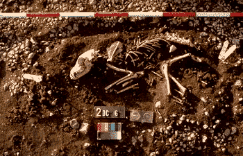
Fig. 3.32 Dog burial cut through a worn pebble surface
Preliminary analysis by David Berg indicates differences in the faunal material from area to area. The examination of the faunal material in tandem with the other environmental and economic data will provide a more detailed understanding of the land-use and economy of a Late and immediately Post-Roman community than has ever before been possible.
The recovery methods employed on site were designed to provide the maximum analytical potential, including the potential to examine aspects of deposition, disposal, fragmentation, formation and deformation processes. The scale of the project and the detailed resulting database offer opportunities to examine issues such as recovery practices in a way that is not possible with less well spatially referenced data, and provide a data resource that will allow us to investigate potentials within field methodology. This is particularly the case with the faunal assemblage, a large percentage of which comprises 'non-zoned' material; scraps, chips and splinters of bone that are only broadly identifiable. Individually this material is of no interest. As a large and spatially referenced data-set, however, derived from a wide variety of depositional environments, in functionally distinctive settlement zones, this material offers an opportunity to address matters of optimal recovery. This material can be subjected to digital re-sampling, trend surface and comparative analyses, which may help in defining future strategies for animal bone recovery. The application of a variety of recovery techniques ranging from bulk extraction by hand, or fine wet sieving as part of the flotation process, to individual fragment plotting will enable us to review this aspect of the recovery process in addition to the very clear benefits derived from the analysis of the 'zoned' species and part identified section of the assemblage. Aspects of fragmentation and secondary change to the faunal assemblage through such activities as ungulate gnawing are good pointers towards establishing the pattern of land-use within the settlement area as a whole. The 'non-zoned' material simply requires basic data entry to enable a link to be established with the spatial reference database to permit this spatial analysis to take place. The very detailed assessment of the material provide by David Berg reflects the degree of work already completed, but also the quality and potential of the data-set (see also 4.3 Faunal Remains Assessment)
Just under 3,000 flotation samples were taken on site for the recovery of plant macrofossils, charcoal and small bone fragments; 5% of these samples were examined by Wendy Carruthers for this assessment. Further work undertaken by Steven Mrozowski and funded independently has concentrated on the detailed examination of material related to a malt kiln and from three of the Grubenhäuser. Most of this material was derived from the Grubenhäuser which were given a priority in the flotation programme because of the need to assess their function both during and after active use, and the relatively uncontaminated and single period nature of their fills. Following initial experiments where the entire fills of three of these features were floated in 0.20m square blocks per layer, the remainder were sampled by floating the baulks, once again in spatially referenced blocks, providing an environmental cross-section of the filling of these features.
Recovery rates for plant macrofossil evidence were far higher than was suggested might be possible at the beginning of the project. Although some waterlogged deposits were encountered around the spring pool at the southern end of the site, they proved less commonplace than had been hoped for and the sample collected comprises almost exclusively carbonized material. The single waterlogged sample examined in Wendy Carruthers assessment indicates that the recovery of further waterlogged deposits in the future offers considerable potential. Flax seeds identified in the sample are important, given the importance given to textile manufacture in the literature relating to the period. There was only minimal indication of contamination. The assemblage, although dominated by cereal remains, includes a broad range of taxa, including arable weeds, indicating that the main cropping area lay to the north of the settlement on the light sandy soils between the settlement and the wetland associated with the fenland deposits in the centre of the valley. The presence of heather indicates the import of plant materials from moorland which is some distance away.
The large number of samples from this site, their spatial distribution, multiple samples from single large contexts and precise location data provide good potential for detailed assemblage analysis. Through the examination of plant communities, aspects such as the range and distribution of habitats being exploited can be examined in some detail, the samples from the Grubenhäuser alone offering a unique opportunity for intra-site analysis. There is evidence from the seed remains to indicate that one function of these structures is likely to have been as grain-storage buildings. Detailed examination will be required to determine if grain storage structures had a particular distribution, as at present it appears. Once a more detailed phasing can be established then we have a unique opportunity to examine temporal change. The importance of this assemblage cannot be overestimated, since it remains by far the largest and best documented from any site of this period, the two other major settlement excavations from this period having produced almost no environmental evidence at all. The assessment of this material has identified variations in weed distributions that indicate functional differences from one part of the site, and add some weight to the argument that the enclosure at the centre of the site (11AB) was primarily utilised for agricultural processes.
The relationship between arable and pastoral agriculture and the associated land-use can here be examined in some detail, given the large assemblages of other environmental data. Clearly the quality and quantity of data recovered deserve detailed examination, as it provides the opportunity to bridge the gap between the relatively well known periods that precede and follow the occupation at West Heslerton. The need for spatial and integrated analysis has been raised throughout the assessment documents, with the plant macrofossil evidence offering perhaps the greatest potential for identifying differences from one area to another. The role of the Grubenhäuser as rubbish disposal features following their abandonment as active structures provides particular potential for the examination of formation and deformation processes. Richard Macphail has identified extensive bioturbation in the fills of these features, indicating a high organic content; only through careful examination of the environmental evidence will we be able to paint a realistic picture of the post-structural use of these features and the decay of the site. Further work is needed to identify the broader species diversity relating to diet, as is indicated both by the identification of a number of stones from fruit and berries, and the fruitwoods identified in Isobel Figeural's examination of the charcoal (see also 4.2 Charcoal Assessment).
Although individually recovered charcoal samples retrieved by hand in the field and containing large fragments represent less than 500 samples, charcoal was present in almost all the floated samples. A small selection, just under 1,000 fragments, derived from all areas of the site were examined to determine the potential for a more detailed analysis of this material. The samples were once again described as exceptional. From the very limited examination that was possible from the resources available, it is quite clear that the charcoal offers great potential for the reconstruction of aspects of the broader landscape and economy of the West Heslerton community. The two most common taxa were oak and hazel, oak being most likely to be the principal material used in the major building timbers. The frequency of hazel is important, given that the name 'Heslerton' translates from the Anglo-Saxon as the 'village in the hazel woods'. The evidence recovered demonstrates that woodland management was taking place and that some degree of orchard cultivation must have been taking place, given the relative abundance of fruit woods amongst the charcoal. Heather and gorse were present in quantities confirming that materials were being introduced to the site from some distance, and that moorland environments were already well established. The detailed examination of the spatial distribution of this material deserves study as the quantities present and condition indicate that the material was being gathered at all times of the year and may have served an important role in the structures, perhaps as a roofing material. The broad range of habitats represented in the charcoal and plant macrofossil evidence demonstrate the level to which the landscape was both managed and exploited, a picture that broadens further when we consider the presence of wild-fowl and deer amongst the faunal material (see also 4.1 Plant Macrofossils and 4.2 Charcoal Assessment).
The difficult soil conditions encountered on this site, and the need for detailed evidence to assist in the examination of site formation and deformation processes, made the collection of samples for soil micro-morphology particularly important. The work undertaken by Richard Macphail on site, and that by Maureen McHugh on the hinterland, have addressed both detailed feature-specific questions as well as broader issues relating to the development of the landscape and the human impact upon it from the prehistoric period onwards.
The potential offered by the pedological studies to provide a broad sequence for the landscape development, and in particular the results of increasing agricultural exploitation, should not be discounted. Thirty-five samples were prepared and examined both during the progress of the project and in order to contribute to this assessment, a further ten samples were retained for additional examination if required. The potential offered through soil micro-morphology for the broader reconstruction of the pedological sequence in the immediate area of the site has been substantially satisfied. It has provided some insight into the transition of the landscape, with increasing agricultural exploitation during the later prehistoric period and an intensification and broadening during the Roman period, giving rise to an increase in colluvial activity at the base of the Wolds scarp. The build up of colluvial deposits derived from the dry-valleys running out from the Wolds was evidently rapid during the Roman and immediately succeeding period, perhaps as a consequence of woodland clearance and breaking in of new ground for agriculture. The build up of colluvium within the settlement sequence offers great potential for detailed examination of localised land-use at the macro level, and this is borne out by Richard Macphail's examination of deposits against the southern limit of the excavation. A remarkably detailed picture of the development sequence associated with the enclosures in area 11BA to the east of the spring indicates that some of the enclosures served as stock enclosures, perhaps only on a periodic or seasonal basis. The picture that has emerged owes much to the preservation of an enhanced soil profile within a broad natural gully running out from the foot of the Wolds, the majority of which lies in the unexcavated area to the south. The identification of interleaved layers of heavily manured colluvium, ashy and midden deposits, indicate that, should further work take place to the south, this broad gully, with plough-damaged chalk ridges on either side, offers the potential for a well-preserved stratigraphic sequence documenting in detail the transition from the Roman to Saxon periods.
Most of the thin-section work was concentrated on the detailed examination of the fills within the Grubenhäuser. The frequent identification of phytoliths and other evidence of decayed organic waste may be a major contributing factor towards the formation of a characteristic tripartite fill sequence observed in many of the Grubenhäuser. The suggestion that in some the primary fill may have been substantially made up of organic waste, deserves detailed examination to determine whether this may have been either the residue of thatch and other building materials left over after the dismantling of the superstructure, or a deliberate deposit. Higham has suggested that Tacitus describes Grubenhäuser as root cellars in the Germanic homelands, although there is little in the way of corroborative evidence (Higham 1991).
The presence in many of the samples of daub fragments is important, although this needs further analysis to allow for detailed quantification. Burnt daub was rare over most of the site and there is little other evidence to suggest how extensively it was used in the building walls. The frequent identification of cess and the presence of a number of coprolites and coprolite fragments in the fills of the Grubenhäuser demonstrate their ultimate use for the disposal of domestic waste.
Clearly the thin-section programme has borne good results; however, the detailed interpretation of the soil micro-morphology deserves careful integration with the results of the other environmental analysis if we are to get the greatest benefit from this work (see also 4.4 Assessment of Soils).
© Internet Archaeology
URL: http://intarch.ac.uk/journal/issue5/westhes/3-8.htm
Last updated: Tue Dec 15 1998