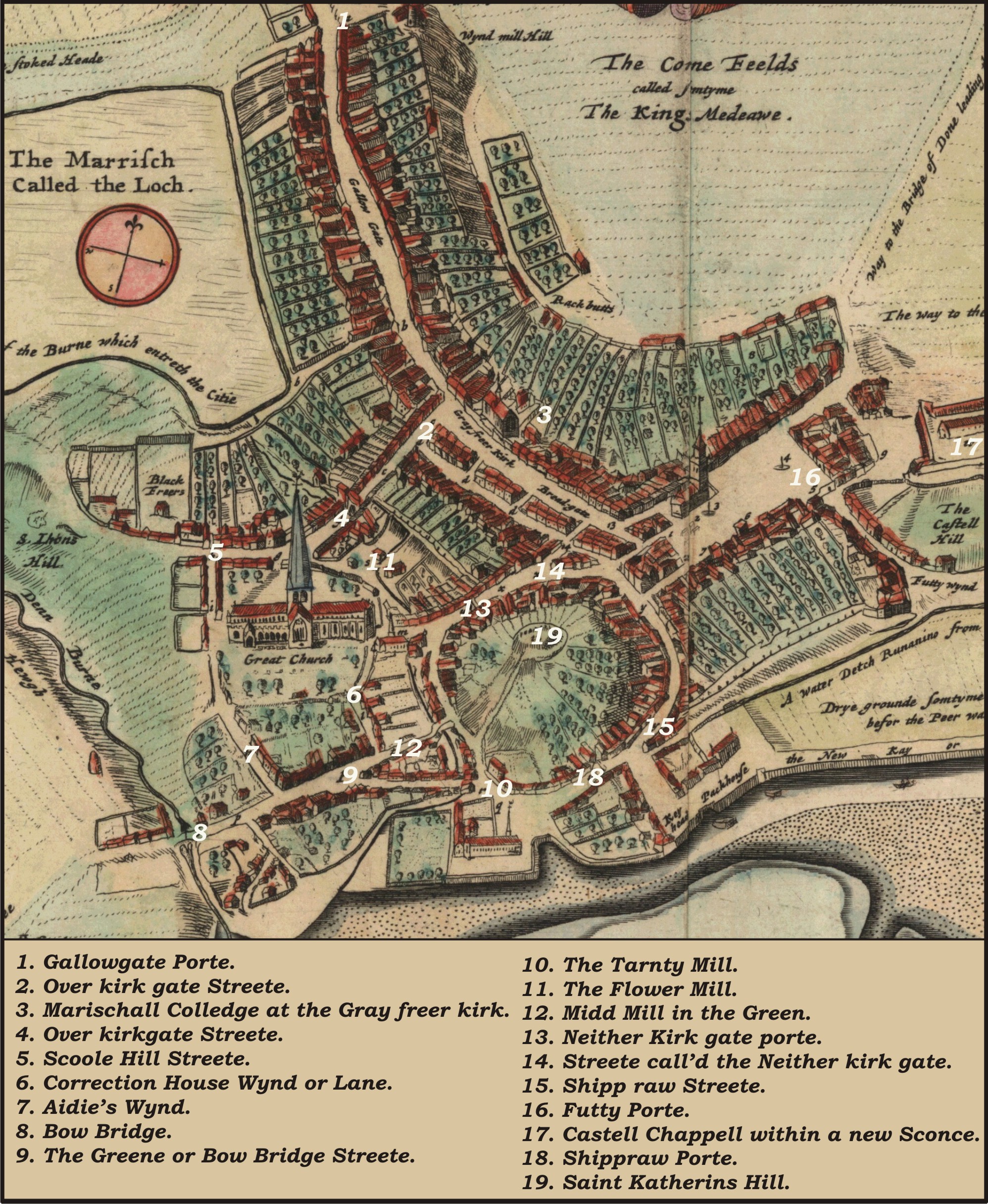
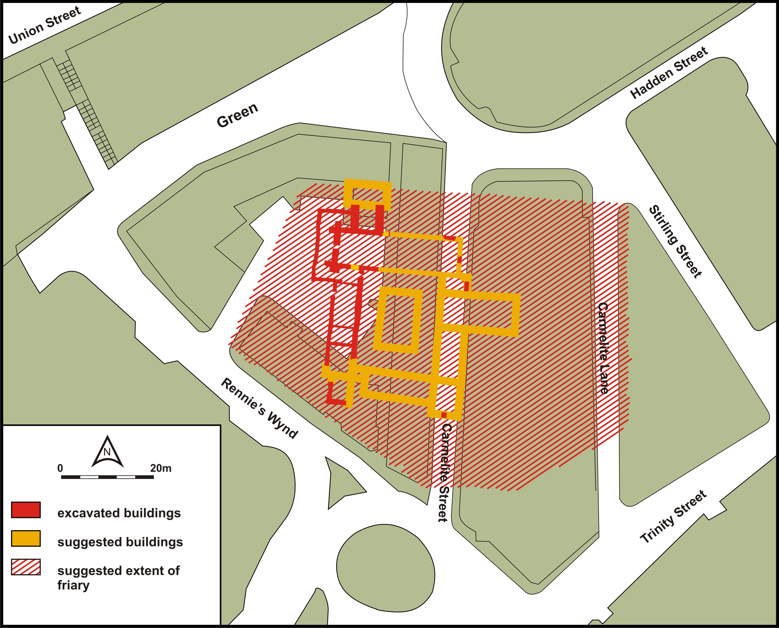
After the various and tortuous transfers, the lands of the Carmelite friary (along with those of the Blackfriars) passed into the hands of the Earl Marischal (Anderson 1909, 105-8). The Earl Marischal used the lands of the Black and White friars to endow his newly founded college (Anderson 1909, 109-111 and Anderson 1889, 1-39). The lands remained with Marischal College for the next three hundred years and formed a useful part of the income of that college. The policy that Marischal followed was to lease out the land in the Green. It seems that for a large part of the time that the lands belonged to Marischal College, they were feued out for largely agricultural purposes. This was never explicitly stated but can be seen from evidence in the later eighteenth century, and from evidence derived from Parson Gordon's map (Figure 8) and description of Aberdeen. It was only in the eighteenth century that this policy changed and stances for new houses were laid out on the friary lands, and the modern street layout of Rennie's Wynd and Carmelite Street and Lane was formed (Figure 10).
There are many entries concerning the lands of the Whitefriars that subsequently appear in Marischal College records. The principle sources are the volumes of College Rentals and Accounts. In Principal Howie's Rental of 1598 there is a considerable amount of information:
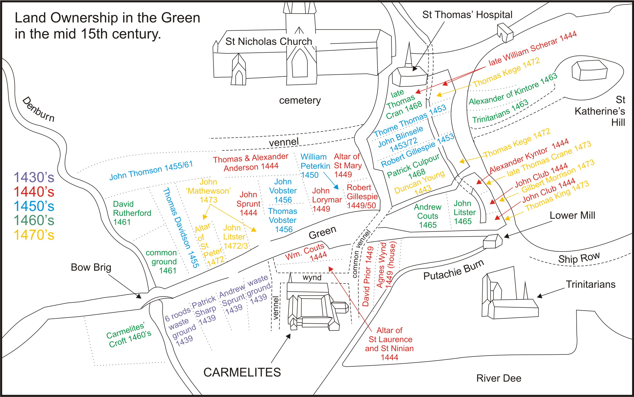
'Item for the Wheitt freris yardis persentlie occupied be James Nicolson Whairof he aillie a sett of sex yeares with provision it suld ailli ipso facto he not paying at the term appointed 4 bollis malt rin mett. Item from James Nicolson in the Whyit freres for his house and yard presentlie occupied be himself qlk hee hes in few of vs 8 markis. Item for the Smiddie lying at the Whyit freres presentlie occupied be William Smyth* 6 markis. He wald be removed at the nixt Vitsonday because he is an ewel debtour. Item from Jhon Mitchel for his house yard barn and kill lying at the Whyit freres qlk he holdis in few of vs the chartour is maid bot lying in my Lord Marischallis handis 25 markis… Item for the Whyit freres yard occupied somtyme be Patrik Malyson now be Thomas Malyson and his subtennent Jhon Mitchel Whairof the said Thomas has no sett bot was ewer owersein be me for M Thomas Malyson cause against the qlk Thomas we have a decreit of removing ano 1596 in our book of processe…' (Anderson 1889, 92-8).
Thus there seem to have been four property divisions on the lands where the friary had stood. Principally two houses: those of James Nicholson and John Mitchell, with yards; one 'smiddy' (Will Smith) and one not described (John Malyson and Mitchel as subtenant).
In Principal Gray's rental of 1606 considerably less evidence is given concerning the Whitefriars. It reveals that 'in Mr Roberts ailli the whyte friers yeard occupied be James Nicolsone is sett for foure bolls bear rind mett qrvpon I have made the s[ai]d James ane new sett for 27 merks yeirlie. Alwayes I reckone it ai as foure bolls bear, 4 bolls' (Anderson 1889, 105). In the College Rental of 1631 the following information is relayed: 'Item out of John mitchelles hous barne [y]ardes kill lyand in the Greyn at the Quhytfreris xiiij lib' (UA MS M56 fos 35r-36v). As both of these rentals gives only one tenant, it is tempting to assume that that all four properties had been amalgamated into one. However this is only conjecture: in 1606 the tenant is given as James Nicholson, possibly the same one as appeared in the 1598 rental. Whilst in 1631 the tenant is John Mitchell, again a name that occurred in the 1598 rental. Thus it is also possible that both of these rentals were imperfect. Although it should be noted that by 1631, Mitchell's rent is given at the very high value of £14 per annum, thus suggesting that the lands may indeed have been amalgamated.
In the next college rental, of 1640, it was recorded that £14 6s 8d was received from 'John Alexander Marjorie Jamiesone out of the gairden in the grein callit the Carmelite friers gairden…'. Jamieson was later, on 26 June 1663, granted a tack on the friars' lands for nineteen years. The tack itself is worth quoting on account of the details that it gives of the land: 'of auld called the whyt friers yeards As the samen is limitat and aillie with the north most barne at the entrie sumetyme callit the aillie Togither with the [y]eard callit the stank[y]eard west frae the said aillie Lying in the grene of the said bugh As the samen is presentlie occupied be James Raynie tennent and possessour therof…' Tack was given for 19 years at a rate of 42 merks yearly (UA MS M390/12/69). The 1640 rental contains the unusual entry of a feu duty of £14 3s 4d from 'William Mitchell out of his houssis and yeards in the grein lyand contigue to the old Carmelite church at the back of the trinitie gairden marching with the site mark…' (Anderson 1889, 238-40). This entry is odd it seems to indicate that the remains of the Carmelites' church was in some sense still visible.
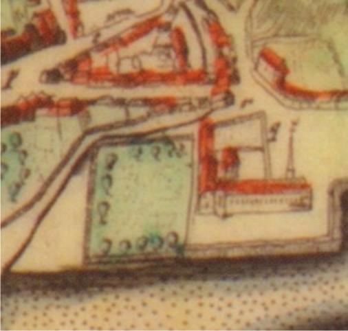
In 1661 Parson Gordon drew his map of Aberdeen and wrote his accompanying Description. The map clearly shows an empty area where once the Carmelites' buildings stood. This visual representation (Figure 11) is very interesting: the Carmelites' buildings had been spoiled and only open land had been left. The Trinitarians' place is still occupied as Gordon shows (Figure 9),but the Whitefriars' became essentially an open site. Presumably the 'garden' of the friars, as it was increasingly known, was given over to market gardeners. There is evidence for this as we will see below. Moreover, the excavations at 45-59 Green produced evidence of medieval occupation, but that the site was an open area between the late sixteenth and mid-eighteenth centuries (Murray 1982, 85-91).
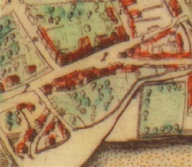
One of the other surviving elements of the friars' buildings was also located in the Green, but was at some distance to the site of the friary proper: this was the friars' kiln. This is clear from Parson Gordon who described it thus: 'which standeth in the outmost south corner of the citie, known this day by the name of the Freer Killne' (Innes 1842, 16). It stood at the bottom of what was known as the vennel that led to Poynernook Croft and now known as Rennie's Wynd (Figure 10; Figure 12). On Parson Gordon's map (Figure 8) the vennel can be seen running south just to east of the number 8. This history of ownership of this site (which fell to Marischal along with all other Carmelite possessions) is traceable from 1640. In the 1640 rental there occurs an entry for £6 13s 4d from 'a few out of the malt barnes at the friers kill occupied be the successors of Robert Leslie in the grein payit be Francis Irvine and now W[ ail]m Gellie…'.
The 1716 college rental reveals that £14 6s 8d was received as rent from 'the Relict of Mr John Alex[ande]r aillie Jameson out of the Garden in the Green called the Carmelite ffriars Garden…' The rental also records £13 6s 8d from 'the Carmelite ffriers Garden from the relict of Peter Hill and now be Alexander Taylor. And finally, another £13 6s 8d from 'the Carmelite ffriers garden [torn] by Alexander Thomson and Thomas Reid…' (UA MS M387/3/1/2). Whilst £6 13s 4d was from 'the malt barns at the friers kill occ[upie]d by the Successors of Robert Leslie in the Green payed by ffrancis Irvin and now W[ ail]m Gellie.' Later, in a sasine of 5 July 1731, to John Farquarhar, his land is described as being bounded on the east by the 'land sometime of the Carmelite ffriars and now of the heirs of William Mitchell…' (ACA Sasines Register 57, fo 318r). The 1716 rental would seem to suggest that the lands upon which the friary once stood were once again divided into three distinct properties. Perhaps they had been divided again after 1640, or alternatively they never had been amalgamated and that it was simply an illusory interpretation suggested by the extant evidence. At any rate the site of the friary remains in three distinct parts until the late eighteenth century.
Until 1716 the college rentals are all separate manuscripts, whilst between 1755 and 1859 they are all collected together in two continuous volumes. The following information can be derived from the start of the first volume:
| 1755 | Carmelite Friars Garden | Alexander Anderson, gardener | £4/15s/6 2/3d |
| 1755 | Carmelite Friars Garden | Heirs of John Maitland | £2/4s/5 1/3d |
| 1755 | Carmelite Friars Garden | Peter Reid, mason | £2/4s/5 1/3d |
| 1755 | Malt Barn at Friars kiln | James Mackie Maltster | 11s/1 1/3d |
| (UA MS M56, fo 52r) | |||
The college accounts show that the land remained with these people for the next 13 years. In 1756 the heir of John Maitland was revealed to be Adam Maitland, described as a farmer in Thomistoun (UA MS M56, fo 59r). In the late 1750s or very early 1760s Reid built upon his part of the land. A sasine records: 'lately built by the said Peter Reid upon the ground commonly called the Carmelite Friars Churchyard…' (ACA Sasines Register 63, fo 191v). In 1768 Adam Maitland died and that part of the Carmelite Friars' Garden was taken over by his heirs (UA MS M64, fo 13v). The Procuratory accounts for the year 1770 show that the heirs of Maitland were represented by Andrew Pirie (UA MS M64, fo 23v). Note that during this period the value of the feu remained constant.
The separate entries are merged into one in the 1774 accounts, and the value given is the one received from all of the feuars (UA MS M64, fo 37v). The year 1781 brings the next change of ownership: in that year Anderson died and his widow took over his portion of the Friars' Garden, whilst the third portion (previously feued to Reid) was feued to William Milne at Udny (UA MS M64 fo 53v). From here the value of the feu as collected from the feuars begins to fluctuate, suggesting perhaps that there were changes in land use going on or other economic problems. From 1783 the only two feuars for the garden are shown as Widow Anderson 'and others' and Robert Martin (UA MS M64 fo 57v). In 1787 Robert Martin died and his widow took the feu (UA MS M64 fo 64v). The accounts of 1790 reveal an interesting piece of information; they state that there was cash received from 'the heirs of Adam Maitland and Peter Reid for Meliorations of Houses on Carmelite friars Garden…' (UA MS M64 fo 70v). This suggests that when Reid built on his portion of the lands in the 1760s that he built a number of houses. This would indicate a change in land use and thus would relate to the fluctuations in the value of the feu, as noted above.
The lands of Mackie, the maltster, which were those described as the Friars' Kiln, can be traced through the eighteenth century with some ease. William Gellie, who had been a aillie, had the land in the early part of the eighteenth century. The lands were described as being on the south of the Green, with the high street to the east and north, and also to the north a tenement, belonging to Aedie, and to the west the yard of Gellie but to the south the yards of the Carmelite friars now belonging to Gellie (ACA Sasines Register 58, fo 111v). As the lands were bounded on the east by the high street, this would seem to be what becomes Rennie's Wynd. During this period at least one commentator thought that Gellie's barn was the location of the friary. Alexander Keith's 1732 View of the Diocese of Aberdeen contains the line 'their convent, or church…stood at the end of the Green, (where now the barn of one Gelly a maltster is)…' (Robertson 1842, 203). This would seem to be wrong: a confusion arising out of the name of the friars' kiln and its proximity to the old site of the friary proper.
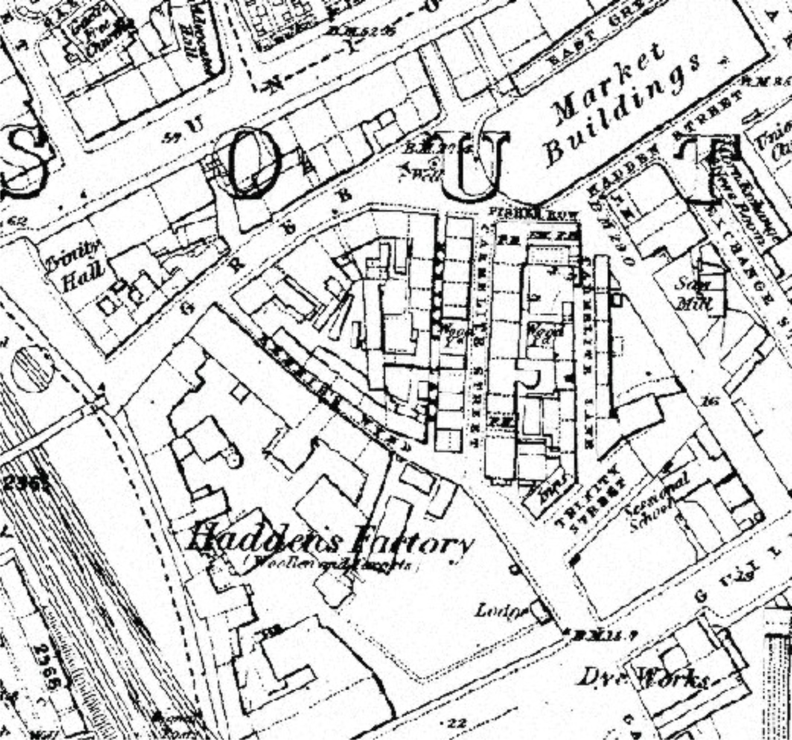
After Will Gellie, the lands passed to Robert Gellie on 20 February 1735 (ACA Sasines Register 58, fo 199v). After Gellie the lands passed to William Simpson on 21 October 1748 (ACA Sasines Register 60, fo 100r-v). After Simpson, they passed to James Mackie on 29 December 1756. In the relevant sasine there is the following description of the land known as the Friars' kiln: 'the croft or yeard sometime of the Carmelite Friars and now of the Marischal College, Betwixt the said croft or yeard on the East and South, and the Common way leading from the Pynnernook to the said Green at the West and North…All and Haill that little Barn and kiln…' (ACA Sasines Register 62, fo 32r). This means that the road known as the one leading from Pynnernook to the Green is the one which becomes Rennie's Wynd. George and William Rainie got a sasine in their favour of the lands of James Strachan in the south side of the Green on 27 January 1759. These lands are described as being bounded by the yard once of William Gellie (ACA Sasines Register 62, fo 210r). Perhaps it was from these people that the name Rennie's Wynd, which is originally given as Rainie's Wynd, took its modern name. The sasine here referred to also points out that the lands that had once belonged to Gellie now belonged to Hadden and Farquhar, which may have been the early stages of Hadden's factory (Figure 10) which was later built on what was the Friars' kiln. Nevertheless, the lands became known in the later 1770s as Baillie Gellie's barn rather than the Carmelite friars' (kiln) land (ACA Sasines Register 68 fo 45v-46r and 71, fo 31v).
The 1790s brought a change in the land of the friars: from here the modern street layout began. The Procuratory accounts for Marischal for 1792 are very revealing of this change. At this point it would seem that the College felt that it was not getting enough money from the feus of its lands and now wanted to feu the land out with the intention of stances being created for houses along new streets. Unfortunately no relevant paper work for the Friars' Garden has been traced. However the policy can be seen in operation on the Poynernook Croft, which was also at one time land belonging to the Carmelite friars. That croft was feued to Richard Ransom in 1783. The feu charter is explicit. It states that the land was 'capable of great improvement and that it is now in our power by feuing out the same for stances of houses with proper gardens to draw a much higher yearly rent therefore than what has hitherto been paid or could be obtained by setting of the ground as formerly for the purposes of Gardening and agriculture…' (UA MS M387/3/2/6). The previous reference is in fact to a folder of material, containing 19 pieces in total, which is described in the University of Aberdeen's catalogue as containing papers relative to the Carmelite Friars' Garden. This is however erroneous as they relate to Poynernook Croft. The reason these papers have been preserved is because once Ransom had sub-feud the lands, collected the sub-feu monies and had then absconded. Many legal wrangles followed, which were aggravated by the fact that when Ransom's land had been lined out a mistake had occurred and he got an extra piece of land which had legally been feued to the then Provost. Despite the Provost having paid for the land, it had been incorporated into that of Ransom and when the regents of Marischal took legal advice in Edinburgh they found, to their horror, that if Provost Young built upon the ground and Ransom returned, Ransom would be legally entitled to evict Young and that Marischal would be liable for any damages. The ultimate outcome of this debacle was not revealed within the folder.
Despite the fact that Poynernook was a croft it may be fair to say that a similar policy had been in operation with regard to the Carmelite friars' garden. However, from the earlier Procuratory accounts we can see that some buildings had been erected on the friars' land, for example those of Reid, built in 1760. At any rate, a decision to change the use of the friars' land seems to have been taken at some point in 1792. In the accounts for that year the following entries occur:
| 'Arrears Anderson & J Duthie for Carmelite garden | 3/18/4 |
| Interest on debt for Carmelite garden | 2/11/9 |
| Expense removing A Anderson Carmelite Garden | -/17/4 |
| Advertising leases | 1/1/- |
| Mr Downey addition to Chartulary | -/5/- |
| Bill Adams | 1/18/2 |
| John Arthur for Carmelite garden | 1/11/- |
| By sundry articles to Carmelite Garden placed | 3/13/3 ½' |
| (UA MS M64, fo 75r) | |
The adverts for feuing the land came out in two different editions of The Aberdeen Journal in 1793. On 7 January the following appeared: 'The following to be added to at Candlemass next the GARDEN at WHITEFRIARS, adjoining to the Green, and within the burgh of Aberdeen, at present possest by Alexander Anderson, with the dwelling houses thereon.' (ACL, Aberdeen Journal, 7 Jan. 1793). Later, in June of that year the following appeared:
'Feus for Building in the Green. A New street is to be opened, and STANCES of HOUSES immediately feued off, on that ground called the CARMELITE FRIARS GARDEN, south side of the Green, opposite the well. The ground lies in an open airy situation, perfectly dry, with a gentle declivity to the south, having a well frequented market place hardby and is on the whole as eligible and central a situation for building on as any in town. Intending feuers may apply to Alexander Rhind or George Hogg merchants, Green, who will point out the bounds and treat as to particulars.' (ACL, Aberdeen Journal, 10 Jan 1793).
From this it would seem that Rhind and Hogg had feued the land from Marischal and they were the people who were going to sub feu the land.
Interestingly after the second advert in The Aberdeen Journal, a letter was written to the editor concerning that piece of ground. It reads:
'It has often been considered by strangers, as a sever reflection upon the taste of the citizens of Aberdeen, that the entry from the south to this large and increasingly populous city, should be so indirect, crooked, and incommodious, and no means used to better the entry. Ever since the old houses on that part of the White Friar Garden opposite the Green well have been pulled down, I have thought that this area, if planned with judgement, might easily be made a tolerably broad and commodious entry by an embankment round the Trinity Church, in a line to the Shore Brae…It would tend, in a very great degree, to raise the value of the property on both sides of such entry from the Green thro' the White Friar Garden, as well as to other parts of it eastward to Mr Smith's houses-to the property on both sides of the road, betwixt the White Friar Garden and Trinity Garden…' (ACL, Aberdeen Journal, 17 June 1793).
Unfortunately it has not been possible to find any of the original papers relating to this feu or indeed any of the original feu charters. However one of the charters has been printed by Anderson in the Records of Marischal College…. Anderson quotes the charter, dated 20 January 1794, as describing the land as being bounded
'on the East by the heirs of Alexander Smith late merchant in Aberdeen; on the North by the Green and Fishery; on the West by Brand's Wynd and Rannie's Lane to the north-west extremity of of James Mackie's feu, then by the north and east of the said feu along the march till it join the lane called Wapping Street; and on the South by the public road from the extremity of the foresaid lane leading towards the Trinity till the same join the boundary of the land belonging to the heirs of the said Alexander Smith.' (Anderson 1889, 238).
There are a number of issues with this quotation. Firstly, no reference is given for this charter: indeed it occurs within a footnote, suggesting that Anderson had seen the original charter, which was presumably in private hands. Secondly, it is not known to whom the charter was given. Thirdly, does the above description relate to the entire parcel of land known as the Friars' garden or to a smaller sub-feu? I would suggest that it relates to the entire feu. Lastly, the charter notes that the land was bounded on the north by the Green. In the time of the friars this was not the case, so had the Green changed or had other land become absorbed into that parcel of land known as the Friars' Garden? The latter case may be likely: it could even be that the land which became absorbed into the Friars' Garden was adjacent land owned by the Carmelites but not part of the lands upon which the friary once sat. At any rate, the charter seems to relate to the creation of Carmelite St, which thus ran through what had been the Carmelite friars' garden (Figure 7).
Following this, the money derived from the Carmelites' lands becomes variable. The total comprises the money rent and the monetary value of a certain number of bolls of bear. As the value of a boll varied from year to year, the total value fluctuated in correspondence. To render the total for each year of the accounts is not practical. However, I have expressed, in the following list, the monetary value and the bolls.
| 1793-99 Money rent out of Carmelite Friars' Garden | £16/13/4 | 13 ½ Bolls of Bear |
| 1800-06 Money rent out of Carmelite Friars' Garden | £23/6/8 | 18 ½ Bolls of Bear |
| 1807-25 Money rent out of Carmelite Friar's Garden | £30 | 23 Bolls 2 firlots |
| (UA MS M64, various fos) | ||
| 1826-59 Money rent out of Carmelite Friars' Garden | £30/10/4 | 18 Q[uarter] |
| (UA MS M65, fo62v for the first calculation including tax) | ||
The other points worth making from these college rentals and accounts are that from 1810 the money rent is recorded as coming from 'Alexander Rhind and others…' (UA MS M64 fo.96v). Finally from 1842, the total money derived from the Friars' Garden is calculated by the addition outlined above minus tax (generally at £2, although varying according to the fluctuations in rent) (UA MS M65, fo 62v). The total money derived after 1842, although there were fluctuations, was generally in the region £45-55. Despite this general upward trend in rents in the area, it is possible that the reputation of Carmelite Street was adversely affected in this period. Writing in 1897 George Walker wrote: 'The modern and fashionable Marischal Street, and the still more fashionable Carmelite Street-in which some of the best country families have their residences…After 1830 the country families and gentry forsook Carmelite Street, in consequence of the dung stance of the city being placed at Poynernook' (Walker 1897, 48-49).
It is not clear when exactly Carmelite Lane was created as opposed to Carmelite Street (Figure 10). From the Police Commissioners' records it would seem that the Lane defined the eastern extremity of the Garden. The Police Commissioners' records for the nineteenth century add that the Carmelite grounds (Lane and Street) were under the proprietorship of Rhind, Hogg and Clerihew (ACA, Police Comm I, 253). Yet despite the ground having been feud out for the creation of Carmelite Street in 1794 it was not for another year that Carmelite Street itself was actually lined out. It fell to the Police Commissioners in November 1795 to undertake this (ACA Police Comm I, 34). The breadth of Carmelite Street as first envisaged was not to be under 30 feet but it soon became obvious that 40 feet was required (ACA Police Comm I, 35 and 37). Carmelite Street however remained a mess for the first five years of its life. On 20 October 1800 the proprietors of Carmelite Street wrote to the Police Commissioners requesting that a kerb stone should be laid. However as the Commissioner's funds were low, nothing was done straightaway (ACA Police Comm I, 219).
Two years later the condition of Carmelite Street had not improved: on 11 January 1801 the Commissioners ordered that the street should be made level and all the soil at the lower end of Carmelite Street should be removed (ACA Police Comm I, 246). This is an interesting entry: given that the friars' land had for such a long time been a garden and that much in the way of garden soil had been found at the archaeological excavations, it is worth wondering if this soil was the top soil of the friars' garden which had been shifted to the lower end of Carmelite Street, as the proprietors laid out their stances and houses. Later, on 25 October 1801, the Police Commissioner received a letter from the proprietors requesting that a pavement be laid. By this point the situation of the street was such that the Commissioners felt obliged to act. They spoke of the 'absolute necessity of pavement…' and ordered that estimates should be solicited. The proprietors however wanted London carriageway stones and had started a subscription amongst themselves to meet in part the costs that would thereby be incurred. They presented £28 to the Commissioners, although the difference in value between pebbles and carriageway stones was in fact, £45. Partly due to the difference and partly because not every proprietor had subscribed, the commissioners turned down this request, but agreed that estimates for both works would be solicited (ACA Police Comm I, 263-4). The estimates were received on 18 November 1802 and the contract went to William Wedderburn to trim and lay, in the end, London carriageway stones from 8-9 inches deep at 3s 3d per square yard and kerb stone at 9d per foot. In the end the subscription was used (ACA Police Comm I, 265-6). In the 1820s the Police Commissioner's Records reveal that the area in general was improved in a slow, ad hoc, and piece meal fashion: where new drains became desperately needed, they were fitted and new gas lights were introduced as and when they were required (For example see, ACA Police Comm III, 287). Indeed this is the process that is to be found all over the burgh at that time as the modern street plan and appearance of Aberdeen began to develop. It was at this time that the more modern Green was created.
Throughout this period of development, from the late 18th century to the present day ground disturbance in the area has often revealed evidence of the previous Carmelite occupation of the Green. In many cases where work has been undertaken in this area human remains have been found. The following was reported in the newspapers on Saturday 20 June 1891:
'One of the best signs of a broadened interest in the past has been shown these last 10 days in the operations of digging carried on in Carmelite Lane on the ground adjoining Mr Anderson's icing fish establishment. This little square of ground, now under the pick and shovel of a band of workmen, was part of the burial place of the old monks, and crowds of men and boys may have been seen there, in quiet observation, watching the workmen. Previous observations had disturbed many from their first resting place, for, at more than one part of the ground, deep square holes have been made, into which, in rude confusion, barrowfuls of bones had been gathered. But many a grave has yesterday and today been broken into in the old cloister garth of the fathers, for the first and let us hope next to that last and final movement. In all the well marked graves the writer examined there was no trace of coffin, no nail, no fragment of wood, nothing but the much decayed bones and white shining teeth. At one corner the skulls of those who had found sepulture there had on then, even now, traces of rough handling in life. At the shoulder of one of them lay two brass rings, parts apparently of some brooch like fastening, which had left on the bones of its wearer in his last shroud a metallic verdigis impression. How strange it is to stand in the hurrying crowd of a great city, as many have stood lately in Carmelite Lane, and note how little the word 'Sacred' protects the poor inhabitant below' (ACL Aberdeen Journal, 20 June 1891).
Whilst on 12 November 1908 the following was reported:
'In Carmelite Street workmen are at present engaged in carrying out alterations on an old property belonging to Mr Henry Ross, Exchange Bar, with the view of remodelling it for the purposes of a modern restaurant and boarding house. The ground floor has been completely gutted out, and in the course of the excavations a discovery was made in the shape of five or six human skeletons. The skeletons were for the most part complete, the preservations of the teeth being very marked. During many years in which old properties in the locality have been razed to the ground for the purpose of substituting new buildings, it has been a common experience to unearth skulls and bones of human beings, and for the most part these have been re-buried.'
This report goes onto to note that a similar pattern of development unearthing human remains had been observed at the sites of the Trinitarians, the Franciscans and the Dominicans. In the case of the Dominicans at Schoolhill the report went on to state that the human remains found there, when the Art Gallery was being built, were reburied in the grounds of Robert Gordon's College (ACL Aberdeen Free Press, 12 November 1908). There had been earlier newspaper reports of remains of the Dominican friary having been discovered in Schoolhill (ACL Aberdeen Journal, 24 April 1833). G.M.Fraser, the first librarian of Aberdeen Central Library recorded, in his notebooks, a further discovery of human remains in the Green, which did not find its way into the newspapers. He noted:
'In June 1924, when the workmen were opening the ground under the pavement at No 10 Carmelite Street, they came upon a bone, which Mr Elrick (who was setting in the electric light) took it up to Dr Low, Mar[ischal] College. He pronounced it a bone of a man…' (ACL, G.M.Fraser's Notebooks No. 53, 28).
The remaining history of the place of the Carmelite friars is expressed in Table 10, which is formed by extracts from the relevant volumes of the Valuation Rolls held by Aberdeen City Archives. These give the address, proprietor, tenant, use of the land and the value of the rent. The entire entries for all of Carmelite Street, Carmelite Lane and Rennie's Wynd for 1855-1985 are given in the table. There are a number of general comments about the nature of property use and ownership that can be discussed here. What immediately becomes apparent is that between 1855 and 2003 Rennie's Wynd was generally always been given over to accommodation, whilst the other places were mostly shops, or a mixture. Whilst the pattern for Carmelite Street shows that after the 1890s more property was used for commercial purposes. It is also clear that nearly 33% of the entries for Carmelite St list women as the owners or renters of the property. In terms of Carmelite Lane properties were mostly given over to commercial purposes. The level of women's interest here is at 21%. Overall for all three streets as the twentieth century progressed less and less entries were records of residential property in the area. Indeed by the 1970s and 1980s residential property was almost entirely non existent. Use of the area for residential property is now the norm in Rennie's Wynd and parts of Carmelite Street, although Carmelite Lane has not changed so significantly.
Internet Archaeology is an open access journal based in the Department of Archaeology, University of York. Except where otherwise noted, content from this work may be used under the terms of the Creative Commons Attribution 3.0 (CC BY) Unported licence, which permits unrestricted use, distribution, and reproduction in any medium, provided that attribution to the author(s), the title of the work, the Internet Archaeology journal and the relevant URL/DOI are given.
Terms and Conditions | Legal Statements | Privacy Policy | Cookies Policy | Citing Internet Archaeology
Internet Archaeology content is preserved for the long term with the Archaeology Data Service (ROR). Help sustain and support open access publication by donating to our Open Access Archaeology Fund.