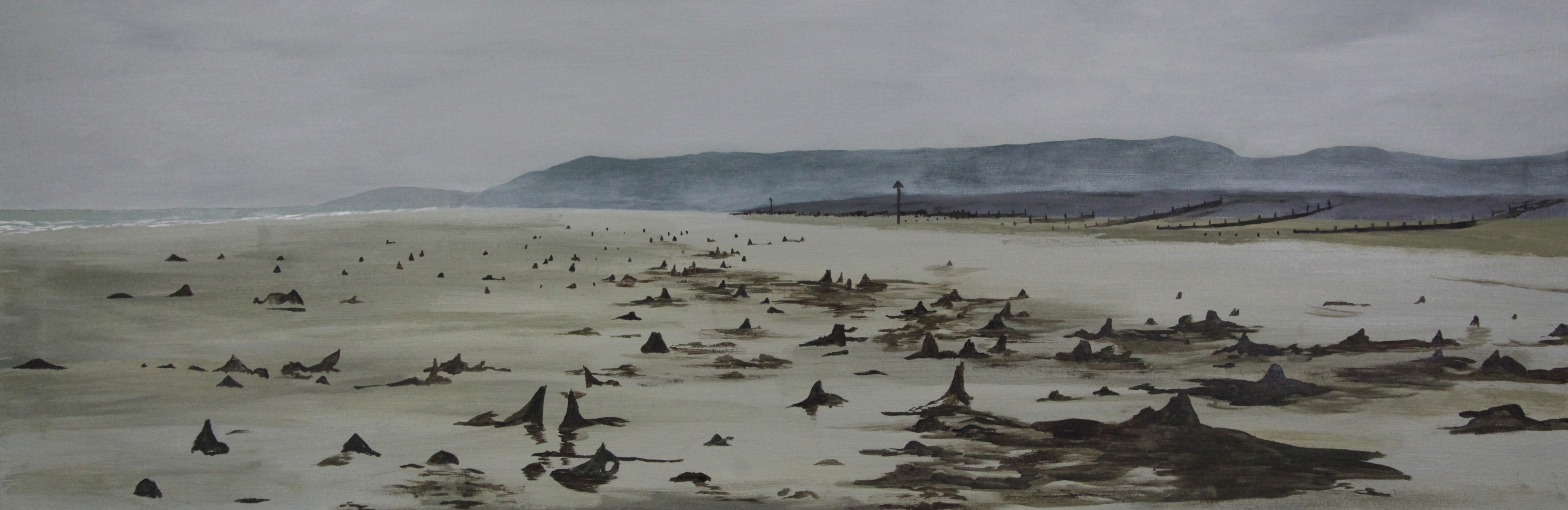
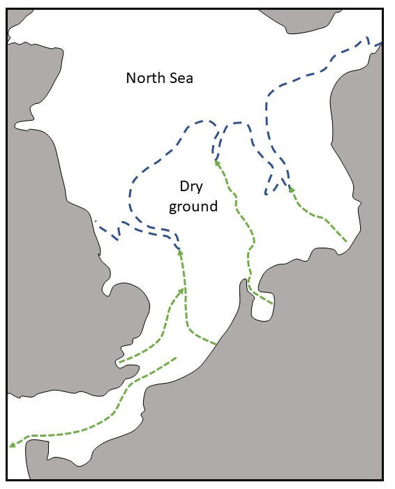
One of the earliest attempts to envisage the geography of the Pleistocene period in Britain was attempted by William Boyd Dawkins (Dawkins 1874; White 2017). His work is likely to have inspired the geologist Clement Reid who published Submerged Forests in 1913, in which he reviewed a series of sites around the British coastline where the former presence of woodland, in an area now occupied by the sea, was evidenced by well-preserved tree stumps emerging through beach sands (Figure 3). From these observations he argued that this was evidence for lowered sea levels in the past and he deduced this implied that there were formerly extensive dry land areas offshore of our coastline that had been flooded as sea levels rose. This deduction, coupled with a basic understanding of the seabed topography in the North Sea and the emerging science associated with understanding the ice ages, allowed him to envisage a large area of dry land once existing in the area (Figure 4) that was flooded in response to melting glacial ice causing global sea level rises. His map subsequently inspired Grahame Clark when he was pondering the feasibility of contact between the early Mesolithic peoples of NW Europe and Eastern England (Clark 1936). Confirmation of a human presence in this landscape was made in 1931 after the fishing boat Colinda discovered a harpoon point embedded within a large block of organic sediment pulled up from the North Sea (Burkitt 1932).
Despite these early forays into the geology and archaeology of the sea floor, for much of the 20th century consideration of these submerged landscapes was minimal because maps of the seabed were imprecise and lacked the detail of equivalent terrestrial maps. Thus, despite the fact that geological specialists (see Murray-Wallace and Woodroffe 2014 for a summary) had been working hard to document and quantify sea level change following the last glacial maximum when global sea levels were approximately 125 to 150m lower than at present owing to the extensive nature of the large ice sheets (Yokoyama et al. 2000; Lambeck and Chappell 2001; Peltier and Fairbanks 2006) (Figure 5), little was known of the lands they flooded. Global warming, causing ice sheet shrinkage following the Last Glacial Maximum, resulted in the return to the oceans of water previously trapped in the ice and consequently sea levels began to rise. For much of the shallow continental shelf surrounding southern Britain (beyond the area of extensive glaciation), sea levels rose rapidly across a stable landscape. However, in Scotland, where glaciation had resulted in crustal subsidence, owing to the weight of ice on the landscape, rapid uplift of the crust preceded sea level rise so that much of the shelf area remained dry with little or no flooding (Bradley et al. 2011). As a result, beaches that formed 12 to 14 thousand years ago are now some 30 to 40m above sea level. By the late 20th century, however, the stage was set for the issue of submerged landscapes to re-emerge, thanks to the new frameworks for sea level history coupled with a range of new techniques for investigating the seabed.

The reclaiming of these landscapes began in 1998 with a series of articles published by Bryony Coles (1998; 1999; 2000) that gave serious consideration to the area of the North Sea she called Doggerland (southern and central North Sea areas). This was followed by extensive study of 2D and 3D seismic data, some of it released by the oil and gas industry (Gaffney et al. 2007; 2009), that demonstrated beyond all doubt that such areas had formerly been occupied by rivers, lakes, marshes and low hills. Considerable academic interest has recently been shown in these submerged landscapes, as evidenced in the works of Bailey et al. (2017) and Flemming et al. (2017). At the same time, commercial exploitation of the seabed for mineral exploitation or by the renewable energy sector (Bicket et al. 2014) has resulted in archaeological survey and evaluation of the shallow continental shelf seas. Such work now routinely requires cores to be taken of deposits beneath the seabed to recover samples (Figure 6) for dating and paleo-environmental analysis, allowing the key environmental changes (including the onset of flooding) to be determined accurately in some locations.

The process of flooding, from a geological perspective, is known as a marine transgression, i.e. when a body of water rises relative to a land surface and the coastline moves onshore to a position of greater elevation (relative to its starting point). The evidence from our shallow seas categorically documents such an event has taken place following ice sheet shrinking around 20,000 years ago (Brooks et al. 2008). However, what remains to be ascertained are both the precise timing of the event (for particular parts of this landscape) and the nature of that transgression (i.e. was it rapid and catastrophic or gentle and gradual). The latter is in fact a reflection of the argument that has been on-going in the earth sciences since it was initiated in early 19th-century debates between Cuvier (1827) and Lyell (1830) and since revisited by Ager (1993). What we are able to do for the British coastal zone, however, is identify three zones in which different scenarios for flooding might be considered (see Figure 1):
These are considered in detail below, however, it should be noted that these regional patterns are a justified simplification and additional factors that may have influenced flooding in some or all of these regions require our consideration:
Since approximately 6000 years ago, sea level fluctuations have been minor and have only locally impacted coastal paleo-geographies (albeit perhaps catastrophically for local residents, which is a point perhaps of considerable significance in terms of local stories).
Turning to the archaeological evidence, the recovery of Mesolithic material from the seabed is common in the eastern parts of the North Sea (Fischer 1995; Gron and Skaarup 2004; Nymoen and Skar 2011; Jöns and Harff 2014) while that for the Palaeolithic is presently somewhat limited (Tizzard et al. 2011; 2015; Pope and Bates 2016). Within the English Channel, archaeological material is significantly rarer; however, two outstanding sites exist. In the Solent, at Bouldnor Cliff, Mesolithic archaeology has been recovered at the base of a small submerged cliffline north of the Isle of Wight (Momber 2004; 2011; Momber et al. 2011). Across the Channel significantly older Palaeolithic material has been recovered at the foot of a submerged cliffline off the Cotentin Peninsula (Cliquet et al. 2011). Notwithstanding these examples, despite a significant investment in survey and evaluation of potential sites in British waters, few sites likely to contain archaeological remains have been discovered. Although our knowledge base for these submerged landscapes has increased significantly in the last decade we are still left having trouble placing humans into this landscape.
Despite the absence of evidence for human activity within these drowned landscapes this lack of sites is not taken as evidence of absence and certainly has not inhibited debate about the impact of flooding on local populations using this landscape prior to and during inundation. So, for example, Coles (1998) has suggested that loss of landscape would have been compensated for in some circumstances by creation of new habitats while Gaffney et al. (2007) sees the same set of changes as likely to be devastating. Leary (2009; 2013; 2015) has considered the impact of gradual and catastrophic flooding on peoples in this landscape and concludes that:
'climate change can affect people and communities on many different spatial and temporal scales, which produce a wide variety of responses, and that environmental change can benefit individuals as much as disadvantage them' (Leary 2009, 235).
Therefore, while the impact of flooding on past populations living in these now submerged landscapes remains to be demonstrated it is likely that a variety of responses, physically and psychologically, would characterise these responses to stress and change.
Cite this as: Kavanagh, K.E. and Bates, M.R. 2019 Semantics of the Sea — Stories and Science along the Celtic Seaboard, Internet Archaeology 53. https://doi.org/10.11141/ia.53.8
Internet Archaeology is an open access journal based in the Department of Archaeology, University of York. Except where otherwise noted, content from this work may be used under the terms of the Creative Commons Attribution 3.0 (CC BY) Unported licence, which permits unrestricted use, distribution, and reproduction in any medium, provided that attribution to the author(s), the title of the work, the Internet Archaeology journal and the relevant URL/DOI are given.
Terms and Conditions | Legal Statements | Privacy Policy | Cookies Policy | Citing Internet Archaeology
Internet Archaeology content is preserved for the long term with the Archaeology Data Service (ROR). Help sustain and support open access publication by donating to our Open Access Archaeology Fund.