'Let me now speak of them, asking pardon for introducing marvellous stories … since I am unwilling to pass them over in silence and in a way to cripple my investigation.' (Strabo, cf. Patterson 2013)
This area is the largest of our three and appears to contain the smallest body of flood-connected narratives. Geologically the area has been dominated by uplift through much of the last 15,000 years (Lambeck and Purcell 2005; Bradley et al. 2011) in response to ice loss and crustal rebound. Consequently, rising sea levels have lagged behind crustal uplift and therefore the area has experienced little or no flooding at a regional scale. This resulted in the coast line remaining close to the present one for much of the Late Pleistocene/early Holocene time when global sea levels were rising until about 6000 years ago, when modern datum were established.
Stories of the sea are common here and it could be argued that, from a symbolic perspective, motifs such as glashtyn, mermaids, sea horses, selkies et al (see Thompson 1966, for all motif indices) represent flooding in its various forms and the sea tales within this region are dominated by stories of such supernatural creatures. They share their narrative space with spectral ships, sacrifice, smugglers, sailors, storms and the ubiquitous shipwrecks (the best known of the latter is, of course, the legend of Alexander Selkirk, which is credited as being the inspiration for Daniel Defoe's Robinson Crusoe). Predominantly though the Scottish ballads, oral tales and superstitions are weighted towards the saints and the supernatural, with spiritual mythologies out of which only one prevailing inundation narrative floats free — that of the Cailleach. The Cailleach, meaning 'old woman, hag, crone, nun, or veiled one' (Sorita and Rankine 2008, 2) appears regularly as the source of water features in the landscape, possibly including that of Lochar Moss under the local name Gyre Carlin. According to R.H. Cromek (1810) there existed 'from the time of Prince James' a rhyme stating that the hag Carlin traversed the shore at low tide between the Solway Firth and Locharbriggs by enchanted horseback as part of her coven's Hallowmas Rade (the connection between horses and water is one that we find consistently in all three of our geographies with motif indices B71; B401; F234; E402.2 and G303.7). One day the tide returned unexpectedly, disrupting her gallop; out of pique she struck the waves with her magic stave and rendered the sea banished to leave marshland in its wake forever more.
The non-supernatural elements of this story hold some water for, as the naturalist Robert Chambers (1826) comments, artefacts such as boats, iron grapples and anchors were discovered in his time in that very stretch of peat bog during its draining and the process by which they came to be there had been immortalised in the local saying:
First a wudd, and syne a sea;
Now a moss, and aye will be;
Geologically such a saying might in fact represent a cycle of flooding (or marine transgression) across a woodland followed by a period of marine regression when the sea was replaced by saltmarsh (moss). Scotland provides evidence that just such features are in fact common, as marked by the presence of raised beaches around the coast line. However, even if such links can be made, this cycle may be no more than a local event caused, perhaps, by a shift in the position of the beach or operation of the tides. The Cailleach's involvement in this inundation through pre-19th century tradition is questionable, as it has since come to light that Cromek's account was most probably the fictitious work of a poet by the name of Alan Cunningham (Dennis 1987). What is interesting from our perspective is that while the Carlin rhyme is most likely purely fictitious the rhyme itself still exists, the tale is living, as is the couplet concerned with the transition of woodland to moss and thus it still qualifies as a flood tale along the Celtic fringe.
Following ice sheet melting, marine waters gradually flooded the landscape of the North Sea and English Channel. Whether this was gradual or rapid (perhaps elements of both depending on geographical location) is presently unknown. Around 6000 years ago sea levels attained near current elevations (Figure 5) and, except where there has been recent extensive erosion, the approximate modern coastline was established. There followed a short period in which the sea retreated (marine regression) and forests grew where once saltmarsh existed between approximately 6000 and 4500 years ago (Long et al. 2000). The sea subsequently returned and flooded these forests, returning those locations to saltmarsh. Evidence for this phase of marine regression is typically preserved in the estuaries of our major rivers (Devoy 1977; 1979; 1982; Long et al. 2000). Whether extensive forest growth occurred along the open coastlines between the estuaries is difficult to ascertain because significant erosion impacted these areas since the forests were transgressed, removing any evidence for their former presence. The proximity to Doggerland is also significant here. The loss of the North Sea lands to the sea might logically be expected to impact on local populations either living adjacent to these lands or forced from them as a consequence of sea level rise.
Stories from this area lose the glashtyn and selkies but retain mermaids and smugglers, castles, monsters and lost bells while adding in skyships and invasions. A number of well-documented tales of this coastline include those of 1) Goodwin Sands. 2) The Bishop of Coutances, 3) The Well of Brading Haven, 4) Lyonesse and 5) Ker Is.
Goodwin Sands is otherwise known as The Ship Swallower owing to its reputation for claiming vessels, with no respect for their status if they fail to traverse its current-changing sandscape beneath the waters. These sands are sometimes said to be all that remains of the Isle of Lomea, the British Atlantis, which the Romans called Infera Insular (Gattie 1904). The geological history of the sands is obscure. Cracknell (2005) summarised the competing lines of evidence, showing either that the sands were a remnant of former dry land or that they accumulated as a sandbank complex following flooding of the Straits of Dover by marine waters. The inundation is said by the antiquarian William Lambarde (1536-1601) in A Perambulation of Kent to have occurred in the first part of the 11th century. At this time the Earl of Godwin (who was, curiously, supposed to have been elevated to his earldom through his earlier connections with King Canute, himself of diluvial fame) fell out of favour with Edward the Confessor, to whom he was an advisor. The Earl is recounted to have choked at Winchester (or Windsor) on a morsel of poisoned bread (or just bread) and at once his lands escaped capture by any other noble by sinking beneath the sea. Some versions (e.g. Anglo Saxon Chronicle) suggest that this occurred in the great storm of 1099. Or maybe it was 1086. Or 1085. Or even 1014; oral accounts vary but Lambarde asserts that:
'Hector Boethis, the Scottish Historiographer, most plainly writeth, affirming, that (amongst other) this place, being sometime maine land, and of the possession of the Earl Godwine, was then first violently overwhelmed with a light sand, wherewith it not onely remainith covered ever since, but is become withal a most dreafull gulfe, and ship swalower, sometime passable by foote, and sometime laide under water … so it may bee said either sea, or land, or neither of both' (Lambarde 1576, 97).
Let us sail out from the British coast for a moment to the skirts of Jersey, where we can consider The Bishop of Coutances and his Plank. While this story is a familiar one to Jersey islanders it is not so to other shores. In 1682 the historian Jean Poingdestre writes of a 'fabulous tale of the conjunction of Jersey to Normandy' (Poingdestre 1889) wherein the Bishop would cross back and forth by means of a plank, or bridge. He maintains that the locals affirm the crossings to have occurred in the 6th century, which he queries. His queries are met with assertions explaining that until the 8th century the boundary was still shallow but a storm was caused by a priest in La Rocque profaning on hallowed soil, causing divine retribution in the form of a storm that swallowed the marshy plain beneath an engulfing sea. Variant forms of the alleged legend exist, setting it sometimes during a cataclysmic inundation in 700 AD and sometimes two hundred years earlier in the time of St Lo and some four hundred years later among the monks of Mont St Michel. The local historian Tony Bellows (nd) has taken a different slant to the interpretation, proposing the flood to be no more than a symbol of independence and the traversed plank to be a political allegory for Norman religious authority over Jersey. Geologically we can be confident that the creation of a seaway between Jersey and France was created between 6500 and 7000 BP (Sturt et al. 2013) and despite the presence of significant stretches of terrain in the vicinity of the Ecrehous it would have been impossible to cross without sea-going craft from at least the Neolithic period, thereby perhaps lending credence to Bellows' hypothesis.
The Well of Brading Haven on the Isle of Wight is another curiosity, in this instance because it speaks of a drowned forest of oaks that were discovered surrounding a stone well when an attempt to drain the brackish lake was made in 1622. Although a true submerged forest has not been recorded here, Trott and Scaife (2004) have reported that a sequence of organic muds overlain by brackish water sediments do exist at the site, the geology thereby confirming the story of the 1622 drainage attempt. Returning to the tale of the well, it suggests that the well was a Druid's chamber for burning sacrifices. One day the Druids of the 'Cimri' bound three missionaries in the well but as the pyre took light God intervened and there
'came a dreadful roaring, like all the storms of the ocean roaring together. The sea came rising in upon them in one mighty wave. Trees and men were hurled to one wild ruin' - apart from the missionaries, who were floated to safety in the sodden remains of the wicker pyre — 'but the sea never returned again to its deep; and the Hexel ground of Yar … 'still lies beneath a wide lake' (Elder 1839).
Thirty years after the scribing of this missionary triumph the lake was, however, successfully drained in order for a railway line to be built from Bembridge to Brading, but not before a rhyme was offered in 1856 by W.H. Davenport Adams recounting that 'midway in this wood — so they tale they tell — there yawn'd a deep chasm, a haunted well' (Davenport 1856). A haunted well lost to a flood was also written of a century earlier (Worsley 1781) and then again a hundred years later (Oglander 1888) and again a hundred years after that (Stone 1912) and is still talked of today.
Possibly the most widely known of all British inundation narratives is that of a place to which no inundation story actually belongs. The main story for which the land of Lyonesse is attached is that of Tristan and Isolde which exists in many varied forms, from many various geographies, with many variations on their names, by many variable voices. As a consequence, we shall not enter into debate about the tales' complexities, instead concentrating upon the inundation that appears in reference to its landscape.
In oral tradition Lyonesse is heralded as having been a broad and bounteous kingdom with one hundred and forty churches and towns between the Isles of Scilly and Cornwall. Geological evidence for flooding former landscapes in this area abound and significant research has been undertaken on the Scilly Isles and at places such as St Michael's Mount. The latter (carrying the Cornish name Karrek Loos yn Koos, which has been variously translated as the Grey Rock in the Wood or the Hoar Rock in the Wood (Pengelly 1872) is known to be surrounded by submerged forest. The earliest written mention of Lyonesse dates from the 13th century (Beroul 1970) where it is known by the French 'Leanois' — one of many names attributed to this mysterious land. Thomas Malory's Le Morte d'Arthur (the earliest copy of which is The Winchester Manuscript held by the British Library (MS 59678 f.35) and believed to date prior to William Caxton's first public print in 1485) is one of numerous 15th-century texts in which the kingdom continues to feature but none appear to mention it being beneath the sea until a century later (Camden 1695), but even then it is not directly said to have been submerged beneath incoming waves. Stories have since appeared of ghostly bells and of a lord called Trevalyan/Vyvyan who was the only survivor, escaping the flood on a foam grey horse. To this day the family's coat of arms in Penwith portrays a swimming horse and the locals say that a grey horse is still kept saddled in their stables at Trelowarren in case another such calamity should occur.
This horse is said to have come to shore at Perran; other places in the locale that are linked to tales of the assumed submergence include not only the Scilly Isles themselves but Penzance, Gwennap Head, Perranuthnoe, Sennen Cove, Crantock and St Michael's Mount. Some locals maintain that the Anglo Saxon Chronicle states Lyonesse as having been lost during the November flood of 1099, or possibly in 1014 — September 28th to be precise, which was, curiously, the eve of St Michael's Day, when:
'came the great sea-flood, which spread wide over this land, and ran so far up as it never did before, overwhelming many towns, and an innumerable multitude of people.'
It has been claimed (Abbott et al. 2007) that this event of 1014 might be linked with a tsunami caused by a meteorite strike in the Atlantic. Sadly, however, the Chronicle does not say where its multitude of people were; that has been left to the oral tradition to tie together in tales of Merlin and magic.
Parallels with Lyonesse have been drawn in the Breton tale of Ker Ys, which in turn has been tied in to the Welsh Cantre'r Gwaelod. The Breton Ker-Ys/Is (or Ville D'Ys in French) has two popular translations; 1) The Fortress of the Deep and 2) The low land/home/stronghold (Lynne Denman, pers. comm. 2014) and is sometimes said to have been deliberately built beneath the waters by Grad/lon, King of Cornouaille, for his beautiful daughter Ahes, or Dahut, that he had at sea with the Northern Witch-Queen, Malgven. In others he built the city so that it only appeared to grow out of the shore, with its precarious liminality controlled by a series of dykes and sluice gates, to allow only the city's great warships to enter. Only the king had possession of these keys, which he wore about his neck. Others say that the city was built some thousands of years earlier and the encroaching tides had stolen it from the land and so Grad/lon gifted it to his daughter because she loved the sea, to which she would sing and offer promises.
From this first version we have variations on a theme wherein in most Dahut makes a pact with her beloved ocean, or she is a demon in feminine guise, luring menfolk to her chamber and then dashing their spent corpses on the rocks below her window before she moved on to another lover. Or smuggling them into her bedchamber while wearing a mask that afterwards suffocated them, whereupon a black rider and steed would appear to claim them, sacrificing their bodies in Trepasses - The Bay of the Dead. One night she met her match in the devil himself, who tricked her into stealing the keys. He then released the waiting waters who avenged the drowned souls by engulfing Dahut's tower and land (A1018; F944). Only she and her father survived, riding through the waves on, yes, the back of a grey horse. The horse floundered as the storm took hold and the King saw an apparition of Saint Guenole beseeching him to shed the princess Dahut, telling him of her crime. He did and at once the waves stilled, the sky cleared and the horse, Mor'vach, swam him to land as Dahut dived into her watery kingdom at what has now been known as Toul-Alc'huez for four centuries (Bromwich 1950) near Douarnenez, where she has remained a mermaid, or 'morgen', singing a lament for her sins forever:
Gweles-te morver'ch, pesketour
O kriban en bleo melen aour
Dre an heol splann, e'ribl an dour?
Gwelous a ris ar morver'ch venn,
M'hle c'hlevis o Kannan zoken
Klemvannus tonn ha kanaoenn.
Didst thou see the sea-maid, fisherman
She who combed her tresses, gold
As the sun shone by the water's edge?
I saw the pale sea-maid
I recall hearing her song
In the air, the anguish of lament.
(Einion, Ioan; pers. comm. 1994)
Literary accounts of this sad tale do not seem to come into circulation until the 16th century (Guyot 1979) though Grad/lon is immortalised in Lais de Graelent by Marie de France in the 12th century who, curiously, also wrote Chevrefoil, a lais to Tristan (cf. Burgess 1987). Significantly, though, in neither of these tales are the women mentioned by name nor is there any submergence of kingdoms great and fair. That doesn't appear until 1845 in Livaden Ger-Is, a poem by Hersart de la Villemarque in the second edition of his Barzaz Breiz (Villemarque 1839).
Geologically this part of north-west Europe is similar to that of the southern UK in which inundation follows the model previously argued for. Submergence and inundation is well documented in the Golf de Morbihon (Cassen et al. 2011). What is most curious about this second of our geographical compartments is the lack of flood tales for East Anglia, an area almost principally equated today with flooding.
'Norfolk doesn't have a Lyonesse or an Ys or a Cantre'r Gwaelod. What it does have is something more humble and more poignant: the memory of sunken villages.' (Lupton 2013, 71).
Post-industrial villages that is. Villages with bells that toll eerily beneath the waves (V115), becoming neighbours with the ghost of Doggerland which the poet Edward MacKay describes as a real place that never was (MacKay 2012). Norfolk, home to the oldest human footprints outside Africa (Ashton et al. 2014) and adjacent to the largest body of land submerged in late prehistory (Leary 2013) is nonetheless not home to the allegedly oldest of our human tales of submergence and loss; rather, it is home to the youngest.
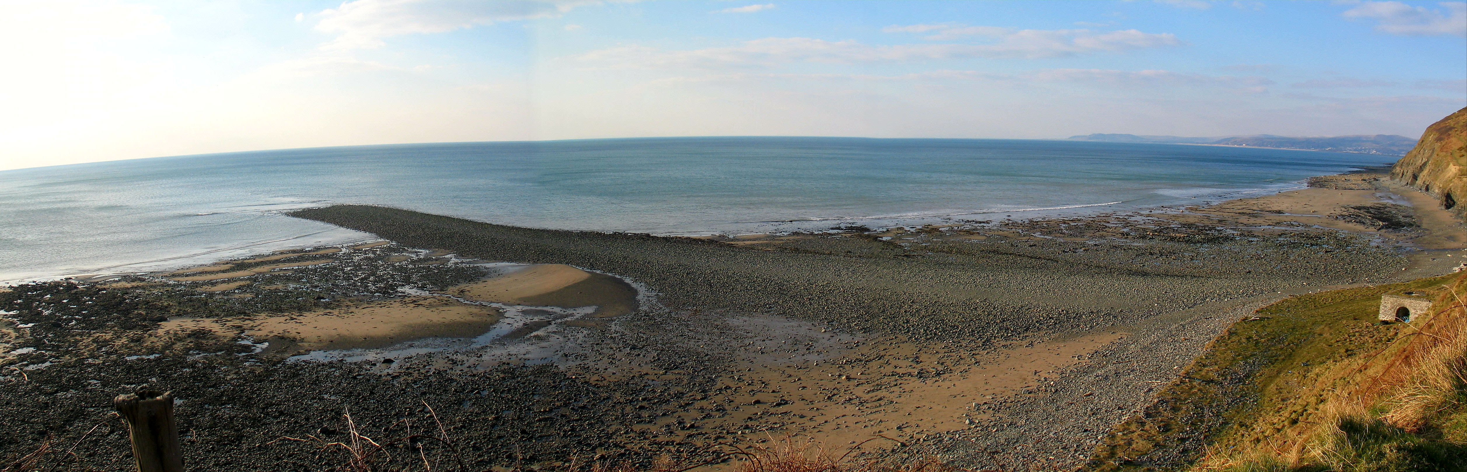
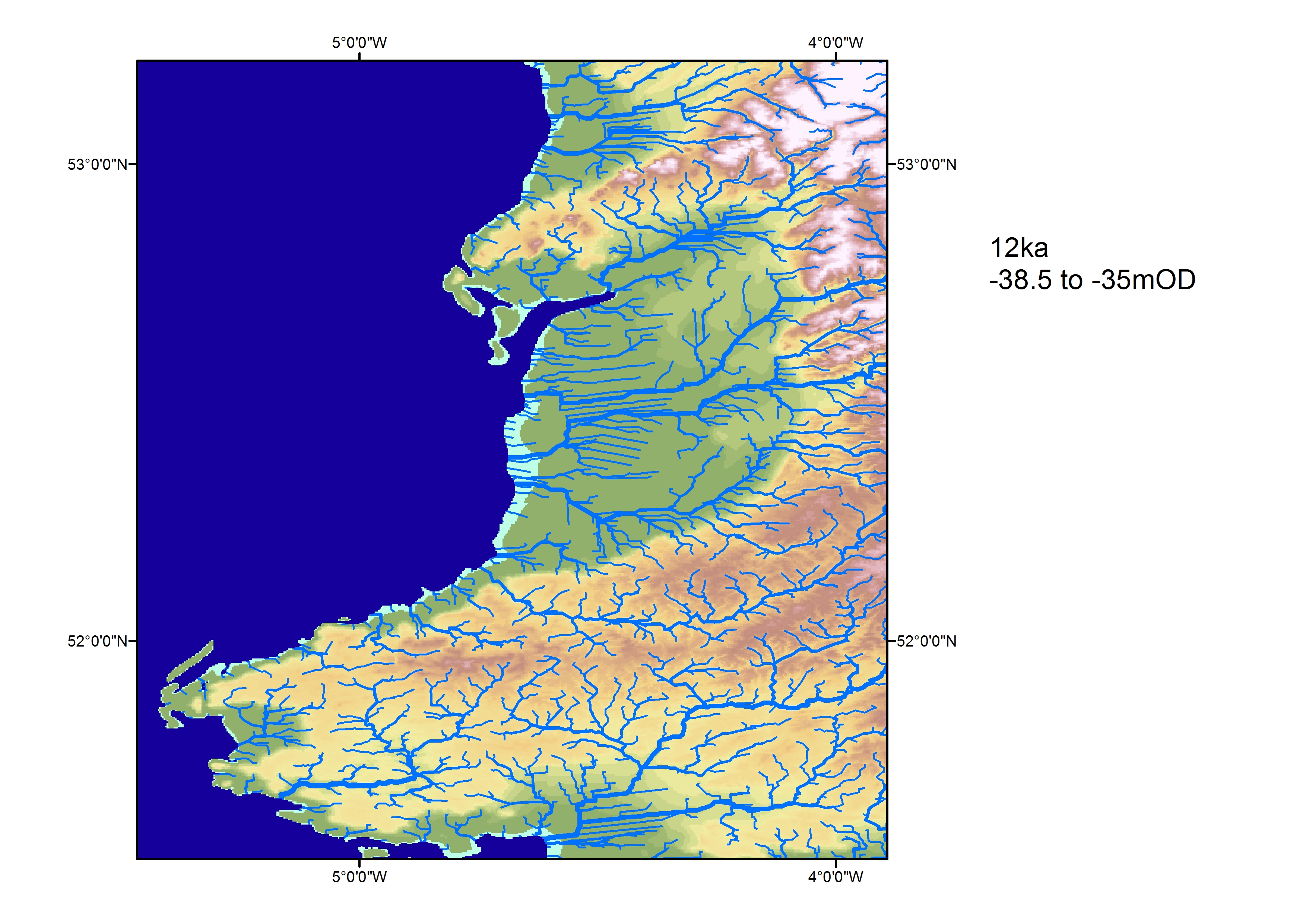
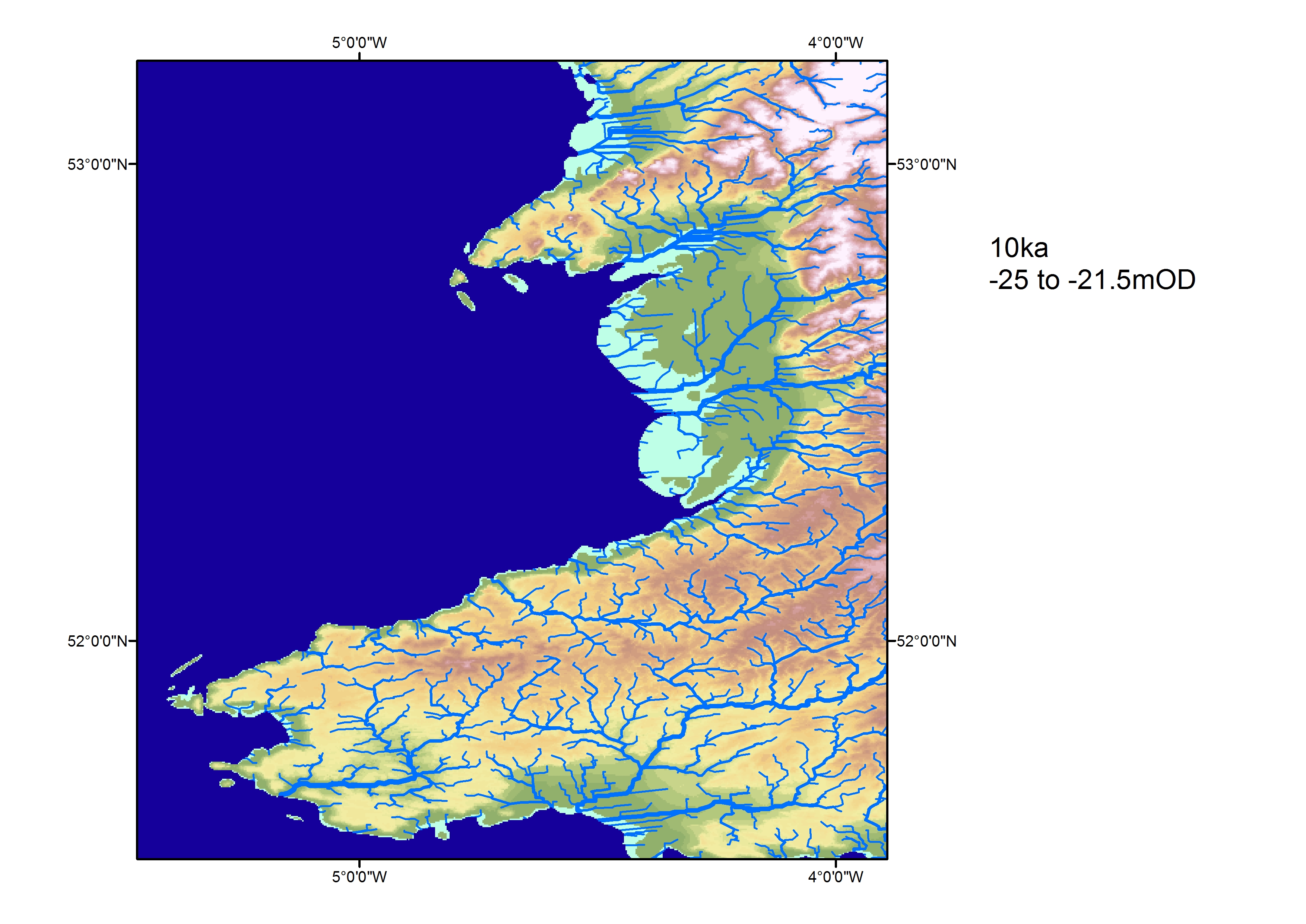
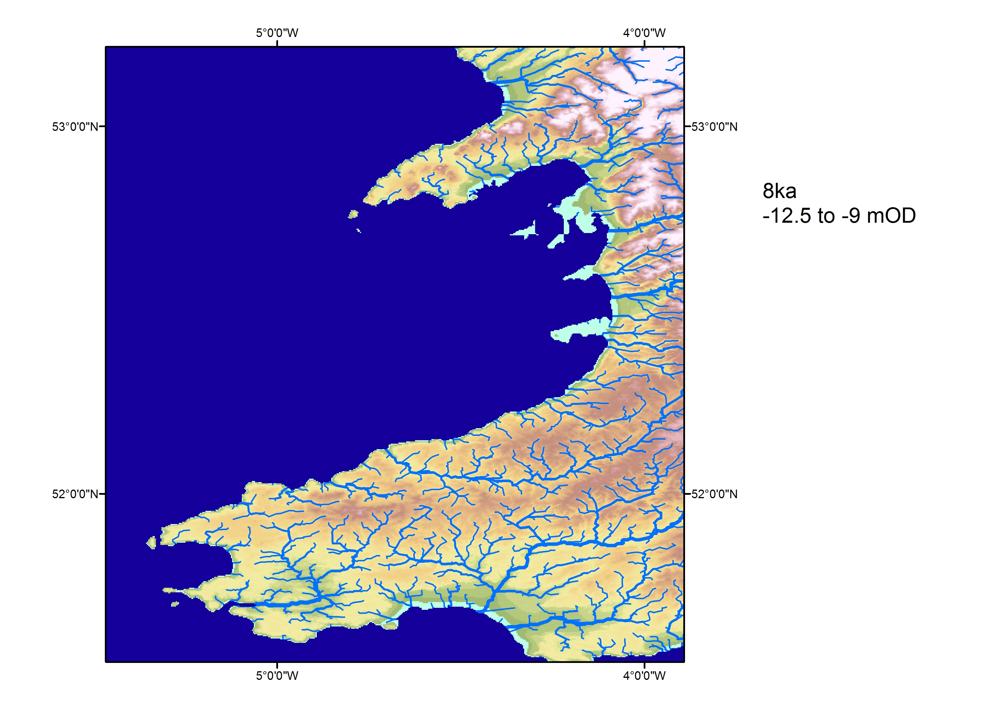
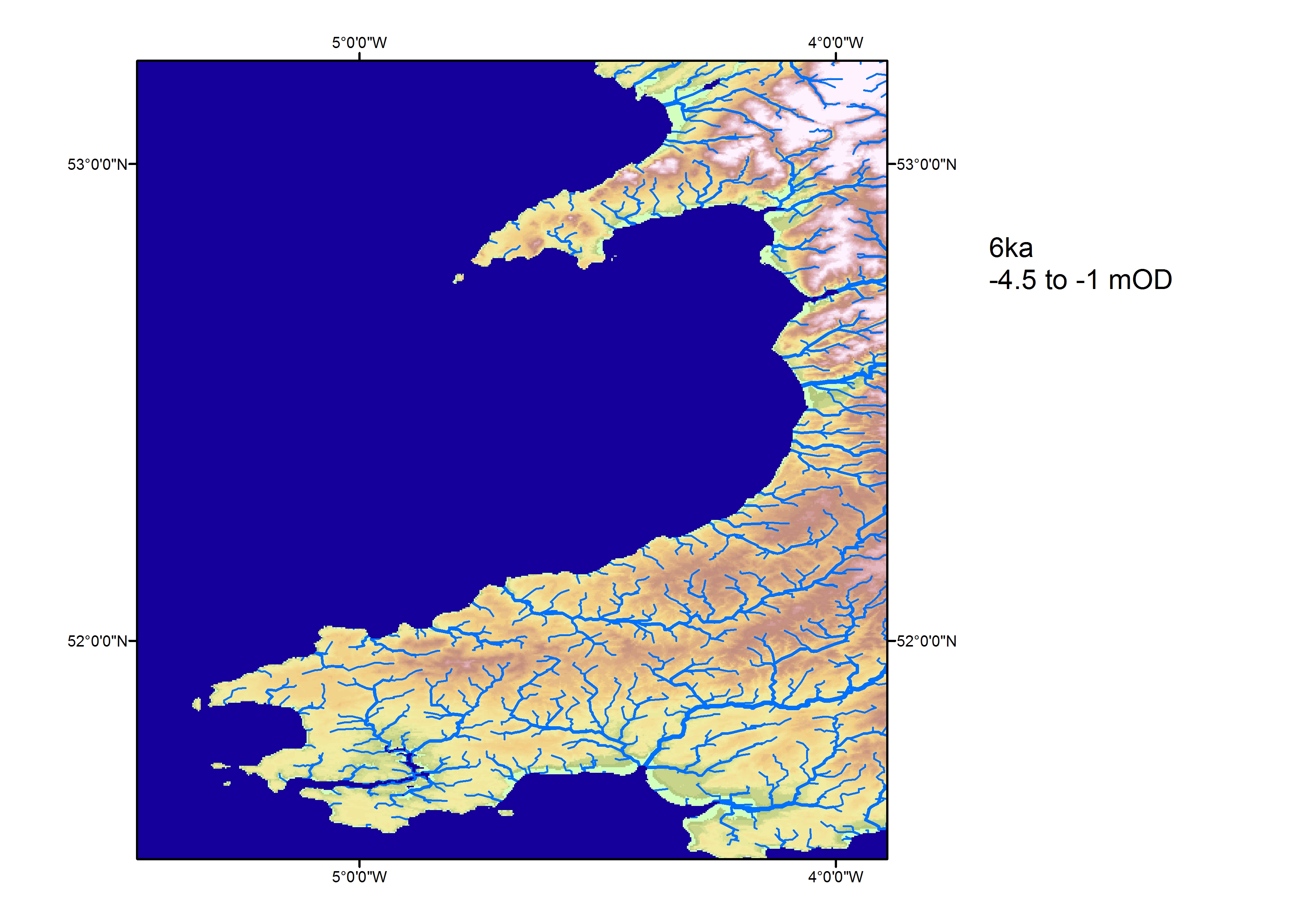
This region is the most complex of the three areas geologically because of the impact of isostatic rebound following deglaciation (Wingfield 1995; Brooks et al. 2008). Crustal depression enabled the Irish Sea to flood before 12,000 BP (Wingfield 1995) although Cardigan Bay remained dry land. As a result of sea level rise and isostatic rebound following deglaciation, Wingfield postulates the presence of a dry land bridge between the south-east of Ireland and West Wales by 11,000 BP. Over time the position of the land bridge shifted northwards, eventually disappearing beneath rising seas around 9600 years ago (however, see Sturt et al. (2013) for an alternative view). Marine waters subsequently entered Cardigan Bay and because of its low-lying topography long estuaries reached many miles inland (at Borth an estuary existed along the line of the Dyfi when the coastline was still miles to the west). The final rise in sea level resulted in the loss of remaining land in the bay and the establishment of the modern coastal geography. With the attainment of crustal stability the pattern of sea level change subsequently followed that of Area 2, with a short marine regression occurring to allow forest growth in coastal lowlands around the bay (e.g. Borth and Towyn). Marine regression occurred between 4500 and 5500 years ago resulting in a return to brackish environments. It is in this region we find not only Cantre'r Gwaelod but also the saga of Bendigeidfran's crossing to Ireland along with the local tales of Plant Rhys Ddwfn, Tyno Helig, Rhysyn and the Mermaid and The Salty Welsh Sea.
Of the local folk tales those of Plant Rhys Ddwfn and Bendigeidfran do not directly refer to a flooding event. Rather they refer to ground that is already covered by the Irish Sea. With Bendigeidfran's crossing to rescue Branwen (Z210) in the Second Branch of Y Mabinogi (predominantly in The White Book of Rhydderch, Peniarth MS4, National Library of Wales, c. 1350, and also in The Red Book of Hergest, Jesus College, Oxford, MS.111. 726.42 c. 1400) we find the Irish Sea shallow enough that while the host sails he is able to wade across from Harlech to Eire:
'Bendigeidfran and the host of which we spoke sailed towards Ireland, and in those days the deep water was not wide. He went by wading. There were but two rivers, the Lli and the Archan were they called, but thereafter the deep water grew wider when the deep overflowed the kingdoms' (Jones and Jones 1993, 28).
Could this be because the sea at the time was shallower than it is today? In this context we might refer to Wingfield's (1995) reconstruction of the flooding history of the Irish Sea postulating a shallow, northward migrating strip of land linking Britain to Ireland. Or is Branwen's regal brother being alluded to as a giant (Z261) due to his great power and presence, rather than due to literal stature? In which case, his narrated ability to cross unaided could be representing his ability to cross by his own means, without the aid of supporting forces.
The watery landscape featuring in Plant Rhys Ddwfn may be equally allegorical. Here we have a kingdom under the reign of King Rhys the Deep (Rhys 1901), situated some way out into Cardigan Bay. The dwellers on this isle are said to be like the Phoenicians, traversing the oceans to trade, including with the inhabitants of Cardigan with whom they barter their goods for grain. They sail in to harbour in boats made from trees, the pillaged trunks of which landlubbers can spy beneath the waves at low tide. Nobody on land can see from whence they have come, their rich and peaceful land is invisible (F742) unless one stands on a certain patch of herbs on a high bank, after stepping from which one immediately forgets where the herbs were (F235.5), thus protecting the fairy-like inhabitants from invasion (Gwynionydd 1858). The fields and cities of this land are also seen by ships coming in to land on the Cardigan coast, though no other ships are ever cited.
Could this then perhaps be a story about sea-gypsies, or the Irish? Certainly, the locals of Cardigan Bay were none too pleased to encounter the dark-haired children of Rhys, putting up the prices of their grain to prevent them from purchasing any food, which would be consistent with a traditional attitude towards the Romany. Or is this an esoteric tale wherein the Welsh fairies, with whom Plant Rhys Ddwfn are now synonymous, live in a parallel reality to ours, symbolised by the sea? Or, is this the bastardisation of a memory from when there was a different type of people living out where the water now rules.
By contrast, both Rhysyn and the Mermaid, and The Salty Welsh Sea, published recently from the story teller Peter Stevenson (Stevenson 2014) speak directly of inundations. In the first of these, taken from the Myra Evans Collection (unpublished) a vindictive mermaid (B81) falls in love with handsome Rhysyn. After initially being curious he eventually decides that he does not return her favours and chooses to marry a local lass from on land instead. The enraged mermaid curses him (B81.13.8), his bride and the wedding's congregation and they are all swept away in a raging tide, leaving nothing but the bereft walls and the sound of church bells ringing beneath the waves of Carreg Ina.
In The Salty Welsh Sea we find a variant on a popular tale wherein a folk explanation is offered for why the sea is saline (A1115). Stevenson tells us of three brothers, one who ploughs the land, one who ploughs the sea and one, the youngest, who ploughs only his own poor talents as an artist. Furiously fed up with his brother free-loading, the eldest gifts him a pig and tells him to 'go to Blazes'. The lad does, literally, as he is told and in so doing barters successfully for an enchanted handmill (D829) with which he proceeds to magic himself a house and enough riches to sustain his simple ways. In the course of the story both older brothers come across the enchanted house and get their little brother drunk, then tricking him out of his handmill (D830; D861.3), which they do not know how to use, thus bringing calamity upon themselves. The first brother's calamity comes in the form of a 'river of beer' that washes him away among mermaids fair, the second brother's calamity comes in the form of a river of salt that drowns his ship and makes the sea too salty to drink when the youngest brother awakes from his inebriated slumber and seeks refreshment, encountering the flood and disaster that his magic has created. The handmill is lost on the seabed (D860), where it awaits another brother to find it again one day.
North of there, between Conway and Flintshire, near Ormes Head and Penmaenmawr, is believed to lie the lost land of Helig ap Glannawg, who is alleged to have lived in the 6th century. The Halliwell Manuscript, believed to date from around eleven hundred years later, makes the first literary reference to Llys Helig, which is now the name of a rock formation by Penmaenmawr. The manuscript also calls Helig himself the 'Lord of Cantre'r Gwaelod'. His daughter, Gwendud, fell in love with a commoner, Tathal, who she was forbidden to marry because he did not wear a golden torc. Tathal went out and killed a lord in order to steal his golden torc, confiding in Gwnedud of his crime. She colluded in burying the body into the sea, during which they heard a ghostly voice curse them, assuring that revenge would one day befall the family. That day eventually came and the court of Helig was flooded overnight and the only survivor was a lonely harper. It is easy to imagine that tale being told by just such a harper, as if he were the one survivor. In some versions, however, the daughter is not mentioned and the kingdom is flooded due to the cruel actions of Helig towards his people, who survived when he did not.
That it is beyond doubt that dry land once extended north of this Welsh coastline is confirmed by the geological evidence from the Llandudno to Rhyl sector of coastline for submerged forests (Strafford 2013) and these deposits are also known to contain later prehistoric material (Glenn 1935; Manley 1989; Smith et al. 2002). Fitch and Gaffney (2009) have also demonstrated that submerged landscapes similar to those of Doggerland are present offshore from this area.
Further north again, the Reverend William Thornber writes in his History of Blackpool (Thornber 1837) that in 1554 the village of S(h)ingleton Thorp, in Cleveleys, Lancashire, was swept clean away from Rossall Point, causing the villagers to take refuge in nearby Singleton. This is one of many similar stories along this stretch of coast, but all that is said to remain of this particular hamlet is a cobbled lane leading into the sea, sandwiched between the decaying trunks of a forest. In some versions at low tide can be seen a 'Penny Stone' by which the villagers had tethered their horses at their Inn and from which the tale gets its name. Fisherman are said to still fear the ghostly laughter of the Inn's revellers intermingling with the submerged tolling of church bells.
Area 3's sea stories end on the Isle of Man, where we find The Moving Island, Port Soderick and The Undersea World of Port Erin. The first two of these speak of Mona being an island whose size and exact location were transient, with sands that rose and fell from the sea, a characteristic so distinctive that the 17th century historian William Blundell wrote of it as being symbolised as a ship in the Manx coat of arms:
'I believe the old Arms of the Isle of Man was a ship — yea, and y'most meet and fitting, first, because, floating in the ocean, it much resembleth a moveable island and an island resembleth a ship fixed there' (Blundell 1648-56).The third tale speaks of a diver who claimed to have discovered an undersea land of jewels (Waldron 1726), described as surely being a land once flooded by time? While this is now commonly interpreted as probably being a reference to the submerged coral reef of St Mary's isle, it still offers us an example of possible 'myth by observation' (Tyler 1865).
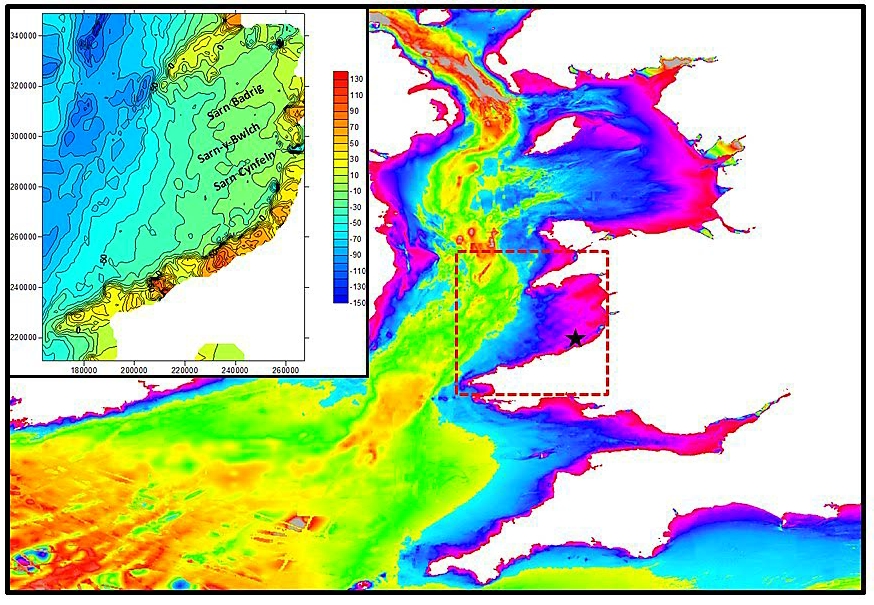
This article began by focusing on the story of Cantre'r Gwaelod and so we return to Cardigan Bay to investigate in more detail both the stories and the geological history of the region. Attempting to understand the structure of the pre-inundation landscape in Cardigan Bay (Figure 1), how and when the landscape flooded and what happened around the coasts of this flooded landscape is complex and at present we lack sufficient evidence to adequately reconstruct the evolution of the bay. However, despite this paucity of data there are a number of different sources of information that do exist, including bathymetry for the seabed (Figure 8) and isolated cores also taken from the seabed that can help create a narrative for flooding.
The bathymetry of the bay is presented in Figure 8. This bathymetry represents the form of the modern seabed, which includes structure inherited from pre-inundation topographic features as well as from processes operating on the seabed since inundation. Consequently, we cannot simply treat the bathymetric map as a map of the pre-inundation landscape. However, despite these misgivings the basic topographic shape is likely to broadly reflect the relict landscape of the early Holocene. Thus, we can pick out likely valley forms and 'higher ground' away from the valleys; significantly we can see the position of the three 'Sarns' (Figure 8, inset, and Figure 9a). We can subsequently use this topography to plot the likely inundation history of the bay using the sea level curve of Lambeck (1995), i.e. sea level attaining -37m around 12,000 years ago rising to -10m just about 8000 years ago (Figure 10). This evidence indicates that modern geometry of Cardigan Bay had been established by 7500 BP (within the later Mesolithic period) and subsequent sea level rise to 6000 BP simply drove the shoreline landwards.
In order to establish direct evidence of inundation, cores from the seabed are required to provide material documenting the flooding events. Haynes et al. (1977) published a sequence of events inferred from biological material (foraminifera, ostracods, diatoms and pollen) from a core drilled in the seabed off the Aberaeron coast (Figure 11) where a sequence of deposits recording the flooding event (marine transgression) was present. The core samples indicated that a relatively benign transition from a terrestrial marsh (peats and organic silts) to estuarine mudflats and subsequently marine conditions is documented. A single date of 8740±110 BP has been recorded from the peat indicating flooding at some time after this. Boreholes from Borth (Prince 1988; Shi 1992; Shi and Lamb 1991) also document the marine transgression and the onset of brackish water conditions in the Dyfi at the lower elevations of about -24m OD. As at Aberaeron initial conditions suggest the gradual onset of brackish conditions rather than a catastrophic event causing inundation.

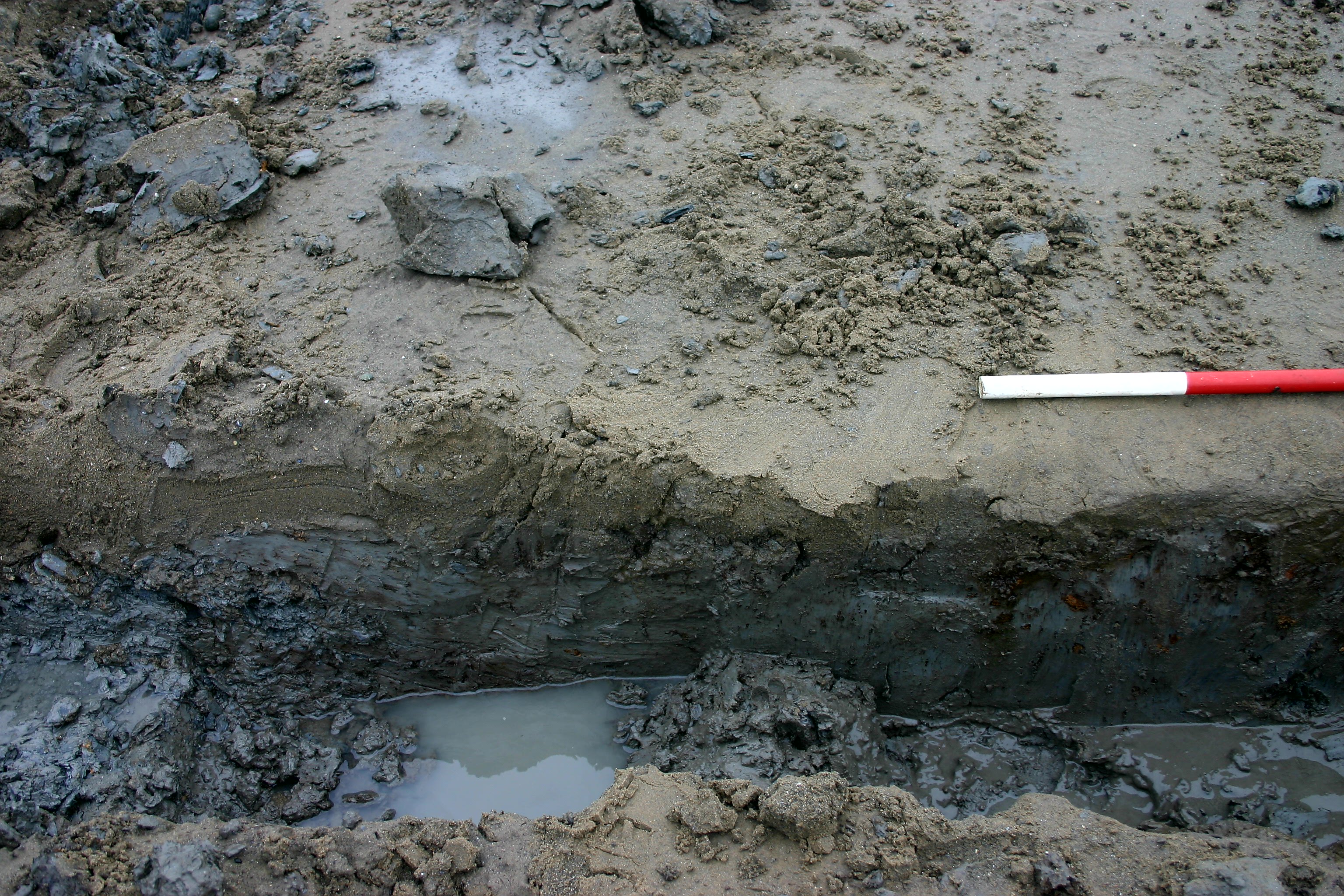
At Borth, following the initial flooding event, a prolonged period of intertidal and sub-tidal conditions prevailed for over two thousand years before a marine regression (Adams and Haynes 1965; Haynes and Dobson 1969) is documented by the expansion of extensive peat deposits first noted by Edward Lhuyd in 1695:
'As for the roots or stumps I have observed them myself betwixt Borth and Aberdovey … they appeared more like cole-black peat than timber' (Condry 1981).

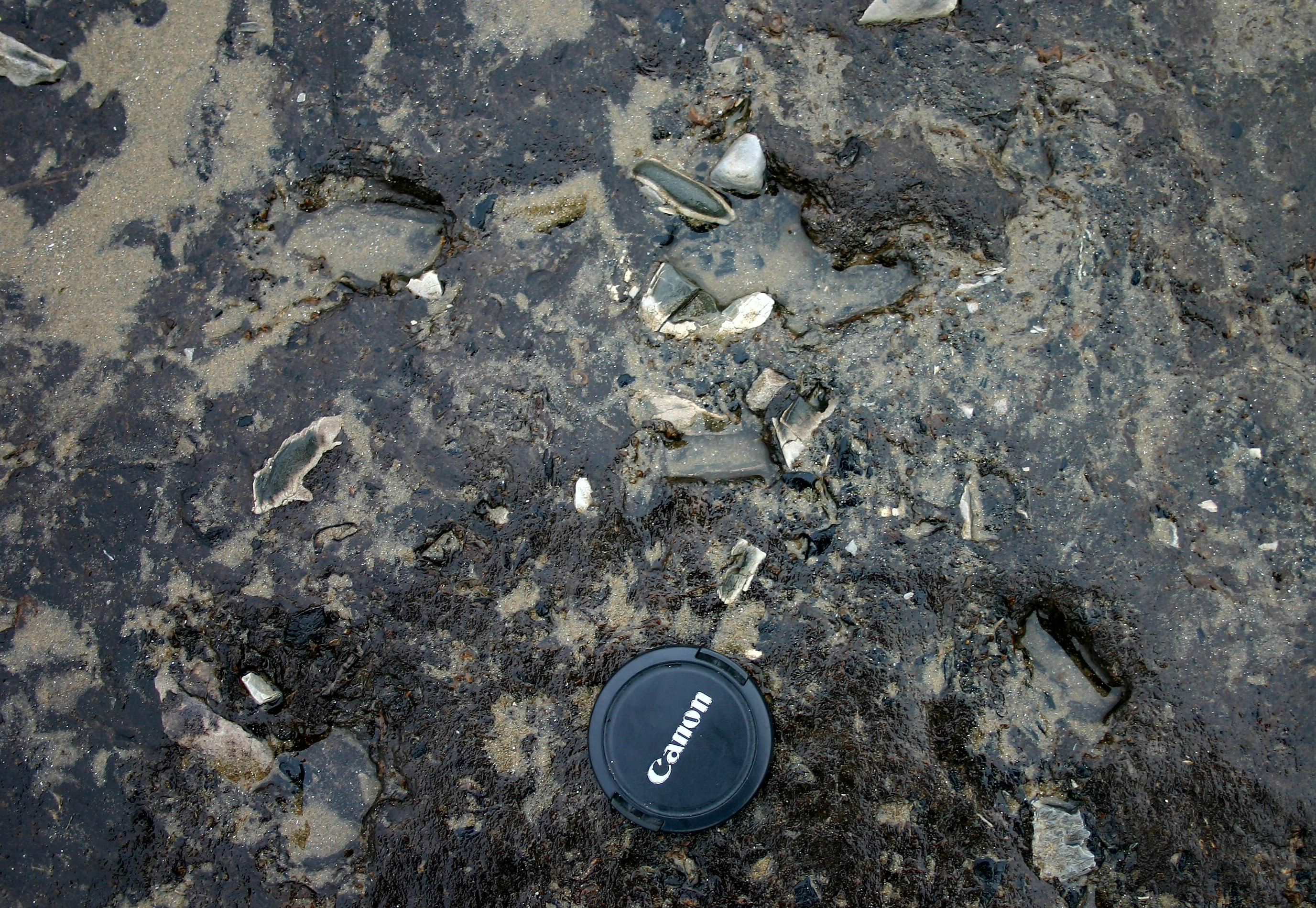
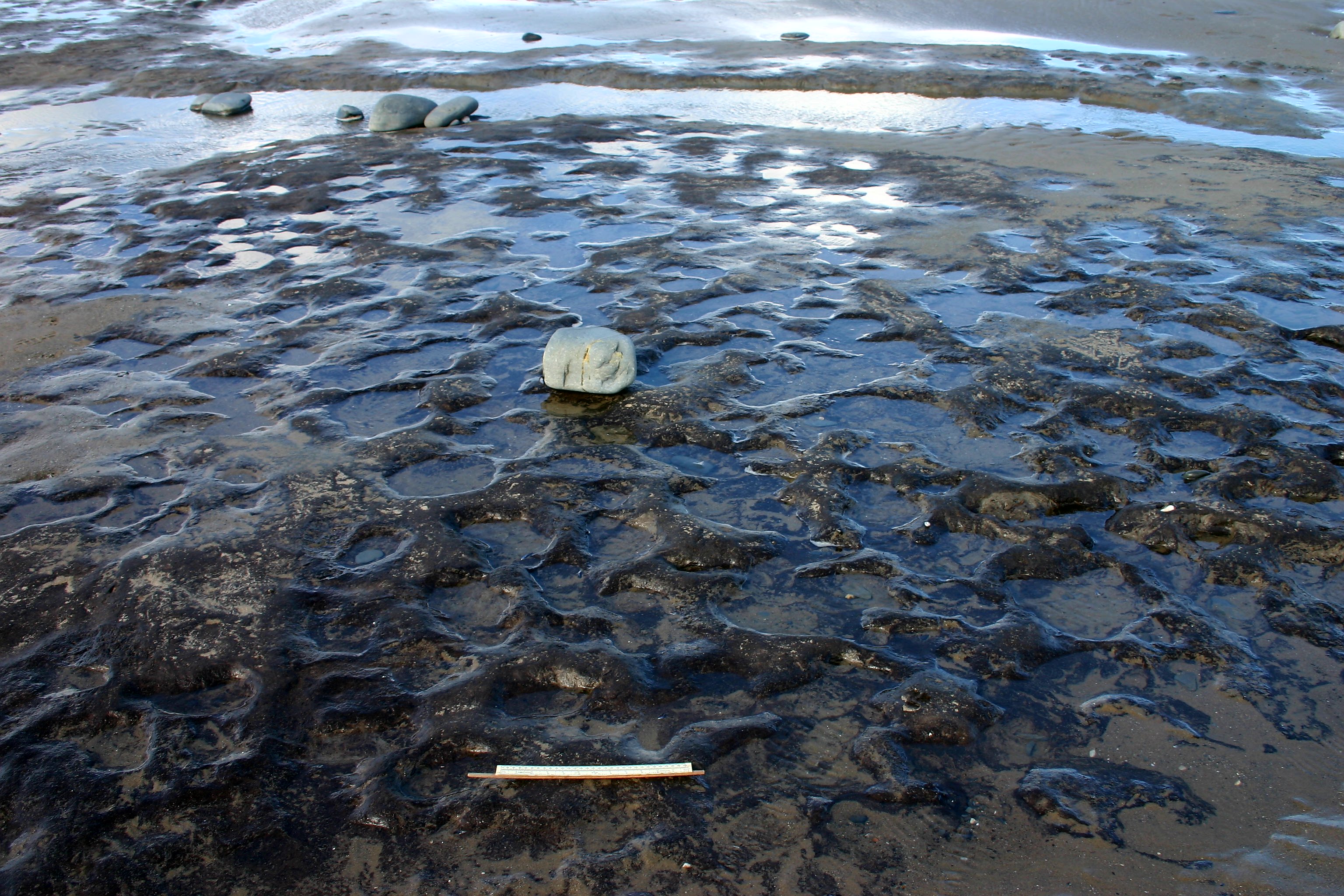
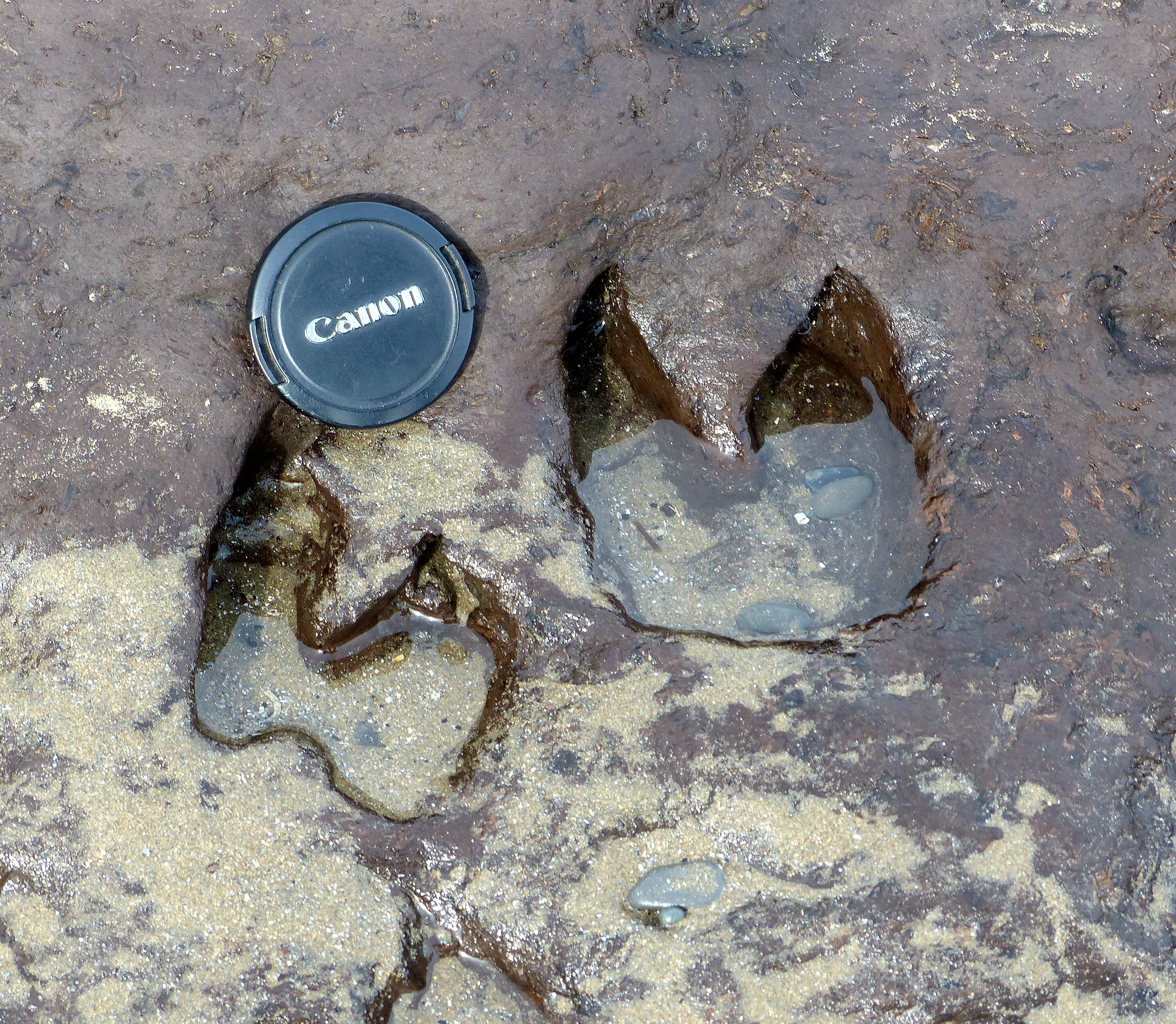
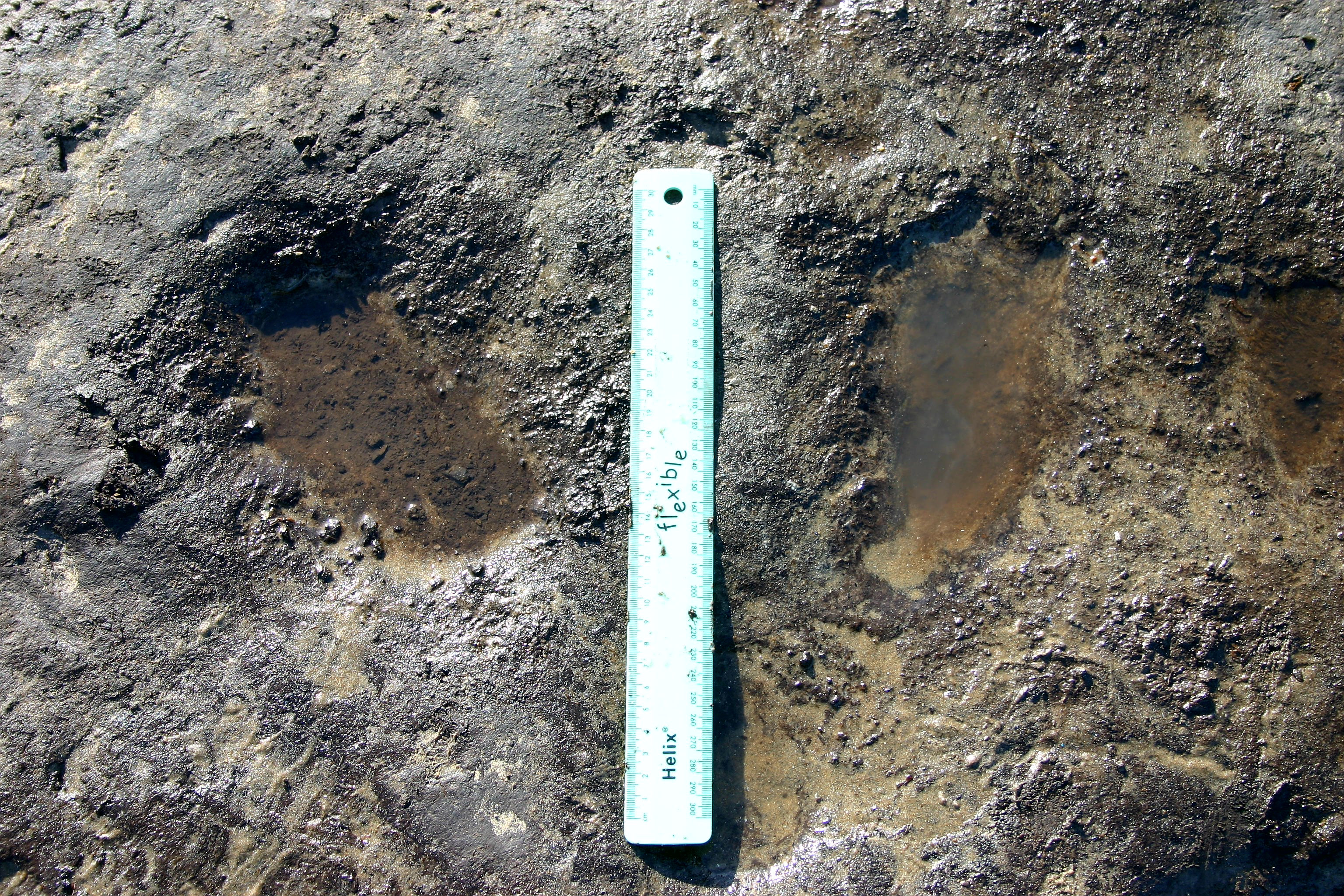
The first detailed reports were by Keeping (1878) and Ashton (1920) (Figures 3 and 9b-c). Detailed investigation of the peats has been undertaken by Godwin (1943; Godwin and Newton 1938), Moore (1966), Wilks (1979) and Heyworth (1985). Trees in the peat include oaks and pines and have been dated to between 6000 and 4700 years ago (Campbell and Bowen 1990). Finally, a return to brackish water conditions ensued although little is known presently of the flooding scenario at this time; however, recent observations at the south end of the beach at Borth (Figure 9b) indicate fluctuating conditions between peat and clay silt deposition at the top of the main peat bed; these may have characterised a gradual or episodic flooding of the forest. Evidence of human occupation in the peats is rare and scanty although clusters of burnt stones have recently been reported from the top of the peat (Figure 9c) while possible brushwood structures have also been revealed but as yet remain unpublished. Sporadically, vertebrate remains are reported from the area, most spectacularly the discovery in the late 1960s of a near-complete skeleton of an auroch (Taylor 1984) and recently a magnificent set of red deer antlers (Figure 12), but more commonly footprints of both animals and humans (Figure 13a-c) have been seen. The human prints vary in size from children to adults and are randomly orientated within this mass of prints. Nothing about the prints indicates the direction of movement of the people or animals, rather that they were 'milling about', perhaps around a watering point or space within the submerging forest. Taken together the various lines of evidence enable the projected coastal configurations from the Holocene flooding event to be modelled (Figure 10a-d).
What, then, is the relationship of this scientific narrative to those of the stories associated with Cantre'r Gwaelod? This latter story first appears in print within a praise poem contained inside The Black Book of Carmarthen (Anon, National Library of Wales, 53b-541) dated to no later than around AD 1250. The text is entirely in medieval Welsh, the most prevailing scholarly translation of which by Rachel Bromwich is as follows:
Stand forth, Seithenhin,
And look upon the fury of the sea;
It has covered Maes Gwyddneu.
Accursed be the maiden
Who released it after the feast;
The fountain cup-bearer of the raging sea.
Accursed be the maid
Who let it in after the battle;
The fountain cup-bearer of the barren sea.
The cry of Margaret from the battlements of the fortress to-day,
Even to God is uttered;
Usual after presumption is utter loss.
The cry of Margaret from the battlements of the fortress today;
Even to God is its supplication;
Usual after presumption is repentance.
(Bromwich 1950, 217)
The similarity here to Ker Ys is unsubtle, a point that Bromwich goes on to discuss in detail, along with what she sees as being the questionable notion of the narrative being set in Cardigan Bay, with her confident view being that the original site was in the Northern Kingdoms (Bromwich 1950, 223). She also offers corrections to the characters and explanations for the different literary accounts via translation and reference to other scholarly works such as those of Samuel Rush Meyrick (1783-1848), Sir John Rhys (1891) and Ifor Williams (1942), tying in the Hanes Taliesin and paralleling the poem also to that of Tyno Helig.
That the tale has been absorbed into Ceredigion is unquestionable. The full name for Borth, where the forest has recently shown its wares so dramatically, is Porth Wyddno yng Ngheredigion (Rhys 1891, 263) and according to Bromwich (1950), Meyrick is explicit in his geographical referencing, beginning the Lost Lowland from the submarine causeway of Sarn Badrig in the north-west between Harlech and Barmouth (Figure 8), possibly under the very stretch of water where Bendigeidfran is said to have waded, to Cardigan in the south. There are two more causeways nearby — Sarn Bwch by Aberdysini and Sarn Cynvelyn by Aberystwyth (Figure 9a), the latter being alleged to end in Caer Wyddno. The observation of these three natural features could perhaps not unreasonably have given rise to the folk notion of there once having been dykes in the region.
Whether or not the flooding events so well documented in the geological record (either the initial inundation of the bay area or the more localised changes associated with the creation and subsequent destruction of the submerged forest at Borth) can be linked to any of the elements of flooding in our stories remains problematic. It is curious that the most prevalent of our tales do not directly speak of a drowned forest, which is surely the most striking of the natural features along this shore. Today the stumps of oak and pine trees can be found exposed on the foreshore (particularly after storms) from not only Borth/Ynyslas (Figure 3), but at many locations along the Welsh coast (Strafford 2013), and are the source of many a fledgling narrative. One such segued through Peter Stevenson's The Railway Wave, a story that came about during the January storm of 2014. Peter was standing outside Borth station regaling a group of theatre, film and visual art students from Coleg Ceredigion with the wonders of The Lowland Hundred when a giant wave arose from the sea and soared above his head, engulfing the railway station, the students, Peter and his voice. The teenagers left Borth sodden and inspired, their ensuing response to the flooded-out flood tale including a short film where each stood as a tree on the shore, disappearing into time with Seithenin and Mererid (Baudey 2014). Thus, we see how a narrative can morph and ricochet into new interpretations, being born and reborn autonomously. In this tale of a tale's creation the carcasses of trees went from an incidental to a primary role, whereas with the 'Penny Stone' they exist as an epilogue, an archaeological support to the assertions made and so from this we see how one type of natural feature can take many roles within different narratives.
The similarities between this area's stories is unsubtle, especially those of Cantre'r Gwaelod and Ker-Ys/Caer Is; both even being translatable to the same meaning. Add more than a passing nod towards Lyonesse' 'Tristan and Isolde' and the mention of Sennin/Seithenin Cove in Cornwall then add the parallels between Helig and Gwyddneu's daughters in relation to victim disposal, and the question of how and why it all inter-relates seems unavoidable, to the extent that Bromwich proposes that in each aspect of this medley the post-Roman element is surely significant, for:
'it was to representatives drawn from among the famous legendary heroes of the sixth century, the period assigned to the beginning of their national traditions, that medieval cyfarwyddiaid attached the legends of the great inundations' (Bromwich 1950, 241),
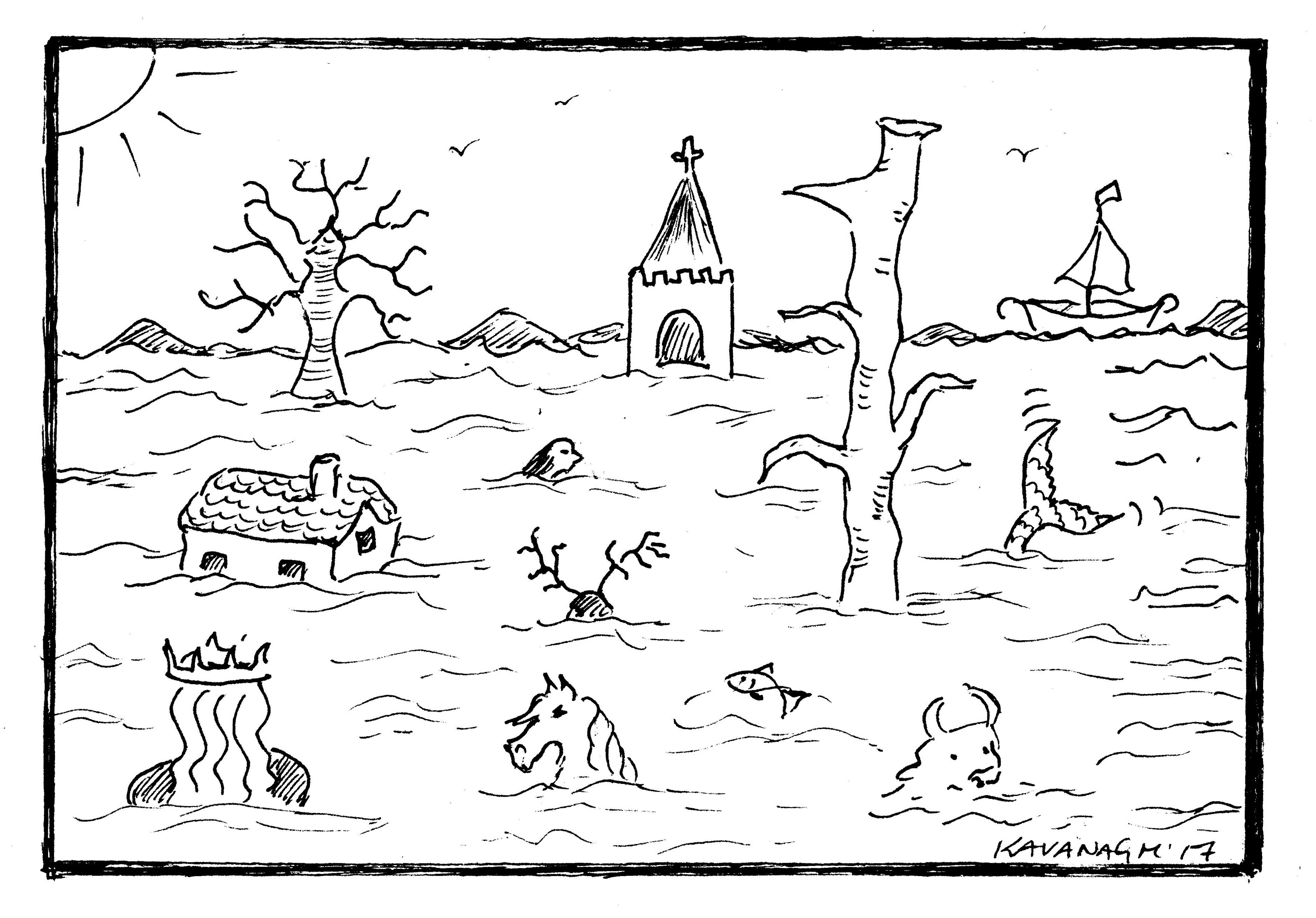
Legends, tales, mythologies that morph in and out of each other's narratives into a palimpsest of shape-shifting variations chasing their tails, is worthy of a paper in its own right. What it serves to offer us here is a perfect example of a movable flood via the organic process of bardism at its chaotic and creative best (Figure 14).
Cite this as: Kavanagh, K.E. and Bates, M.R. 2019 Semantics of the Sea — Stories and Science along the Celtic Seaboard, Internet Archaeology 53. https://doi.org/10.11141/ia.53.8
Internet Archaeology is an open access journal based in the Department of Archaeology, University of York. Except where otherwise noted, content from this work may be used under the terms of the Creative Commons Attribution 3.0 (CC BY) Unported licence, which permits unrestricted use, distribution, and reproduction in any medium, provided that attribution to the author(s), the title of the work, the Internet Archaeology journal and the relevant URL/DOI are given.
Terms and Conditions | Legal Statements | Privacy Policy | Cookies Policy | Citing Internet Archaeology
Internet Archaeology content is preserved for the long term with the Archaeology Data Service (ROR). Help sustain and support open access publication by donating to our Open Access Archaeology Fund.