Cite this as: Hegyi, D. and Nádai, Z. 2020 Investments for Visitor Purposes at Archaeological Sites and Historical Monuments in Hungary, Internet Archaeology 54. https://doi.org/10.11141/ia.54.6
The period after World War II is traditionally viewed as the golden age of Hungarian monument protection; both the institutional and legal frameworks were progressive, even in a European context. However, the considerable success of this era is somewhat overshadowed by its negative consequences, which remained unaddressed after the political regime change following the collapse of the Soviet system. Transformations made necessary by the changing functions of sites, in-building, the division of these areas, as well as the lack of proper professional management have had an impact on sites. Long-term strategies are crucial, but hampered by the present project-based financing system. The tasks of the National Program for Mansions and Castles have been divided between several institutions and state-owned companies: project planning and coordination belongs to NÖF (Nemzeti Öröségvédelmi Fejlesztési), while research-related tasks are subdivided. Academic documentation of garden history is done by professionals at NÖF, the remains of walls are researched by the Heritage Protection Documentation Centre, Hungarian Museum of Architecture, Hungarian Academy of Arts (Magyar Művészeti Akadémia Magyar Építészeti Múzeum Műemlékvédelmi Dokumentációs Központja, MÉM-MDK), while restoration of the artefacts and monuments as well as the preliminary archaeological documentation (Előzetes Régészeti Dokumentációk, ERD) are undertaken by the Castle Headquarters Integrated Centre of Regional Development Ltd (Várkapitányság Integrált Területfejlesztési Központ Nonprofit Zrt., Várkapitányság Nkft.).
At some of the sites involved in the programme, archaeological surveys were a precondition for developing any concept on further planning. These explorations were undertaken as ERD-related test excavations. Castles were explored through test pits, while the study of historical gardens was carried out in co-operation with landscape architects at NÖF, as well as heritage protection specialist András Koppány (MMA MÉM-MDK).
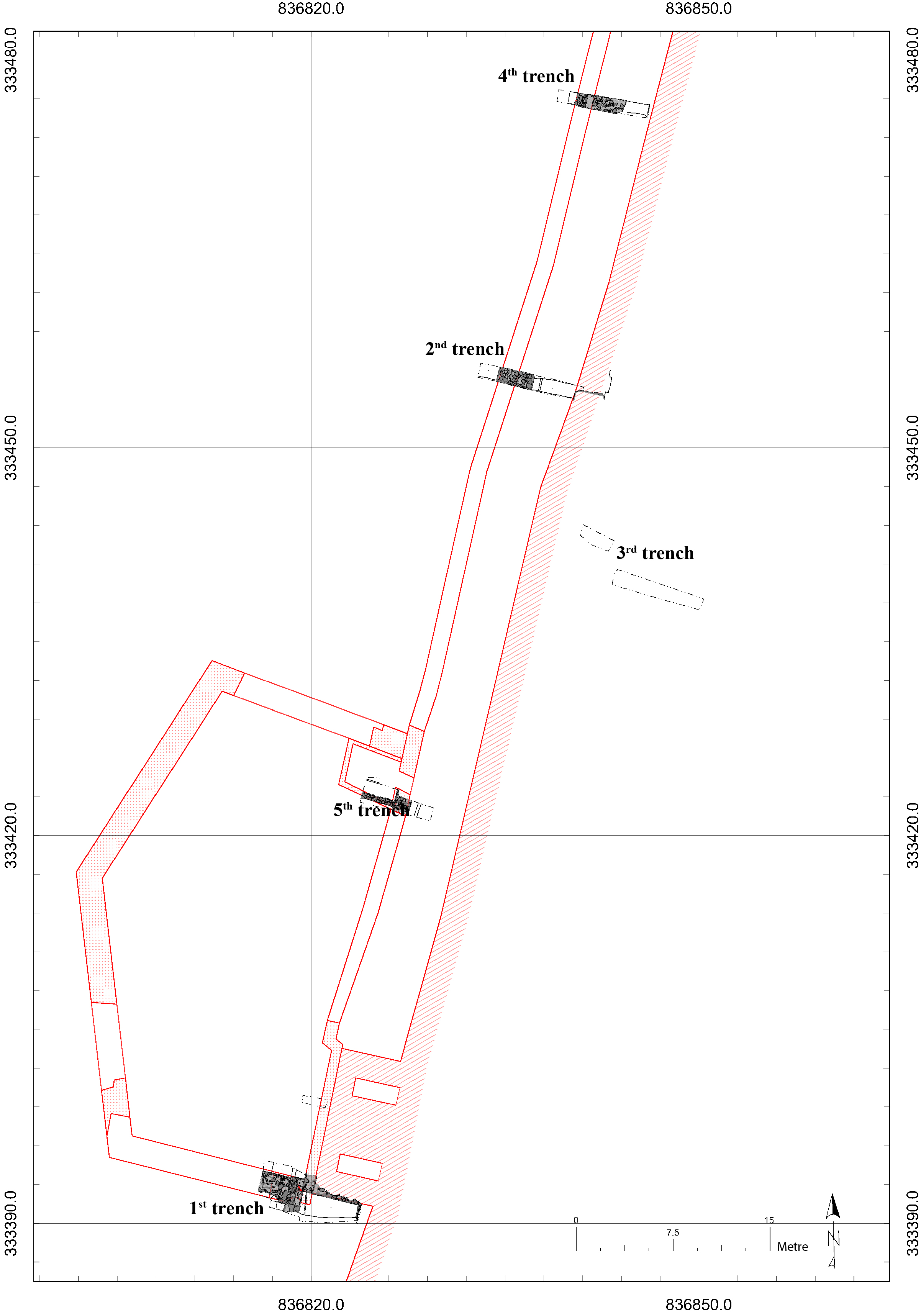
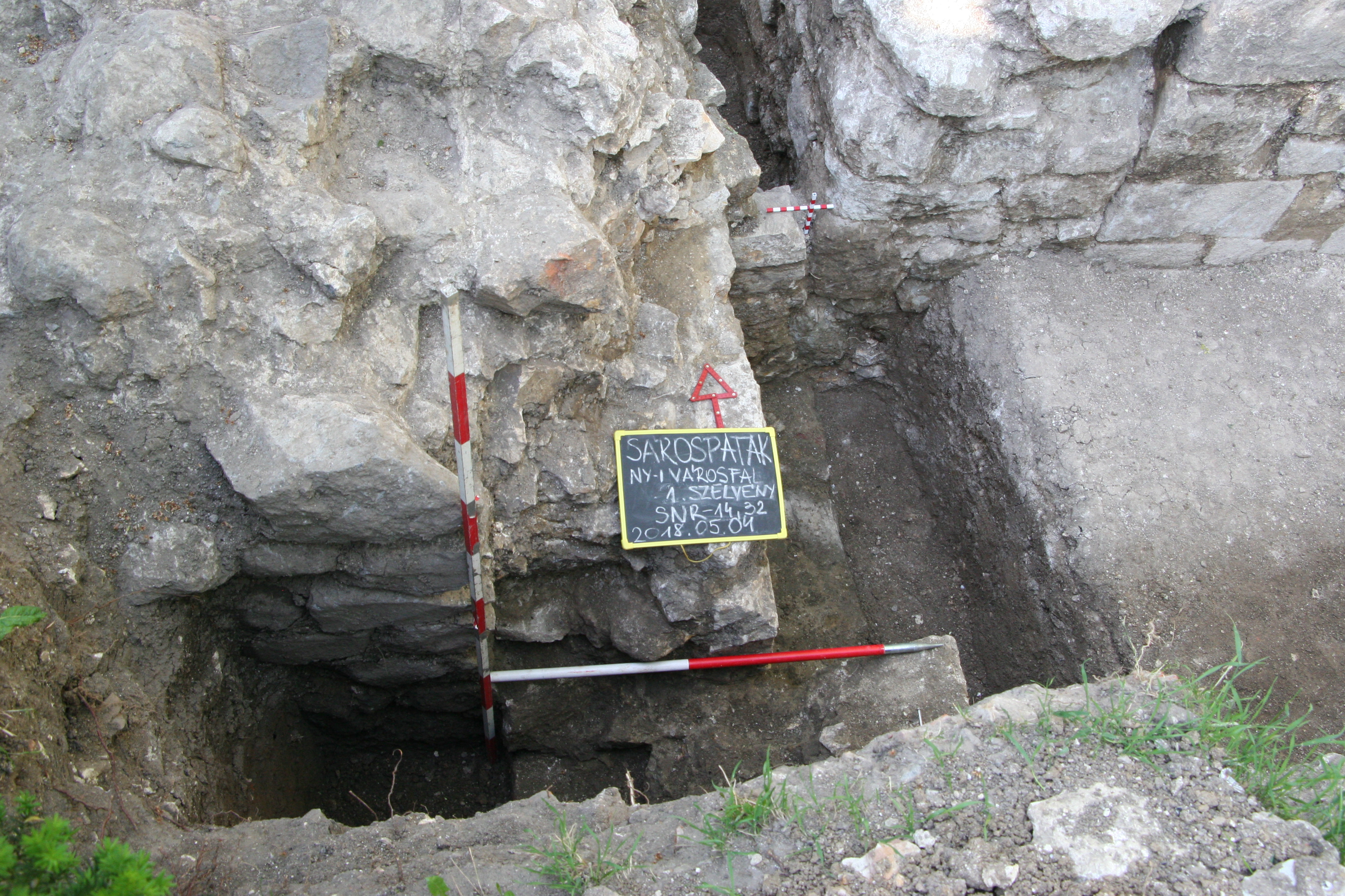
There were plans to build a promenade on the western side of the wall that once encircled the early modern town of Sárospatak. This promenade would connect the area with the already restored castle park. Accordingly, test excavations were carried out in two locations: on the external side of the western town wall, in the area of the so-called Lion Bastion in the centre, and on the internal side of the same wall, in the elevated area of the so-called Cannon hill. The intention was to identify the closure and the floor level of the zwinger – the open area between the two defensive walls – and its relation to the Lion Bastion. The aim of the plans were that the promenade's line and floor level should reflect the structure of the old fortification, and there should be a passage between the higher floor inside the town wall and the lower floor outside it.
The settlement is situated on the right bank of the Bodrog river. After the battle of Mohács in 1526, in which the Turkish armies decisively defeated the forces of the Hungarian Kingdom, Péter Perényi was one of Hungary's most powerful aristocrats. The earlier owner of the town, Antal Pálóczi, who was the last male scion of his family, fell at Mohács. His estates were arbitrarily seized by Péter Perényi. As the keeper of the crown, he was soon given deeds both by King John Szapolyai and the rival King Ferdinand of Habsburg, which confirmed him in the possession of the landed property that he had taken over on his own initiative. He received these estates as a reward for having lent the crown to both rulers for the coronation ceremonies. The castle of Siklós and Trebisov (today in Slovakia), which were the earlier residences of the Perényi family, were both in dangerous land because of the Turks and were not suitable for well-protected dwellings. With the taking of Sárospatak, he began to build a secure family seat around 1534. The castle with the Red Tower was certainly finished by 1537, because in May that year he dated a letter 'from our castle of Patak'. In the eastern town wall, there is the Water Gate. According to the inscription above the gate, the fortification was fully completed in 1541 (Feld and Szekér 1994, 182; Feld 2000; Détshy 1970, 8-9).
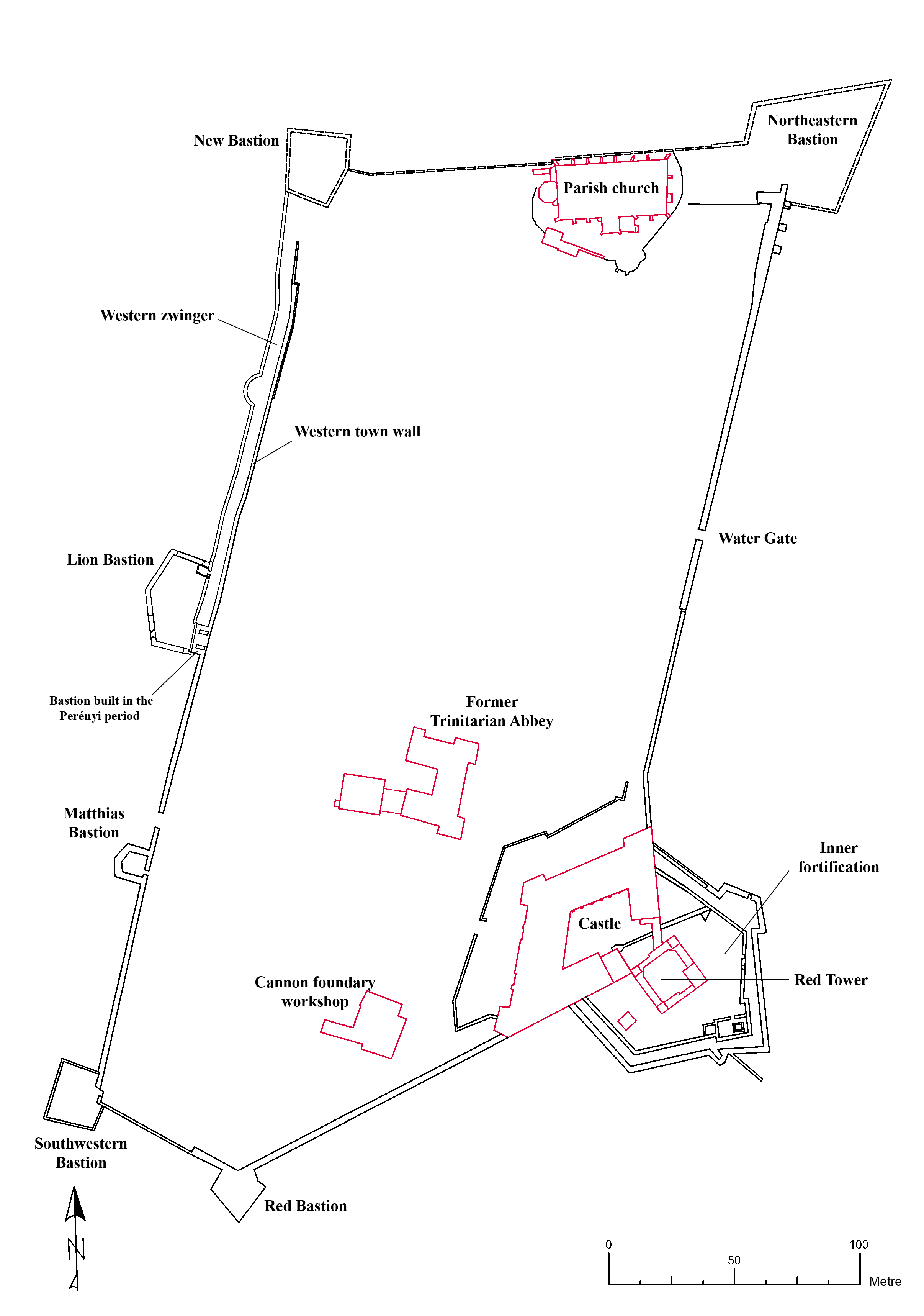
In the 17th century the town was in the ownership of the Rákóczi family, and this period is seen as a second heyday, when large-scale constructions and modernisation started, and the castle and the fortifications were enlarged. However, in 1702 the Habsburg Chamber ordered the castle to be blown up and be put out of use. During the 18th–19th centuries, the owners of the complex transformed the Red Tower and the castle wings into a romantic-style aristocratic mansion, and their environment into a landscape park. The moat around the walls was filled in and its line is perceptible today on the western side (Nováki et al 2007, 102, 104–5) (Figure 1).
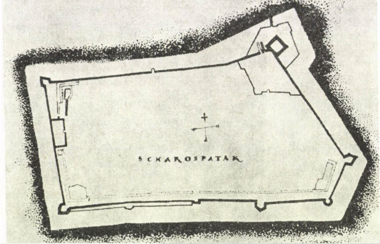
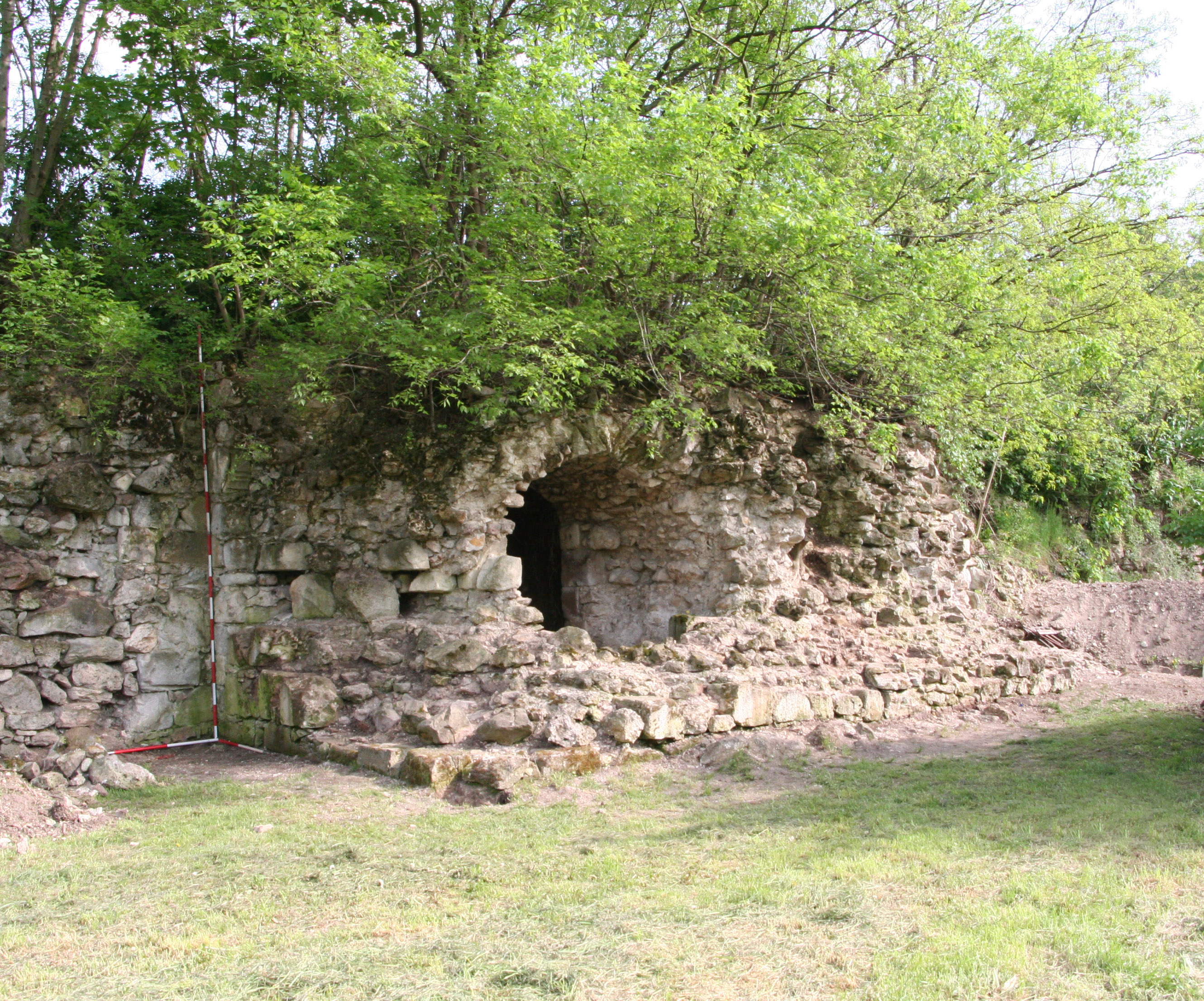
Systematic archaeological research started in Sárospatak in 1958, preceding the restoration works in the town. These excavations focused primarily on the fortified castle in the south-eastern corner of the settlement. The large-scale reconstruction project made it possible for archaeologists Katalin Dankó, István Feld and Csaba László to undertake research into the Red Tower's walls, using test pits. At the same time, further archaeological surveys were conducted in several locations of the town. The north-western New Bastion on the western town wall – important for the 2018 excavations – the south-western corner bastion, and the Matthew Bastion north of it in the castle garden, were also excavated. They were also restored after the completion of investigations (Nováki et al 2007, 103-4). North of the Matthew Bastion, the Lion Bastion was partially excavated by Katalin Dankó in 1983. This project showed that there was a double defensive wall on the northern side of the western town wall and clarified the relationship between the zwinger's wall and an earlier, rectangular bastion erected in the Perényi period. The upper floor of this latter, two-storey building consisted of two barrel-vaulted parts and a small opening between them, which was later blocked up. The two storeys were divided by a flat ceiling. On the northern and southern sides, both floors had three loopholes. A primary source of pivotal importance for the research and identification of these remains is a survey completed around 1570 by Nicolo Angelini, an Italian military engineer; this document recorded the fortifications built during the ownership of the Perényi family (Figure 2). The 17th-century structures are evidenced by an 18th-century ground plan of the town, which was also helpful when the large, pentagonal Lion Bastion was identified. An earlier bastion was incorporated into the south-eastern corner of the Lion Bastion. The two construction phases of the defence system also differ in terms of building materials. While limestone was used in the 16th century, the later builders preferred grey andesite (Dankó 1984, 242-44, 245).
Besides the archaeological and architectural research, the written sources about the town and the castle were also collected by Mihály Détshy, the architect of the first monumental restoration of the castle (Détshy 1966; 2008). For many years, the Red Tower was identified with the castle (named castrum Patak, castrum Potak or castrum Potok in some 13th-14th-century sources). This identification persisted in the historical-architectural literature for a long time. In 1966, Mihály Détshy proved that the 13th-century castle named Patak today stands on Castle Hill above the nearby Sátoraljaújhely. This castle had several owners in the 14th–15th century and it finally also became Péter Perényi's estate after 1526 (Détshy 1966, 177-97; 2008, 7-26; Ringer 2017).
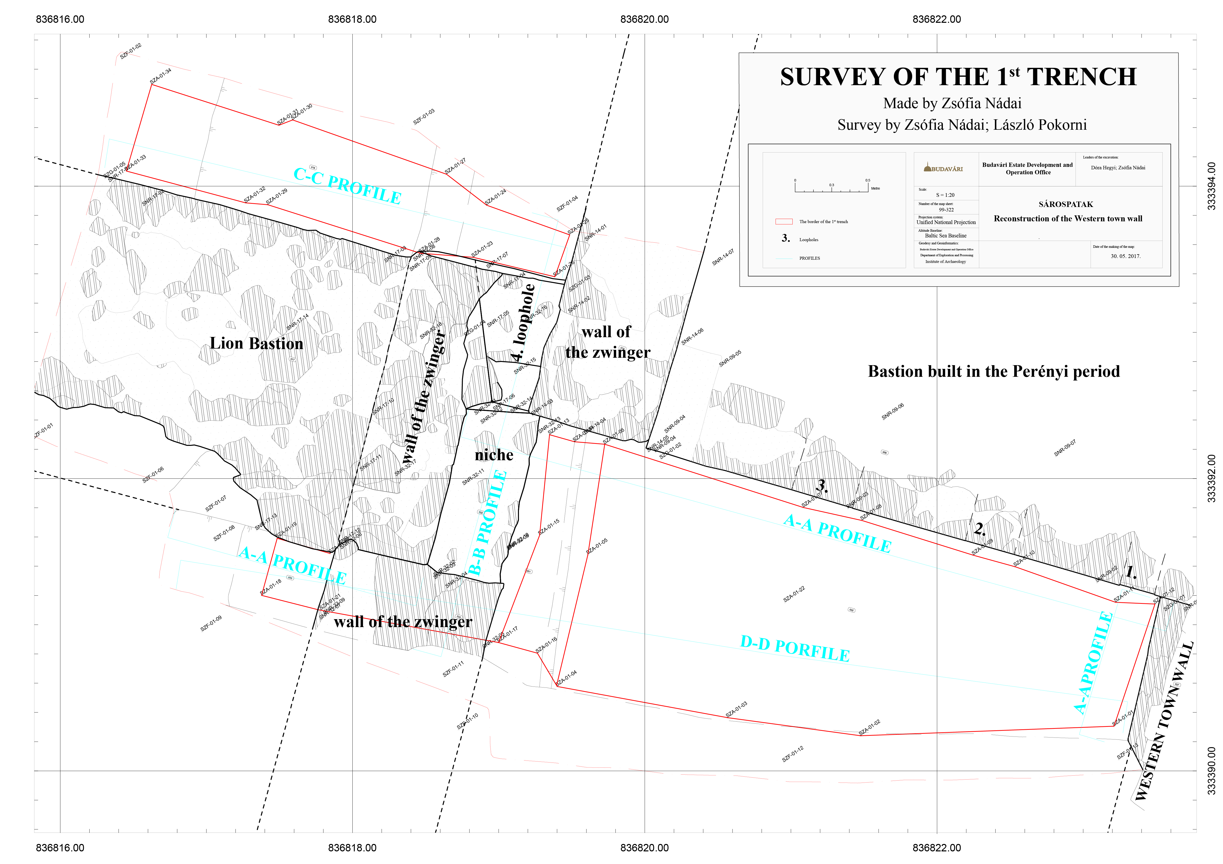
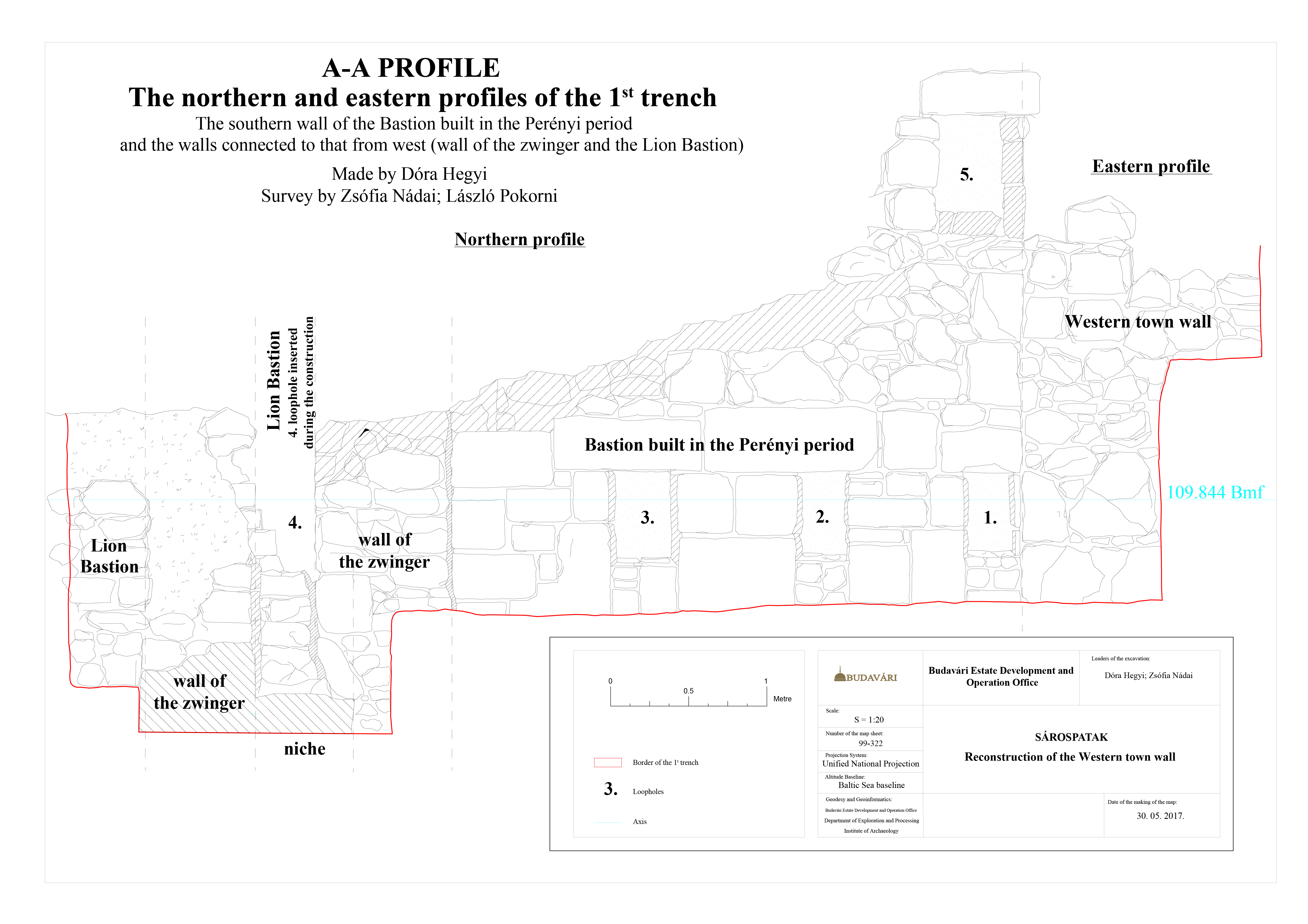
During the 2018 test excavation (Figure 3), one trench (1st trench) was dug at the southern wall of the Lion Bastion's Perényi-period predecessor, precisely at the location where it abutted the western town wall. Here it was possible to investigate the relationship between the southern wall of the later bastion and the earlier building. The south-western corner of the earlier bastion, the southern end of the zwinger wall that was built on the early bastion's western side, and the eastern end of the Lion Bastion's southern wall came to light first. Connections between the walls, at a depth of 2m below present-day floor level, have been interpreted as follows (Figure 4):
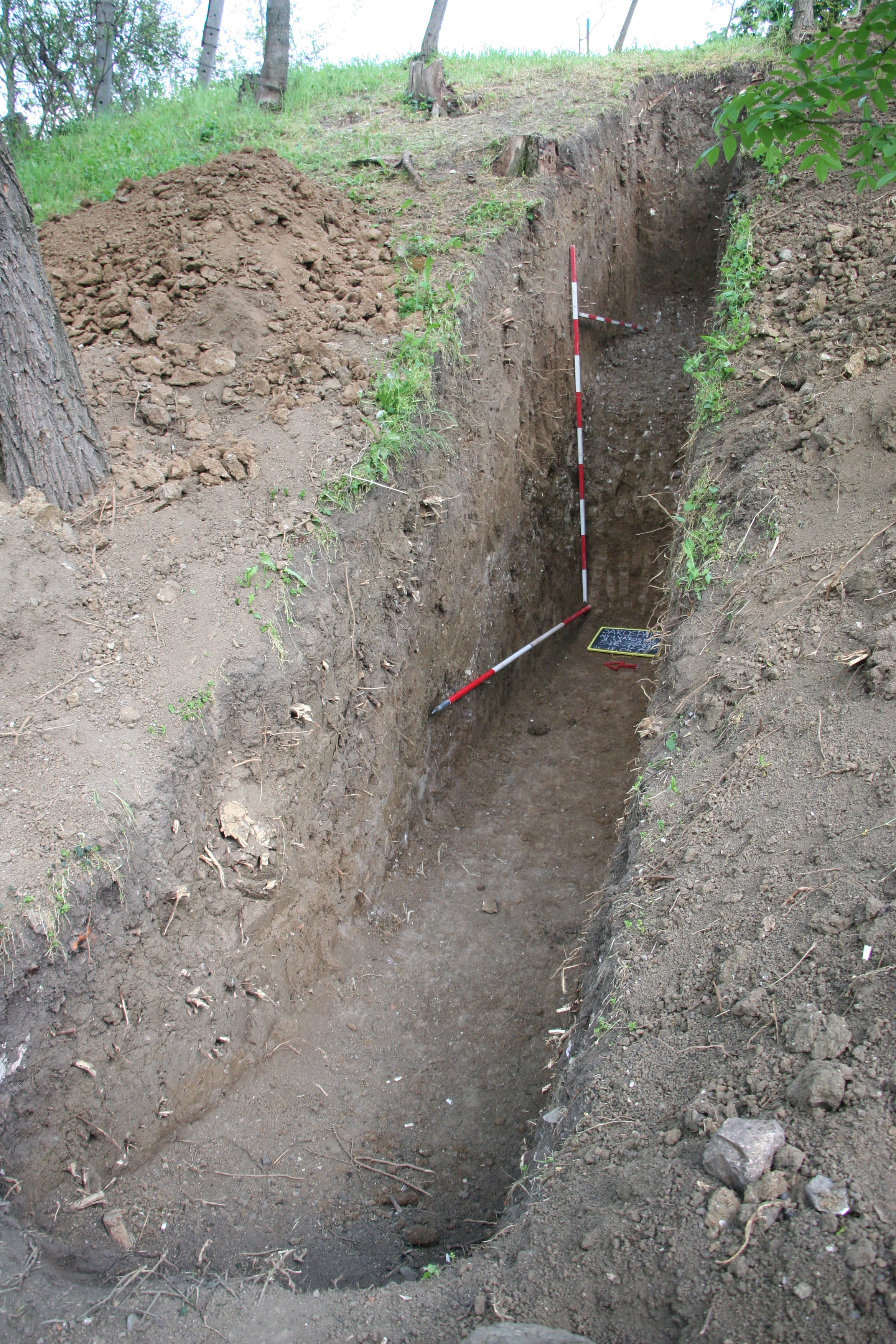
The zwinger wall was investigated further at two locations north of the Lion Bastion (2nd and 4th trenches). The space between the two walls became narrower towards the north (Figure 8). It was observed in both trenches that the external surface of the wall was tiered, but the possibility that this represented deliberate dismantling cannot be ruled out. At a depth of 1.5m there was a homogeneous, brown, clay fill that sloped westwards, in the direction of the once existing moat. The internal surface of the zwinger walls, however, was even, and the excavated wall segments showed that it was almost vertical. In the 2nd (southern) trench it was possible to explore the zwinger to a depth of c.3m; the top 2.5m was a homogeneous, brown clay fill that yielded no artefacts. Underneath this a white, limey, friable layer was present, which in places was mixed with pebbles. This may be interpreted as the historical floor level of the zwinger (Figure 9), but more research is needed to validate this argument, as the southern segments previously excavated by Katalin Dankó failed to resolve this question. Our excavation team cut this layer in a 0.5m-long section in the lee of the external wall in order to find the bottom of the wall foundation. This, however, could not be accomplished: when the friable, marly upper layer was removed, a white rock surface came to light, which was identified as a natural, undisturbed subsoil surface.


Two further exploratory trenches (3rd trench) were dug within the western town wall to explore the structure of the cannon hill, its relationship with the western town wall, and the hypothesised road between the two. Unfortunately, modern disturbances and the poor condition of the wall top hampered our observations. The structure of the cannon hill could partly be explored. The uppermost 15-20cm thick layer of humus yielded a considerable number of artefacts. Beneath this there was a harder, yellowish-brown, clay layer, from which a few objects were recovered. Underneath the latter, a greyish-brown, limey, and very dense layer of soil came to light on top of another brown, very hard, clay layer. These two lowermost layers must belong to the historical structure of the cannon hill; they yielded a few 17th–18th-century pottery fragments (Figure 10).
In conclusion, several segments of the 16th–17th-century zwinger that fortified the northern part of the western town wall were brought to light, and so its line could be reconstructed. Moreover, it was established that the zwinger shown in Angelini's survey north of the Perényi-period bastion, in the middle of the western town wall, in fact continues beyond the bastion in a southern direction. This segment must have been built in a later phase and adjoined the south-western corner of the already existing fortification by a loophole created in alignment with the loopholes on the bastion's lower floor. Later, a 17th-century pentagonal bastion was erected abutting the external wall of the zwinger. Our observations on the cannon hill's structure suggest that no support structure was utilised when the hill was constructed; layers of clay, partly mixed with lime, were deposited and compressed, and the hill proved to be sturdy enough even without any wooden construction to support it.
Development plans concerning the renovation of the Wenckheim mansion in Szabadkígyós also aims to reconstruct the mansion's large park. Our team was involved in the research of this mansion garden, within the framework of the preliminary archaeological documentation. The 19th-century landscape park covers an area of 25.3 hectares, though the project area involves only the mansion's more immediate surroundings.
The research started with the preparation of a study of the area's garden history by Ágnes Bechtold (landscape architect, art historian, NÖF). In connection with this phase, the whole mansion park was declared a historical monument garden in 2017. The position of historic gardens among protected monuments is a complicated issue. Present regulations can provide protection in two ways: the garden may be considered a historic monument in itself, or it may enjoy protection as the environment of a historical monument building. The latter case is more problematic, because only the area registered under the same number as the monument itself is covered, which means that usually only certain parts of such historical gardens are protected (Bechtold 2017).
The first available piece of data on the landed properties in Kígyóspuszta dates from the 1720s, when the village, which had been abandoned in the Ottoman Turkish Wars, came into the possession of the Harruckern family. József Wenckheim acquired it in 1790 as an entailed estate, and it remained in the possession of the Wenckheim family until the end of World War II. József Wenckheim's grandson, József Antal Wenckheim (1780-1852) had the first manor built here between 1808 and 1831. The smaller house, its annexes, and the family crypt are still standing east of the Neo-Renaissance mansion. József Antal Wenckheim modernised the Kígyós manor, which enjoyed a period of economic growth thereafter.
Krisztina Wenckheim (1849-1924), the daughter of József Antal Wenckheim, and her husband Frigyes Wenckheim (1842-1912) had the Neo-Renaissance mansion built according to the designs of architect Miklós Ybl, between 1875 and 1879. Unfortunately, the plans of the mansion were lost during World War II; however, drawings of the garden buildings have been preserved and these also show characteristic elements of Miklós Ybl's designs (Figure 11). Four subsidiary buildings were constructed in the park: a kitchen, a stable, a coach-house, and a gas house, where the gas used in lighting was produced.
The mansion park was created in the 1870s in the deliberately archaic, historical landscape style typical for that period. It was certainly finished by 1883, because it is shown in draft drawings by Gyula Dolesch, made in preparation for cadastral maps (Figure 12). Exotic tree species, such as sweet chestnut, hybrid planes, gingko, pond cypress, and large-leaved linden were planted in the already existing oak woodland. A so-called bosco, a reserve for pheasants, was established in the southern part of the park in 1874.
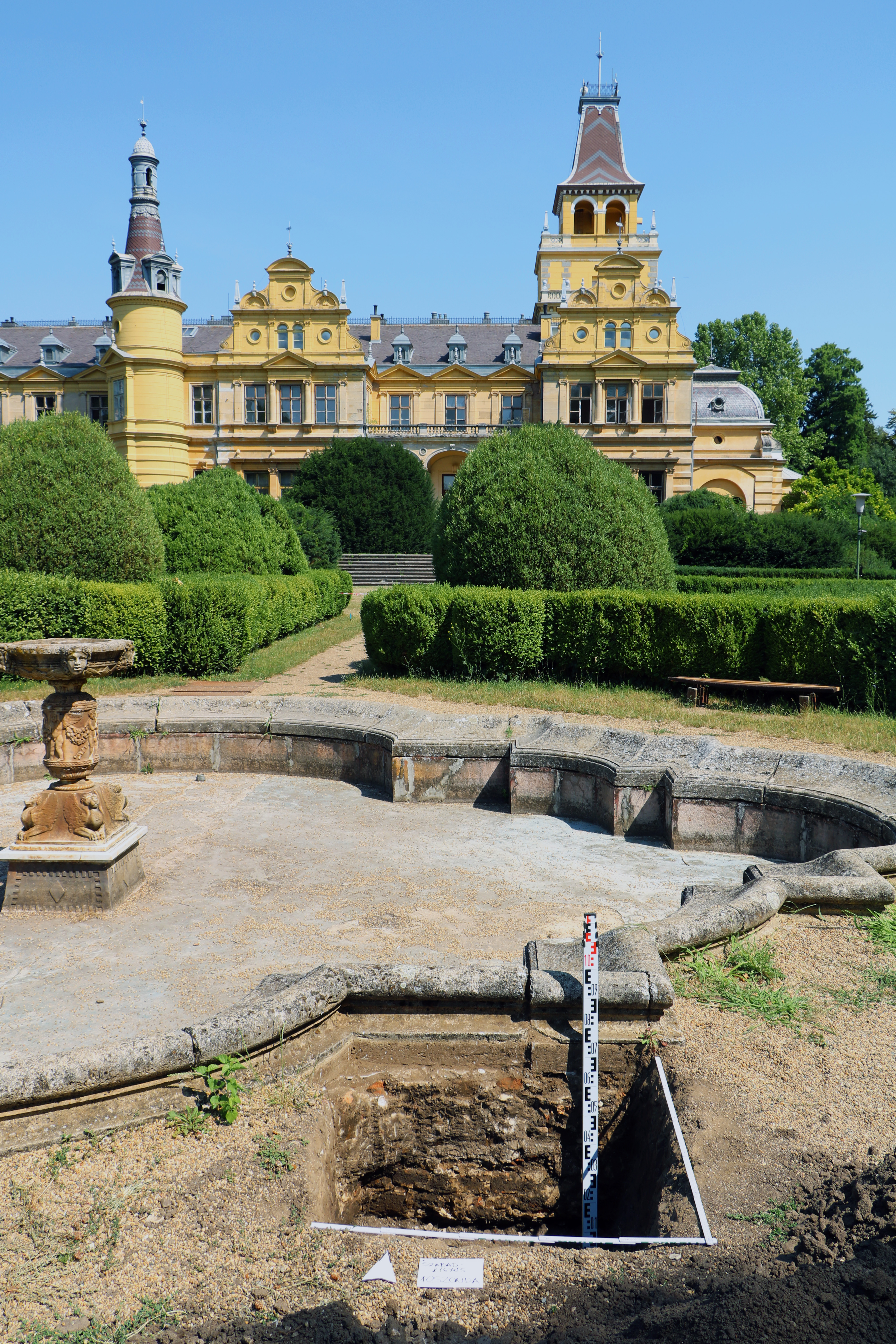
There was one gate on each of the four sides of the park, and the southern and eastern gates had gatehouses as well. An artificial terrace adjoining the southern halls of the mansion was created from the soil piled up around the building. In front of the southern façade, a geometrical ornamental garden, a 'pleasure ground', was built, with a decorative flowerbed featuring a water basin and a fountain in the middle as the main attraction. Archive photographs suggest that the main basin's fountain had been made of quarried rocks instead of the present ornamental one (Figure 13). Another attraction of the park was an artificial lake with a small island, an iron bridge, and a wooden pavilion on a hill. The artificial lakefront is still visible today.
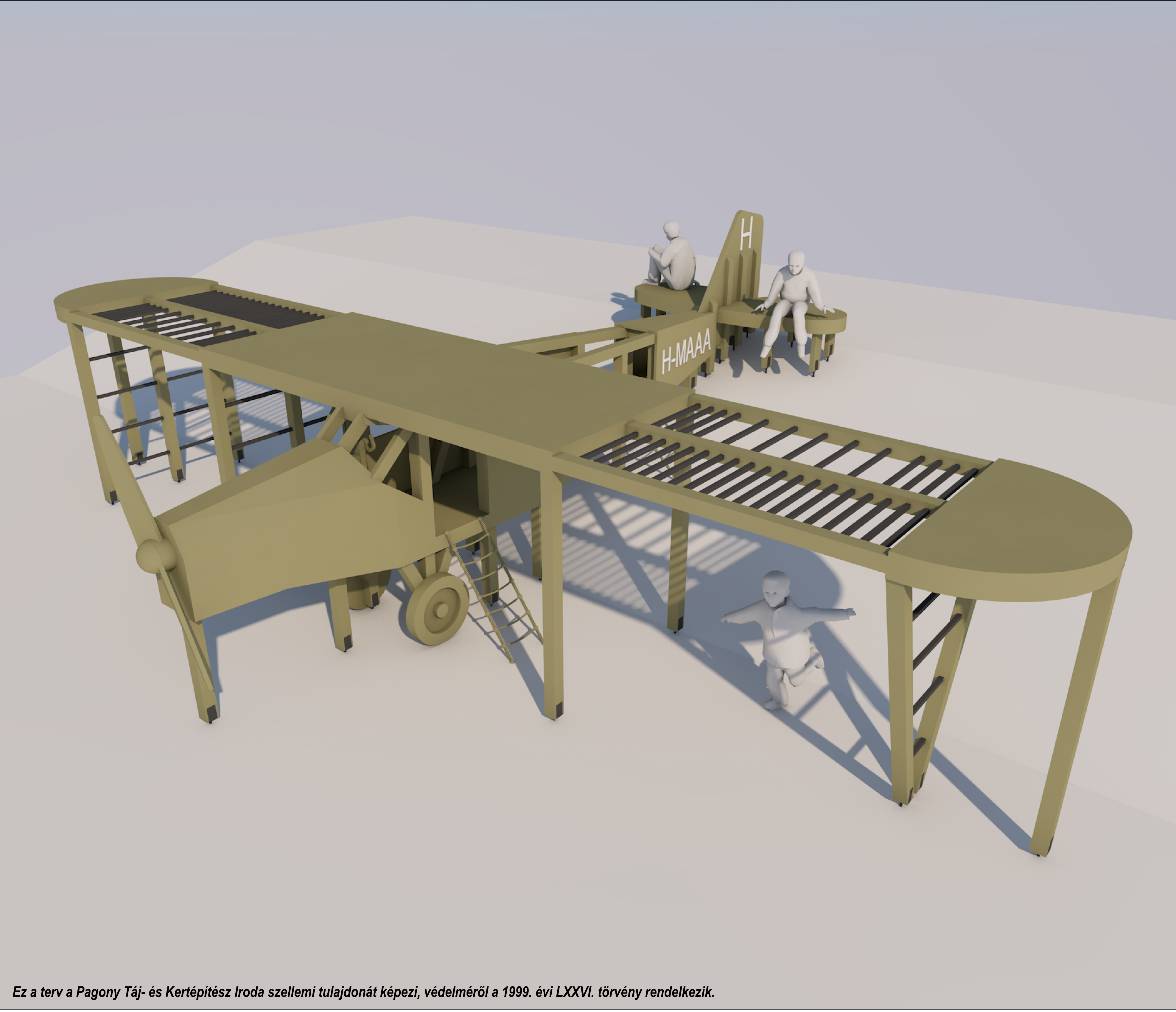
Frigyes and Krisztina Wenckheim had built a swimming pool, a training field, and a doll's house for their seven children. The latter building was visible from the mansion, next to the road that led northwards. This small, bipartite brick construction copied a peasant house with a porch and a thatched roof (Figure 14). Later, a polo field and a tennis court were established as well, and Dénes Szigfrid Wenckheim (1921-1943), the grandson of Frigyes and Krisztina, built a landing strip and a hangar for aircraft.
After World War II the mansion passed into public ownership and the complex housed several agricultural schools. The last school ceased to operate in the mansion in 2011, and since then the building has been managed by the local administration of Szabadkígyós. The mansion belonged to the Szabadkígyós Natural Reserve, and since 1997 it had been part of the Körös-Maros National Park.

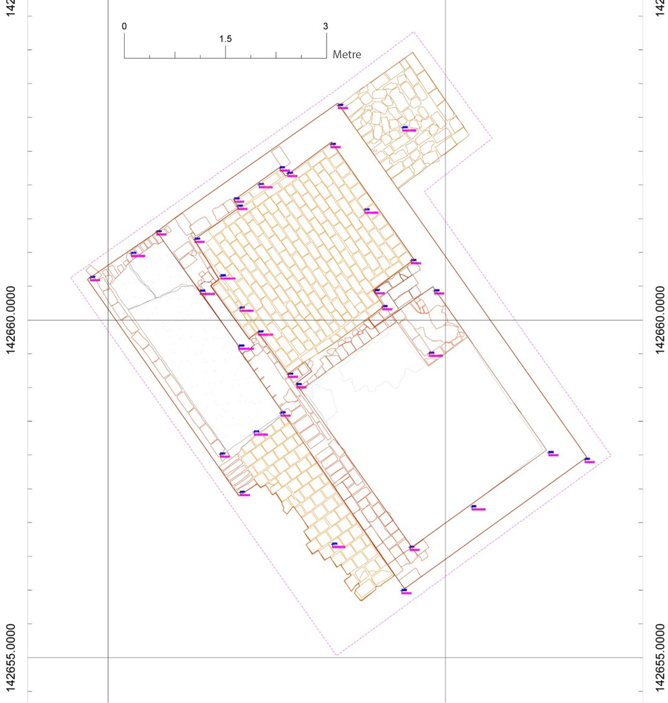
The mansion park was investigated through test trenches in July 2017. Ágnes Bechtold, Zita Németh (landscape architects, NÖF) and András Koppány (building research expert, MÉM-MDK) contributed to this work. These explorations focused on the immediate environment of the mansion and the northern part of the garden, because the first stage of the park's reconstruction targeted this area. This survey primarily aimed to locate sites already known from historical documents (Figure 15), and to examine their built structure and foundations. Built features of the pleasure ground, i.e., the foundation of the central basin, the pathways, and the stone urn foundations around the garden, were brought to light. A flight of stairs leading up to the terrace, the retaining wall around it and the foundation of a smaller stone basin were also explored in the mansion's vicinity (Figure 16).
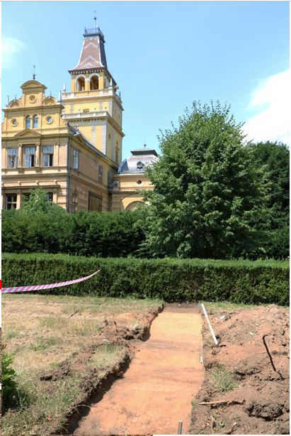
Concerning the garden pathways, we observed that only the main routes leading to the four gates were supported by artificial layers (Figure 17), and their original track could be reconstructed. The remaining pathways, however, were hardly perceptible; in places not even their gravel surface was preserved. These must have been simple, small cart passages with an elevated strip of lawn on each side. The edges of the polo field were damaged by the running track of the later training field, while the tennis court was partly destroyed by the waterworks that were later established here.
The greenhouse in the south-eastern zone of the complex was within the footprint of the chapel and the dining room. It could be accessed from two directions; from the park and from the dining room. The shape followed the chapel's ground plan, and its stone plinths and the stairs are still visible today. The walls and vaulted roof were glass-and-iron structures, as seen in archive photographs (Figure 13). One arched iron element survives on the façade of the chapel, embedded in the plaster. Archaeological explorations were conducted in the greenhouse in 2003, led by András Liska (Liska 2003). The results suggest that the building was heated by a system of brick corridors circulating hot air under the floor; this structure went around the whole room in a rectangular shape, 1.3m under the greenhouse floor. During the 2017 excavations, the whole surface of the greenhouse's stone wall plinth was brought to light, and the building's ground plan was also explored. This makes the reconstruction of the greenhouse possible.
A single 1940s photograph is known of the doll's house, probably built in the early 20th century. The building was demolished in the 1970s. When the rubble was removed, a two-room brick house, orientated from north-west to south-east and equipped with a patio, came to light (Figure 18). The timber-supported patio, covered in bricks, ran along the western wall. The northern room of the building also had a brick floor. A niche window was found in the northern wall of this room. The southern room could be accessed from the other room through a relatively large opening. The original floor of the southern room was not preserved; its window opened to the patio. At the north-eastern end of the dividing wall between the two rooms there was a heating structure with a chimney that projected into both rooms. After 1945, the part of the patio that was parallel to the northern room was transformed into a narrow hallway and its floor was covered in cement. A small, rectangular storage building was also added to the northern corner of the doll's house (Figure 19).

Such garden houses, where people could rest and play, were typical for 19th- and 20th-century gardens. Built in a deliberately archaic style, such buildings were usually ornamented with folklore elements. In the royal gardens of Buda, a peasant house was built for Queen Elisabeth in 1898 in place of the 'Dutch peasant house'; this house was embellished with Hungarian folklore motifs. This building, also called 'the Hungarian house' (although its style is more typical of houses in Switzerland) was built according to the plans of Alajos Hauszmann. The playhouse built for the children of the count of Nádasdladány also belongs to this type: it was a small, rectangular, two-room building with a thatched roof and a patio around it. This was known as the 'school of Hungarian farmer women', which later, when the children grew up, was used as an ornamental garden house.
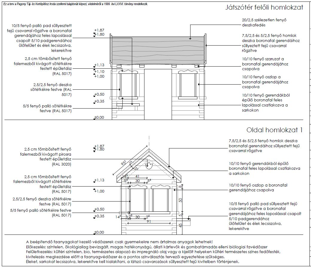
The plans for the park's reconstruction were developed by Ágnes Herczeg (Pagony Tájépítész Iroda, 'Pagony' Landscape Building Office). The park will be renovated in three phases; first the mansion's immediate environment will be reconstructed. The garden pathways will be rebuilt according to the hierarchy suggested by research, partly as gravel-walks and partly as simple dirt roads. Substructures of the built heritage, such as retaining walls, flights of stairs, basins, and garden fountains, will be re-made as copies of the originals. In addition to the reconstructed features there will be a playground in the north-eastern part of the garden, with special toys referencing the history of the Wenckheim family. A timber house will be erected next to the original foundations of the doll's house. This will not copy the original, but rather give an idea about it. Another interesting element of the planned playground is a jungle-gym in the shape of an aircraft, to remind visitors that Dénes Szigfrid Wenckheim was a passionate pilot (Figures 20 and 21).
Through these two examples of minor research Sárospatak and Szabadkígyós, we could see that they were essential for the authentic reconstruction plan of the sites. Only limited investigations can be taken on monumental sites in advance of the planning process, and in some cases further excavations will be needed.
Internet Archaeology is an open access journal based in the Department of Archaeology, University of York. Except where otherwise noted, content from this work may be used under the terms of the Creative Commons Attribution 3.0 (CC BY) Unported licence, which permits unrestricted use, distribution, and reproduction in any medium, provided that attribution to the author(s), the title of the work, the Internet Archaeology journal and the relevant URL/DOI are given.
Terms and Conditions | Legal Statements | Privacy Policy | Cookies Policy | Citing Internet Archaeology
Internet Archaeology content is preserved for the long term with the Archaeology Data Service (ROR). Help sustain and support open access publication by donating to our Open Access Archaeology Fund.
 Home
Home