Cite this as: Zirne, S. 2020 The Practice of Preserving and Presenting Archaeological Sites in Latvia, Internet Archaeology 54. https://doi.org/10.11141/ia.54.8
The Republic of Latvia is one of those European countries that was established after World War I. Thus, the formation of the national cultural monument protection system only began in the 1920s, when the political and economic situation in the country was stabilised. Until then, the heritage protection policy in the country was dependent on the overall geopolitical situation in the Baltic region.
The first Latvian Law on Protection of Monuments was passed in 1923. The main purpose of the legislation was to protect movable and immovable monuments with archaeological, ethnological, historical or artistic value, whose preservation was in the interests of the Latvian state and people (Section 1). In accordance with the legislation, a new institution was established; the Board of Monuments. This marked the beginning of the national cultural heritage management system in Latvia. The Board of Monuments was responsible for the whole of Latvia's cultural heritage, but the focus of its activities was the identification, study and protection of archaeological sites.
For example, in 1927 the Board organised and carried out one of the first large-scale archaeological excavations in the fortified Iron Age settlement of Rauna Tanīsa hill-fort, located in the central part of Latvia. The excavations were visited by the President of Latvia, Gustavs Zemgals, and the Minister for Education, Jānis Pliekšāns. The course of excavations was filmed. A documentary film called 'The Ancestral Hill-fort' was later screened at the Splendid Palace cinema in Riga. An introductory lecture on Latvian hill-forts and their significance was given before film screening. Thereby the importance of archaeological heritage was raised at national level.
Until the Soviet occupation in 1940, about 1000 archaeological sites were identified and included in the State's list of protected cultural monuments. Subsequent lists of the archaeological monuments of Latvia are mainly based on the materials collected by the Board of Monuments until the autumn of 1944, when the Board was abolished.
Systematic state management of cultural heritage was interrupted by World War II and the Soviet occupation. In the post-war period, heritage protection was the responsibility of the Ministry of Culture and its special institutions. The character of listed monuments was reconsidered on the basis of class-conflict paradigms, but historical and architectural monuments were most affected. Several lists of cultural monuments were compiled during this time. Archaeological monuments were included in all lists, which over time tended to increase their total number. Thus, among the cultural monuments listed in 1952 there were 171 archaeological monuments, but by 1984 the total number had increased to 1504 (Šnē 1999, 167). To some extent, economic activities prompted the discovery of new archaeological sites. For example, in the rural areas of Latvia, between 1950 and 1980, intensive and large-scale land improvements took place. During these works, 27 Stone Age settlements and 41 Bronze Age and Iron Age settlements were discovered in the area of the wetlands of Lake Lubāns, located in the eastern part of Latvia.
A single institution responsible for cultural heritage was established in 1988. That was the time when political changes began in the Soviet Union. In 1992, after the restoration of Latvia's national independence, it was reformed into the State Inspection for Heritage Protection, renamed in 2018 as the National Heritage Board of Latvia. The Law on Protection of Cultural Monuments was also adopted in 1992, and amended in 2018.
Along with other responsibilities, the National Heritage Board gathers information, studies cultural heritage, carries out national record keeping of cultural monuments and issues instructions to owners on the utilisation and preservation of their cultural monuments.
There are 2524 archaeological monuments in Latvia, located on state, municipal or private land. The owner or land user is responsible for maintenance and use of archaeological monuments. According to the Law on Protection of Cultural Monuments, modification of a cultural monument will only be permitted if it is the best way to preserve the monument, or if the cultural and historical value of the monument does not decrease as a result of the modification.
The owners of cultural monuments may receive public financial support. Funding sources, such as the State cultural monument research, rescue and restoration programme of the Ministry of Culture, State non-profit organisation Culture Capital Foundation (CCF), are available for owners and researchers. Among the strategic directions set by the CCF are the training of specialists in cultural heritage research, as well as preservation, practice and support of theoretical and research works for public use or reference purposes. These mechanisms support various projects implemented by public organisations, municipalities and regional authorities.
The specific values of the sites are defined in the documentation prepared for listing. They differ according to the typological group of the cultural monument. There is no doubt about the scientific, cultural and educational significance of archaeological monuments. However, their set of values is much often wider, as they also include historic and symbolic importance, as well as more intangible aspects.
Most archaeological monuments are not visible above the ground, and their main properties to be physically preserved are the topography, archaeological context, stratigraphy, ancient burials and other historical elements. In order to ensure their preservation, activities that change the surface of the ground in such places are not permitted. The preservation of archaeological sites is sometimes threatened by the attitude of landowners, especially when priority is given to the economic benefit of land management, such as forestry, various types of construction and agricultural activities.
Certain types of archaeological monuments, such as hill-forts, medieval castles, ancient cult sites and others, are distinguished by their external form. The outer form of hill-forts and their fortification elements, such as terraces, ramparts and ditches, has become an outstanding landscape value. Therefore, at the hill-forts, any buildings or historical reconstructions are not permitted, even if they are based on the archaeological evidence. Reconstruction of buildings is usually carried out on a site adjoining the hill-fort. Exceptions are allowed in places where a long-standing cultural tradition has developed. Hill-forts and medieval castle sites were often popular places for local celebrations, and during the 19th and 20th centuries, open-air stages were built at some Latvian hill-forts and castles, sometimes without any prior archaeological investigation. If such places have retained their cultural significance for local people, it is permissible to reconstruct the open-air stages, without expanding them. Also, some improvements for visitors such as adding stairs or benches, are allowed but they should not become the dominant element.
After several unsuccessful solutions for the preservation of medieval castle ruins, the Scientific Council of the National Heritage Board issued guidelines in 2010 for the preservation, restoration and use of medieval castle ruins. The guidelines were developed on the basis of the experience of the conservation of Bauska's medieval castle ruins.
Bauska Castle complex is located in the southern part of Latvia, on the land strip between the Rivers Mūsa and Mēmele. The castle complex consists of two interconnected parts that were built in different periods (Figure 1). The oldest part is a medieval fortress built in the middle of the 15th century by the German Order. The other part is a ducal palace, constructed at the end of the 16th century in the Mannerist style in place of the former castle front. The castle was fortified with protective walls, bastions and ramparts. In 1706, during the Great Northern war, the fortification systems of the castle were blown up. After the war, the castle no longer had a function and gradually decayed into ruins. For centuries, the roofless walls of the castle were exposed to precipitation that accelerated erosion processes and deterioration of the walls.
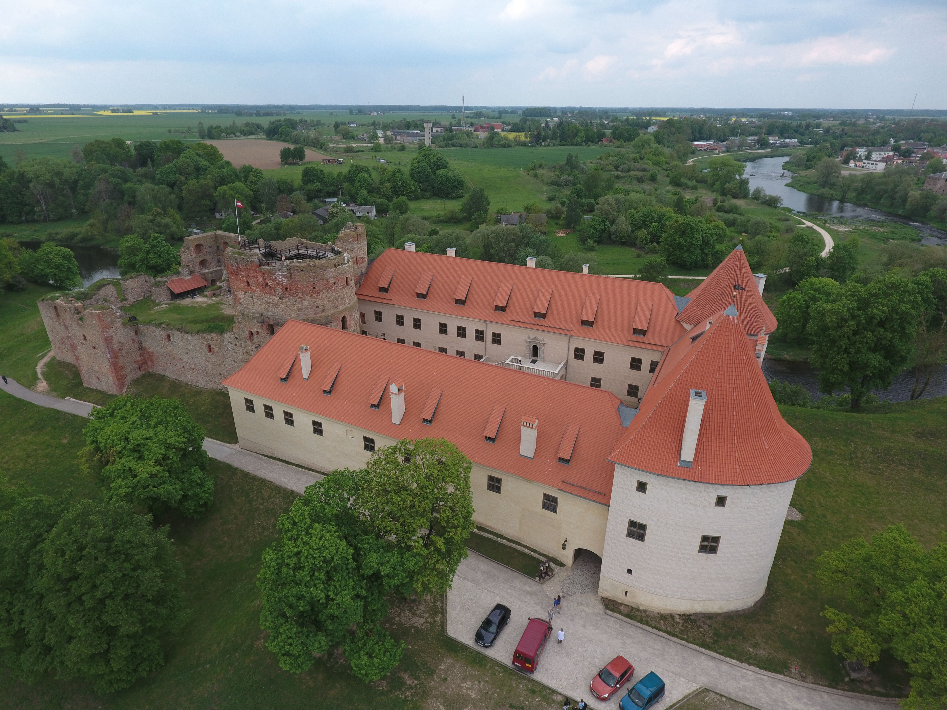
The investigation and gradual restoration of the castle's newest part began in 1973. The main task of this restoration was to preserve all the existing authentic fragments of the building. The project for the preservation of the medieval fortress ruins was developed by the Bauska Castle Museum, which had been established in 1990. In 1999, Czech studio, Girsa a.t., in co-operation with the museum and the Czech conservator, Miloš Gavenda, developed the concept of the preservation of castle ruins and the project of conservation technologies.
The Bauska Medieval Castle conservation concept was to preserve in full the landscape and historical value of the ruins, as well as to stop the erosion processes and ensure stability of the stone walls. The aim was to alter the original structure as little as possible and still make the ruins safe for visitors. The quality of conservation works was ensured by studies of historical crafts and materials, and their application at the site (Girsa 2002, 20-22). Bauska mortar technologies were used in the stabilisation process of Bauska Castle. The upper part of the restored stone walls was covered with peat and a clay layer, which together provide good protection against the effects of precipitation.
Maintaining an archaeological monument means not only taking care of its archaeological features, but also respecting the surrounding landscape. Despite the changes that have taken place over the centuries, archaeological sites have become an integral part of the landscape.
One of the territories in Latvia where significant landscape changes have taken place during the last century is the Daugava River valley. The Daugava originates in the Valdai Hills in Russia, from where it flows through Russia, Belarus and Latvia, finally reaching the Baltic Sea in the Gulf of Riga. Historically, the Daugava River was one of the most important Eastern European trade routes, which promoted the development of local cultures along the river. During the Late Iron Age (9th-12th centuries CE), there was an intercultural environment along the Lower Daugava River, influenced also by the arrival of the first Christian missionaries.
Today, the Daugava River valley area is known for its multiplicity of archaeological sites, ranging from Stone Age settlements to medieval castle sites. During the last century, three hydroelectric power plants were built in the lower reaches of the Daugava River. The reservoirs of these power plants cover part of the Daugava ancient valley. As a result, several archaeological sites and important natural places such as dolomite cliffs and rapids, are completely or partly under water. Construction works on reservoirs for power stations caused changes to the local water levels, and erosion of riverbanks began. This endangers archaeological sites near the reservoirs. To prevent this, various technical solutions are being sought and implemented.
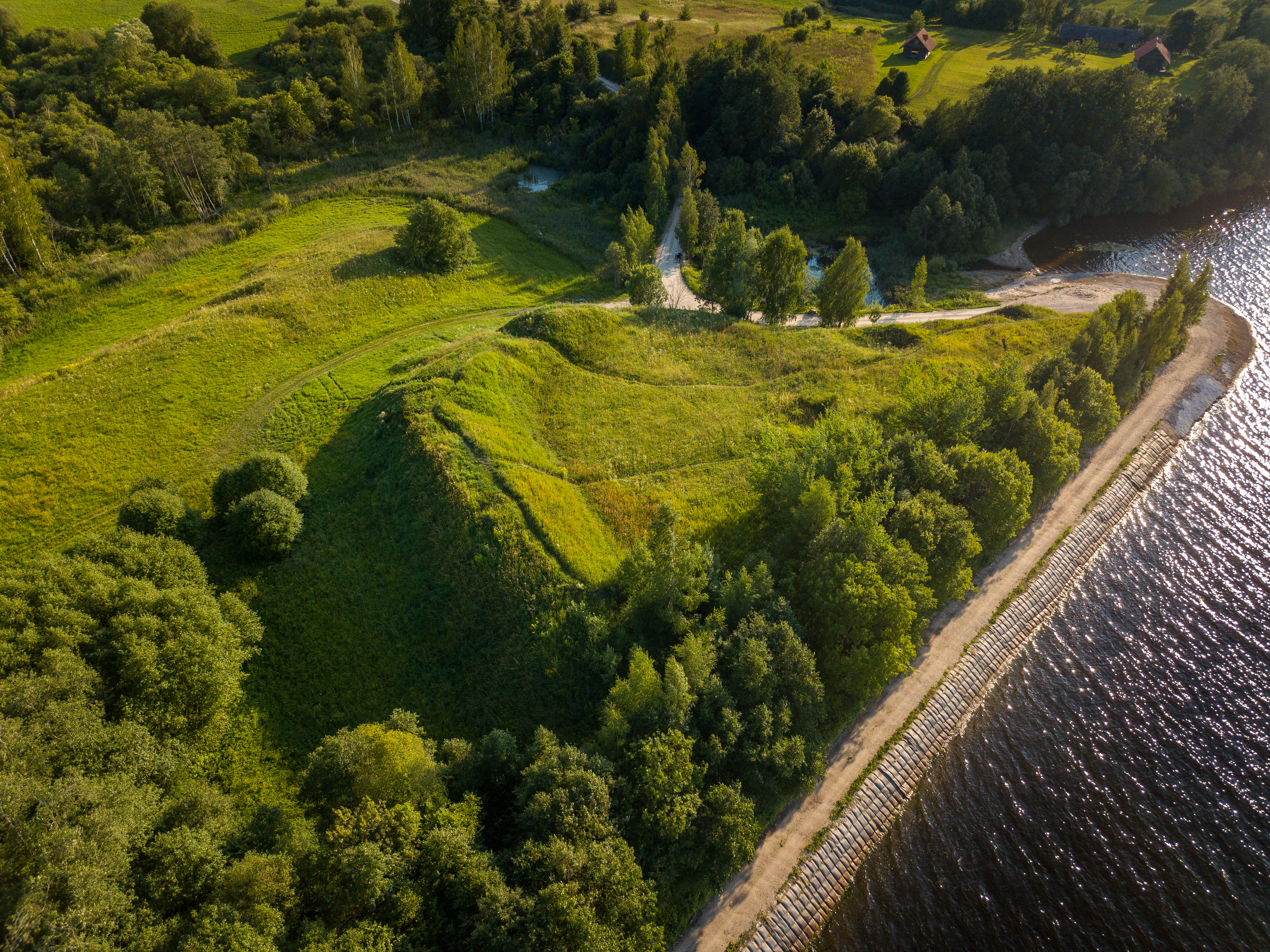
One example of such a situation is the Daugmale archaeological complex, comprising a hill-fort, settlement and burial ground. Daugmale was one of the most important ancient craft and trade centres along the Daugava River during the Middle and Late Iron Age (5th-12th centuries CE), and archaeological excavations show that the hill-fort was first inhabited in the second millennium BCE.
The archaeological complex at Daugmale is located on the left bank of the Daugava River. After the Riga Hydroelectric Power Plant became operational in 1974, Daugmale hill-fort remained close to the shores of the reservoir. In order to prevent the erosion of the hill-fort slope, a road for dam construction/repair has been built along the foot of the hill-fort. In this way, the foundations of the hill-fort have been shored up. At the same time, the road is used to strengthen the shoreline of the reservoir (Figure 2).
Koknese Castle (Figure 3) is a medieval monument that was partly flooded in 1965. The stone castle of Koknese was built in 1209 on a site previously occupied by a hill-fort destroyed by Crusaders. The medieval castle was constructed on a 30m high hill near the confluence of the Perse and Daugava rivers. From 1397 to 1566, Koknese served as a residence of the archbishops of Riga. Koknese castle was separated from a forecastle by a moat with a bridge over it. To the east of the castle was a medieval town. During the Great Northern War, the castle was destroyed and left unrestored.
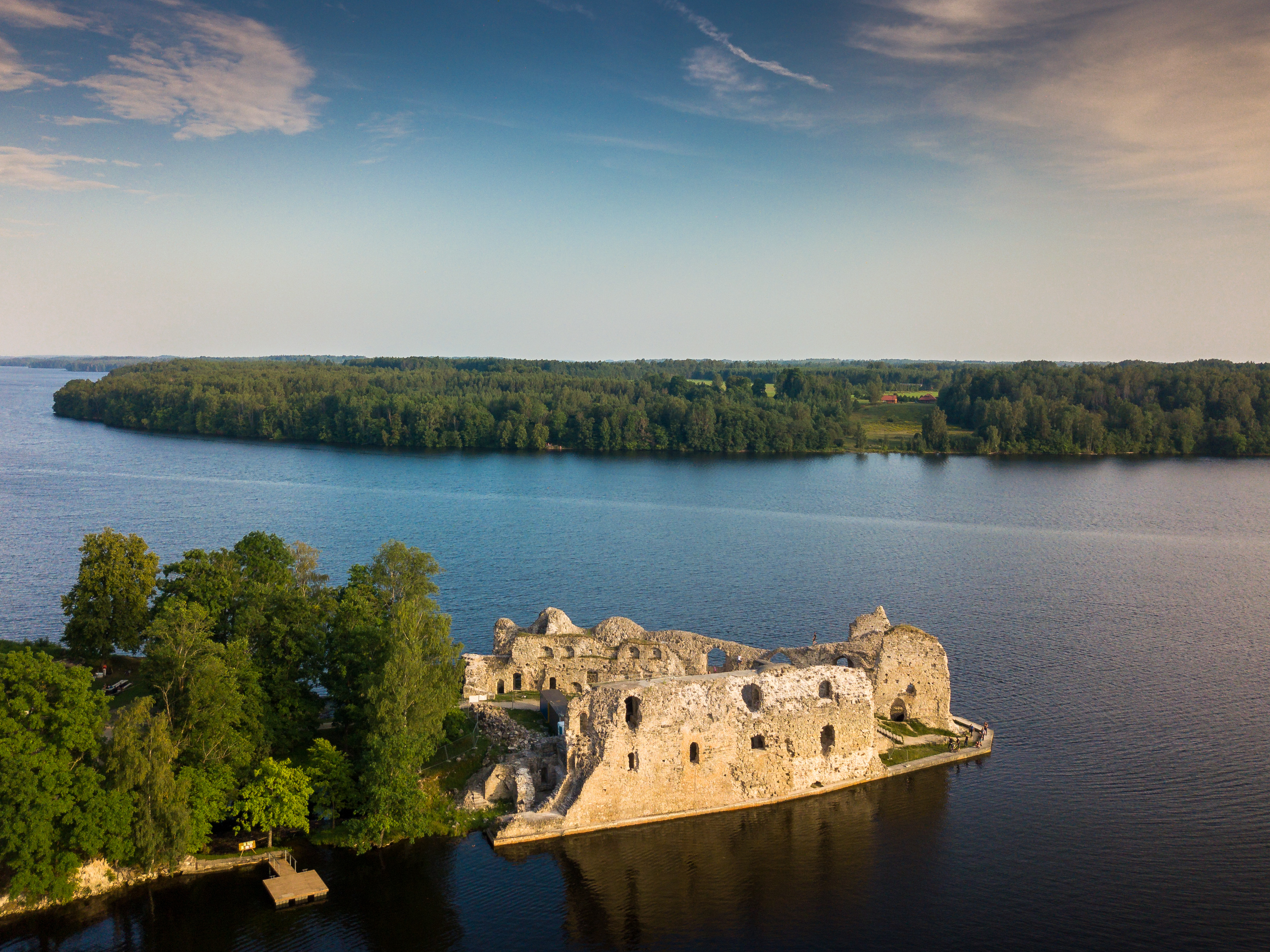
After the construction of the hydroelectric power plant reservoir, water levels reached the foundations of the castle ruins and started to undermine them. Since the 1990s, the walls and foundations of the castle have been reinforced and conserved. The ruins are reinforced with concrete structures below the water, which was achieved during periodic lowering of the reservoir levels. At the same time, systematic conservation of the castle ruins above the water level have been carried out. Today, Koknese castle is a popular tourist destination and has become one of the symbols of values lost during the Soviet occupation.
There are several territories in Latvia that are distinguished by the diversity of their natural landscapes and cultural heritage value. They have a special protection status. The maintenance, preservation and use of such areas are subject to special regulations. In these territories, archaeological sites, cultural monuments of different periods and landscapes are protected in their mutual relationship as a unified complex. The ancient Dviete River Valley, the Abava River Valley and the Gauja National Park are just some of these territories in different regions of Latvia.
The ancient Dviete River valley (Figure 4) is located in the eastern part of Latvia. The landscape of the Dviete River valley has been influenced by human activity. The first people arrived here about eleven thousand years ago, soon after the glaciers retreated. A small reindeer-antler harpoon, found on the banks of the Dviete River, provides evidence of human presence here. More intensive settlement of the Dviete Valley is thought to have taken place during the Mesolithic and Neolithic. In the late 1930s, while the riverbed was being straightened, artefacts characteristic of these periods were found (bone, flint artefacts and ceramics) on the shores of the Dviete.
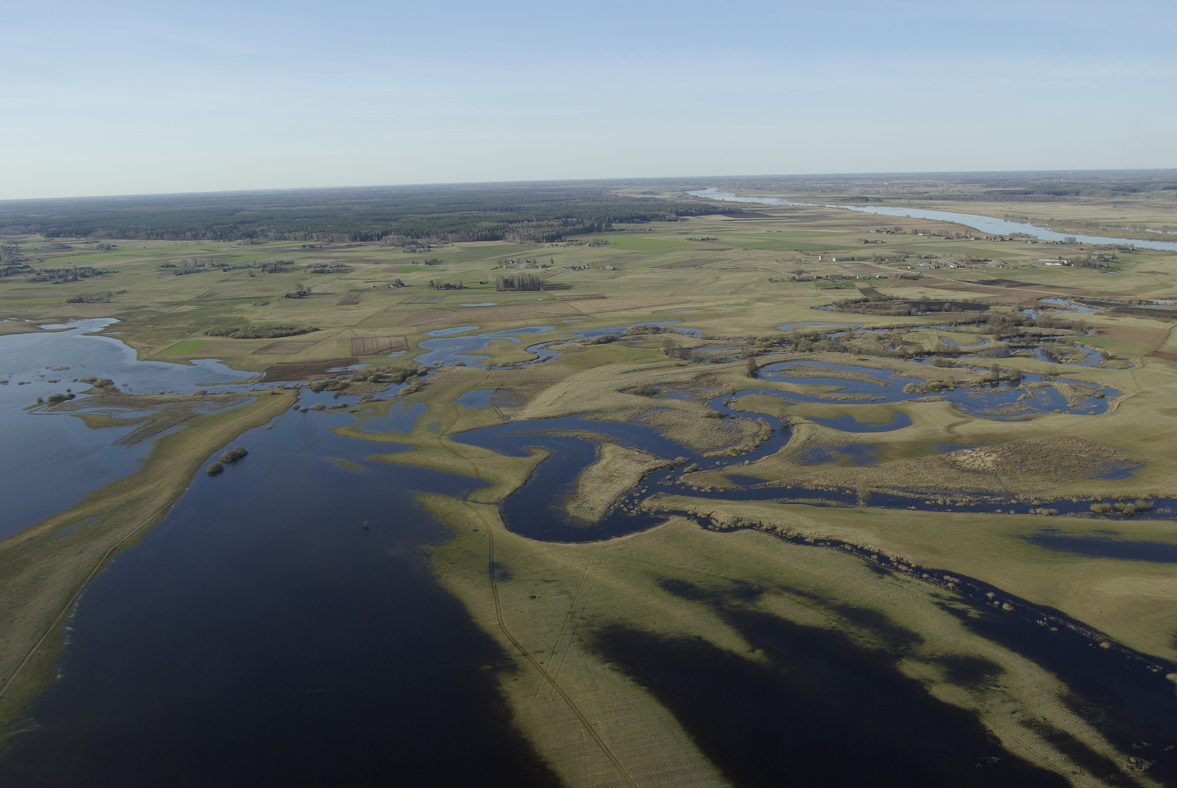
Today in the Dviete River valley, a range of archaeological monuments exist that characterise the historical development of this area over a period of thousands of years; the settlement sites from the Stone Age and the Middle Ages, and Iron Age burial grounds. Stone Age settlements are found along the banks of the Dviete River, as well as on the shores of the nearby Skuķu (Grīvas) Lake, where two settlements were discovered in 2002. The cultural layer of the settlements is well preserved because the meadows where they are located are damp and flood regularly. The water level in the lower reaches of the Dviete in springtime can rise above low-water period levels by more than 6m, so settlement areas have only been used to harvest hay and have never been ploughed. These settlements are closely linked with Skuķu (Grīvas) Lake, where other possible settlement sites have been identified.
In the Dviete River valley, a nature park, Dviete Water-Meadows, was established in 2004, covering an area of 4989 hectares. The park has an information centre that provides details about the natural and historical values of the Dviete River valley. Thanks to staff activities, new archaeological sites were discovered and explored here. The Dviete Valley illustrates how nature protection policy can also ensure the identification, research and protection of archaeological sites.
In the western part of Latvia is the valley of the Abava River (Figure 5), formed as a result of melting ice waters during the Ice Age. The Abava River valley comprises a rich landscape of cultural-historical and natural heritage, which has formed from the 2nd millennium BCE to present. There are more than 30 different archaeological monuments located here. In 1996, following its inclusion on the World Monuments Fund's Watch List of endangered heritage sites, Latvia designated the Abava Valley as a specially protected cultural and historical territory. In order to maintain and develop this territory, the Regulations of the specially protected cultural and historical area 'Abava River Valley' were adopted in 1996. According to the Regulations, in this territory construction of any new structure that degrades the environment is prohibited, neither can existing structures that are environmentally degrading be enlarged. It is also forbidden to destroy cultural and historical monuments in the valley, or to transform or modify the historical terrain.

Gauja National Park, founded in 1973, is the largest national park in Latvia. It covers an area of over 90,000 hectares in the central part of Latvia, along the Gauja River. According to the Law on Specially Protected Nature Territories (adopted in 1997), the main goals of national parks are nature protection, preservation of cultural and historical heritage, scientific research, and organisation of education and recreation, as long as they do not conflict with the protection of nature and the cultural environment. In the territory of the Gauja National Park there are more than 500 cultural monuments, including such archaeologically important places as Turaida, Cēsis and Āraiši.
Turaida Museum Reserve was established in 1988 and occupies an area of 42 hectares in the territory of the Gauja National Park. In 2013, the Regulations of the specially protected cultural monument Turaida Museum Reserve came into force. According to the Regulations, the mission of Turaida Museum Reserve is to build a harmonious society through natural, cultural and historical values exemplified in the Turaida Region.
There are numerous objects of heritage value related to the period from the 11th to the 20th centuries within Turaida Museum Reserve. The most impressive archaeological monument is Turaida medieval castle (Figure 6), built at the beginning of the 13th century. From the 13th century until the second half of the 16th century, Turaida was of great economic and military importance to the Archbishop of Rīga. The castle experienced a gradual decline from the 17th century, after losing its military significance and becoming a private property. During the 18th to 20th centuries, several medieval defensive structures of the castle were re-purposed to serve the needs of the local economy.
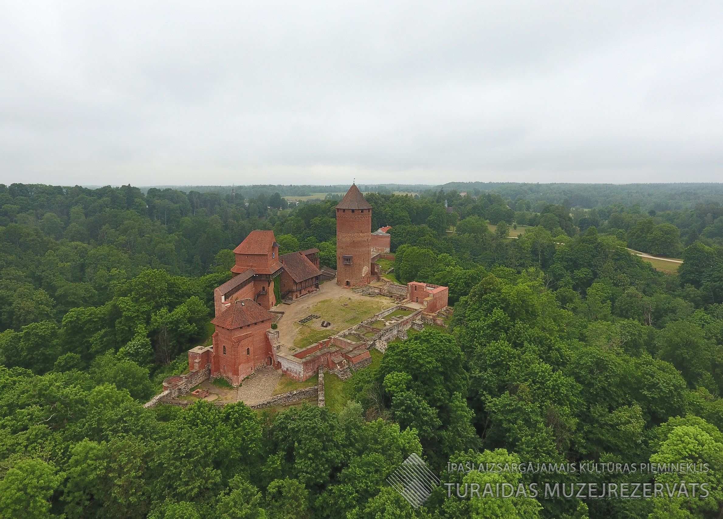
From 1974 to 1999, systematic and extensive archaeological excavations were carried out, together with the architectonic investigation of the castle, followed by restoration, reconstruction and conservation of the buildings. The works were led by archaeologist, Jānis Graudonis (1913-2005), and architect, Gunārs Jansons (1928-2013). The tower height, roof form and buildings had been designed by historical analogues. The structures of the castle revealed in the archaeological excavations were restored, and exhibitions were installed in those buildings. Today, the complex of Turaida castle is one of the most impressive cultural landmarks in Latvia.
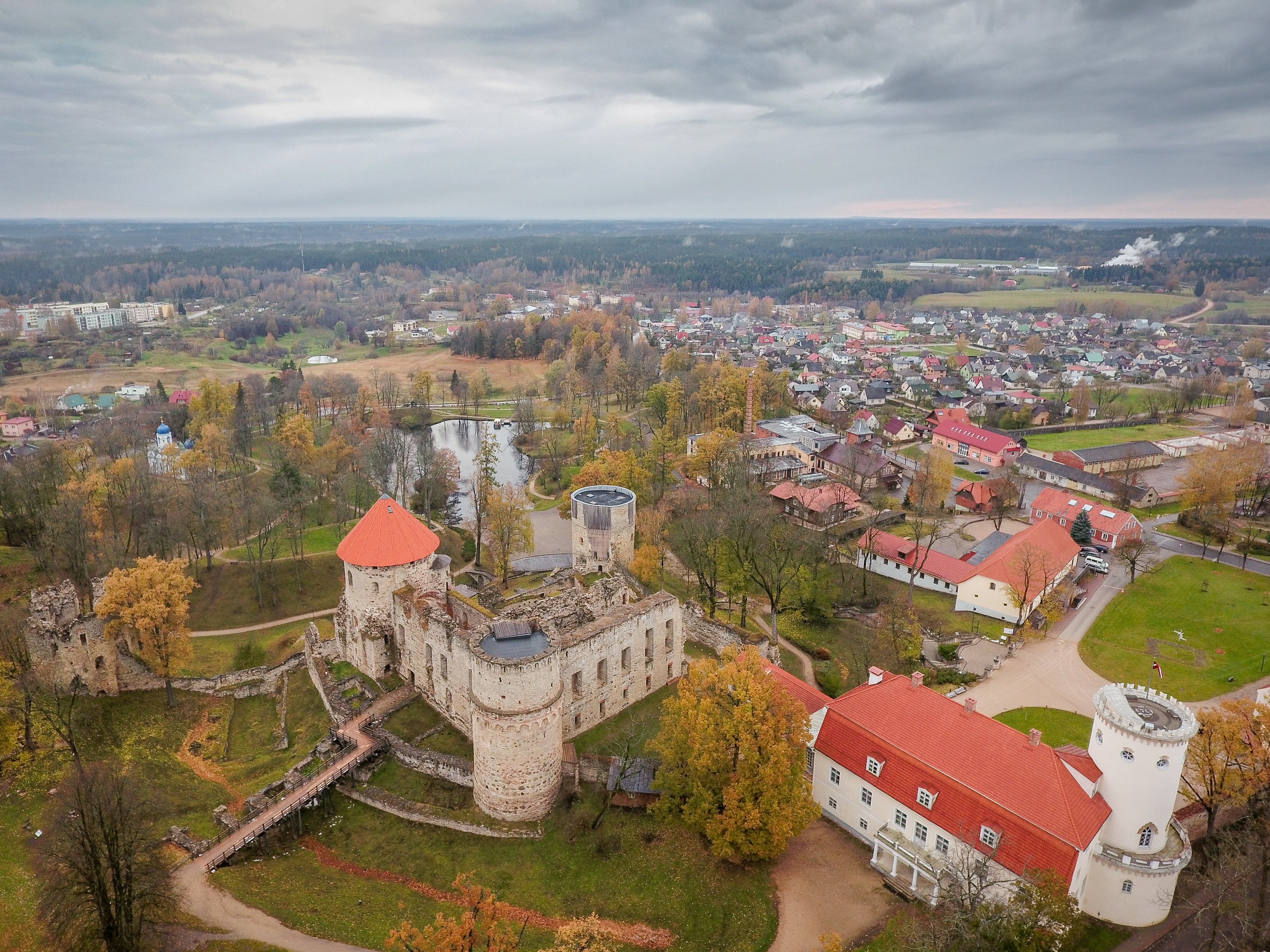
Cēsis is a small town in the territory of Gauja National park. The Cēsis Castle complex, which consists of various historical sites, is located in the historical core of the town (Figure 7). In the centre of the complex is the archaeologically investigated and partly reconstructed medieval castle, built at the beginning of the 13th century. Nearby is the manor complex of the castle, dominated by the manor building, which houses the municipality's agency, Cēsis Culture and Tourism Centre, and the Cēsis History and Art Museum, a section of the agency. Riekstu Kalns hill-fort is located in the park of the 18th- and 19th-century manor. The hill-fort was inhabited by the local Vendi tribe before the stone castle was built. The complex of ancient sites at Cēsis has a high cultural-historical value that reflects the continuity of the town's historical development.
Not far from the Cēsis, in the territory of Gauja National Park, there is another complex of archaeological sites at Āraiši Museum Park. The archaeological museum park consists of a 9th-11th century lake fortress and its reconstruction, ruins of a 14th to 17th-century castle, and Meitu Island, on which Stone and Bronze Age dwellings were built as a result of experimental archaeology. In total, the museum park covers an area of 12 hectares on the shores of Āraiši Lake.
The reconstruction of Āraiši Lake fortress (Figure 8) is an example of experimental archaeology in Latvia, carried out from 1981 to 1995, and continues to the present day. Lake fortresses are a particular form of ancient settlement. Remains of such lake villages have been found at several other lakes in northern Latvia and southern Estonia. Āraiši Lake fortress is located on an island situated 50m from the shore. The island was linked to the lake shore by a rocky shoal allowing access. The lake settlement area is approximately 2500m€.

The first archaeological excavations here were carried out in 1876-77, but the most extensive research was carried out by the archaeologist Jānis Apals (1930-2011) between 1965 and 1969, and subsequently from 1975 to 1979. Until the excavations of the 20th century, the site was completely under water, which ensured the preservation of wooden structures and organic materials (Apals 2002, 24).
During the archaeological excavations five chronologically successive and uninterrupted stages of building processes were discovered. In each phase, the settlement had 16 dwelling houses. The buildings were placed on a substructure of piles that were covered with a circular wooden floor, and surrounded by defensive structures. In the submerged, waterlogged conditions, the lower parts of the buildings had been preserved to a height of 4-5 logs, and elements from the demolished upper parts were found in the cultural layer (Apals 2011, 219).
The project to reconstruct the village fortress was initiated by Jānis Apals. The earliest building phase, dating from the 9th century, was chosen for reconstruction since this was the best preserved. The lower sections of the buildings were re-created as copies of the recovered originals, while the upper parts were reconstructed on the basis of structural elements from these buildings found in the archaeological layers. Reconstruction was carried out using replicas of ancient tools and methods to give it maximum authenticity. The reconstructions of 16 buildings and the foundation of the outer passageway of the lake fortress were completed in 2010. The buildings were built of timber corresponding to those of the original structure - round timbers of spruce, with some pine. Thus, the reconstructed Āraiši lake fortress exhibits a high degree of historical accuracy. The buildings of the lake fortress have been repaired every 5 to 12 years (Apals 2011, 219).
Under the leadership of Janis Apals, the Āraiši complex was developed as the first open-air archaeology museum in the Baltic. It stands out because of its unique archaeological finds, the reconstruction in the original environment, and the characteristic historical-cultural landscapes of the central part of Latvia. Āraiši archaeological museum park is a member of EXARC, the organisation of open-air archaeological museums in Europe.
The town of Grobiṇa is situated in the eastern part of Latvia. Here is an archaeological ensemble that comprises several contemporary archaeological monuments: Grobiṇa hill-fort (Skābarža hill) and the ancient town, two burial mound sites and two flat grave burial sites, all located in Grobiṇa and its surroundings. These monuments mostly date back to the 7th-9th centuries and they are related to an impressive Scandinavian settlement, which was referred to in the 9th-century written sources under the name of Seeburg. Near the hill-fort are the ruins of a 13th-17th century castle (Figure 9).
In the early centuries AD, Grobiṇa and its surroundings were associated with the Curonians, one of the Baltic ethno-cultural groups. With the arrival of Scandinavian seafarers in the 7th century two different cultures and ethno-linguistic groups co-existed in Grobiṇa, which lasted until the 9th century, when a Scandinavian presence in the region can no longer be identified.
Since 2017, the Grobiṇa archaeological ensemble has been on Latvia's Tentative World Heritage List. This has considerably changed the attitude of the local community towards their archaeological heritage. Prior to the UNESCO nomination, the archaeological monuments of Grobiṇa did not attract significant local interest.
Today, major cultural activities are inspired specifically by the archaeological sites and related historical events. Most of the local people now know about the Vikings and how they lived. Reconstructions of historical events and other activities, even on an international level, have become a tradition and have attracted the attention of tourists. It seems that the town has found its identity.
Archaeological sites have to survive; they are important for people. In the past few years the interest in them has been increasing, especially alongside the growing interest in historical reconstructions. Various historical reconstruction and re-enactment clubs and societies are studying archaeological materials to create suitable costumes, jewellery, weapons and tools in preparation for events that have already become an annual tradition. Venues are selected near the archaeological sites and these activities provide the opportunity for the general public to have an insight into that period of history when the site was inhabited. Archaeological sites are not only a backdrop to host an event, they also help to create a sense of the historical epoch, while increasing the value of the archaeological heritage.
Internet Archaeology is an open access journal based in the Department of Archaeology, University of York. Except where otherwise noted, content from this work may be used under the terms of the Creative Commons Attribution 3.0 (CC BY) Unported licence, which permits unrestricted use, distribution, and reproduction in any medium, provided that attribution to the author(s), the title of the work, the Internet Archaeology journal and the relevant URL/DOI are given.
Terms and Conditions | Legal Statements | Privacy Policy | Cookies Policy | Citing Internet Archaeology
Internet Archaeology content is preserved for the long term with the Archaeology Data Service (ROR). Help sustain and support open access publication by donating to our Open Access Archaeology Fund.
 Home
Home