Cite this as: Clarke, A. and Kirby, M. (with Alldritt, D. and Brown F.) 2022 Tuff, Flint, and Hazelnuts: Final Palaeolithic and Mesolithic Occupation at Netherhall Road, Maryport, Cumbria, Internet Archaeology 59. https://doi.org/10.11141/ia.59.4
In December 2014, CFA Archaeology Ltd (CFA) was commissioned by Story Homes Ltd to carry out a programme of archaeological excavation on a number of Roman period features off Netherhall Road, Maryport, Cumbria (NGR: NY 0406 3692; 54.718098, -3.490908), in advance of a proposed residential development. The development area lay immediately to the north of the A596 road, sloping steeply upwards from the former floodplain of the River Ellen before levelling out into a series of undulating gullies and plateaux (Figure 1). Beyond the proposed development area, the ground continued to rise more gradually, topping out on a low hill (56m aOD) overlooking the coast where the Maryport (Alavna) Roman Fort was situated. The proposed development area is understood to have been a former deer park associated with Netherhall Mansion, which lay on the opposite side of the A596 and was the home of the Senhouses of Maryport.
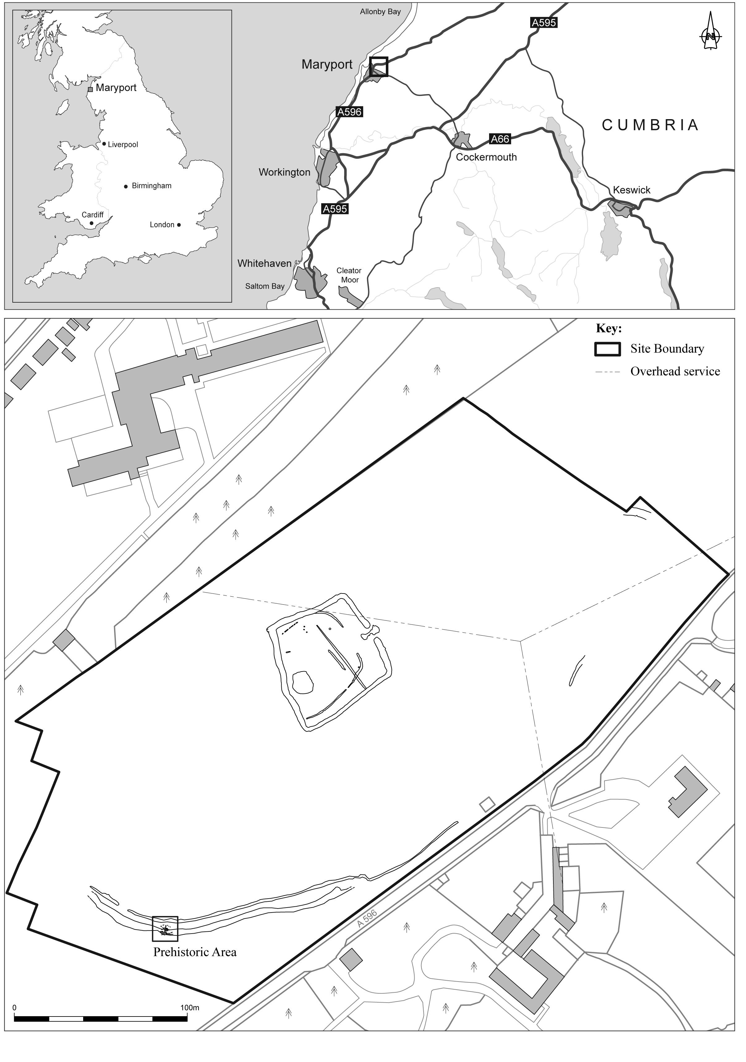
One of the Roman-period features subject to this programme of excavation consisted of a possible trackway with a drainage ditch cut along its upper side. This feature traversed the steeply sloping ground above the former floodplain of the River Ellen and had been cut into the hillside in order to create a level surface. During the excavation of this feature, an area of darker soil deposits was identified continuing beneath the colluvial deposits into which the Roman-period features had been cut. The recovery of a number of lithics from these deposits resulted in additional archaeological work being agreed with the Cumbria County Council Historic Environment Service (CCCHES). This work identified 37 cut features and resulted in a quantity of lithics being recovered. With the current evidence for Mesolithic activity in the north of England being heavily biased to the Pennines, and with nearly all the lowland evidence coming from eastern England (Cowell 2000), the discovery of a lowland site in such close proximity to England's west coast represents a significant discovery for Cumbria and the north-west region. The Roman-period features will be published elsewhere (Kirby forthcoming).
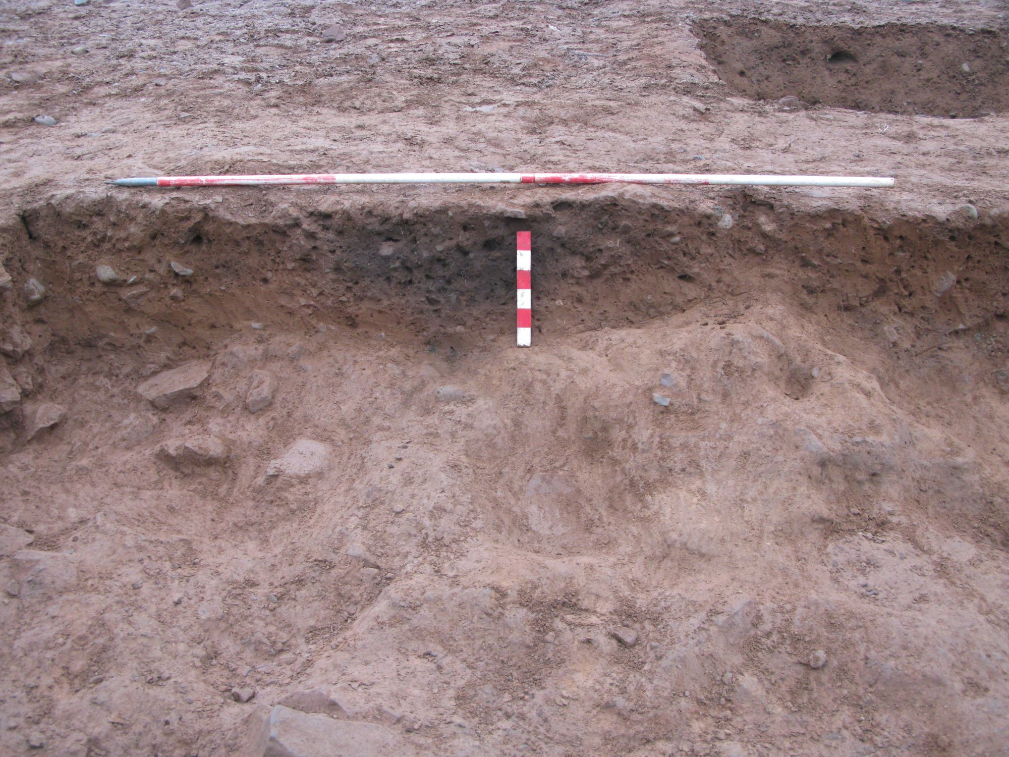
Within the area where the lithics were discovered, only very slight traces of the Roman-period track were identified cut into yellowish-orange colluvial deposits, with the cut (460) filled with white-grey sand (486/487) from which Roman-period pottery was recovered. During the course of the excavation, this part of the track was identified as having also been cut into much darker grey-brown silty-sand deposits (105 and 106) from which a number of lithics were recovered. As deposits 105 and 106 were partially overlain by colluvial deposits (457, 461 and 456/462), a narrow exploratory trench was hand excavated through these deposits. This trench uncovered a number of small negative features, and also recovered further lithics. Consequently, the trench was expanded to 7.5m east to west by 6.5m north to south in order to expose the full extent of the features (Figure 2, Figure 3).
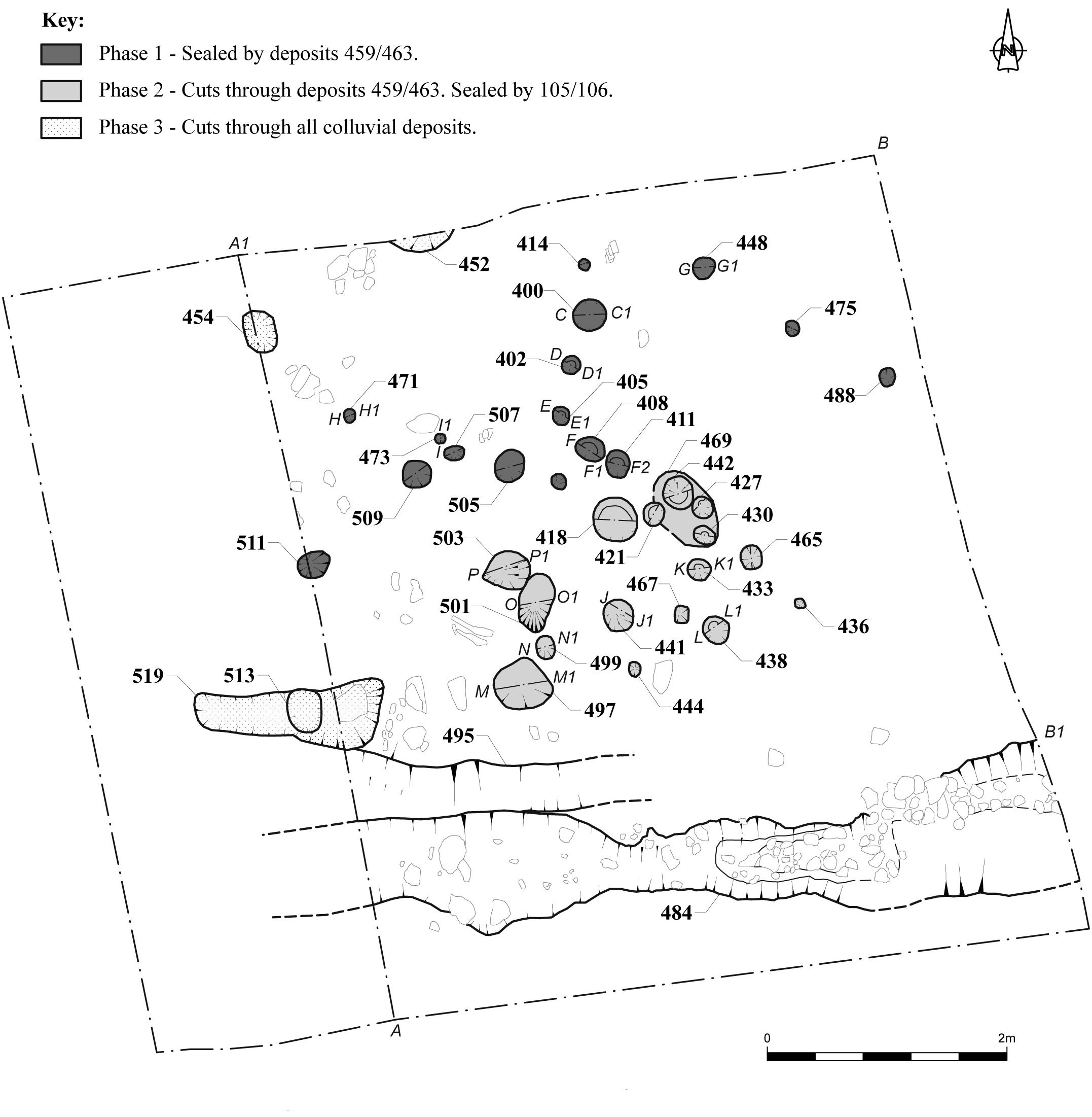
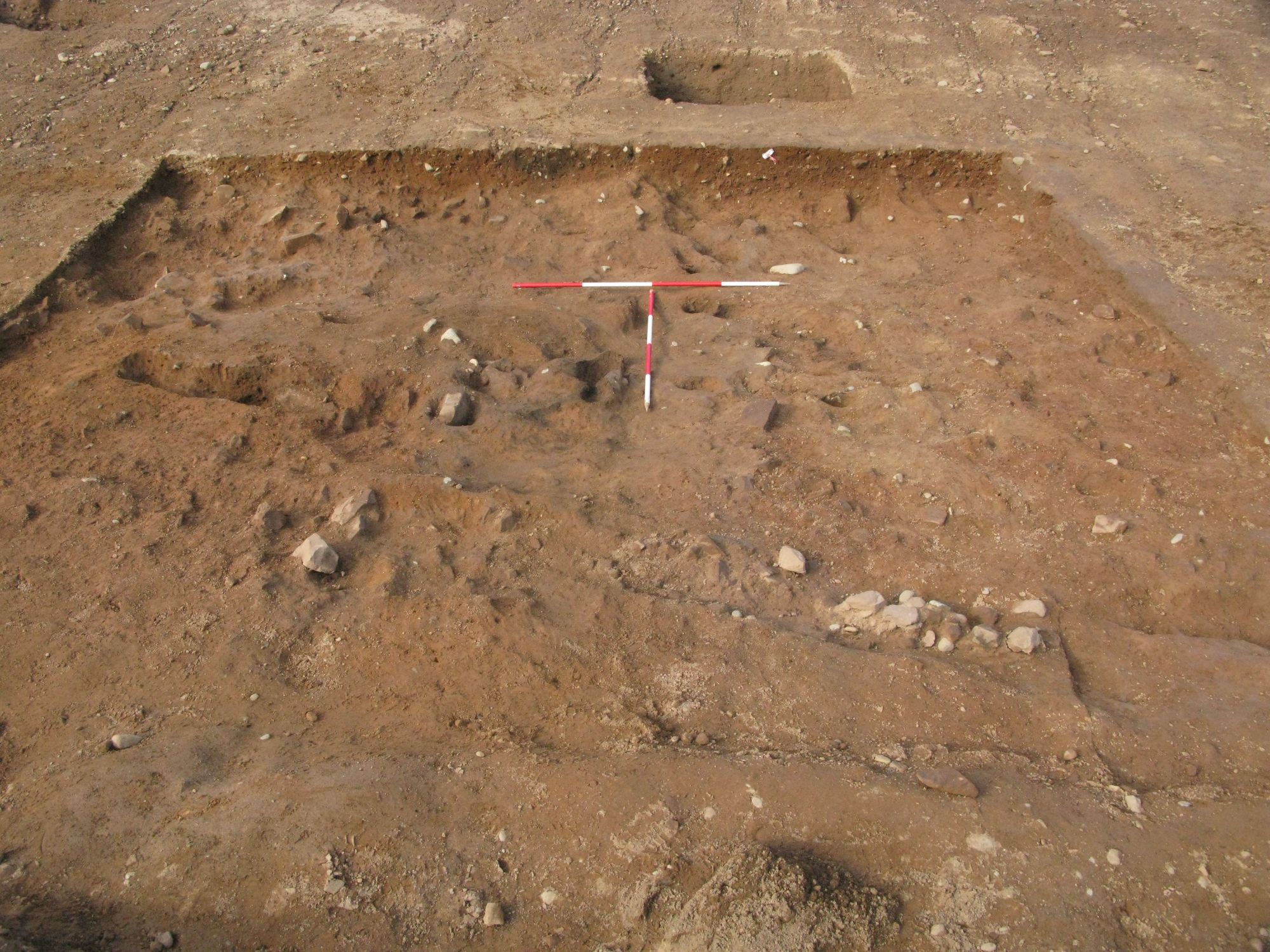
The results of this excavation suggest that there were at least three phases of activity (Phase 1 to Phase 3) (Figure 2, Figure 4). These phases of activity appear to have been interspersed with episodes of water runoff causing material to move down-slope, resulting in the build-up of colluvial deposits sealing the features and through which later features were then cut, resulting in a complex sequence (Figure 5); some features were recorded only in section. In plan, the features relating to Phase 1 are clustered in the northern half of the excavation area while the features relating to Phase 2 are clustered within the southern half. The low number of Phase 3 features are confined to the west and north. This distribution of features means that the phasing is not necessarily in vertical order on the section drawings, and phasing has generally been established by which layers of colluvial deposits have been cut by or seal features.
Stone-filled gully 484 at the southern end of the trench is thought to be a natural feature resulting from large stones moving down-slope and getting caught where the gradient slackened off, while gully 495 also appeared to be a natural colluvial-filled feature. Small quantities of lithics were also recovered from the Roman-period track fill (486). Details of the individual phases are given below.

The earliest phase of activity was represented by features 400, 402, 405, 408, 411, 414, 416, 448, 471, 473, 475, 488, 505, 507, 509 and 511 (Figure 6). All of these features were spread out across the northern end of the trench and consisted of small pits. Although some of these features appeared to form lines, there were no definite structures identified.
The pits had all been cut directly into natural sand deposit 464 and had been sealed by colluvial deposit 459/463 (Figure 5, Figure 6). The majority of these features had fills consisting of dark grey-brown sandy-silt and orange brown silty sand containing Corylus avellana (Hazel) nutshell and charcoal The largest of these pits (400) had a diameter of c. 0.38m and a depth of 0.41m.

Tuff was recovered from features 400, 402, 408, 411, 471 and 505 (108 pieces total), and flint was recovered from features 400, 402, 408, 411, 448, 471, 505 and 509 (14 pieces total). A small quantity of chert (2 pieces) was also recovered from feature 405 (see Appendix A).
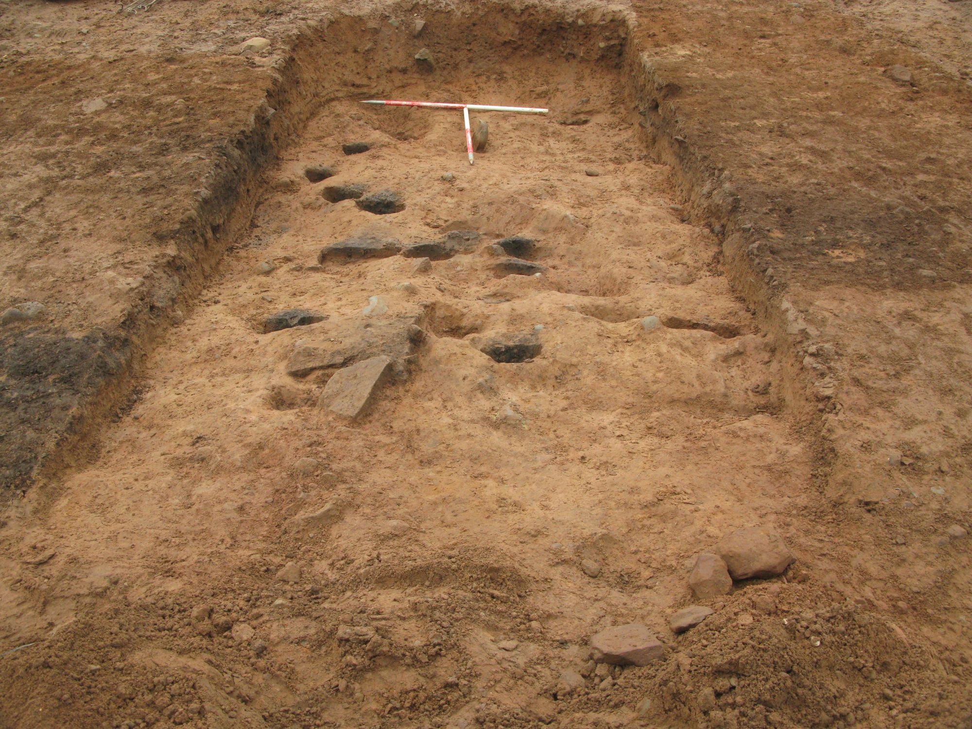
The next phase of activity was represented by features 418, 421, 424, 427, 430, 433, 436, 438, 441, 444, 465, 467, 469, 497, 499, 501 and 503 (Figure 7). All of these features were concentrated within the centre of the trench and consisted of small pits. Like Phase 1, there were no definite structures identified.
The pits had all been cut into colluvial deposit 459/463 (which sealed the Phase 1 features), with the deeper features extending down into the underlying natural (464) (Figure 5). Four of these features (421, 424, 427 and 430) were located within a shallow hollow or depression (469). The majority of the pits had fills consisting of dark grey-brown sandy-silt and orange brown silty sand containing Corylus avellana (Hazel) nutshell and charcoal. Pits 444 and 467 were overlain by a spread of material (446 and 447), which was very similar in nature to their fills. The largest of these features (497) measured 0.46m by 0.42m by 0.12m deep.
These features were either overlain by deposits 105 or 106, or by colluvial deposits (456, 457, 461, 462), which partially overlay 105 and 106 (together referred to as Phase 2b).

Tuff was recovered from pits 424, 427, 430, 438, 444, 465, 497, 501 and 503 (11 pieces total) and flint was recovered from 418, 424, 427, 430, 438, 441, 465, 497, 499, 501 and 503 (49 pieces total). Single pieces of chert and banded tuff were also recovered from pits 497 and 502 respectively. Large quantities of flint (501 pieces, 77% of total flint) and tuff (225 pieces, 45% of total tuff) were recovered from deposits 105 and 106, as well as smaller quantities coming from overlying (Phase 3) deposits 456, 461, 462 (29 pieces total). Flint and tuff was also recovered from spreads 446 and 447 (1 and 4 pieces respectively (see Appendix A).
The final phase of activity (Phase 3) was represented by features 452, 454, 482 and 513/519. These features had been cut through the colluvial deposits from the same level as the Roman-period features (Figure 8). Deposit 481, which sealed Pit 452, is thought to be the same as subsoil 002, which was identified sealing much of the Roman-period features. Feature 454 extended through the colluvial deposits into the underlying natural (464). It measured 0.36m by 0.24m by 0.56m deep and had an upper fill (455) consisting of dark-brown sandy-silt and a lower fill consisting of brown sand. Pit 513 consisted of a linear pit with a smaller pit (519) cut into it. This pit measured 1.5m by 0.6m by 0.18m deep and contained a single fill (514) consisting of dark-grey sandy-silt. Tuff and flint were recovered from the fills of pits 454 (6 pieces total) and 513 (107 pieces total) (fills 455 and 514 respectively). Pit 513 also contained five pieces of chert and two pieces of rhyolite. A single flint core was recovered from deposit 481 overlying pit 452, while deposit 520 contained 11 pieces of flint and 26 of tuff (see Appendix A).
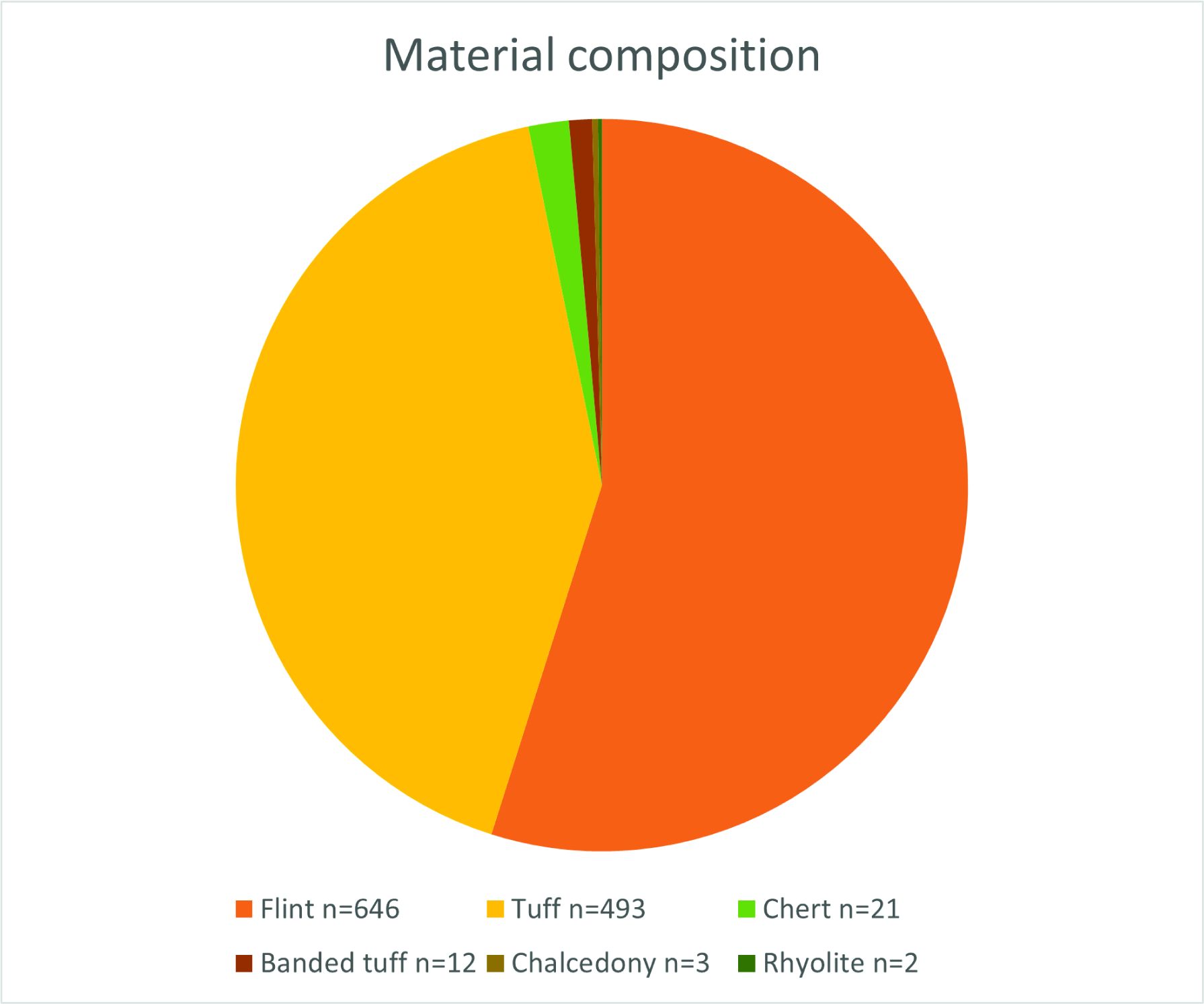
In total, 1177 flaked lithics were recovered from the excavation. The lithics were hand-collected from features and through sample processing. They were not individually 3-D recorded and consequently there is no further information for how the lithics were distributed within the layers and across the site. Several different materials were used including flint, tuff, chert, banded tuff, chalcedony, and rhyolite (Table 1, Fig. 9, and see Appendix A for concordances of material, artefact type and context and Appendix B for definition of lithic terms). A worked cobble tool was also recovered.
| B | RF | FF/IF | SF | Core/pebble | Ret | Chunk | TOTAL | |
|---|---|---|---|---|---|---|---|---|
| Flint | 75 | 61 | 129 | 334 | 11 | 23 | 13 | 646 |
| Tuff | 146 | 72 | 37 | 217 | 7 | 11 | 3 | 493 |
| Banded tuff | 4 | 4 | 1 | 3 | 12 | |||
| Chert | 9 | 4 | 2 | 4 | 2 | 21 | ||
| Chalcedony | 1 | 2 | 3 | |||||
| Rhyolite | 2 | 2 | ||||||
| 235 | 143 | 171 | 558 | 20 | 34 | 16 | 1177 |
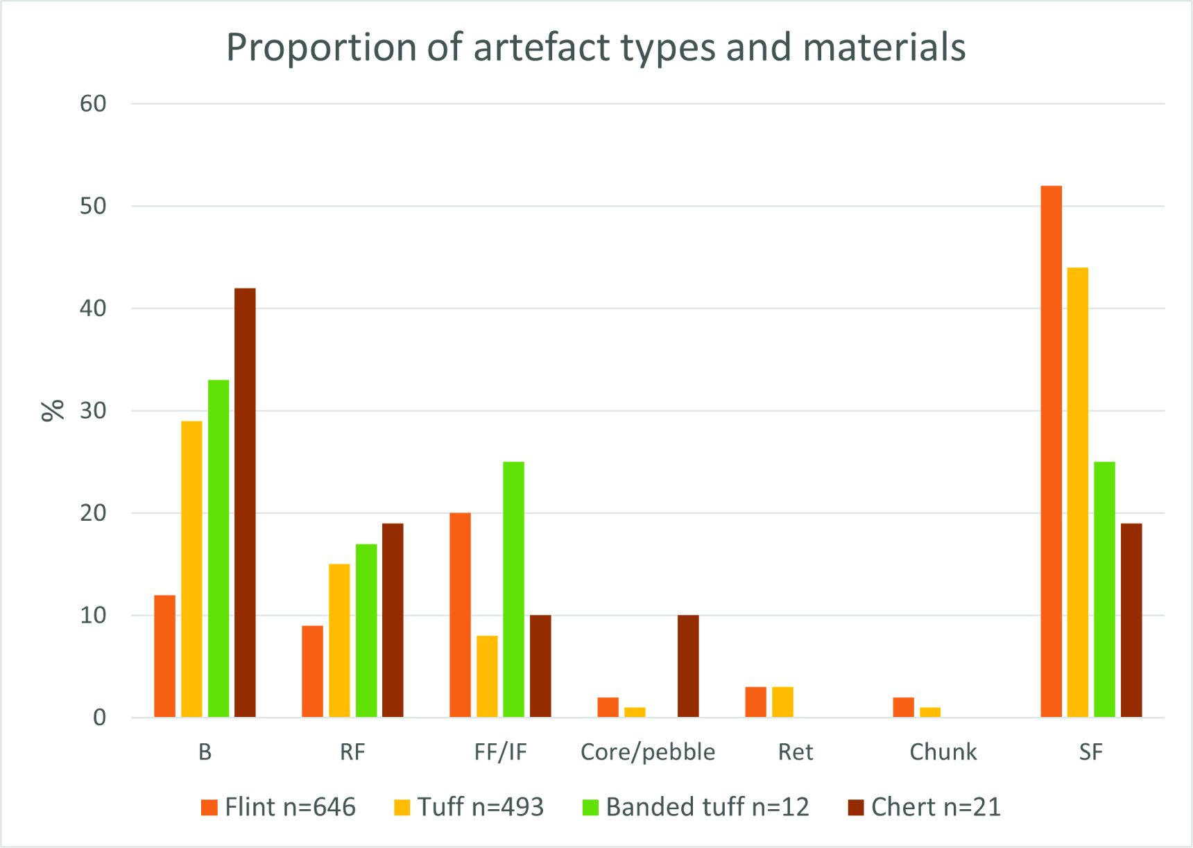
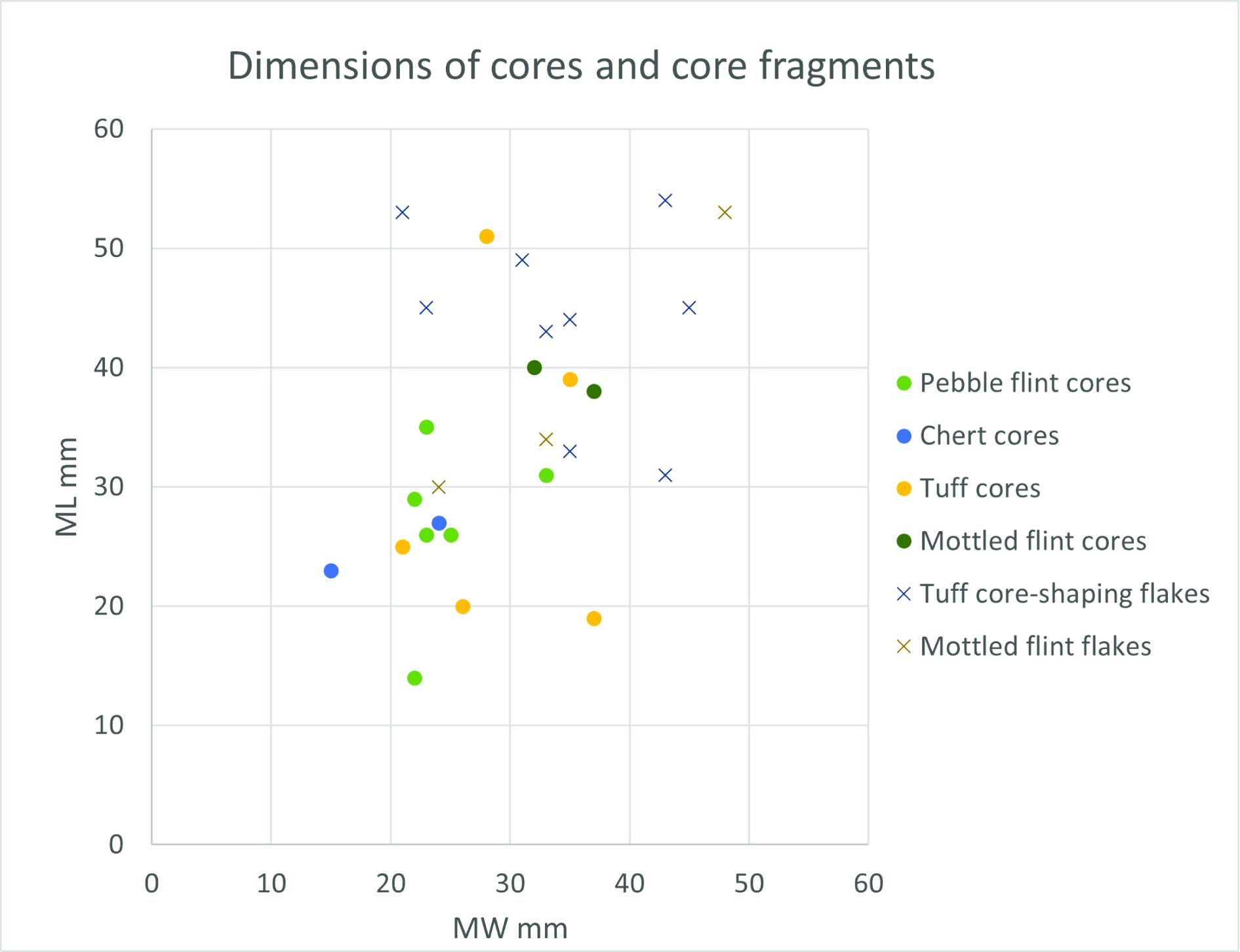
The flaked lithics assemblage is composed predominantly of flint and tuff, together with a few pieces of chert, banded rhyolite, and chalcedony (Figure 10, Table 1).

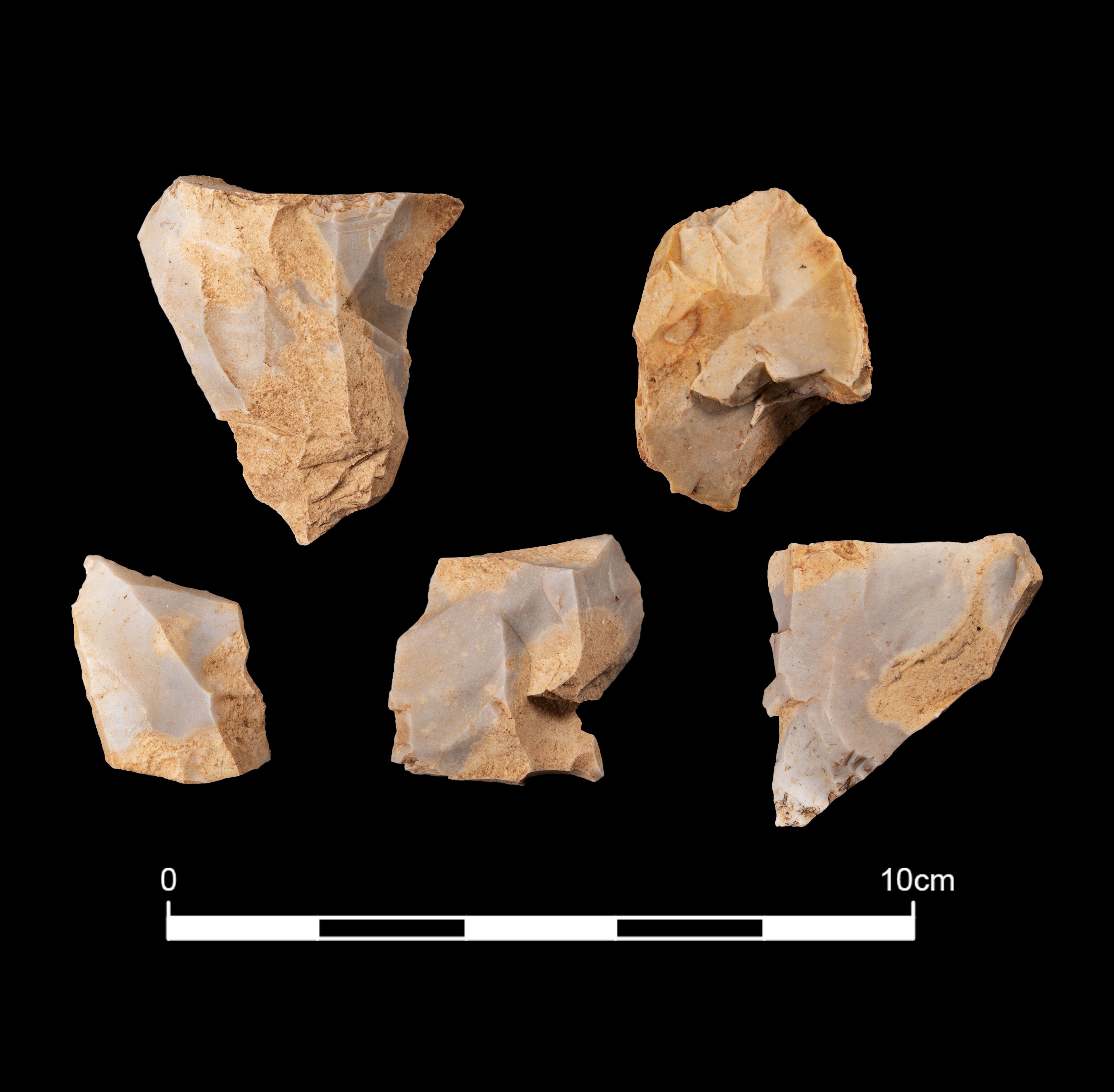
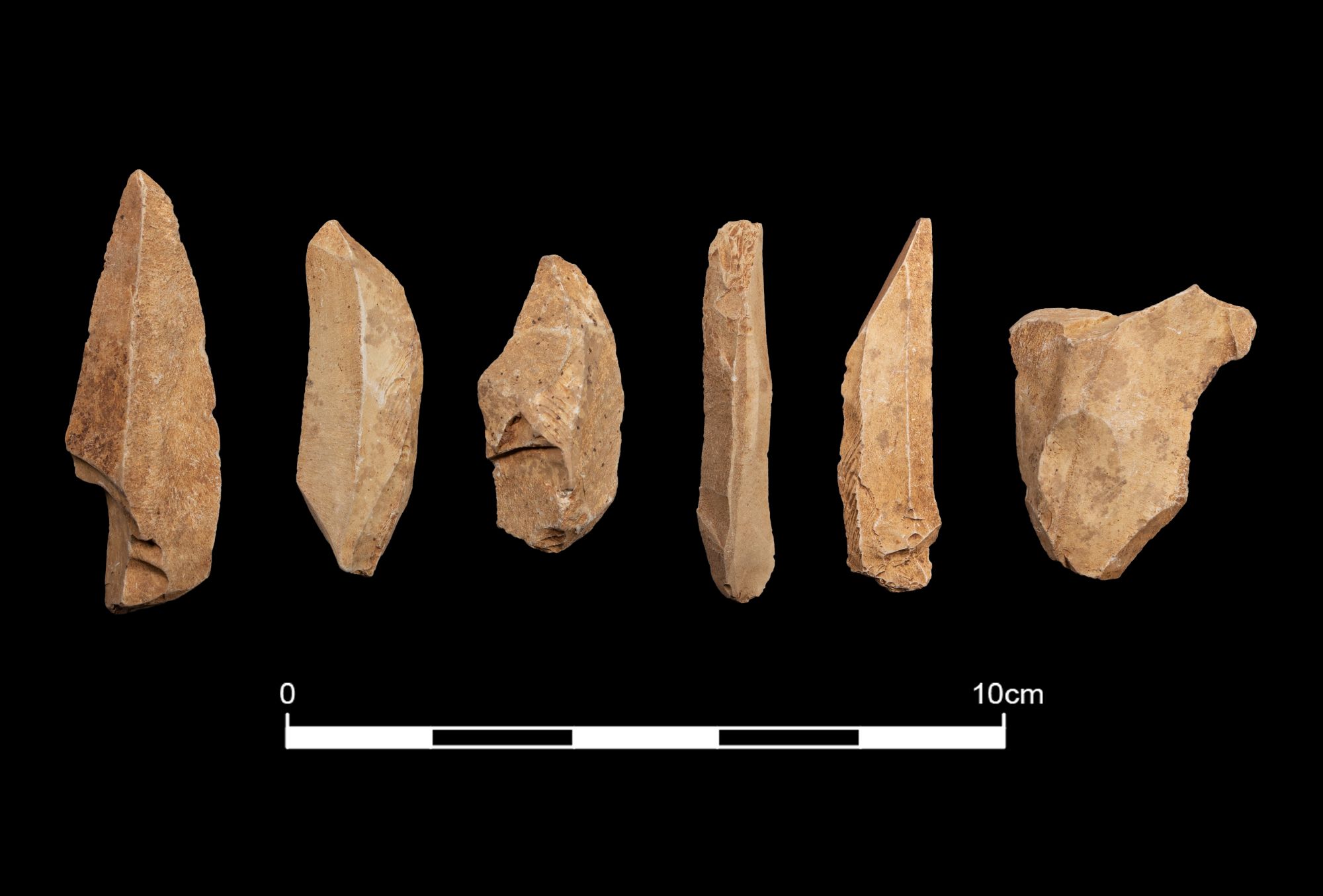
The rolled pebble cortex on much of the flint (Figure 11, Figure 12) indicates that it was derived from rolled gravel deposits, most likely the beach pebbles that would have been available for collection along the west Cumbrian coast. The Mesolithic coastline would have been at least 1km further away from the present site location (see Section 6). The pebble flint occurs in many shades of grey and brown with some visible mottling. A small group of worked flints was made from a distinctive blue/grey flint mottled with a coarser light brown material (Figure 13), and though some pebble cortex was present to indicate a gravel source, this flint is so different to the common grey pebbles (and was worked differently, see Section 3.2.1) that it is probably from a different gravel source to the Cumbrian flint. A small group of white flint flakes and blades also appear as a different material to the norm and Antony Dickson has observed this flint to occur in other collections around Cumbria (Dickson pers. comm.).
For the most part the flint was collected locally (or at least at locations up and down the Mesolithic coastline) while the mottled blue and brown flint and the white flint may have been brought in to the site from unknown locations further afield.
Tuff is the term used here for a volcaniclastic siltstone that occurs in the Lake District. Much of the tuff from Maryport is a dark blue-green colour and has weak cleavage, which is typical of the best quality tuff from the Central Lake District. This is normally referred to in the literature as Langdale tuff (Dr David Millward pers. comm.) and is the same quality of material that was quarried and manufactured into axes during the Neolithic (Group VI rock). The Group VI source of tuff has been the subject of much investigation, enabling the identification of the individual outcrops/quarries from which the stone for ground axes originated (Bradley and Edmonds 1993). No accurate geological identification or sourcing work has been done on the Maryport tuff for this project, and therefore the precise source(s) of the material is not known. However, the geologist, Dr David Millward, was confident about the quality of the tuff and its probable derivation from the Langdale outcrops. The potential for using geological sourcing to investigate the site formation is discussed in Section 8.
As well as the homogeneous fine-grained material, other tuff shows some variation in its texture as some layers of the siltstone are coarser grained than others. This variability can occur within the same block of material and when this is present it is clear that the coarse-grained material weathers differently and can appear more abraded than the fine-grained siltstones.
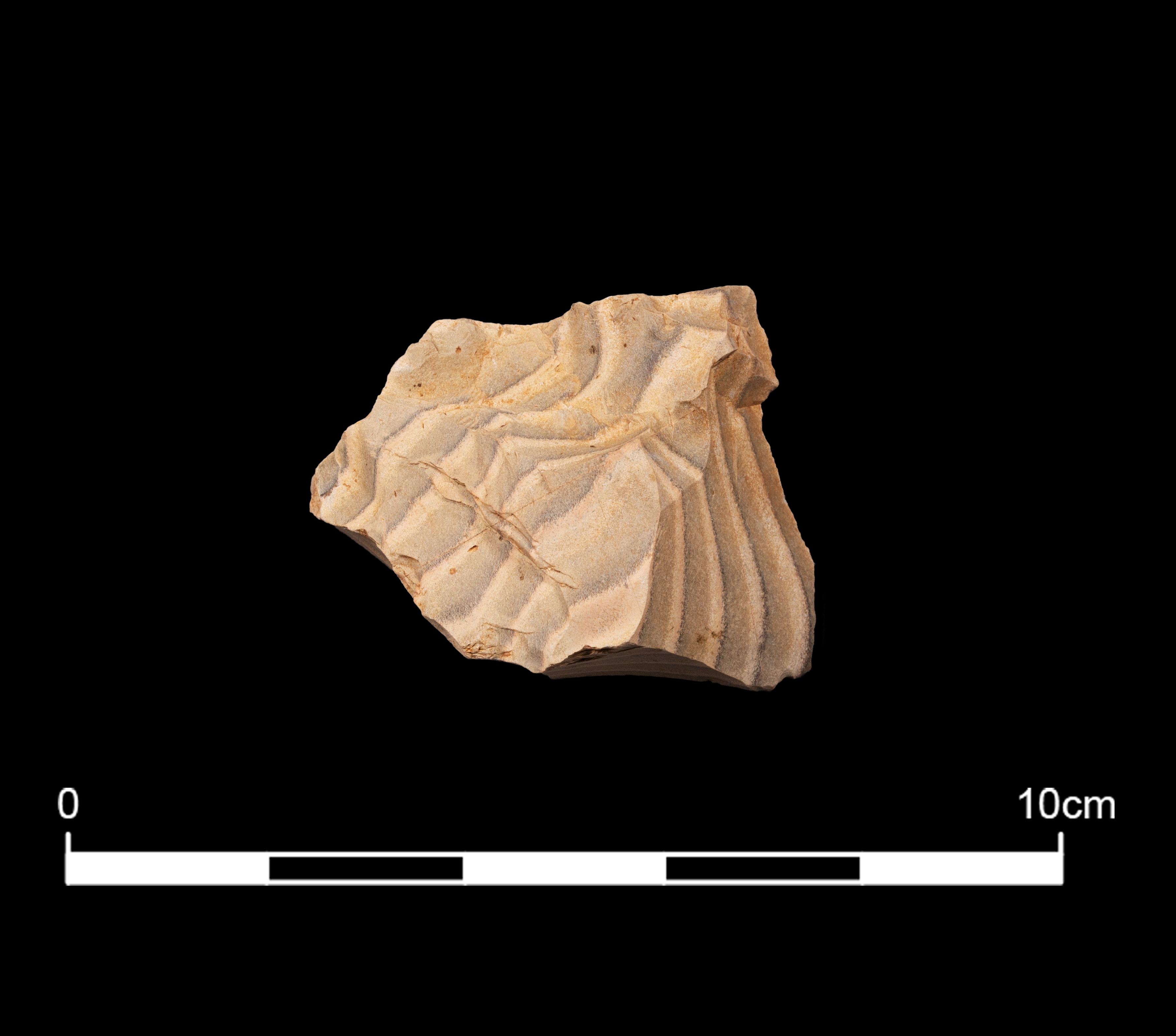
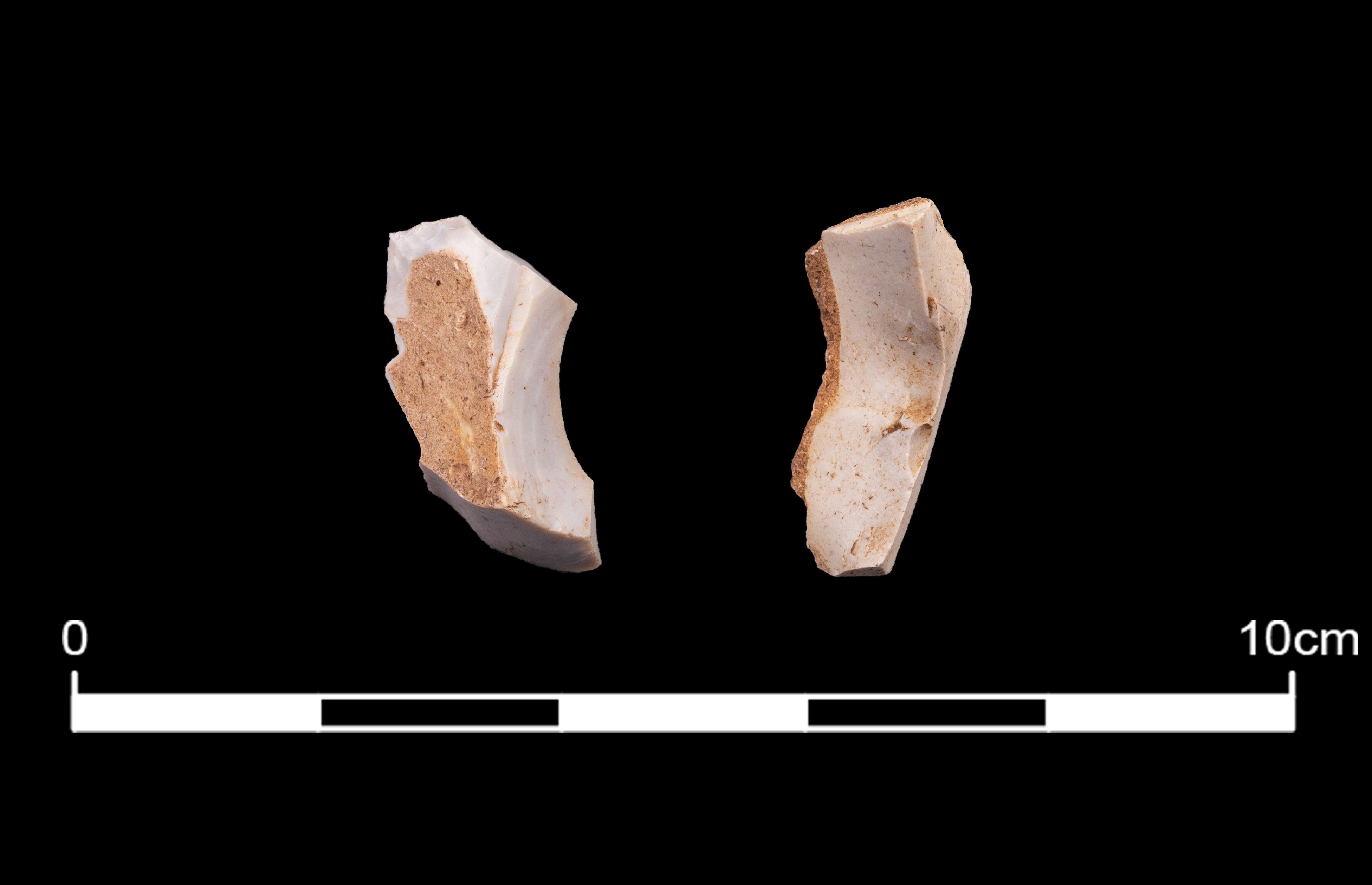
A few examples of banded tuff (or, in strict geological terms, laminated volcaniclastic siltstone) are present and are particularly attractive, with regular and finely coloured dark to light blue-green bands (Figure 14). The laminated structure formed by the fine-grained to coarser grained silts creates a stepped surface when flaked and therefore does not present as fine a regular edge as the homogeneous blue tuff. The distinctive banded tuff occurs around the Lake District (Dr David Millward pers. comm.).
None of the tuff bears any evidence of rolled surfaces, indicating that neither cobbles nor pebbles were selected as raw material. A weathered surface is present on just one piece, a blade (514.16), indicating that it had been detached from a weathered angular block. It could be argued that the outer cortical surface of a cobble, pebble or weathered block was removed completely and left at source with the intention of bringing only the fresh inner material to the site at Maryport. However, a physical feature of the tuff is the presence of joints that cause the rock to split cleanly thus forming flat faces, often diagonally across the piece of flaked tuff (e.g. Figure 17, 106.65; Figure 18, 105.85, 105.87). The cores have flat, angular faces (see 3.2.2) and this, together with the jointing, indicates that the original blocks had not been subject to a high-energy environment such as a river, which would surely have resulted in smaller rounder pieces. Given that the tuff blocks had not been subject to mechanical or chemical weathering at altitude, it would seem that they were collected as fresh, angular blocks at source, possibly prised from the rock face or removed from the fresh scree associated with the outcrops of tuff in the Langdale area.

The condition of the worked tuff varies considerably. Unlike flint, which had clear evidence for burning, there was no obvious cracking or crazing on the tuff. That said, the lack of research as to the effects of burning on tuff limit the identification of the burnt material.
Different degrees of surface alteration were nevertheless particularly noticeable on the tuff. This was divided subjectively by eye into four main categories:
As mentioned above, the various textures of tuff can weather differently even though they were flaked at the same time, and this undoubtedly complicates interpretations of the assemblage formation using surface alteration as a key. However, there appears to be a relationship between blade length and surface alteration, suggesting that age was a stronger factor in surface weathering than simply the original material structure (see Section 3.4).
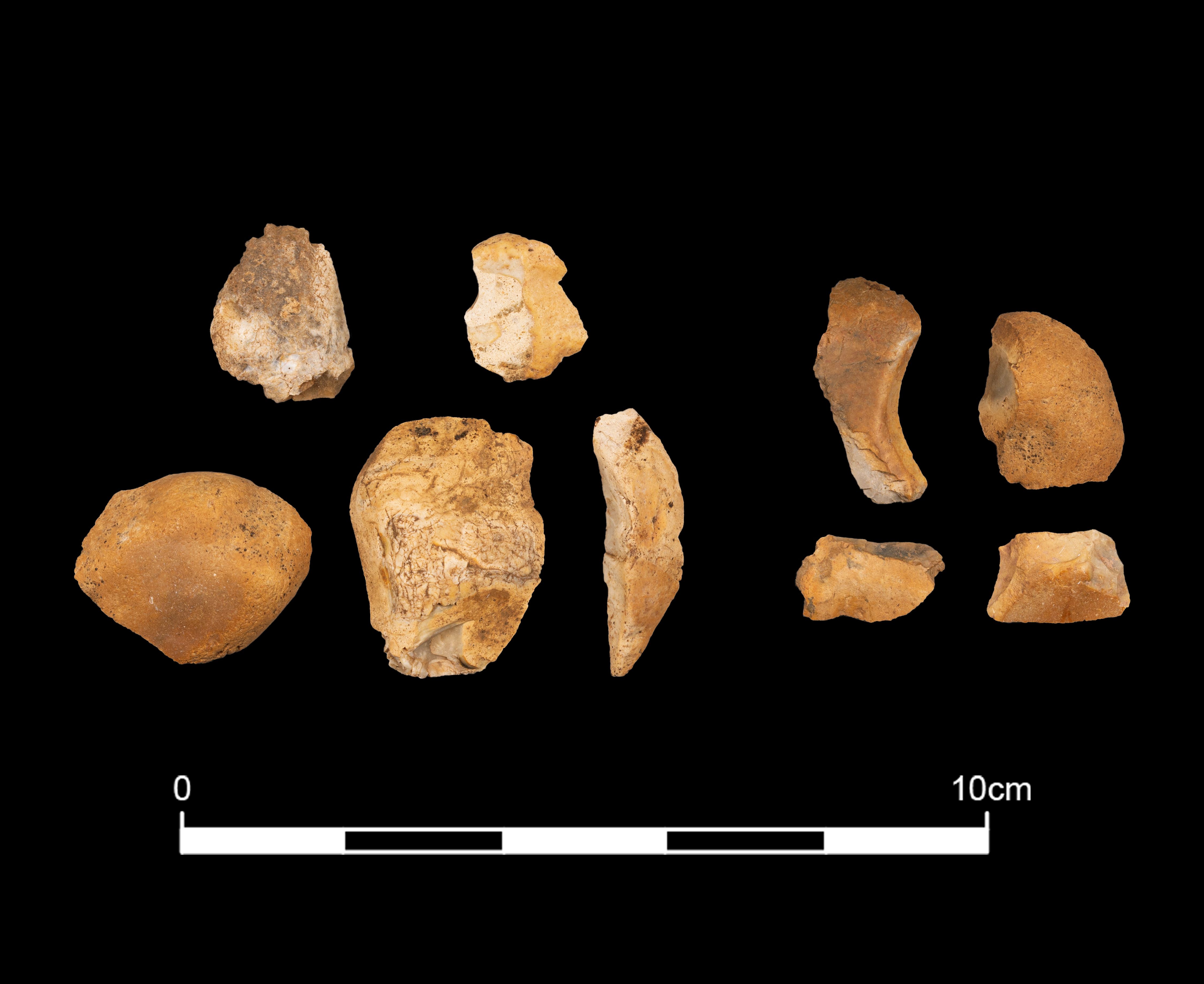
Chert was used for a small number of tools at Maryport. A group of small flakes and blades (Figure 19, 105.330-5) were made from black carboniferous chert bearing traces of fossil shell, and the rolled pebble cortex on the surface of two of the flakes indicates it was collected from a pebble source. Carboniferous chert comes from Pennine sources in north England, though chert is available more locally in the Limestone Uplands that skirt the eastern edges of the Lake District some 40km to the east of Maryport. Worked chert from the Late Mesolithic site at Stainton West has been geochemically matched to geological material from the Caldbeck area in the north-eastern edge of the Lake District (Brown et al. in press a). Other blades are made from green/blue Radiolarian chert, whose source is the southern uplands of Scotland some 150km to the north. It was not possible to identify a specific chert type for the rest of the chert assemblage.
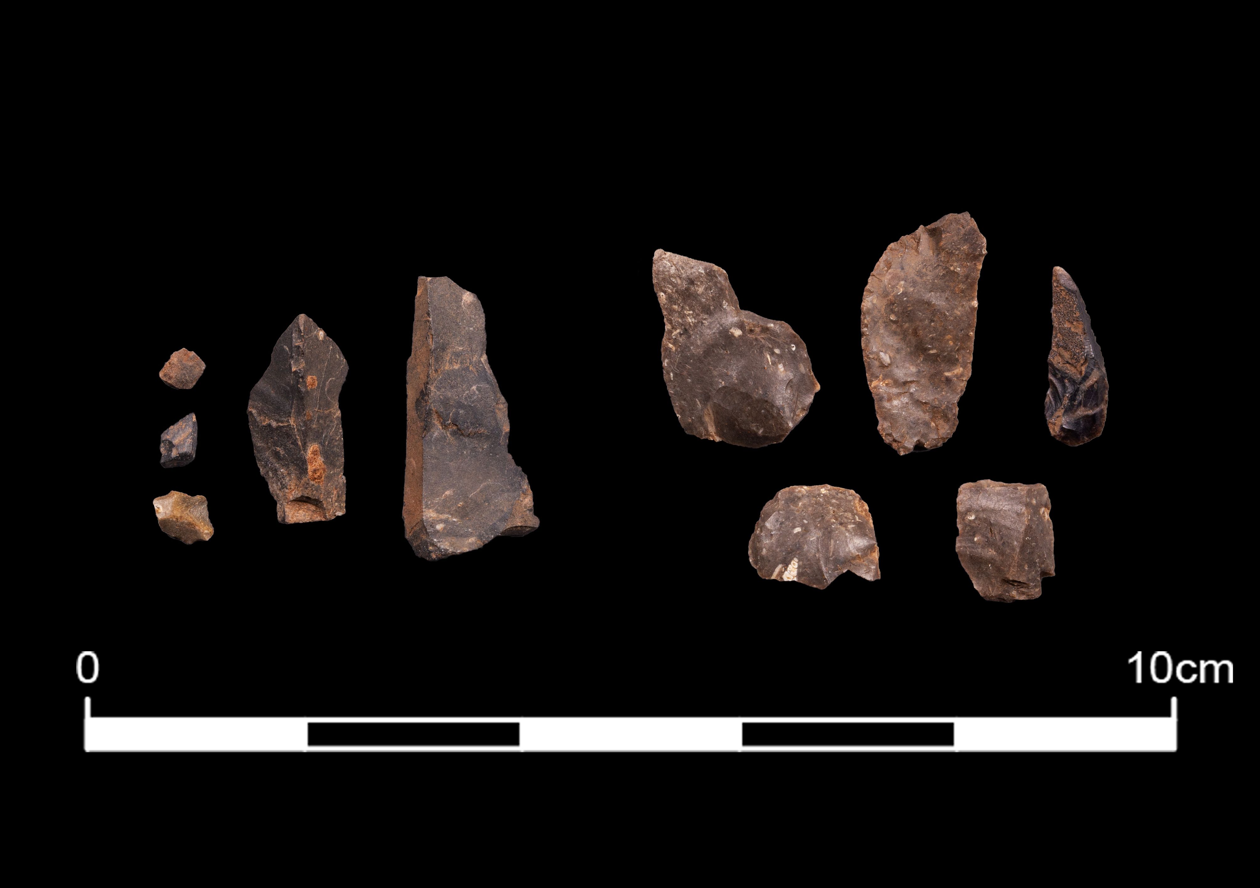
A blade and two flakes of chalcedony were also present. These are milky blue in colour with what appeared to be country rock adhering to the exterior, indicating that it came from a vein rather than a rolled source (Figure 20). The source of this material is not known though chalcedony is recorded within the Borrowdale Volcanic Group of the central Lake District (Stone et al. 2010).
Two flakes of rhyolite were present that were identified from traces of flow-banding and perlitic cracks (Dr David Millward pers. comm.). Rhyolite is found in the central Lake District and it was likely to have been collected by people travelling through the region.
Flint, tuff and, to a lesser degree chert, were all worked from cores to produce tools and tool blanks. The presence of debitage indicates that this took place on site and different techniques were employed for each material.
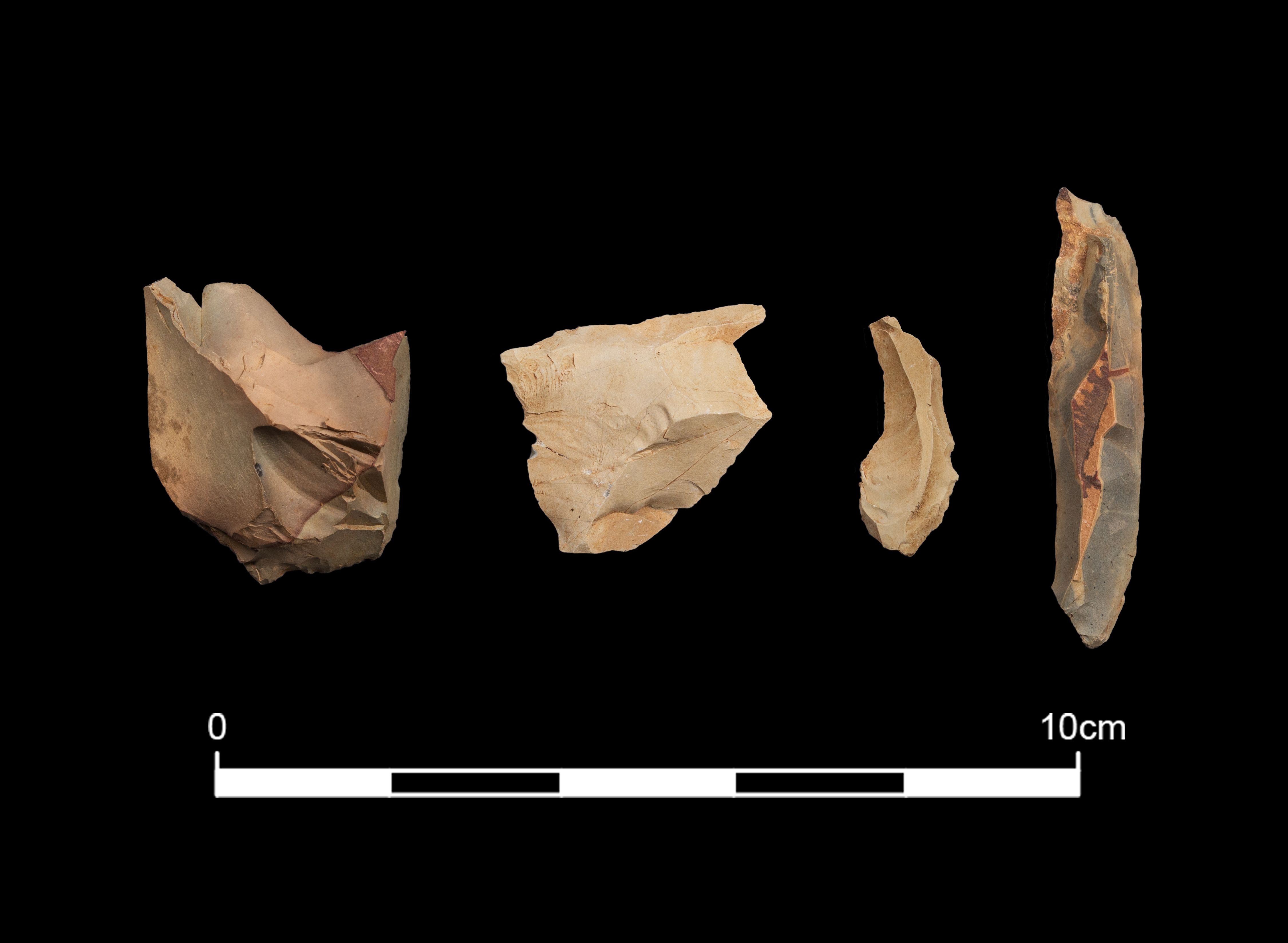
Two different knapping strategies were used, both of which were aimed at making flint blades. The first technique was used to create broad blades from opposed platform cores. This is represented by a group of five large pieces of flint of a distinctive blue/grey colour mottled with a coarser light brown material (105.299-303) (Figure 13, Figure 21, Figure 22). Two of these pieces are cores, one of which is a fragment of an opposed platform core with an oblique platform (105.299) (Figure 21). The other core (105.303) (Figure 21) has some remnant rolled cortex, indicating it had been collected from gravel deposits. This piece was turned frequently to remove irregular flakes, most likely in order to test the flint. The three other pieces in this group are large flakes. One (105.300) (Figure 21) is from an opposed platform blade core – it has a deep platform and may have been detached to remove a step fracture. Another broad flake (105.301) (Figure 21) is knapped from a dihedral platform (where the platform is formed on previous blade scars) indicating the core had been turned and this also exhibits blade scars made from opposed platforms. The third flake has been detached to remove internal step flaws (105.302) (Figure 21). Blade scars vary from about 10mm to 14mm in width. No refits could be identified among these pieces but the distinctive material suggests the flint was knapped in situ or, at least, that a group of flakes and cores from knapping the same nodule were present together. Unfortunately, the individual lithic finds were not recorded spatially so there is no record of how closely this group of lithics was associated within the context. However, the presence of a knapping event such as this has implications for how the lithics accumulated in layer 105 (see Section 7).
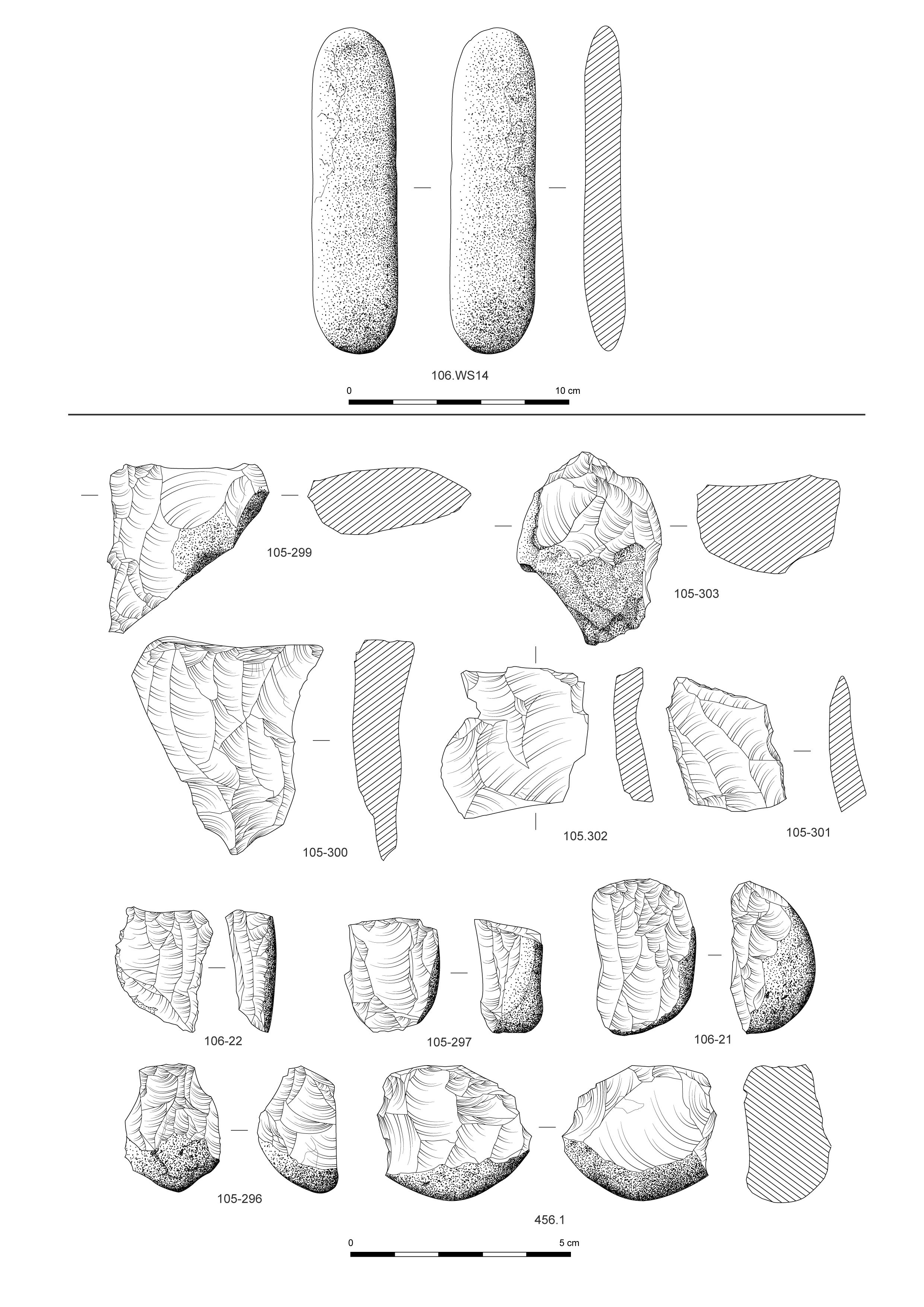
The rest of the cores were made using smaller flint pebbles or fragments of pebbles and are characteristically flaked from a single flat platform. The platform is created by removing a primary flake from the end of a pebble and then another flake is removed from the flat platform to create a face against which to work. Blades and flakes are detached from the inner platform working towards a cortical back (105.297; 106.21) (Figure 21). One core has been abandoned because of irregularities in the material, which has caused step fractures (105.296) (Figure 21). This was subsequently burnt. A thinner core (106.22) (Figure 21) appears to have been worked from a thick primary flake or split pebble. The smallest core (105.298) is simply a worked fragment. Blade scars on these pebble cores range from 6mm to 12mm in width.
Core 456.1 (Figure 21) has also been flaked towards a flat back but additionally there is some attempt to detach flakes at right angles to the original platform, probably in an attempt to create a fresh platform or flaking face.
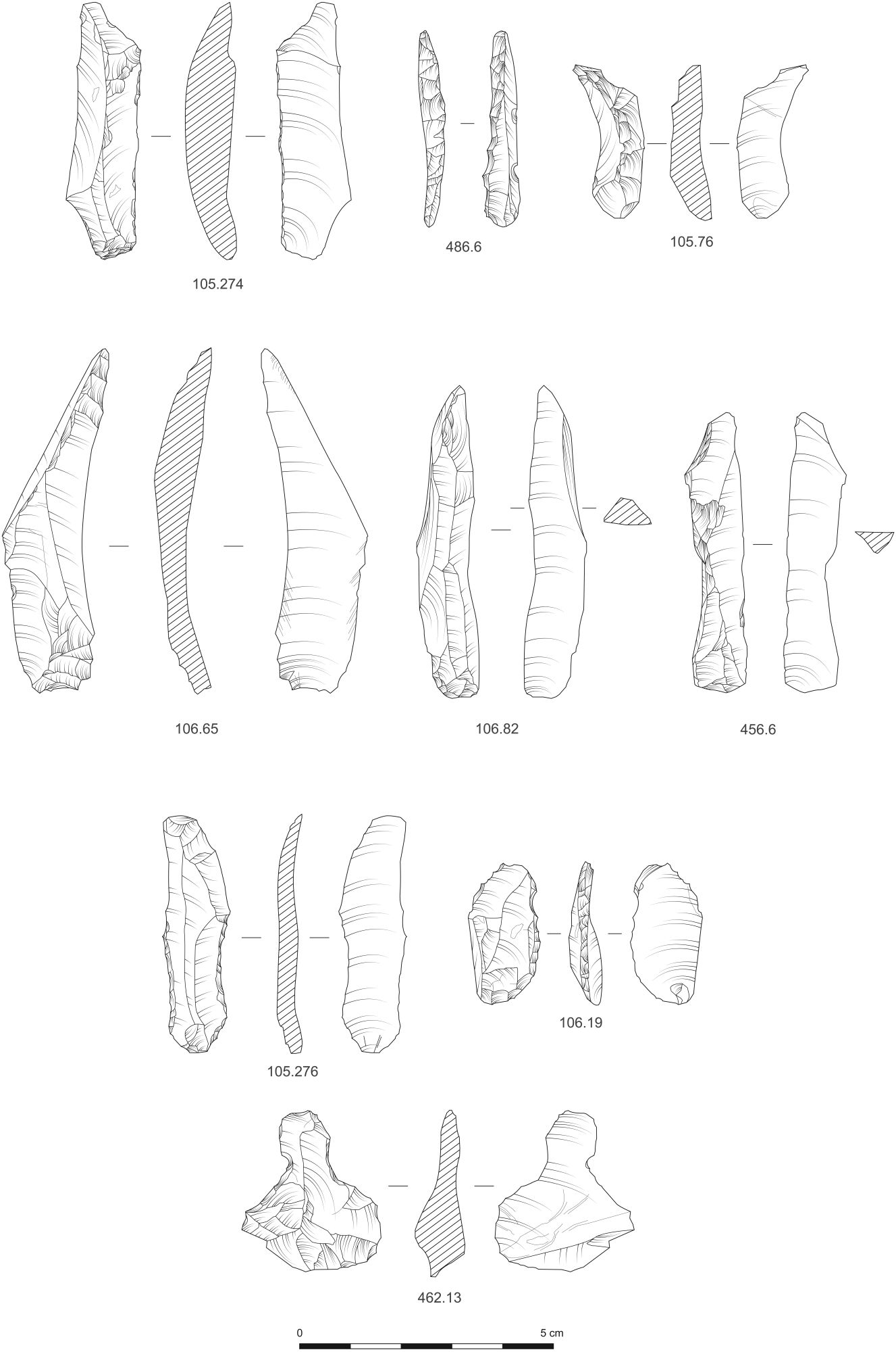
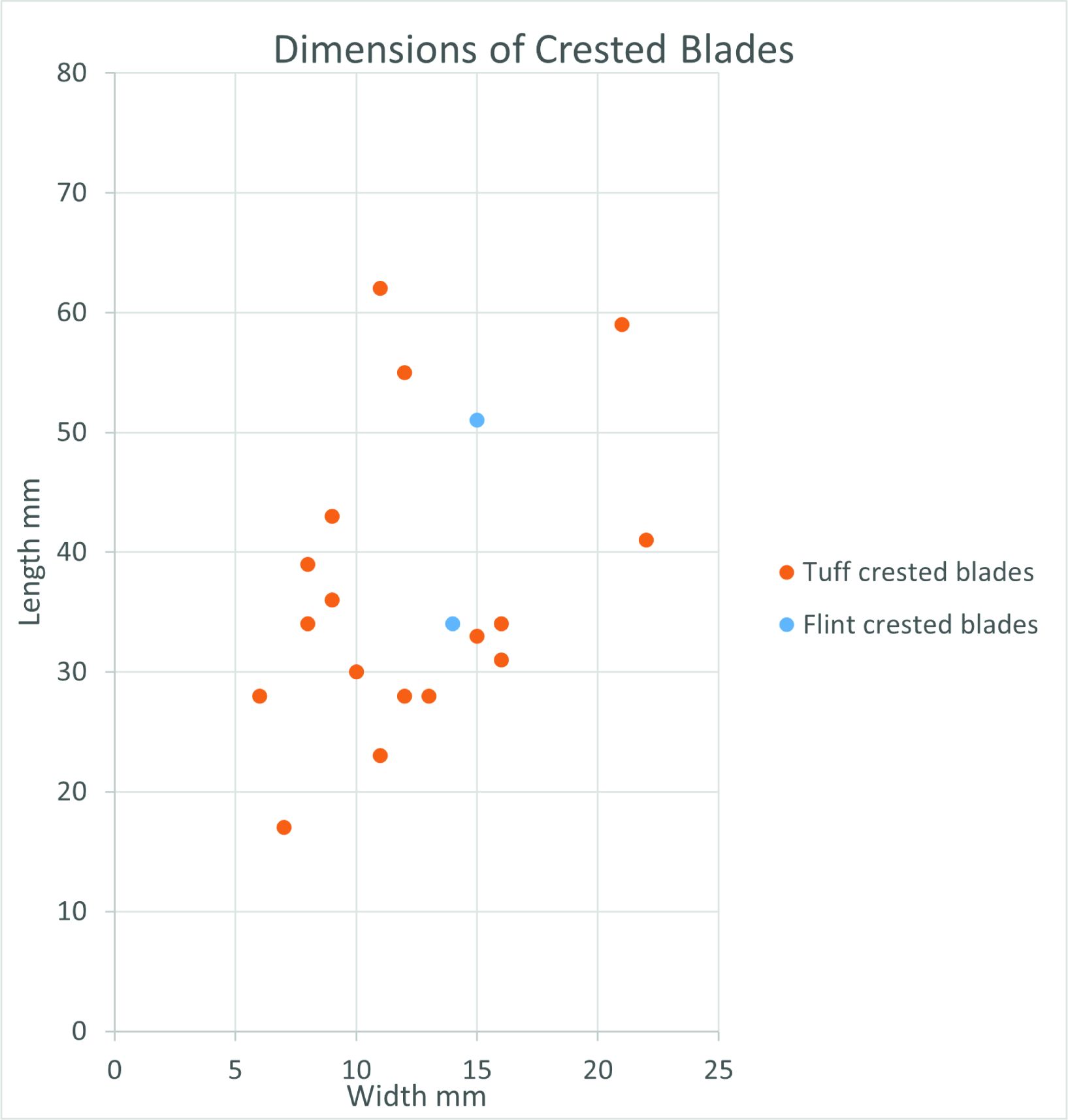
Other evidence in the flint assemblage to support the simple core-working technique is shown by the numbers of primary and secondary cortical flakes, which are a product of preparing the original pebble for blade removals (Figure 11). This is in contrast to the blades, which have a smaller proportion of cortical pieces. Four crested flint blades (105.274) (Figure 23) were recorded indicating that this technique was occasionally used to produce regular-shaped blades at this site. These are among the longest blades recorded in the assemblage (34mm and 51mm in length for complete specimens) and longer than most of the flint cores present, which would show that they had been detached from much larger pebbles or cores than are recorded here (Figure 25). Three core trimming flakes include two from blade cores, one of which (105.300) (Figure 21) is of mottled blue flint from an opposed platform blade core.
Visible platforms were missing on the majority of flint blades and flakes and, where evidence did survive, they were flat narrow to broad platforms. Only six blades had signs of abrasion on the edge of the platform, five of which were longer than 34mm; these blades were a product of a different knapping strategy designed to produce longer blades. Slight lips, indicative of hard hammer use, were present on just three blades and one flake.
Blocks of tuff were flaked to shape to produce blanks from which blades were detached from opposed platforms or platforms made at right angles to each other.
The surviving cores are mainly fragments of larger pieces where the core has split along the natural rock joints during knapping.
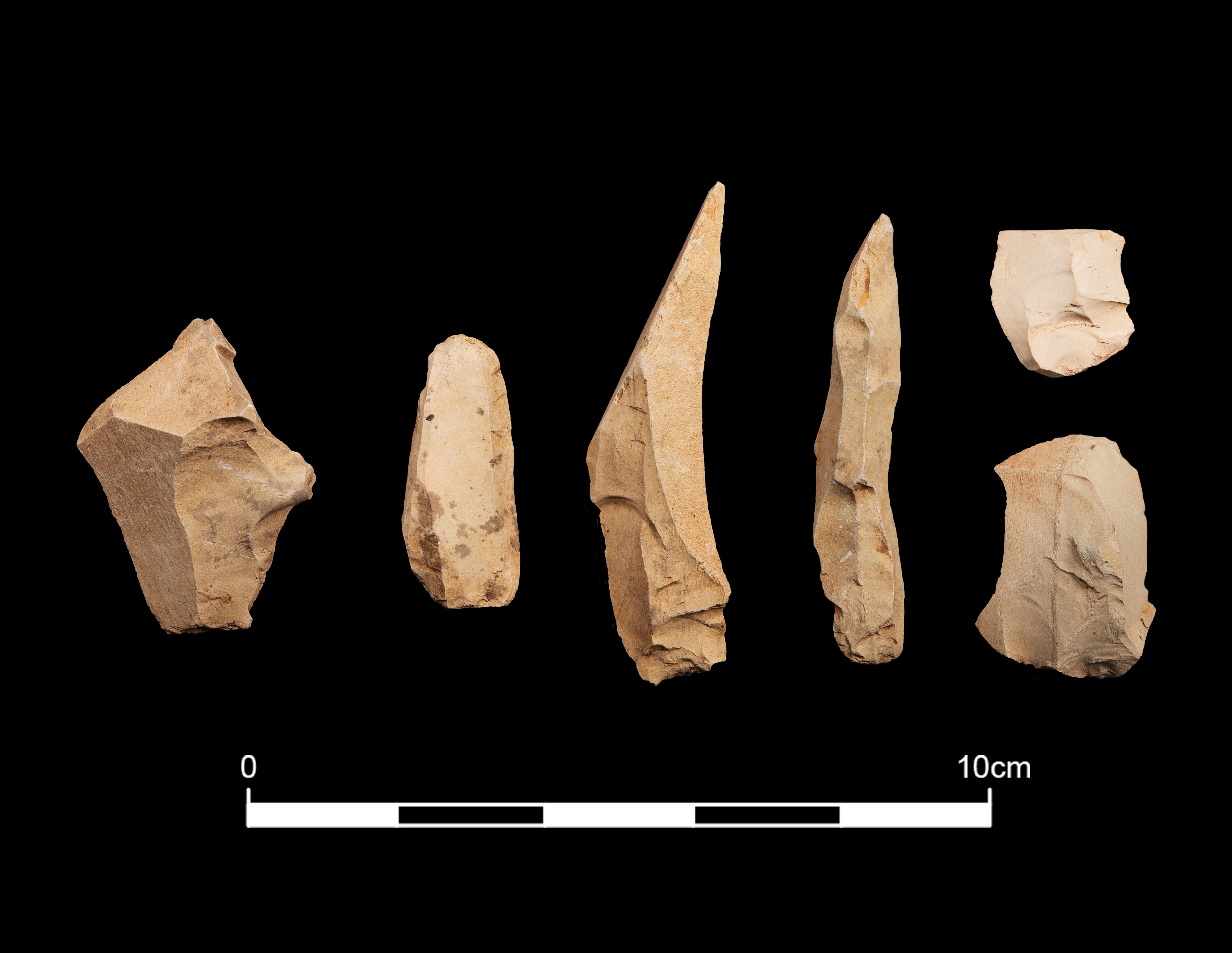
The two most distinctive cores have oblique platforms, one of which has had blades detached from opposed oblique platforms (481.1) (Figure 24). The other is a large core fragment with an oblique platform from which blades have been detached and then the core was turned at right angles to flake from another platform (105.52) (Figure 24).
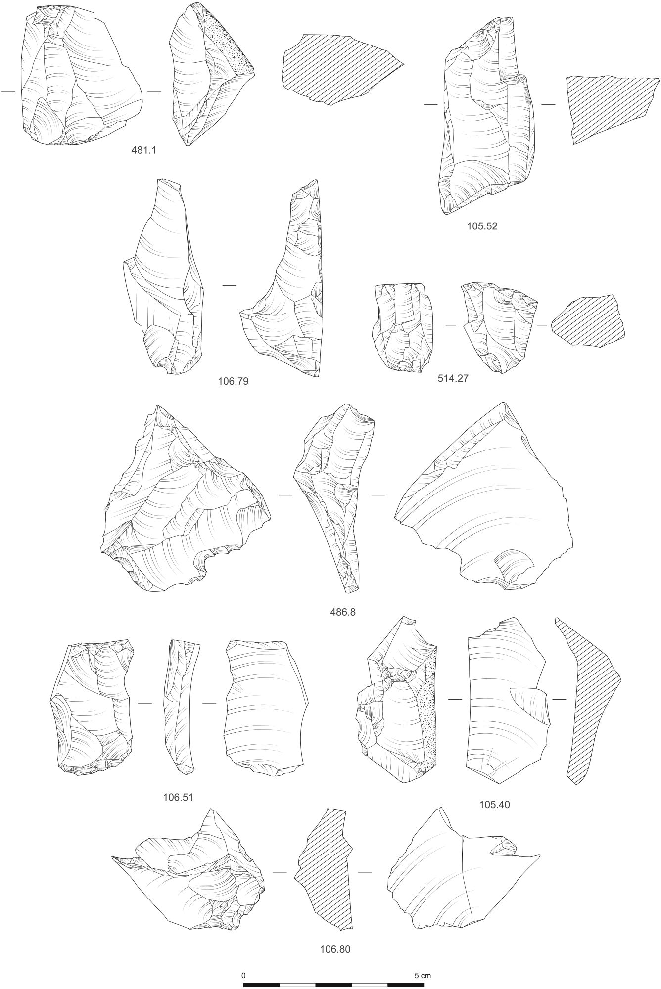
An almost complete core (514.27) (Figure 24) is smaller than the previous two and has been flaked around most of the perimeter to remove blades from two slightly oblique opposed platforms. Step fractures have reduced the length of the blades and the core may have been discarded at this stage.
The four remaining core fragments give little information as to how the tuff was knapped as they are simple fragments with small areas of platform and blade removals.
There are several large core trimming flakes such as 486.8 (Figure 24), which is a large flake detached from an opposite platform of a right-angled platform blade core to remove an irregular platform edge. It is similar in form to core 105.52 (Figure 24). A large platform trimming flake (106.79) (Figure 24) may have been intended as a crested blade but has overshot and removed much of one core face. It had a flat platform, probably formed by breakage along a joint. Other large flakes such as 106.51 (Figure 24) show the use of opposed platform cores.
Other large trimming flakes are not aimed specifically at platform maintenance but instead focus on shaping a blank to a more suitable shape for using as a core by e.g. removing jutting angles (105.40; 106.80) (Figure 16). These are the equivalent of cortical flakes, which are detached to shape the core.
Twenty crested blades were identified, a higher frequency than flint crested blades (Figure 25), indicating that these were an integral part of the strategy for producing the tuff blades.
Many of the platforms are missing or unidentifiable on the flakes and blades but where present they were a mix of broad and narrow flat platforms, occasionally oblique and sometimes crushed. Distinctive lips were visible on 32 blades and eight flakes; although this is normally an indicator of hard hammer use on flint, the fracture dynamics observed with hard hammer might not transfer to a non-siliceous material like tuff. The bulbs were diffuse, which would suggest soft hammer on flint. Platform edge abrasion was absent on the worked tuff.
Blades and flakes were both products of flint and tuff working (Figure 9). A larger proportion of tuff (29%) than flint (12%) was made into blades. In contrast a higher proportion of flint (29%) than tuff (23%) was made into flakes, and in particular the flint assemblage was formed of a higher proportion of small flakes (52%) than tuff (44%). Flakes may be over-represented in flint because of the number of flake fragments and irregular flakes that had been burnt; since all the burnt material was identified as flint, the burnt shatter has skewed the importance of flake fragments. Nevertheless, the larger proportion of small flakes (<10mm in maximum dimension) of flint suggests that the flint might shatter into smaller flakes more readily than the tuff, and also that the flint pebbles had to be more carefully shaped with flake removals prior to detaching the blades. There is less core preparation on the tuff, which could indicate either that some of the tuff nodules were shaped elsewhere before being brought to site, or that the nodules did not require careful preparation of the outer surface prior to detaching the blades.
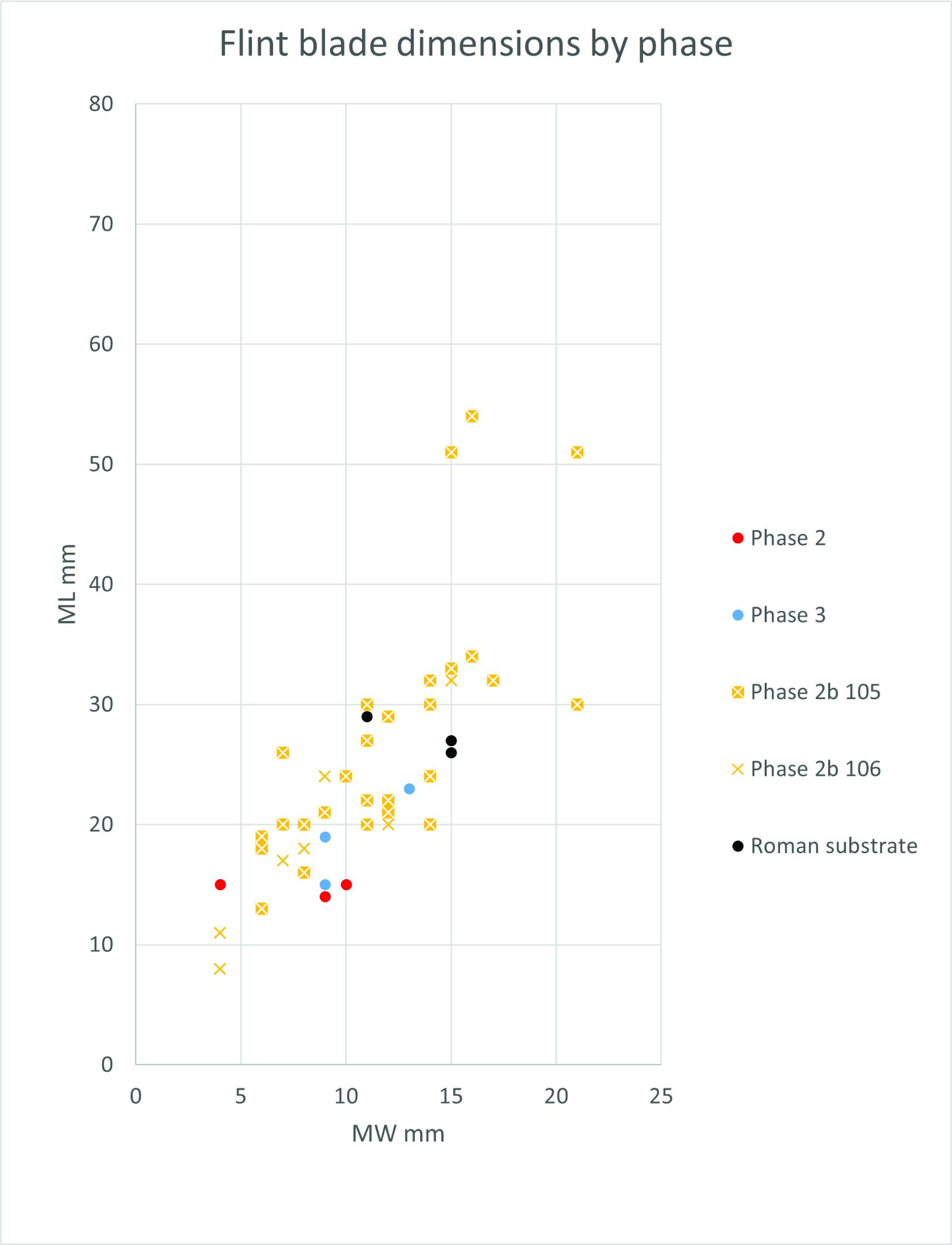
One other main difference between the materials is the smaller size of the flint blades when compared to the tuff (Figure 26, Figure 27). Tuff blades have a wide size range, from 8mm-69mm in length and 4mm-22mm in width, while flint blades concentrate at 8mm to 34mm in length with three outliers of 51mm-54mm in length. The width range of 4mm-21mm is similar to tuff blades but clearly the lengths differ according to material and size of the original nodule.

The blocky, flawed physical nature of chert often causes the stone to split along planes of weakness as it is worked. This means that many cores become quite fragmented, and lose the identifiable features left from specific flaking techniques. The two core fragments (105.47-48) (Figure 28) retain little evidence for how the chert was knapped but a small, remnant flat platform on each indicates some light platform preparation as well as flake and blade removals. The similarities in colour and texture of the two core fragments suggest they were both likely to have been parts from the same larger chert nodule that subsequently split while being worked. There was no other evidence from the chert assemblage as to how the cores were trimmed and reworked, although four small flakes attest to the working of chert on site.
Like the worked flint and tuff, there was a higher proportion of blades than flakes (Figure 9). Although potential geographical sources were identified for the chert (see section 3.1.3) it was not possible to confidently assign all of the chert found on site to a particular area and, consequently, issues of how worked chert from the different sources occurred on site, whether it was knapped in situ or brought in as e.g. finished blades, could not be properly explored.
Two flakes and a blade are the only products of chalcedony working. A core trimming flake (105.328) shows that it was likely worked in a similar manner to pebble flint, with blade removals from simple flat platforms.
One of the two rhyolite flakes has a rolled pebble cortex, indicating it had been detached from a pebble. Neither of the flakes demonstrates any specific core reduction technique.
Thirty-four blades and flakes had been selected for further modification (23 flint; 3.5% of total flint) and 11 tuff (2.2% of total tuff); Table 2). Blade blanks were more commonly selected for retouched tools in both flint and tuff but blades were more frequent in tuff, where 91% of the tools were made from blades compared to flint, 68% of which were made using blades.
| Flint | Tuff | |
|---|---|---|
| Button scrapers | 5 | |
| End scrapers | 2 | |
| Microliths: | 7 | 5 |
| Scalene triangle | 3 | |
| Crescent microlith | 1 | |
| Partially backed microliths | 2 | 3 |
| Microlith fragment | 1 | 2 |
| Backed points | 2 | |
| Obliquely blunted blades | 2 | |
| Knife form | 4 | |
| Edge retouch | 2 | 2 |
| Awls | 2 | |
| Notched blade | 1 |
The five flint button scrapers are made on small flakes, two of which are primary flakes (106.47, 520.1), one a secondary flake (105.240) and the other two inner flakes (105.305, 456.4) (Figure 29). They are of similar sizes (18mm to 20mm in length and 15mm to 18mm in width and 6mm to 14mm in thickness). They all have a short curved scraper edge made around the distal end and have a slight taper on the opposite end, either slightly shaped (105.305; 520.1) or a natural shape (456.4), which was most likely designed to enable the scraper to be hafted. Breakage of 105.305 across the proximal end suggests the flint tool may have snapped in the haft.

The two end scrapers made of tuff are made on blades (Figure 29). A steep scraping edge has been worked around the narrow distal end of (105.123; Figure 17). Heavy abrasion on blade (486.10) has obscured the retouch scars but abrupt edge modification is present down the steeper sides and possibly around the distal end too.
The microliths vary in size and shape and they represent a range of microlithic types (Table 2). Breakage is common among these tools and consequently several cannot be assigned to a specific form.
In flint, small, narrow blade microliths about 5mm in width are the most common form and they are all made of grey/translucent grey flint. Within this group it was possible to identify three scalene triangles, two complete (106.16; Figure 30) and the other with the distinctive triangular end surviving. A crescent microlith (105.262; Figure 30) had a basal fragment missing.
A partially backed blade (105.263; Figure 30) has blunting edge retouch on half of one side from the proximal end whilst another (446.1; Figure 30) is backed down one long edge and also along part of edge at the proximal end. A microlithic fragment, snapped at the proximal end (106.17; Figure 30) bears backing down the length of one side and regular semi-acute edge damage on the opposite edge, most likely from use.

The five tuff microliths are all fragments of worked blades of 6mm to 7mm in width. One (105.264; Figure 30) is a surviving distal tip with abrupt retouch on both sides to shape a point. Three fragments have one partially backed edge where the retouch is confined to about halfway along the edge from either the distal or proximal end (105.122, 106.108 and 486.11; Figure 30). A blade fragment (105.120; Figure 30) has the remains of a curved backed edge.
Two blades, one of white flint and the other of a matt light grey flint (106.109; 106.110; Figure 29), have been backed with steep retouch to form backed blades or possibly backed points.
The first blade (106.109) bears inverse abrupt edge retouch across the squared proximal end and has abrupt edge retouch down the length of one side. A short length of abrupt retouch also survives from the proximal end on the opposite edge. This was subsequently truncated by flaking damage from the distal end. Similar basal retouch or truncation is observed on backed points from Salzkotten-Thüle, a Federmesser-Gruppen site in NW Germany (Heidenreich 2008, fig. 5). At Salzkotten-Thüle several unretouched blades bore damage to the distal end, which was described as impact damage from use as an armature; this is similar to the damage on the distal end of backed blade 106.109 and suggests that it could be a backed point dating to the Federmesser-Gruppen culture of the Final Palaeolithic. The second blade (106.110) is snapped at the proximal end but bears abrupt edge retouch along three-quarters of the length from the distal end while forming a slight curved angle at the distal end. This too bears similarities in size and shape to backed points from Salzkotten-Thüle (Heidenreich 2008). Both blades are of a similar size and are within the average size range noted for backed pieces from Kilmelfort Cave, Argyll, which is 26mm long, 8mm wide and 3mm thick. This cave has an assemblage with typological affinities to Federmesser-Gruppen (Saville and Ballin 2009; see also Section 3.4).
Two tuff blades have been retouched diagonally across the distal end forming a straight edge (105.119) and an irregular edge (105.118; Figure 30).
A fine complete flint blade (105.276; Figure 23) has blunting edge retouch down half of one side from the proximal end and the opposite edge has irregular edge damage from use. Other flint blades have less specific retouch but they may all have been used as some form of knife: one flint blade was retouched abruptly down one side (106.19; Figure 23) while a flint blade segment had similar retouch along a surviving edge as well as edge damage from use on the opposite edge (105.304). Another flint blade had light retouch to form an indented edge with possible edge damage from use on the opposite edge (106.36).
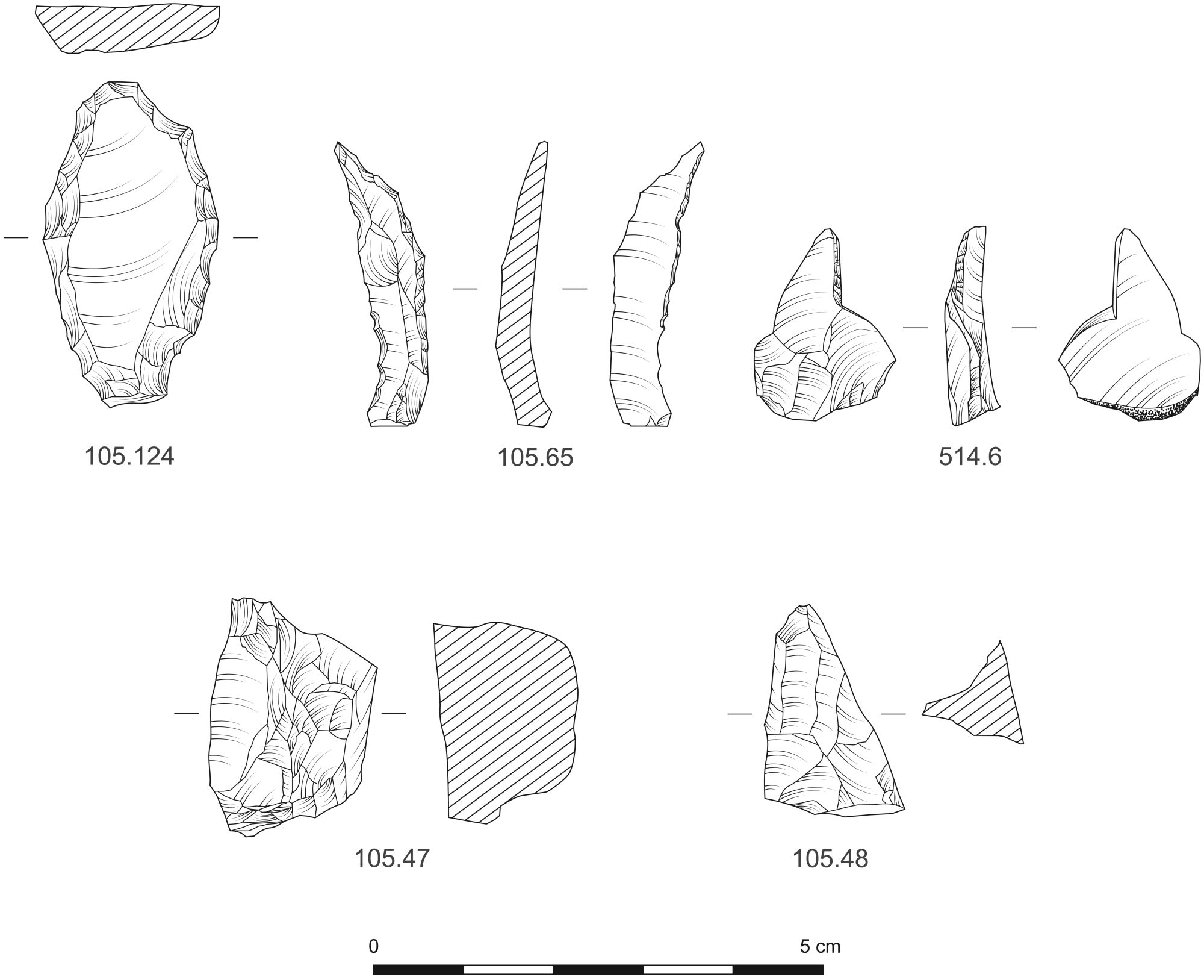
Four of the tools were retouched along the edge to no specific form. Small sections of shallow edge retouch were present on part of the edge of two flint flakes. A tuff flake (462.13; Figure 23) has had sections of the two concave edges enhanced by abrupt retouch, possibly for use as some form of spokeshave or scraper. A short, wide tuff blade (105.124; Figure 28) is heavily abraded and damaged and consequently it is difficult to identify the retouch intention but there is some steep edge retouch around parts of the edges.
A long narrow retouched blade of a distinctive brown flint (105.65; Figure 28) bears abrupt nibbling retouch along one side from the ventral face that forms an irregular outline and a shoulder at the proximal end isolating a point. Similar irregular retouch is located from the proximal end and halfway up the opposite edge. Along this edge semi-acute retouch is worked from the dorsal face to the proximal end. The point at the proximal end is likely to be some form of awl and the obverse retouch designed to allow the point to be rotated more easily.
Another awl (514.6; Figure 28) is made on a flake with cortical platform and has an isolated point on the distal end formed by burin-like removal. Along this flat edge there is removal of regular micro-flakes, probably from twisting in one direction through use as an awl or reamer.
A small notch was made on the proximal end of blade 514.20, possibly to enable hafting.
A fine, elongated hammerstone came from context 106 (106.WS14; Figure 21). Made from a fine-grained quartzitic rock, this waterworn cobble is long and narrow with a thin, flat, cross-section. A spread of an iron-pan concretion is located around one side. This tool has been used for the light hammering of a fine substance that has left spreads of fine pecking, forming slight concavities at both ends on opposite faces.
There is evidence to indicate that the lithic assemblage was formed in at least two distinct periods and this was identified on the basis of reduction strategy, tool typology, blade size and surface alteration to the material (Table 3).
| Evidence source | Final Upper Palaeolithic (Large blade) | Late Mesolithic (Narrow blade) |
|---|---|---|
| Core elements | Large opposed platform blade cores of tuff and mottled blue flint | Pebble flint cores |
| Blade size | Outliers of flint and tuff blades larger than 50mm in length | |
| Debitage | ? | Small flakes and blades |
| Abrasion | The more heavily abraded tuff blades are more likely to be the largest in size | The smallest tuff blades tend to be fresher |
| Retouched tools Blade end scrapers Backed pieces Button scrapers | Narrow blade microliths |
During analysis of the Late Palaeolithic (and later) assemblages from Howburn, Lanarkshire, Ballin identified lithic working characteristics of the Late Hamburgian (12700-12000 BCE) and the slightly later Federmesser-Gruppen (12000-10800 BCE) (Ballin et al. 2018). In summary, the diagnostic elements of Hamburgian flint working comprise decortication, crested blades, large blades from opposed platform cores, soft percussion using en éperon technique, and specific tools such as blade end scrapers, tanged points, burins, Zinken and becs (types of piercing tools) (Ballin et al. 2018). The Federmesser-Gruppen also detached blades using the opposed platform technique with soft percussion, though without faceted platforms, and the retouched tools were characterised by backed blades, many of which were straight-backed pieces (Ballin et al. 2018).
Re-evaluation of the assemblage from Kilmelfort Cave, Argyll (originally identified as Mesolithic) led to its identification as a product of the Curve-Backed Point tradition of the Late Upper Palaeolithic of which the Federmesser-Gruppen is part (Saville and Ballin 2009). The most diagnostic feature was the presence of backed pieces and, because of the clear lack of Hamburgian features (Saville and Ballin 2009, 34), it was believed to be a rare, single-period unmixed assemblage.
The Maryport lithic assemblage is clearly formed from several occupations, and faces similar difficulties to Howburn in determining the extent and nature of earlier lithic working from that which was produced later. Using the diagnostic elements identified by Ballin (above) the Maryport assemblage includes opposed platform working, production of large blades, probable soft hammer technique, and there are two blade end scrapers (105.123 and 486.10; Figure 29) and two straight backed points (106.109 and 106.110; Figure 29). All these elements indicate lithic technology similar to that used by the Federmesser-Gruppen. The button scrapers (105.240, 105.305, 106.47; 456.4; 520.1; Figure 29) found at Maryport may also be used in support of a Federmesser-Gruppen assemblage. Three of the five scrapers from Maryport have similar average dimensions to a group of discoidal and short end scrapers from Kilmelfort Cave (18mm × 18mm × 8mm at Maryport and 15mm × 16mm × 6mm at Kilmelfort Cave), while the other two scrapers are slightly larger. At Howburn a group of similar short end scrapers are larger again, averaging 29mm × 24mm × 9mm, and short end scrapers were more common than blade scrapers in the area of the site determined to be Federmesser-Gruppen. Forms of these small, rounded scrapers are present at most Upper Palaeolithic sites but predominate in Federmesser-Gruppen assemblages across Europe (Saville and Ballin 2009).
At Maryport the earlier assemblage(s) can be identified by the manufacture of broad blades from opposed platform cores, which is organised by detaching guiding crested blades. Both tuff and flint were worked in this manner and the flint selected to be worked in this way is different in colour and texture, and the nodule(s) were larger in size than the local beach pebble flint, suggesting it was brought in to the area from further afield.
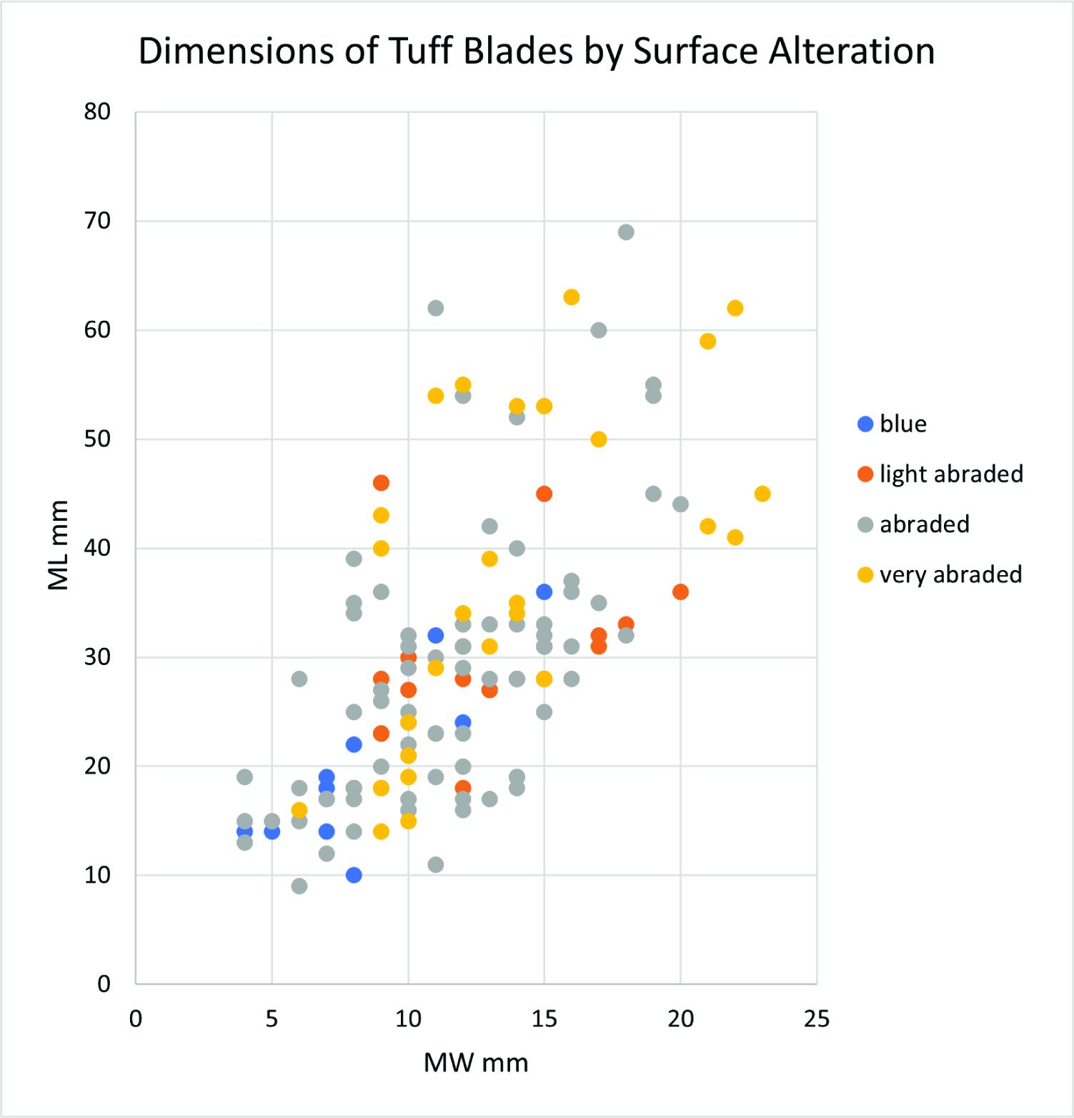
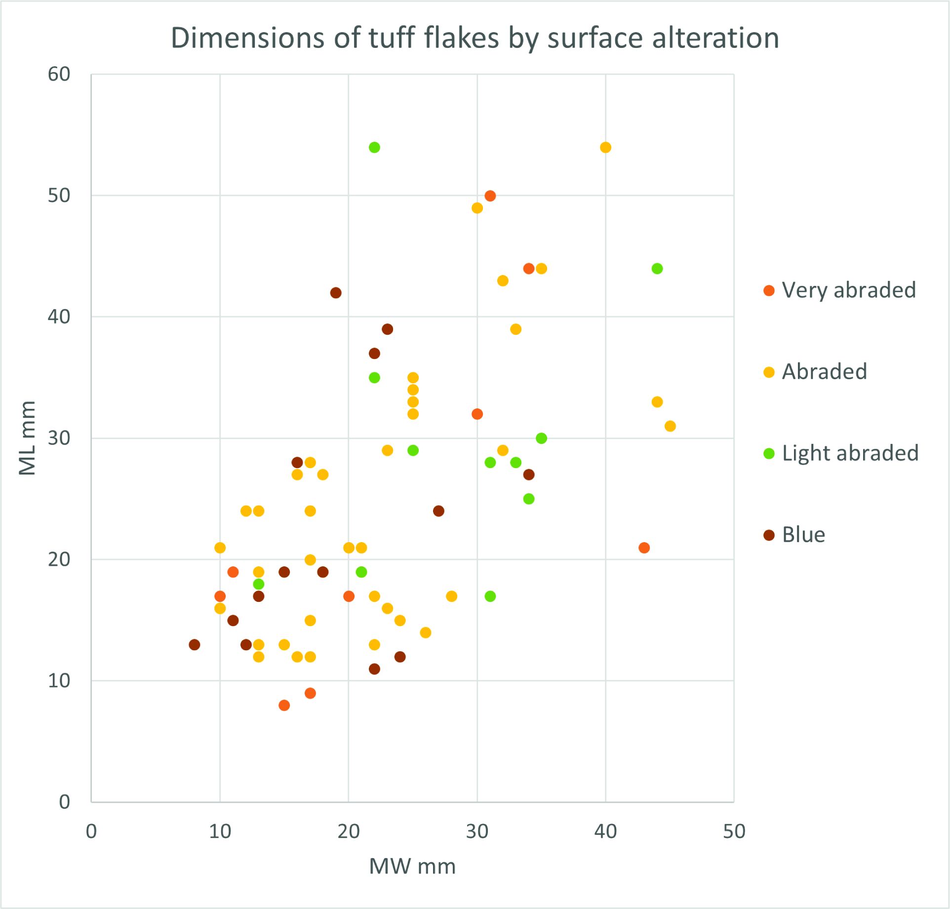
It was not possible to separate the general knapping debris into early and late technologies so the true extent and nature of this earlier occupation cannot be fully estimated but the analysis of the tuff assemblage indicates that the relationship between blade size and the extent of surface alteration could serve to distinguish earlier from later industries. The size distribution of all the complete tuff blades (Figure 31) shows a gap between points at Length >50mm/Width >10mm, and Length >40mm/Width >20mm, forming two groups above and below these dimensions. These size groupings are also observed on the flint blades, where there are three outliers in the larger size range (Figure 26). The tuff blade dimensions were plotted according to the degree of surface alteration and this showed a tendency for the larger blades to be more abraded ('very abraded' and 'abraded' on Fig. 31) than the smaller blades. Also, the smaller blades more frequently retained the original blue colour or were only lightly abraded. For flakes this patterning of size and surface alteration is less clear but the smaller flakes are more likely to be less abraded (Figure 32). This relationship of blade length with surface alteration suggests that the large blades formed an earlier assemblage. The group of three larger flint blades may also be part of this pattern of procurement and use.
The narrow blade assemblage is identified from the single platform blade cores of pebble flint and tuff, narrow blade microliths and numbers of small flakes and blades (Table 3). A group of small flakes and blades of fresher blue tuff are associated with a context (Pit 411) radiocarbon dated to 8200 cal BCE (see Section 5) but for the majority of the narrow blade assemblage there is no specific locus of activity and it is mixed with the earlier lithics, including the Federmesser-Gruppen material.
The majority of the flaked lithics are from layers 105 and 106 and the rest from the cut features (pits) and several of the colluvium layers (Figure 33, Figure 34, Appendix A). The pits contain a greater proportion of small flakes than flakes and blades (Figure 33) and even the blades from the pits are among the smallest of this type across the whole site (Figure 26, Figure 27, Phases 1 and 2). The three cores from the cut features include two small opposed platform blade cores, one of tuff (514.27; Figure 24) and one of flint and a tuff core fragment. Only two retouched tools came from these features, both from 513, and both made of flint including the awl (514.6; Figure 28) and a blade notched at one end.

These cut features were divided into three phases with each being separated by an accumulation of sediment. These produce occupations with only a light footprint of features and tool waste (Figure 35, Figure 36, Figure 37). The main areas of lithic manufacture and other activities were centred on layers 105 and106, which form Phase 2b.
Layers 105 and 106 have the greatest numbers of flaked lithics as regards the context type but 105 has twice the amount than 106 (Figure 35, Figure 36, Figure 37). They both have similar proportions of flint and tuff use with flint being most common. The proportional use of these materials is reversed in the assemblages from the cut features and colluvium (Figure 38) with a large portion made up of small tuff flakes (Figure 35). Flint flakes are more common than blades in both of these layers, but tuff blades are more common in 105 than 106. Chert, banded tuff and chalcedony were also present in small numbers in both layers (Figure 34).
Cores were more common in 105 with the two chert cores, two cores of the same mottled flint, three flint pebble cores, a tuff core with two right-angled platforms and two core fragments, In contrast there were just two single platform blade cores of pebble flint from 106.
There were retouched tools in both layers: equally of flint and tuff in 105 (6 and 7 tools); and in contrast, dominated by flint in 106 (10 of 11 tools). Narrow blade microliths were present in 105 and 106 along with knife forms and scrapers. The two backed pieces are from 106.
Lithics were also found in the colluvium layer above 105 and 106 (Phase 2b), and also those disturbed by Roman activity.


Evidence for early prehistoric activity in the lowland region of Cumbria is scarce and the archaeobotanical finds are a significant discovery for our understanding of subsistence patterns in Northern England at this time. In Scotland research into early prehistoric food strategies has shown widespread use of wild foods such as fruits and nuts throughout the Mesolithic with continuity of these subsistence strategies into the Neolithic period (Bishop et al. 2009), but there remain large gaps in the evidence for parts of Northern England. The environmental samples from Netherhall Road produced large quantities of hazelnut shell, indicating seasonal revisiting an area of valuable natural resources.
The bulk environmental samples were processed using a Siraf-style water flotation system (French 1971). Sample volumes were typically 5–10 litres but there was some variation dependent upon the size of the deposit. The flots were dried before examination under a low-power binocular microscope typically at ×10 magnification. All identified plant remains including charcoal were removed and bagged separately by type.
Wood charcoal was examined using a high powered Vickers M10 metallurgical microscope at magnifications up to ×200. The reference photographs of Schweingruber (1990) were consulted for charcoal identification. Plant nomenclature utilised in the text follows Stace (1997) for all vascular plants apart from cereals, which follow Zohary and Hopf (2000).
The environmental samples taken from the pit features produced large quantities of carbonised plant remains that mainly consisted of hazelnut shell together with fragments of wood charcoal. Condition of the nutshell varied from degraded, highly crushed fragments to very well-preserved half shell pieces up to 10mm in size. Charcoal preservation was generally good. Two samples taken from silty sand deposits (105) and (106) produced ashy charcoal and nutshell fragments, probably indicating a general mixture of hillwash and churned up/mixed burnt remains from activity in the area. Modern material was recorded in low amounts, suggesting a small amount of bioturbation taking place through the deposits.
Fifteen samples were examined from features in use during Phase 1 with substantial quantities of hazelnut shell, occasional fragments of hazel charcoal, but very little else.
Pits 400, 402, 405, 408, 411, 414, 416, 448, 471, 475, 488, 505, 507, 509, and 511 all contained fragments of well-preserved Corylus avellana (hazel) nutshell, with the greatest quantities recorded from 402 and 408. These features were probably seasonal cooking/roasting fire pits or, in the case of some of the shallower features, perhaps small scoop hearths used for the preparation of hazelnuts for food, either for immediate consumption or for storage over winter.
Fuel for these roasting processes was present in 400, 402, 411, 471 and 475, with Corylus (hazel) the main identifiable charcoal present, along with some indeterminate fragments.
Four radiocarbon dates were obtained from hazelnut shell and discussed fully in Section 5.
Sixteen samples from Phase 2 produced consistently large quantities of hazelnut shell per feature with greater amounts recovered overall than from Phase 1, together with a small amount of hazel charcoal. No radiocarbon dates were obtained from samples from these features.
Pits 418, 421, 424, 427, 430, 433, 436, 438, 441, 465, 497, 499, 501 and 503 all contained hazelnut shell, with 441, 497, 501 and 503 producing the greatest volumes.
Irregular feature 444 contained a few fragments of nutshell while 446 overlying this contained a larger deposit of nutshell, perhaps representing remains of a small hearth pit or scrape out of burnt waste remains.
Pits 427, 433, 465, 499, 501 and 503 contained a few fragments of hazel charcoal fuel waste.
Two samples taken from deposits 105 and 106 (Phase 2b), into which the later Roman trackway (004) was constructed, produced very large amounts of hazelnut shell, in particular from 105, consisting of fragments of nutshell as well as lots of highly crushed burnt fragments. Natural colluvial deposit 520 was similar although did not contain as many pieces of nutshell.
Radiocarbon dates from deposits 105 and 106 are discussed in Section 5. These deposits are probably a mixture of sediment formed from hillwash and burnt remains, perhaps soil erosion of pit features higher up the hillside resulting in a general homogenised layer of occupation material.
Three samples were examined from Phase 3. Pits 454, 513 and 454 contained hazelnut shell, with 513 found to contain a substantial deposit of well-preserved fragments. Two radiocarbon dates from pit 513 are discussed in Section 5.
The archaeobotanical evidence obtained from the pit features indicates the intensive seasonal gathering and processing of hazelnuts for food during the Mesolithic period. Roasting of hazelnuts both aids removal of the shell and enhances the flavour of the nut, making them sweeter and more palatable; once sufficiently dry the nut can either be eaten immediately or stored and used as required. The raw nut contains high levels of oil that can become rancid if not processed and stored properly, and it is likely that once roasted the nuts would be kept whole for long-term over-wintering storage purposes rather than made into a paste or bread (Dickson and Dickson 2000, 259).
The pit features produced a small amount of charcoal, which was limited to hazel with some indeterminate fragments also present. This suggested a light open woodland area being seasonally revisited for the practice of harvesting hazelnuts for food, with the hazel wood being burnt as fuel for roasting and cooking purposes. As such, this is probably not fully representative of the types of trees growing in the region during the Mesolithic period and the charcoal remains have been heavily biased by human selection of fuel types.
The environmental samples contained substantial deposits of hazelnut shell radiocarbon dated to the Mesolithic period, indicating processing of hazelnuts for storage and consumption. These were probably significant social events in the yearly calendar and may have involved seasonal gatherings with people returning to the same location for harvesting and other activities. The remains have local and regional significance in the understanding of early prehistoric subsistence patterns in North West England.
In total, ten radiocarbon determinations on charred hazelnut shell were obtained from paired dates from five contexts, which spanned Phases 1, 2b and 3 as determined from stratigraphy (Table 4). The samples were assayed by the Scottish Universities Environmental Research Centre (SUERC) in Glasgow. The radiocarbon dates are quoted to conform to the international Trondheim Convention (Stuiver and Kra 1986). The uncalibrated results (conventional radiocarbon ages; Stuiver and Polach 1977) are given as radiocarbon years before present (BP; AD 1950). Calibration used the maximum intercept method, at one year's resolution (Stuiver and Reimer 1986), using OxCal v4.3.2 (Bronk Ramsey 2009) and the IntCal13 atmospheric calibration curve (Reimer et al. 2013), and the results are reported to 95.4% certainty. Dates were rounded out to five years (Mook 1986). The full complexity of the calendar date-ranges is apparent from the probability distribution of the calibrated dates (Figure 39). The pairs of dates were tested for statistical consistency (Ward and Wilson 1978; Table 5) to see if they were the same age.
| Lab. No. | Context | Phase | Type | Radiocarbon age BP | Calibrated date cal BCE (95% confidence) | Modelled date cal BCE (95% confidence) | δ13C |
|---|---|---|---|---|---|---|---|
| SUERC-88684 | 401 (pit 400) | 1 | Charred hazelnut shell | 9212 ± 24 | 8540-8315 | 8470-8300 | -24.3‰ |
| SUERC-88685 | 401 (pit 400) | 1 | Charred hazelnut shell | 8952 ± 24 | 8260-7980 | 8260-8175 | -22.3‰ |
| SUERC-88686 | 412 (pit 411) | 1 | Charred hazelnut shell | 8966 ± 24 | 8275-7985 | 8255-8210 | -23.4‰ |
| SUERC-88687 | 412 (pit 411) | 1 | Charred hazelnut shell | 8970 ± 24 | 8280-7990 | 8255-8210 | -23.2‰ |
| SUERC-88677 | 105 (layer) | 2b | Charred hazelnut shell | 8863 ± 22 | 8210-7840 | 8200-7950 | -26.4‰ |
| SUERC-88678 | 105 (layer) | 2b | Charred hazelnut shell | 8849 ± 24 | 8200-7830 | 8200-7950 | -26.3‰ |
| SUERC-88679 | 106 (layer) | 2b | Charred hazelnut shell | 8905 ± 23 | 8230-7965 | 8225-7980 | -25.3‰ |
| SUERC-88683 | 106 (layer) | 2b | Charred hazelnut shell | 8823 ± 20 | 8170-7785 | 8200-7830 | -24.3‰ |
| SUERC-88688 | 514 (pit 513) | 3 | Charred hazelnut shell | 9200 ± 24 | 8535-8305 | 8530-8305 | -25.2‰ |
| SUERC-88689 | 514 (pit 513) | 3 | Charred hazelnut shell | 8999 ± 24 | 8285-8220 | 8270-8230 | -28.6‰ |
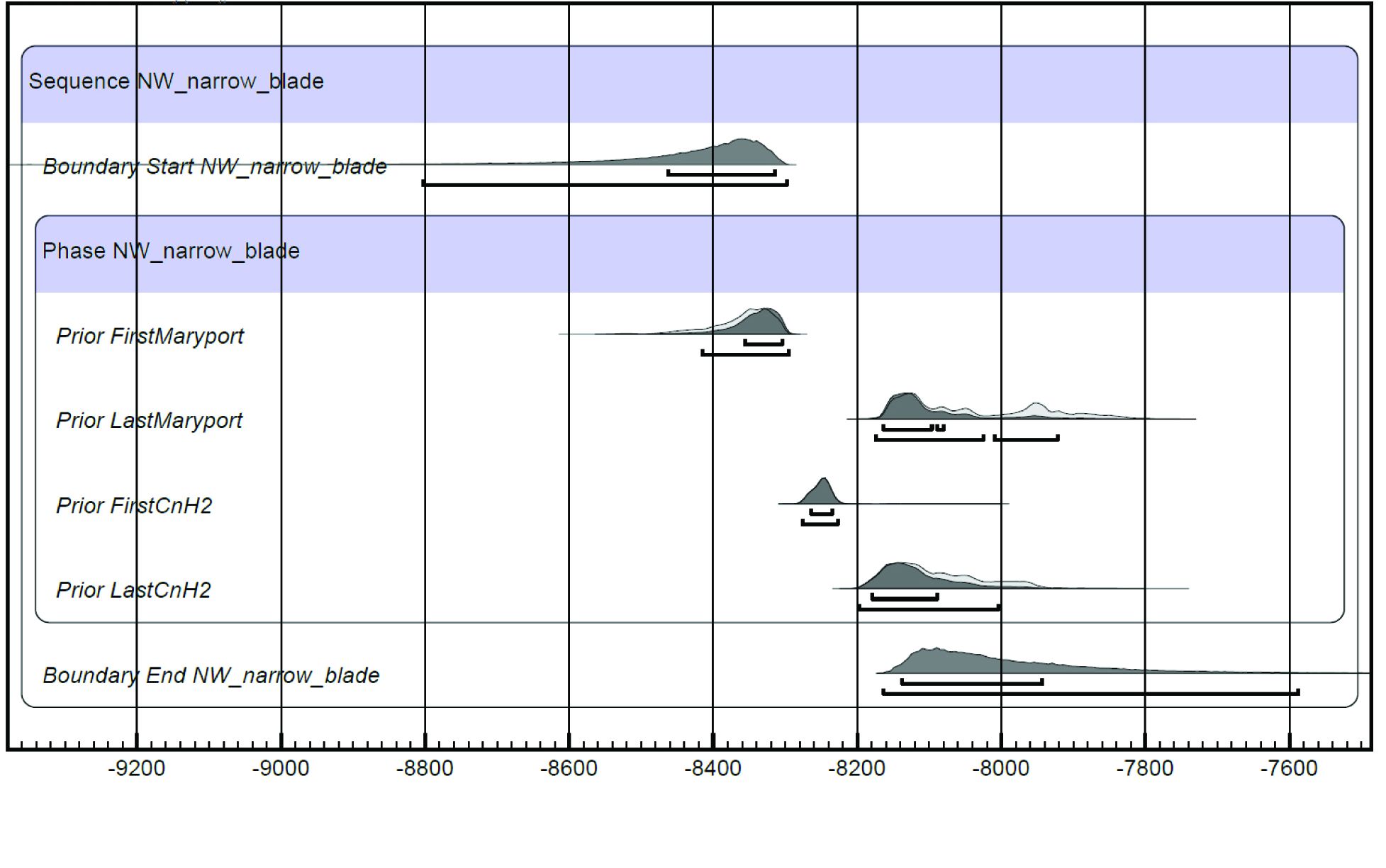
Bayesian modelling of the dates was carried out by Fraser Brown (Oxford Archaeology North) using OxCal v4.3.2. Details of the algorithms employed have been published by Bronk Ramsey (1995; 1998; 2001; 2009). The calibrated radiocarbon dates (Table 4) form the 'standardised likelihoods' component of the model, whereas the archaeology provides the 'prior beliefs'. The modelled radiocarbon dates are reinterpreted according to the archaeological information to provide 'posterior beliefs', which are the outcomes of the dates being modelled (Bayliss et al. 2011, 20). The results of the modelling are illustrated diagrammatically (Figure 39). The light grey/outlines are the calibrated dates/standardised likelihoods and the darker grey areas are those that are statistically more probable when calculated against the other dates in the model. The posterior density estimates/modelled dates are conventionally italicised, to distinguish them from simple calibrated radiocarbon dates, which are set out in standard text.
| Feature | Radiocarbon date | OxCal Combine function chi-squared test | Combined date (95.4%) |
|---|---|---|---|
| Pit 400 | SUERC-88684 SUERC-88685 | df=1 T=43.089(5% 3.8) Acomb= 0.0% | N/A failed |
| Pit 411 | SUERC-88686 SUERC-88687 | df=1 T=0.00(5% 3.8) Acomb=159.9% | 8260-8210 cal BCE |
| Layer 105 | SUERC-88677 SUERC-88678 | df=1 T=0.033(5% 3.8) Acomb=129 | 8200-7940 cal BCE |
| Layer 106 | SUERC-88679 SUERC-88683 | df=1 T=4.377(5% 3.8) Acomb= 36.9% | N/A failed |
| Pit 513 | SUERC-88688 SUERC-88689 | df=1 T=25.905(5% 3.8) Acomb= 0.4% | N/A failed |
Reflecting the stratigraphy, the model comprises a sequence of three discrete successive phases (1, 2b and 3; Table 4; Figure 39). The duration of the radiocarbon-dated occupation spans 150 to 558 years at 95.4% probability (Figure 40), commencing 8470-8300 cal BCE (First_Maryport) and finishing 8170-7835 cal BCE (Last_Maryport).
Of the four radiocarbon dates from Phase 1, two (pit 411) were statistically consistent and were combined; the resultant 'prior' being used in the model. The dates from pit 400 failed a chi-squared test. Although SUERC-88685 was similar in age to the combined date for pit 411, SUERC-88684 was much older, possibly being a residual hazelnut from an earlier phase of activity at the site. The radiocarbon dating agrees with the stratigraphy, in suggesting that the Phase 1 pits were earlier than the deposits that sealed them, probably dating to around c. 8200 cal BCE or just before.
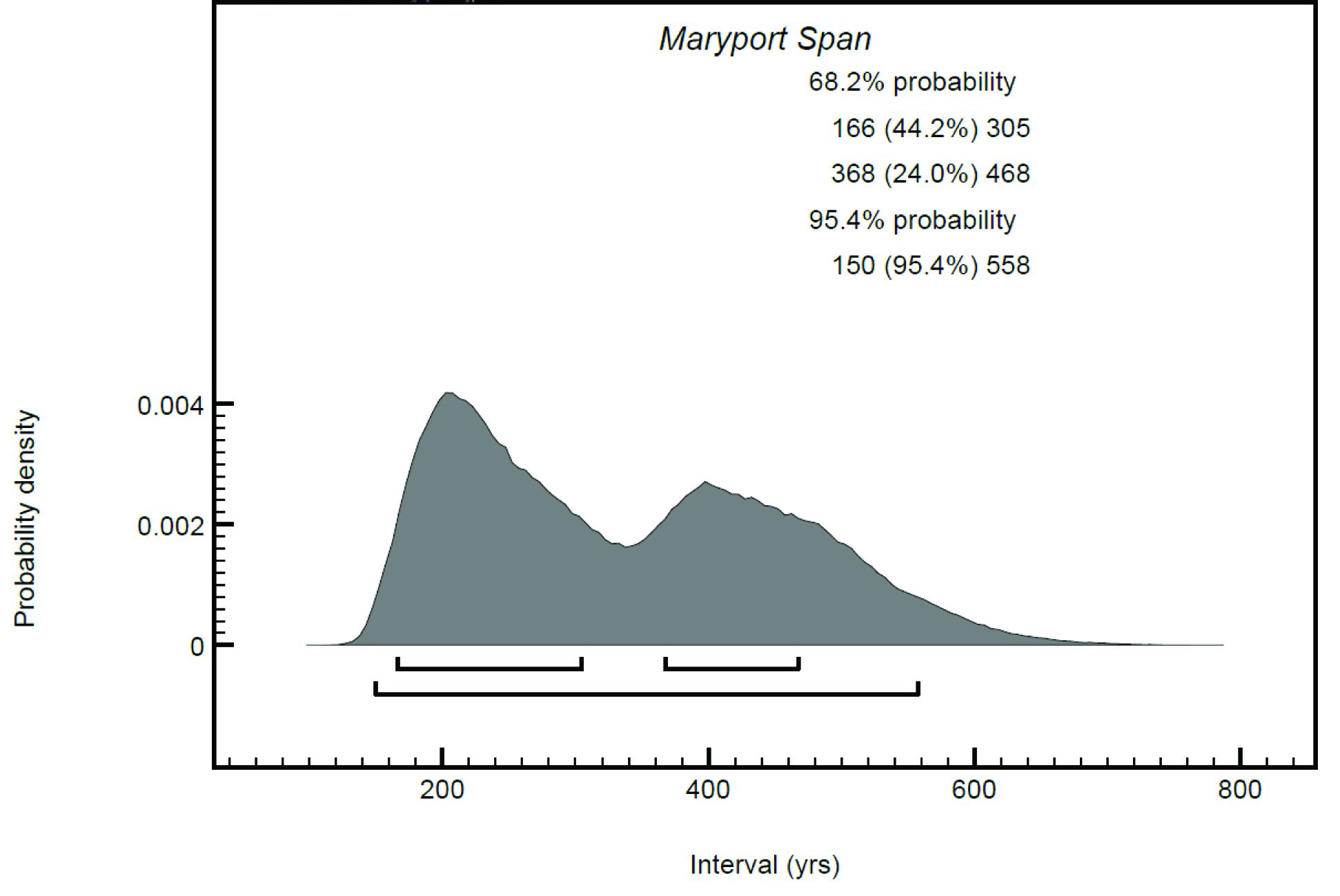
The dates from Phase 2 seem to be slightly later, again in accordance with the stratigraphy. The two dates from layer 105 were combined in the model, being statistically consistent, whereas the dates from layer 106 failed a chi-squared test. Overall, however, the dates were broadly comparable with each other and could reflect a phase of activity between c. 8200-8100 cal BCE, or possibly slightly later (the calibration curve plateaus at this point, smearing out the distributions, so the dates may appear to be later than the activity actually was).
The two dates from Phase 3 (pit 513) failed a chi-squared test and are of different ages. SUERC-88688 is the earliest, being of similar age to the aforementioned SUERC-88684, and is, likewise, also probably residual, whereas SUERC-88689 is of similar age to the material from Phase 1 pit 411: as such, if the observed stratigraphy is correct, it also probably does not date the backfilling of pit 513 but is instead also residual. Owing to this, these dates have been entered into the model as termini post quos, using the 'After' function in OxCal.
There are clearly some complexities to the taphonomy of the site, and in certain features (e.g. Pit 401, Phase 1 and Pit 513, Phase 3) the assemblages are possibly mixed. Conversely, the pair of similar dates from Pit 411, together with the accompanying assemblage of small-sized debitage of unabraded tuff, probably indicates that this feature was rapidly filled with nutshell and lithics from activity in the immediate area. The Phase 2b dates are from the largest layers 105 and 106, which contain broad blade and narrow blade lithic artefacts, as well as identified Final Palaeolithic tools (Section 3.4). The lithics included in these deposits were deposited over a considerable length of time and derive from different occupations. Given that they partially seal Phase 1 deposits, they are clearly redeposited. The consistency of the dates from Phase 2b (Figure 39), however, suggests that despite the chronological mix of flaked lithics, the processing of hazelnuts was limited to a short length of time in the use of the site.
Throughout the occupations of the site, from the Final Palaeolithic (12,000-10,800 BCE dated by lithic typology; Section 3) to the radiocarbon-dated occupations around c. 8200 cal BCE, the environment would have been adjusting to the recent deglaciation of the region and the consequent rapid changes in sea level and the extent and type of vegetation cover. There have been no investigations of the changes in relative sea levels (RSL) during the Early Holocene around the immediate Maryport area, though sea levels of the south Solway coast and Morecambe Bay have been modelled (Lloyd et al. 1999; Stone et al. 2010) and there is closer dating of litho- and bio-stratigraphical data from the Ravenglass Estuary (Lloyd et al 2013). Changes in sea level were not uniform around the Cumbrian coast and this, together with the lack of agreement between the various studies regarding sea level heights at different times, particularly where the RSL is estimated rather than measured, means that there are no specific measurements for the height and dating of sea levels at Maryport and it is not clear whether the information from the diverse sea level curves can be extrapolated to this location. The various models, however, agree on the rapid rise of sea level between the Early and Mid-Holocene. Around the Ravenglass estuary, some 50km to the south of Maryport, the minimum age of deglaciation is around 14,800 cal BCE, with consequent eustatic and isostatic changes during the early Holocene creating a rapid rise in sea level from -5m OD to a maximum stand of c. 1m OD at c. 3000-5000 cal BCE (Lloyd et al. 2013, 69). At the very least, the coastline at the point of the radiocarbon-dated occupation at Maryport can be estimated to be c. 1km from the present location, forming a flat coastal plain (Wickham-Jones pers. comm.) and the River Ellen would have formed a delta out over this flat coastal strip. The sea level would have been even lower at the beginning of the Holocene, the earliest identified use of the site, and the steady incursion of the sea over the next five thousand years to the mid-Holocene would have gradually brought the coastline to the edges of the sandstone cliffs and made the latter stretches of the river a more saline environment.
The vegetation cover in the region would have gradually developed from alpine herbaceous vegetation at c. 10,000 BCE to juniper, birch, willow, then pine and hazel. Pollen evidence from sediments at Howburn, Lanarkshire, demonstrate the rise of birch and juniper at around 9750 BCE while hazel is barely present in the record at this time (Ballin et al. 2018). Hazel became firmly established around the Irish sea coasts by 8000 BCE, possibly helped by human movements around the region (Stone et al. 2010). The charcoal evidence from the site (Section 4) indicated a highly selective assemblage formed mainly of hazel wood and nutshell and the intensive processing of this food resource. This implies that the gathering of this seasonal resource was highly organised, socially, temporally, and spatially across the landscape. Conneller (2021) discusses the intensive exploitation of hazelnuts across Britain during the Middle Mesolithic 8200–7000 BCE. In the north-west of England intensive hazelnut processing is less well recognised, though recently it was also recorded at Cass ny Hawin 2 on the Isle of Man. Here, a burnt structure with occupation of a similar date to that radiocarbon dated at Maryport (Brown et al. in press b and Section 7) had evidence for in situ deposits including hammerstones and anvils, which may have been used to process the charred nuts (Brown et al. in press b). At Maryport only one cobble tool was recorded but this was not directly associated with the charred nutshell.
Perched on a narrow terrace on the side of a steep-sided valley 9m above the present-day floodplain of the River Ellen, with a hill rising behind to 56m aOD, this was not the location for an extensive settlement. Repeated visits to the spot are attested by the pits that were made on at least three occasions, each time cutting into the recent colluvium accumulated from hillwash. The radiocarbon dating indicates that these were dug over 10,000 years ago at around 8200 cal BCE. The lithic evidence also demonstrates the site was occupied as early as the Final Palaeolithic, though no associated features or loci of activity dating to this period were identified during excavation.
The majority of the lithic assemblage came from contexts 105 (43%) and 106 (21%) but interpretation of how these layers accumulated is complicated by the nature of the colluvium deposits, which at times appear to be separate and in other places interleaving and mixed. Aldritt (Section 4) suggests that layers 105 and 106 represent sediment formed from hillwash and burnt remains derived from the soil erosion of pit features higher up the hillside, which resulted in a general homogenised layer of occupation material. Some of the flaked lithics found in these layers may have accumulated from this hillwash, being brought down from locations further up slope. However, it might be expected that the later Roman disturbance in the area above the site would unearth some evidence for this proposed early prehistoric occupation, but there was scant evidence for flaked lithics during these excavations.
It is proposed here that layers 105 and 106 were formed directly from a series of occupations spanning the Final Palaeolithic to later Mesolithic. Sections from the excavations (Figure 4) suggest that these layers may have originally formed in features that were cut into the slope to form working platforms, though this was not observed in plan during excavation. Evidence from the stone tools supports the suggestion that 105 and 106 were formed of some in situ occupation: the elongated hammerstone in 106 is more likely to have been used in the vicinity rather than having moved downhill within hillwash, and the group of five mottled blue flint pieces (105.299-303) from 105, which probably come from the same nodule and have been worked using the same technique of opposed platform blade working, demonstrates in situ working or at least a single deposition of knapping waste. In between occupations these layers were subjected to erosion and created colluvial deposits overlying and interleaving with later Mesolithic cut features. However, the lack of 3D recording of the finds means that there is no distribution data with which to support or reject this theory.
The varied tool kit, including microliths of various types, scrapers, knife forms and an awl as well as blades and flakes, would have accumulated over the periods of occupation. Most of these retouched tools are from 105 and 106 and demonstrate that a range of activities was carried out involving the processing of materials, e.g. scraping, cutting and piercing. The microliths could represent armatures or plant processing. There is no evidence that this was a specialist site such as a hunting stand, though the two Federmesser-Gruppen backed points might indicate the use of armatures while the accompanying scrapers demonstrate the preparation of animal hides. The location could have been used for different purposes over the periods of occupation. There is clear use of the terrace for processing and/or storage of hazelnuts around 8200 cal BCE when the slope might have provided a convenient area of dry land away from the changing river courses on the floodplain. Alldritt (Section 4) suggested some of the pits, e.g. 402 and 408 from Phase 1, were seasonal roasting fire pits, or in the case of some of the shallower features perhaps small scoop hearths used for the preparation of hazelnuts for food, either for immediate consumption or for prolonging their storage over winter.
Tuff is widely known as the stone quarried during the Neolithic at Great Langdale, Cumbria, and these outcrops forming the Group VI axe factory were the primary sources of Neolithic axe production. Much work on excavating the individual quarried outcrops and sourcing the rock to particular quarried outcrops has been carried out over the years, along with identifying the manufacturing techniques of the stone axeheads made of Langdale tuff as well as, of course, identifying the pattern and mechanics of the distribution of these axes across Britain (Bradley and Edmonds 1993).
There is accumulating evidence for the use of tuff prior to the Neolithic. The extensive field-walking campaigns throughout Cumbria by Cherry and Cherry have identified several assemblages of worked tuff: notably St Bees III and IV and Rottington V along with larger flint assemblages (Cherry and Cherry 1983; 1987). At these Mesolithic sites, the tuff was collected as rounded pebbles and then worked down from cores into blades, flakes and microliths.
Cobbles and pebbles of tuff were also collected from gravel sources and brought to Stainton West, Carlisle, where excavations by Oxford Archaeology North have recovered a large flaked lithic assemblage of flint and chert with some pitchstone and tuff. The site is mainly Late Mesolithic with Neolithic and Bronze Age elements. The tuff was flaked into blades and microliths including backed blades, scalene triangles, fine points, and crescents (Brown et al. in press a).
The use of tuff cobbles for flake tools is clearly recognised in the archaeological record but up until the discovery of the Maryport site the potential for Mesolithic (and earlier) exploitation of the original tuff outcrops had not been recognised.
'The source for lithic forms manufactured from volcanic tuff in the north of the region is still believed to be glacial drift originating from the central Cumbrian Massif (Bradley and Edmonds 1993). There is as yet no evidence that the high quality material in the central Lakes was exploited at source until the Early Neolithic (Bradley and Edmonds 1993).' (Hodgson and Brennand 2006, 27).
The worked tuff from Maryport has been identified macroscopically as high-quality material, probably from the central Lake District around Langdale (David Millward pers comm). The finer points of how the tuff was acquired, whether by the direct quarrying of the outcrops or by collecting blocks from the fresh scree, is yet to be ascertained. What is clear is that the tuff was exploited directly at source probably as early as the Final Palaeolithic and continued to be collected from the same area during the Mesolithic around 8200 cal BCE.
There is the potential for the geological sourcing of the Maryport material, perhaps even being able to pinpoint the exact outcrop source from which it derived, by using the data collected for the Group VI axe work. However, there will be several issues to be addressed in work of this type:
Maryport is a valuable addition to the early prehistory of Cumbria and the north of Britain in general. The evidence from the lithics points to an early occupation dating to the Final Palaeolithic (Federmesser-Gruppen) and it is also the first identified open-air site of this date in the region, as previous evidence for activity during this early period comes from a series of unpublished cave sites. Recent field walking in the limestone uplands of eastern Cumbria has turned up flint artefacts of a probable Final Palaeolithic date (Cherry and Dickson pers. comm.), which would also indicate the presence of open-air sites of this period located further inland. There is an (unconfirmed) Federmesser-Gruppen point from a cave site near Kent's Bank Cavern (Hodgson and Brennand 2006).
There are references in the literature to Early Mesolithic activity in Cumbria but none are directly supported by publication. According to the Prehistoric Assessment (Hodgson and Brennand 2006) there are finds of Early Mesolithic date from investigations in caves in the region. At Bart's Shelter there were reported Early Mesolithic microliths, some of volcanic tuff, but dates from an antler/bone point of 6210-6190 cal BCE do not match the typological identification of the microliths (Hodgson and Brennand 2006, 25). There is also reference to Early Mesolithic human remains from Kent's Bank Cavern.
Maryport is also the first excavated Mesolithic site in Cumbria to have such an early secure date of 8200 cal BCE. The closest comparable site is found not far across the Irish Sea on the Isle of Man where the recently excavated Mesolithic structure at Cass ny Hawin 2, Ronaldsway, on the southern tip of the island has radiocarbon dates and an occupation range almost identical to those at Maryport (Brown et al. in press b, Figure 41). The lithic assemblage from Cass ny Hawin 2 was similar to the narrow blade assemblage at Maryport, based on blade working of pebble flint and narrow blade microliths. Large quantities of charred hazelnut shell were found within the structure and 100% sampling of its interior produced an assemblage of 10,238 shell fragments weighing 170g (Oxford Archaeology n.d.). The quantities of nutshell are similar to the total amount found at Maryport, with 13,986 fragments weighing 153g. The greatest amounts of nutshell from Maryport came from layers 105 and 106; however, these were just from processed samples – not 100% collection – and so the original quantities of charred hazelnuts would likely have been much greater than that found at Cass ny Hawin 2.
Understanding of the use of the wider landscape from the Final Palaeolithic and throughout the Mesolithic is enhanced by the knowledge that tuff was exploited for tools at source among the peaks of the Central Lake District, and that blocks of the material were carried to a bluff above a river, close to the flat coastal plain to be worked into tools. Final Palaeolithic groups such as the Federmesser-Gruppen commonly sought out rock that was locally available: e.g. at Howburn, Lanarkshire, the use of local chert dominated the worked lithic assemblage that had typological affinities to Federmesser-Gruppen (Ballin et al. 2018), whilst at Kilmelfort Cave, Argyll, quartz supplemented the use of flint (Saville and Ballin 2009). Knowledge and observation of the various rock sources would have been enabled by the sparse vegetation cover at the end of the Late Glacial, which would have exposed outcrops of frost-shattered material to be examined for suitability and exploited as the groups travelled through the landscape.
Find spots of typologically Federmesser-Gruppen diagnostic pieces across Britain are listed by Saville in the Kilmelfort article (Saville and Ballin 2009, 35) and he noted the dominance of cave sites; however, there appear to be more records of open-air Federmesser-Gruppen sites in the south and east of Britain (Ashton 2017, 267). In the north-west of Britain the recent discoveries at Howburn, and Maryport, both of which are open-air sites sitting on raised terraces overlooking a stream/river floodplain/marsh area, are expanding the known range of landscape niches that were exploited at this time.
The period dating from the last retreat of the glaciers to the mid-Holocene is little understood, particularly in the north and west of Britain, and until recently the lack of sites dating to the Final Palaeolithic and Early Mesolithic has implied there was no occupation in the area until the Late Mesolithic. Archaeologists are now beginning to recognise that the landscape was exploited at this period and in a different manner from that of the Late Mesolithic. Evidence from Maryport suggests that stone (in this case tuff) was quarried or extracted from an outcrop source during the Final Palaeolithic and this points to inland journeys across high land. In contrast, the region has evidence that tuff cobbles were exploited for use during the later Mesolithic. These were collected from gravel drift deposits, on coasts, in river exposures or scars in the landscape. This could be a response to the increased vegetation over the landscape altering hunting and gathering habits and changing the journey routes and distances made across the land.
B - Blade; RF - Regular flake; FF/IF - Flake fragment/Irregular flake; SF - Small flake; Core - Cores and flaked/unflaked pebbles; Ret - Retouched tools; Chunk - Chunks.
Phase 1 Phase 2 Phase 2b Phase 3 Mixed Roman Final silts over 105, 106 Silt sealing phase 1 Natural gully
| B | RF | FF/IF | SF | Core/pebble | Ret | Chunk | TOTAL | |
|---|---|---|---|---|---|---|---|---|
| 105 | 3 | 3 | 2 | 0 | 2 | 0 | 0 | 10 |
| 106 | 1 | 0 | 0 | 0 | 0 | 0 | 0 | 1 |
| 405 | 2 | 0 | 0 | 0 | 0 | 0 | 0 | 2 |
| 497 | 0 | 0 | 0 | 1 | 0 | 0 | 0 | 1 |
| 514 | 1 | 1 | 0 | 3 | 0 | 0 | 0 | 5 |
| 520 | 2 | 0 | 0 | 0 | 0 | 0 | 0 | 2 |
| Total | 9 | 4 | 2 | 4 | 2 | 0 | 0 | 21 |
| B | RF | FF/IF | SF | Core/pebble | Ret | Chunk | TOTAL | |
|---|---|---|---|---|---|---|---|---|
| 105 | 1 | 2 | 1 | 2 | 0 | 0 | 0 | 6 |
| 106 | 0 | 2 | 0 | 0 | 0 | 0 | 0 | 2 |
| 456 | 2 | 0 | 0 | 0 | 0 | 0 | 0 | 2 |
| 486 | 1 | 0 | 0 | 0 | 0 | 0 | 0 | 1 |
| 502 | 0 | 0 | 0 | 1 | 0 | 0 | 0 | 1 |
| Total | 4 | 4 | 1 | 3 | 0 | 0 | 0 | 12 |
| B | RF | FF/IF | SF | Core/pebble | Ret | Chunk | TOTAL | |
|---|---|---|---|---|---|---|---|---|
| 514 | 0 | 0 | 2 | 0 | 0 | 0 | 0 | 2 |
| Total | 0 | 0 | 2 | 0 | 0 | 0 | 0 | 2 |
| B | RF | FF/IF | SF | Core/pebble | Ret | Chunk | TOTAL | |
|---|---|---|---|---|---|---|---|---|
| 105 | 0 | 2 | 0 | 0 | 0 | 0 | 0 | 2 |
| 106 | 1 | 0 | 0 | 0 | 0 | 0 | 0 | 1 |
| 1Total | 2 | 0 | 0 | 0 | 0 | 0 | 3 |
| Cut | Ctxt | B | RF | FF/IF/spalls | SF | Core/ pebble | Ret | Chunk | TOTAL |
|---|---|---|---|---|---|---|---|---|---|
| 105 | 45 | 37 | 75 | 163 | 7 | 7 | 5 | 339 | |
| 106 | 14 | 9 | 49 | 72 | 2 | 10 | 6 | 162 | |
| 400 | 401 | 1 | 0 | 0 | 0 | 0 | 0 | 0 | 1 |
| 402 | 403 | 0 | 0 | 1 | 0 | 0 | 0 | 0 | 1 |
| 408 | 409 | 0 | 1 | 0 | 1 | 0 | 0 | 0 | 2 |
| 411 | 412 | 0 | 1 | 0 | 1 | 0 | 0 | 0 | 2 |
| 418 | 419 | 0 | 0 | 0 | 3 | 0 | 0 | 0 | 3 |
| 424 | 425 | 0 | 0 | 0 | 5 | 0 | 0 | 0 | 5 |
| 427 | 428 | 0 | 0 | 0 | 2 | 0 | 0 | 0 | 2 |
| 430 | 431 | 0 | 0 | 0 | 3 | 0 | 0 | 0 | 3 |
| 438 | 439 | 0 | 1 | 0 | 0 | 0 | 0 | 0 | 1 |
| 441 | 442 | 0 | 0 | 0 | 10 | 0 | 0 | 0 | 10 |
| 444 | 445 | 0 | 0 | 0 | 0 | 0 | 0 | 0 | 0 |
| 448 | 449 | 0 | 0 | 0 | 1 | 0 | 0 | 0 | 1 |
| 454 | 455 | 0 | 0 | 0 | 4 | 0 | 0 | 0 | 4 |
| 465 | 466 | 0 | 0 | 0 | 1 | 0 | 0 | 0 | 1 |
| 471 | 472 | 0 | 0 | 0 | 1 | 0 | 0 | 0 | 1 |
| 482 | 483 | 0 | 0 | 1 | 0 | 0 | 0 | 0 | 1 |
| 484 | 485 | 1 | 0 | 0 | 0 | 0 | 0 | 0 | 1 |
| 497 | 498 | 1 | 0 | 0 | 7 | 0 | 0 | 0 | 8 |
| 499 | 500 | 0 | 0 | 0 | 0 | 0 | 0 | 1 | 1 |
| 501 | 502 | 2 | 0 | 2 | 7 | 1 | 0 | 0 | 12 |
| 503 | 504 | 0 | 0 | 0 | 3 | 0 | 0 | 0 | 3 |
| 505 | 506 | 0 | 0 | 0 | 5 | 0 | 0 | 0 | 5 |
| 509 | 510 | 0 | 0 | 0 | 1 | 0 | 0 | 0 | 1 |
| 513 | 514 | 4 | 5 | 0 | 34 | 0 | 2 | 0 | 45 |
| coll | 520 | 1 | 2 | 0 | 7 | 0 | 1 | 0 | 11 |
| silt | 446 | 0 | 0 | 0 | 0 | 0 | 1 | 0 | 1 |
| silt | 447 | 0 | 0 | 1 | 3 | 0 | 0 | 0 | 4 |
| coll | 456 | 1 | 1 | 0 | 0 | 1 | 2 | 0 | 5 |
| coll | 459 | 0 | 0 | 0 | 0 | 0 | 0 | 0 | 0 |
| coll | 461 | 0 | 0 | 0 | 0 | 0 | 0 | 0 | 0 |
| coll | 462 | 4 | 0 | 0 | 0 | 0 | 0 | 0 | 4 |
| void | 481 | 0 | 0 | 0 | 0 | 0 | 0 | 0 | 0 |
| 460 | 486 | 0 | 2 | 0 | 0 | 0 | 0 | 0 | 2 |
| us | 1 | 2 | 0 | 0 | 0 | 0 | 1 | 4 | |
| Total | 75 | 61 | 129 | 334 | 11 | 23 | 13 | 646 |
| Cut | Ctxt | B | RF | FF/IF | SF | Core | Ret | Chunk | TOTAL |
|---|---|---|---|---|---|---|---|---|---|
| 105 | 63 | 27 | 17 | 32 | 3 | 7 | 0 | 149 | |
| 106 | 29 | 22 | 5 | 18 | 0 | 1 | 1 | 76 | |
| 400 | 401 | 6 | 0 | 1 | 28 | 1 | 0 | 0 | 36 |
| 402 | 403 | 1 | 0 | 1 | 0 | 0 | 0 | 0 | 2 |
| 408 | 409 | 0 | 1 | 1 | 1 | 0 | 0 | 0 | 3 |
| 411 | 412 | 6 | 8 | 5 | 41 | 0 | 0 | 1 | 61 |
| 418 | 419 | 0 | 0 | 0 | 0 | 0 | 0 | 0 | 0 |
| 424 | 425 | 0 | 0 | 0 | 5 | 0 | 0 | 0 | 5 |
| 427 | 428 | 1 | 0 | 0 | 1 | 0 | 0 | 0 | 2 |
| 430 | 431 | 1 | 1 | 0 | 3 | 0 | 0 | 0 | 5 |
| 438 | 439 | 0 | 0 | 1 | 0 | 0 | 0 | 0 | 1 |
| 441 | 442 | 0 | 0 | 0 | 0 | 0 | 0 | 0 | 0 |
| 444 | 445 | 0 | 0 | 0 | 1 | 0 | 0 | 0 | 1 |
| 448 | 449 | 0 | 0 | 0 | 0 | 0 | 0 | 0 | 0 |
| 454 | 455 | 1 | 0 | 1 | 0 | 0 | 0 | 0 | 2 |
| 465 | 466 | 0 | 0 | 0 | 3 | 0 | 0 | 0 | 3 |
| 471 | 472 | 0 | 0 | 0 | 1 | 0 | 0 | 0 | 1 |
| 482 | 483 | 0 | 1 | 0 | 0 | 0 | 0 | 0 | 1 |
| 497 | 498 | 0 | 0 | 0 | 1 | 0 | 0 | 0 | 1 |
| 499 | 500 | 0 | 0 | 0 | 0 | 0 | 0 | 0 | 0 |
| 501 | 502 | 0 | 1 | 0 | 3 | 0 | 0 | 0 | 4 |
| 503 | 504 | 0 | 0 | 0 | 2 | 0 | 0 | 0 | 2 |
| 505 | 506 | 0 | 0 | 0 | 5 | 0 | 0 | 0 | 5 |
| 509 | 510 | 0 | 0 | 0 | 0 | 0 | 0 | 0 | 0 |
| 513 | 514 | 14 | 2 | 0 | 44 | 1 | 0 | 1 | 62 |
| coll | 520 | 1 | 2 | 2 | 21 | 0 | 0 | 0 | 26 |
| silt | 446 | 0 | 0 | 0 | 3 | 0 | 0 | 0 | 3 |
| silt | 447 | 0 | 0 | 0 | 3 | 0 | 0 | 0 | 3 |
| coll | 456 | 8 | 1 | 1 | 0 | 0 | 0 | 0 | 10 |
| coll | 459 | 0 | 2 | 0 | 0 | 0 | 0 | 0 | 2 |
| coll | 461 | 4 | 0 | 0 | 1 | 0 | 0 | 0 | 5 |
| coll | 462 | 4 | 3 | 2 | 0 | 0 | 1 | 0 | 10 |
| void | 481 | 0 | 0 | 0 | 0 | 1 | 0 | 1 | |
| 460 | 486 | 5 | 1 | 0 | 0 | 0 | 2 | 0 | 8 |
| us | 2 | 0 | 0 | 0 | 0 | 0 | 0 | 2 | |
| Total | 146 | 72 | 37 | 217 | 6 | 11 | 3 | 492 | |
Pebbles – Complete or split flint pebbles.
Cores – Artefacts from which a sequence of removals has been taken. They have been classified into the following types:
Single platform cores: cores with single flat platforms.
Opposed platform cores: cores with single platforms made opposite each other.
Dual platform cores: cores with two platforms made at right angles to each other.
Multi-platform cores: cores with three or more platforms.
Core fragment: fragment of a platform core.
Blades – long thin removals (Length > 2 × Width) with parallel straight sides and acute edges.
Regular flakes - Removals with a minimum of 10mm of regular acute edge. They are wider than blades. They are by definition always over 10mm in either length or width.
Irregular flakes - Removals with no regular edge. They may be large or small and are frequently chunky in aspect.
Flake fragments - Broken flakes.
Small flakes - Removals with maximum dimension <10mm.
Chunks - Removals with neither platform nor ventral surface.
Retouched tools – Flakes and blades that have been further modified by retouching to create a formal tool.
Cortex is the outer weathered surface of the pebble or nodule. The amount of cortex present is identified by:
Inner – no cortex present.
Secondary – partial cortex surviving on back of flake or blade.
Primary – cortex over the whole of the back of the flake. The first flake detached from a pebble or nodule.
This work was funded by Story Homes Ltd. The authors would like to thank Cumbria County Council Historic Environment Service for advice throughout.
The site was excavated by CFA Archaeology Ltd under the supervision of Magnus Kirby. Many thanks to the archaeological team who worked on the excavation, and to the specialist contributors. Illustrations are by John Musgrove, Leeanne Whitelaw and Shelly Werner.
The authors are extremely grateful to the following people for their advice and discussion of various aspects of the project: the tuff and banded tuff was kindly identified by Dr David Millward of British Geological Survey; the modelling of the radiocarbon dates was carried out by Fraser Brown of Oxford Archaeology North. Caroline Wickham-Jones and Antony Dickson read and commented on an earlier version of this article and Melanie Johnson of CFA Archaeology Ltd managed the whole process.
While thanks are due to the above, responsibility for the final form and content lies with CFA Archaeology Ltd and the authors.
Internet Archaeology is an open access journal based in the Department of Archaeology, University of York. Except where otherwise noted, content from this work may be used under the terms of the Creative Commons Attribution 3.0 (CC BY) Unported licence, which permits unrestricted use, distribution, and reproduction in any medium, provided that attribution to the author(s), the title of the work, the Internet Archaeology journal and the relevant URL/DOI are given.
Terms and Conditions | Legal Statements | Privacy Policy | Cookies Policy | Citing Internet Archaeology
Internet Archaeology content is preserved for the long term with the Archaeology Data Service (ROR). Help sustain and support open access publication by donating to our Open Access Archaeology Fund.
 Home
Home