Virtual Reality has previously been very limited as a publication option, largely as a consequence of the need to implement such applications on powerful computing platforms. This situation is changing with the increasing availability of more powerful computers, and a move towards non-photorealistic representations; either through facet-limited, virtual worlds (e.g. VRML) or pseudo-virtual, bubbleworld technologies. This trend has allowed VR to become a more pervasive, as well as immersive, medium, and its potential for data dissemination, particularly through web distribution, is now being realised.
At Birmingham University, the British Telecom Access to Archaeology project is seeking to use some of these technologies to produce computer-based educational packages to present and place in context data collected and produced by the Wroxeter Hinterland Project (White 1998). This project has studied the processes of romanisation within and around the Roman Civitas Capital at Wroxeter, Shropshire (UK). The Wroxeter Hinterland Project was co-ordinated by the Birmingham University Field Archaeology Unit, although a large number of organisations and individual academics have participated in data provision and analysis. This collaborative work has resulted in an enormous dataset, including results and interpretations of remote sensing surveys, photographic survey, conventional ground based survey and archaeological excavation.
Access to Archaeology aims to make the WHP data available in a coherent way to as wide a range of interested parties as possible. The primary output will be a software product that can be accessed both over the Internet and via CD by educational organisations. The project is designed to allow users not only to explore the data in ways that will give them insights into archaeological interpretations, but also to understand how data leading to these conclusions have been collected and analysed.
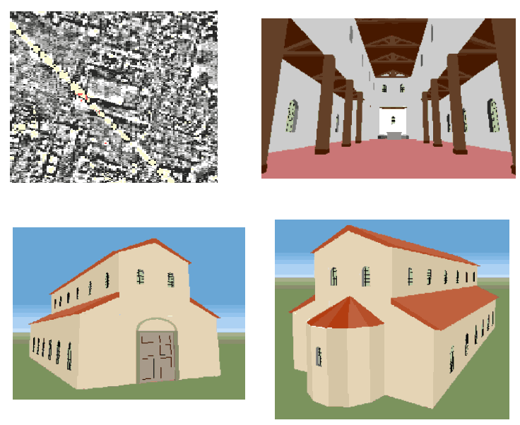
Recreation of a possible church identified through geophysical survey
Access to Archaeology is using two main approaches to present these data. These comprise a virtual reality reconstruction of the city, together with an interactive, digital landscape representing the Wroxeter Hinterland. Our decision to present the data in this manner springs from the extent and nature of the original data provided from the Wroxeter Hinterland Project.
First there exists a massive dataset for the area within the city of Wroxeter itself, including one of the most extensive remote sensed surveys ever undertaken (Gaffney et al. 1998). The data currently allow the most complete plan of a Roman city available in Britain at present. Most of the town of Wroxeter lies buried under pasture land, with only about 1% of the archaeological remains exposed and visible to the visitor.
In deciding how to present these data to a larger audience, it seemed natural that one potential route was to do so as a virtual reality reconstruction. This part of Access to Archaeology was always likely to have the most popular appeal, whilst retaining a strong educational value.
The virtual reality reconstruction of Wroxeter, which uses Superscape VRT as a development platform, will allow users to explore our interpretation of Roman Wroxeter during its different phases. Users will be able to move around the fortress and the later city unguided or be taken on themed guided tours. They will be able to enter buildings and learn about the history of Roman Wroxeter, life in Roman Britain, and find out about the reconstructions and what they are based on. Specific buildings and areas will have explanatory text attached, which will be presented at several levels of detail.
To see the some reconstructions on BUFAU's web site you need Superscape's free plug-in Viscape. The worlds are currently only scripted to work properly in Netscape Navigator.
Apart from the data for the city itself, there is the vast collection of data for the study area as a whole, and which comprises: regional and national archaeological databases, results of GIS analysis, field walking surveys, parish surveys, excavation, interpretation of aerial photography and the photographs themselves. Currently these data exist as a collection of individual databases, database records and images. We felt that they should be made available in ways that are accessible and simple but as unrestricted as possible.
This situation suggested that a software application in the form of an interactive landscape would allow users to display maps and plans for areas of the landscape around Wroxeter. Here they could query the Wroxeter Hinterland database and overlay positions of sites on to the backdrops, as well as being able to overlay linear data such as roads and streams. The users can then display textual data about specific sites, and images including aerial photographs or remote sensing data. A data structure has been designed that treats the data as a multi-layered entity, allowing the user to look more closely at chosen areas with a high density of data. This data structure also makes the application reusable for other datasets. As long as the data are formatted in the specified way, then the application could be used to display data for any area. The digital landscape application is being developed in Java to allow Internet delivery.
In many ways the Access to Archaeology Project epitomises many of the trends within digital dissemination. In its integration of interactive, web-based data sources with virtual reconstructions it begins to incorporate reader choice into publication, although these choices are still currently limited by the emerging technologies and data structures.
© Internet Archaeology
URL: http://intarch.ac.uk/journal/issue6/gaffney/virtual.html
Last updated: Tue March 9 1999