Cite this as: McCormick, F. and Nicolas, M. 2022 Impacts of Climate Change on Coastal Archaeological Sites in County Kerry, Ireland, Internet Archaeology 60. https://doi.org/10.11141/ia.60.2
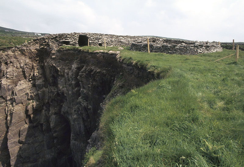
Dunbeg Promontory Fort is located on a sheer cliff overlooking the Dingle Peninsula in County Kerry, Ireland (Figure 1; Cuppage 1986). It is a National Monument site in state guardianship and is one of the Wild Atlantic Way coastal touring sites. The access path to the site is privately owned by a local family. The fort contains four outer defensive banks of stone and earth. Inside the fort are the remains of a drystone Clochán (beehive hut) and a souterrain (Harbison 1992). There is difficulty in determining a precise date for the site owing to the absence of dateable finds and records. A radiocarbon date from the inner fosse suggests that it dated back to the 8th or 9th centuries AD. Another radiocarbon date of the layers in the Clochán suggests that it was inhabited in the 10th or 11th centuries AD.

Dunbeg Promontory Fort is a National Monument (No. 177), protected under the National Monuments (Amendment) Act 1994, and listed under the Record of Monuments and Places (RMP) number KE052-270 (in Historic Environment Viewer). It is also a designated Special Protection Area (SPA) under the EU Birds Directive and an iconic example of Irish coastal promontory forts and is one of many well-visited sites on the Dingle peninsula.
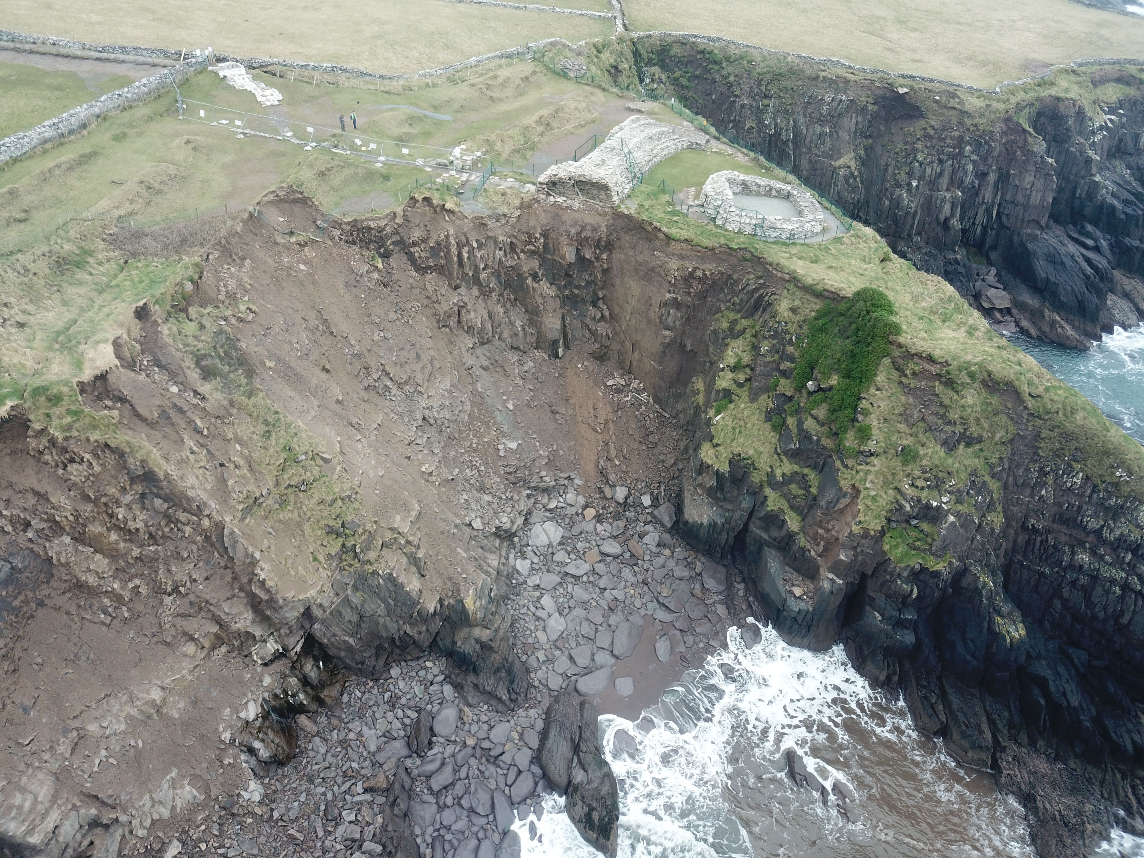
The location of Dunbeg Fort is making it vulnerable to natural weather events and is threatening the site's existence (Figure 2, Figure 3). The fort suffered from extensive coastal erosion in the early 19th century, and in 1977 the Office of Public Works (OPW) carried out an archaeological excavation to record the site and its history before any further damage could occur. The excavations were carried out by archaeologist Terry Barry. Further locations have been excavated in 2018 by consultant archaeologist Laurence Dunne.

A considerable part of the cliff collapsed into the sea in recent years owing to the increased frequency and severity of storms and precipitation. This has led to significant loss of the historic fabric and archaeological elements. The site is particularly vulnerable during the winter season between December and February because of its exposed location. A storm in January 2014 caused a portion of the cliff to collapse into the sea. Between 2017 and 2018, severe weather caused further damage and a significant part of the historic fabric, including the entranceway, was lost into the sea (Figure 4). The dramatic collapse sparked national attention and was covered in the national news (RTÉ 2018).
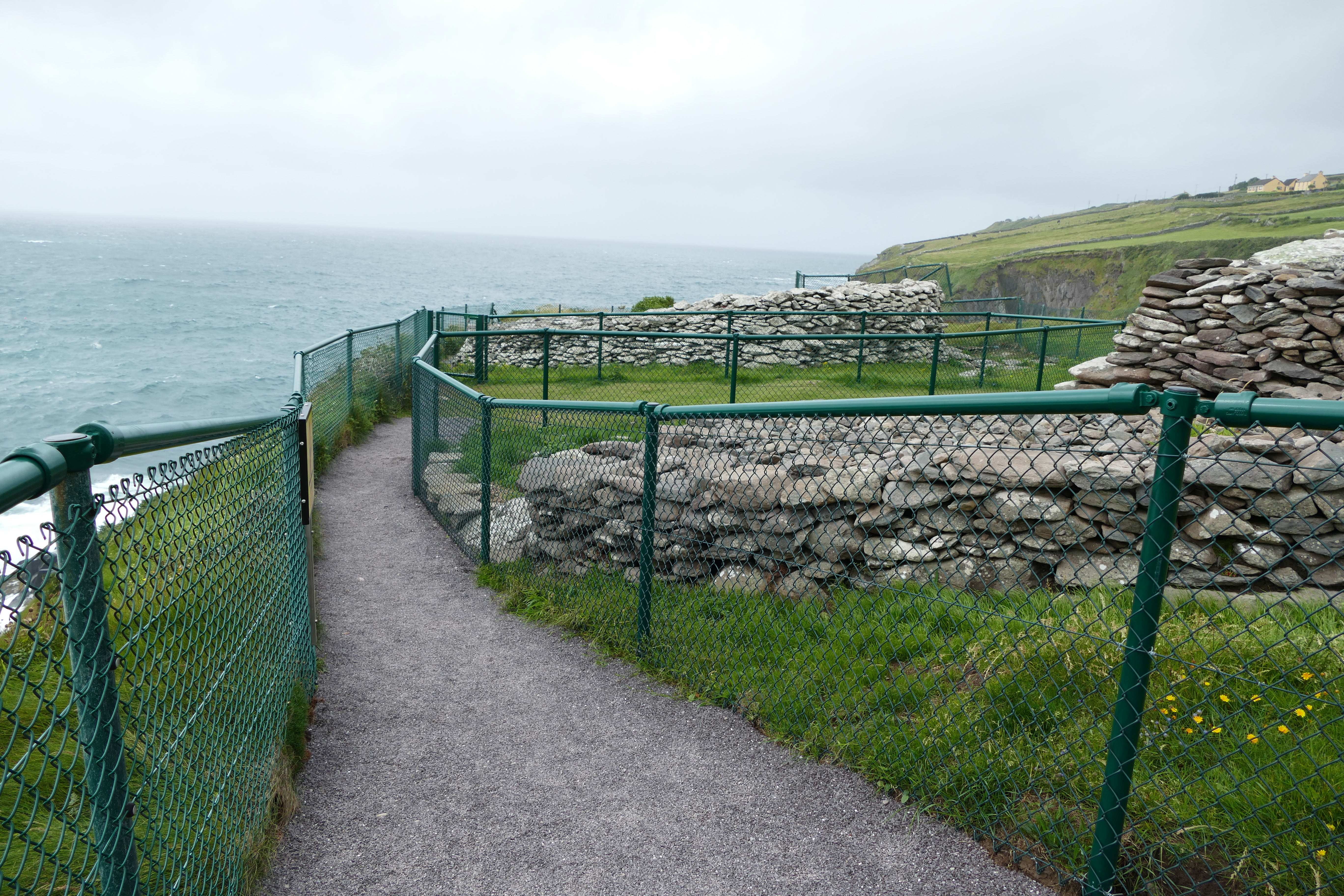
The OPW has adopted a policy of managed retreat for the site. The aim was to adapt to the present climate effects and to provide safe access for visitors. After the dramatic 2017 cliff collapse, the OPW applied for a Ministerial Consent from the Department of Housing, Local Government and Heritage (DHLGH) to erect a boundary fence that kept visitors and tourists away from the dangerous parts of the site. Access could not be allowed until a safety risk assessment was carried out and a report was issued. The OPW commissioned consultant engineers to carry out a geophysical survey of the site. The site will now be continuously monitored to ensure visitors' safety. The Discovery Programme has also surveyed the site using Unmanned Aerial Vehicle (UAV) mapping. The Discovery Programme will carry out survey works at Dunbeg Fort on a yearly basis to monitor any changes that might occur. It is worth noting that in the case of sudden and dramatic collapse, the site will be closed immediately and access will be restricted to OPW personnel only.
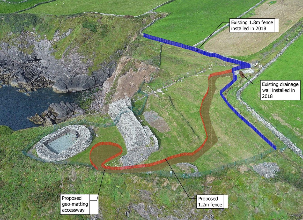
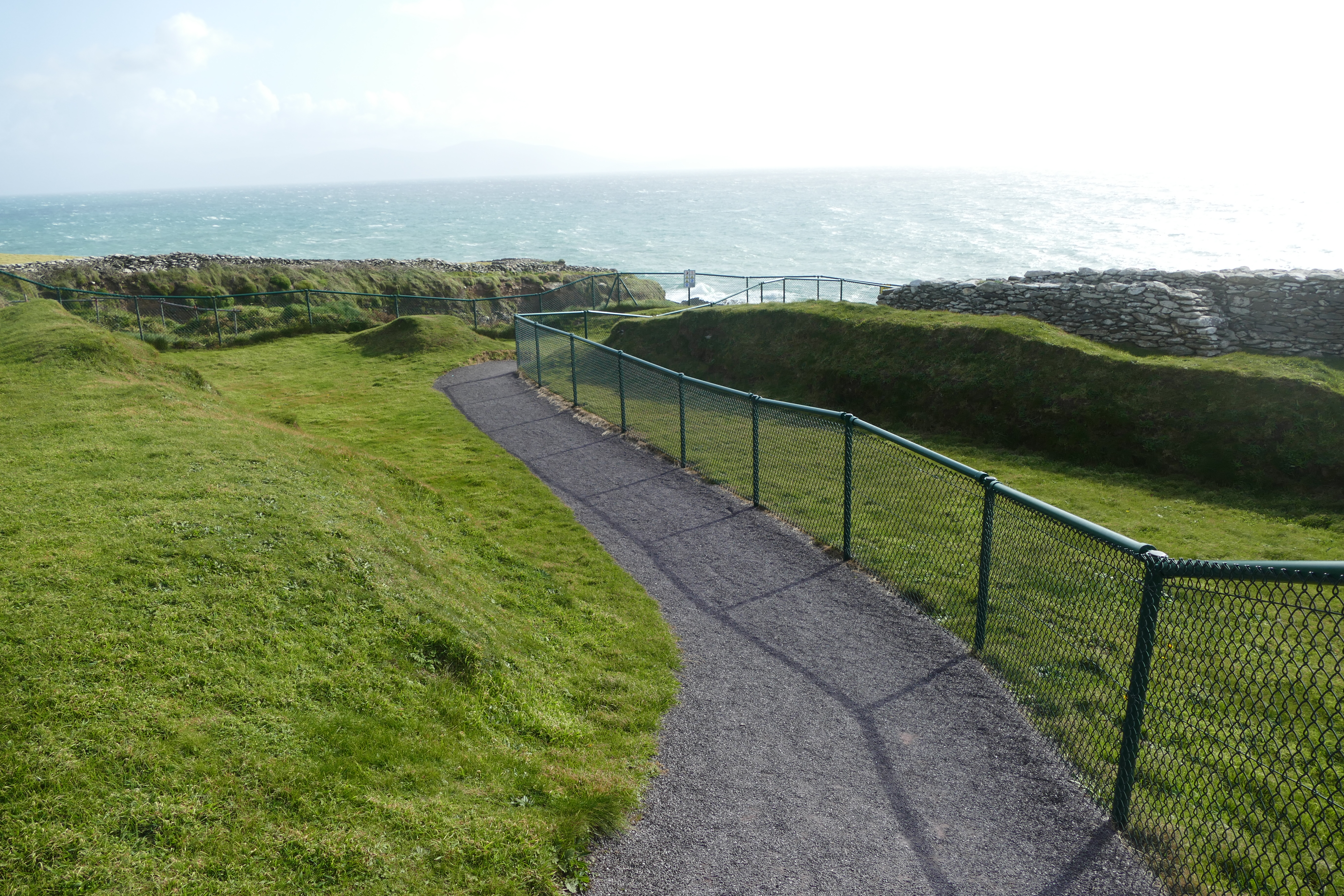
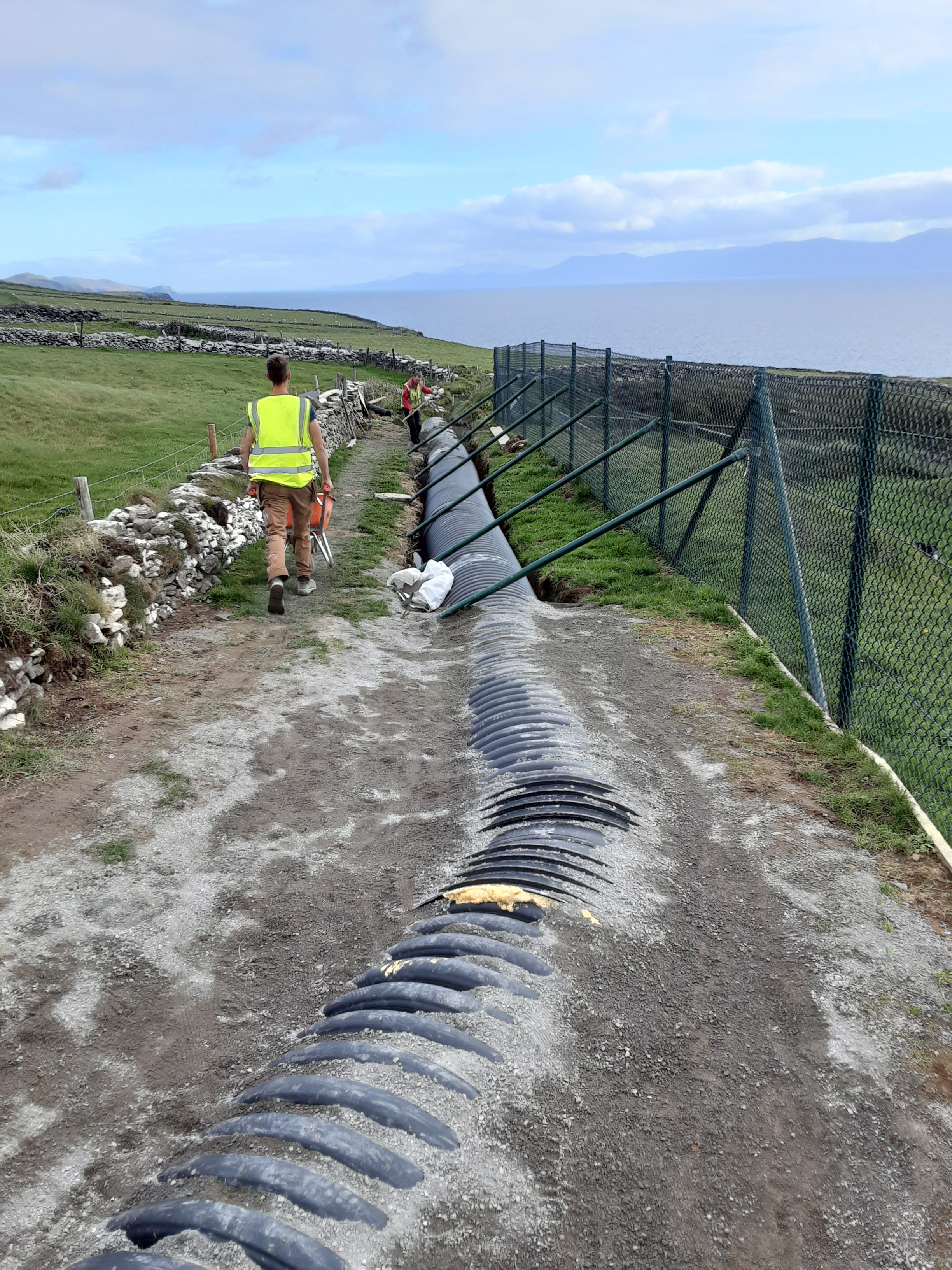
The OPW applied for a second Ministerial Consent in 2018/2019 to install fencing to limit visitors' access to specific areas that are considered safe. The existing drainage system has also been repaired and a new drainage wall has been constructed to redirect floodwater from the site. Dunbeg Fort was reopened in 2019 to allow visitors to the site and so benefit the local tourist economy. However, the drainage repairs carried out in 2019 were insufficient to protect the site from flooding. As a result, the OPW have installed new culvert drainage pipework to mitigate the risk of flooding.
The OPW has also applied for a Ministerial Consent from DHLGH in 2022 to install fencing and repair the existing pathway connecting the main road to the National Monument site (Figures 5-9). The Ministerial Consent will be accompanied by an archaeological method statement report. It is proposed to carry out the repair works to the pathway and the fence installation in 2022.

The OPW and DHLGH will install interpretation signage on site that will include a brief history of the site and educational information on climate change. The aim is to raise awareness of the visitors about the impact and challenges caused by climate change on the site.
Further coastal erosion to the site caused by climate change is progressive and inevitable. The repair works on site have required substantial labour and financial resources. A wide range of specialists have been involved with the proposed works including the DHLGH archaeologists, OPW architects, consultant engineers, consultant archaeologists, OPW direct labour force etc. Local landowners and politicians have also been consulted. The site has been accurately surveyed to assess the damage and ongoing erosion. By keeping the site accessible to visitors, the OPW hopes to raise awareness among the public and visitors to the effects of climate change on coastal heritage sites. Similarly, the site can now be used as a case study for other vulnerable coastal heritage sites regarding adaptation to the effects of climate change.
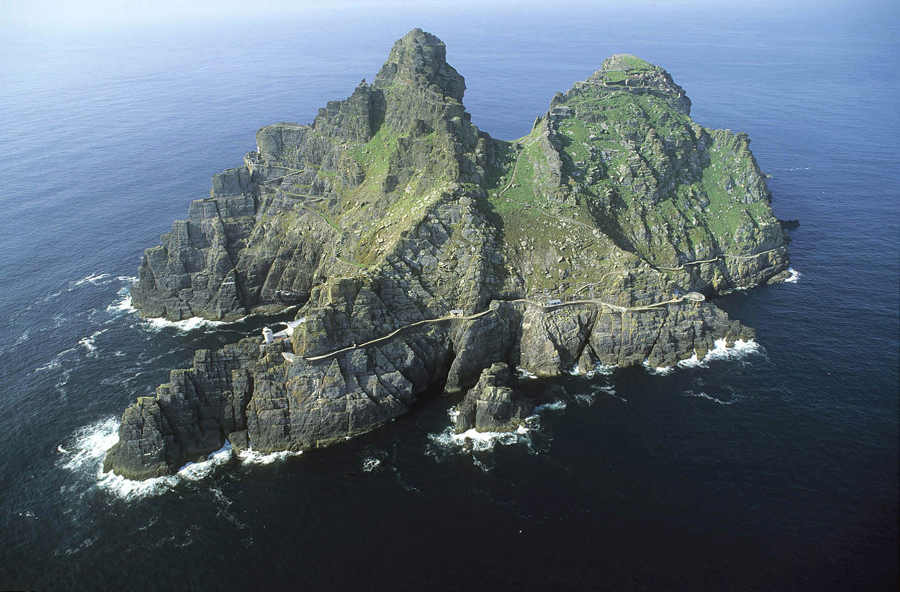
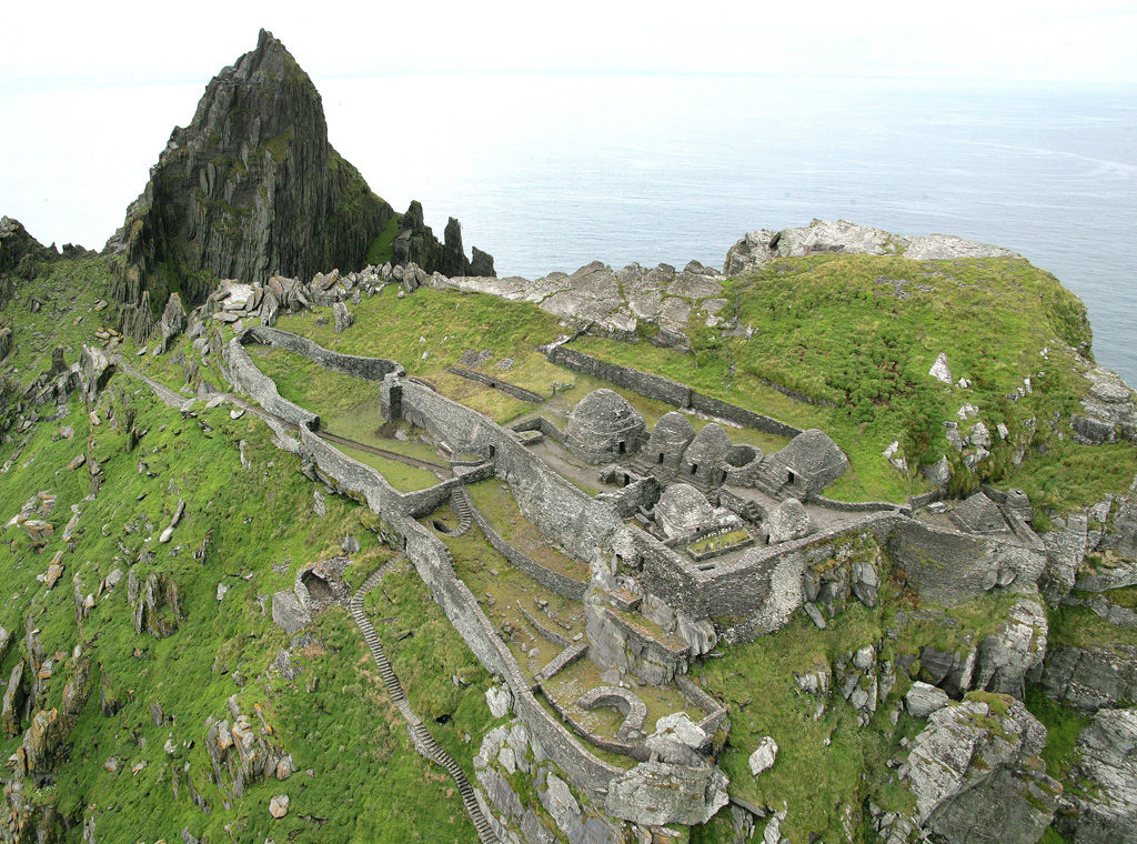
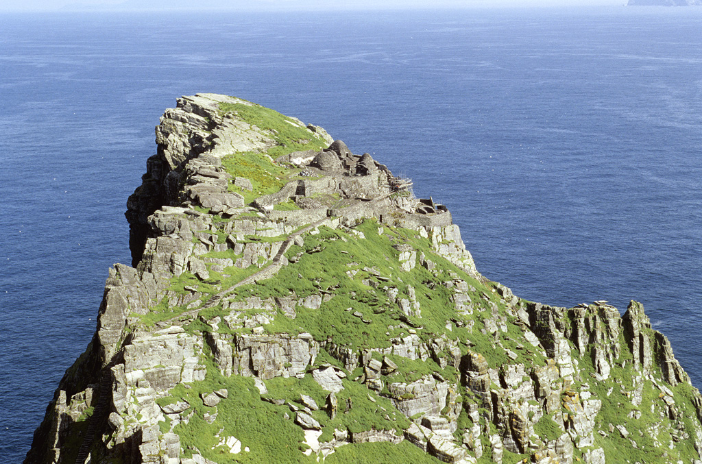
Skellig Michael (UNESCO 2020) is an island located 13km off the South Kerry Coast and is home to an early medieval monastic site (Figure 10; KE104 in the Historic Environment Viewer). It was founded c. 6th century by Saint Fionán. The medieval monastery is dramatically situated on the top of this rocky island in the Atlantic Ocean (Figure 11, Figure 12). As a result of climate change and increasingly rough seas, the monks later transferred to the mainland at Ballinskelligs Priory (Harbison 1992).
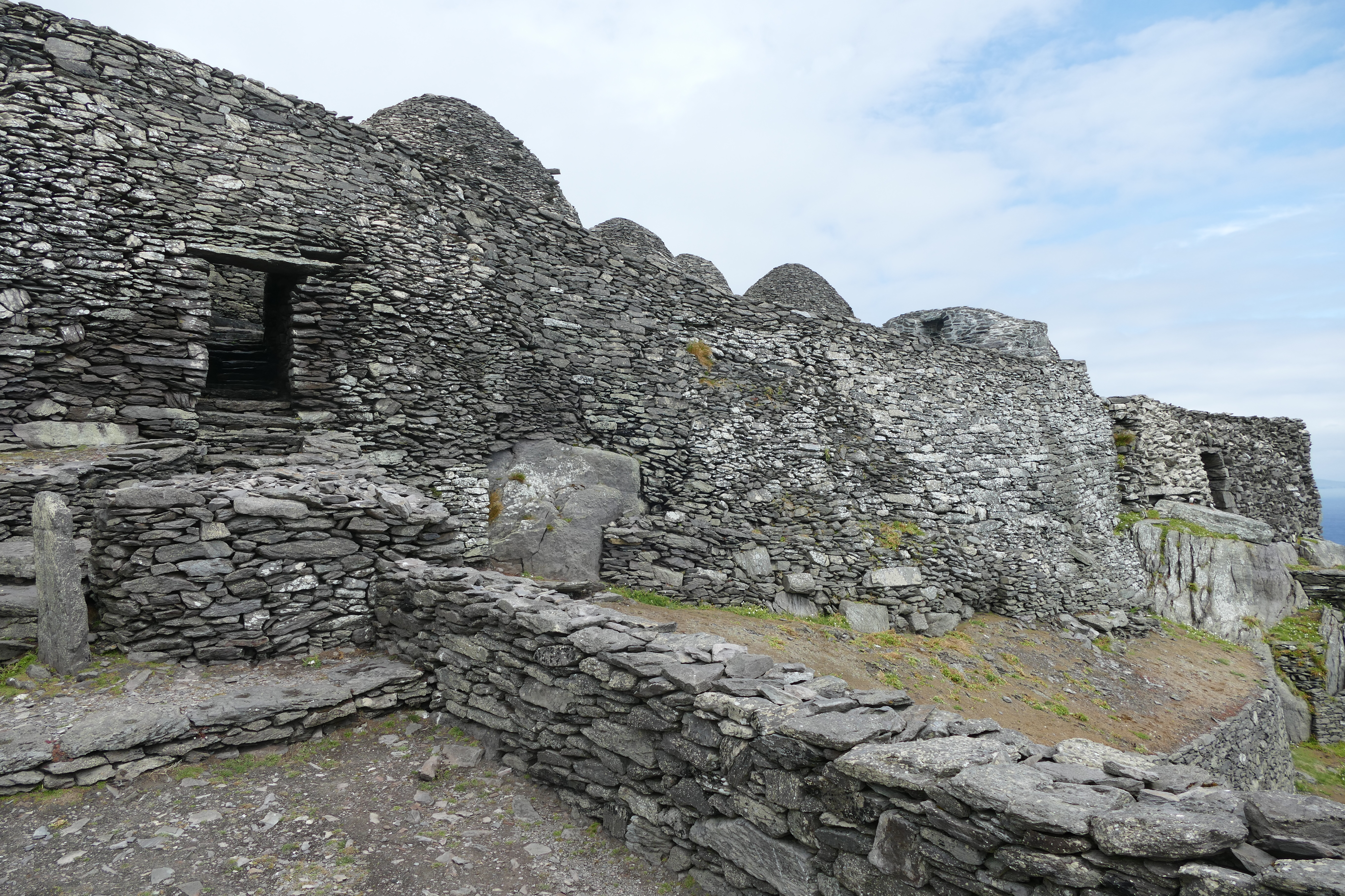
There are two major international sites of interest on the island. The monastery enclosure located on the eastern side of the island contains a series of terraces, dry stone enclosing walls, three cisterns, seven corbelled cells (six intact) and two oratories. There are also the remains of St Michael's chapel. The monastic settlement was accessed via a series of three stairways, only one of which is accessible today. The South Peak contains the remains of a hermitage, constructed ledges and altar remains. The other features include a pier, a helipad and two lighthouses built in the 1820s and a lighthouse road.
The monastery came into state care in 1880 and the OPW took on responsibility for managing and maintaining the monastic site. Since that time, the OPW has continued in its efforts to maintain and preserve the monastic remains. The island also contains two lighthouses; the lower lighthouse and upper lighthouse, built by the Commissioners of Irish Lights in 1821. The Lower and Upper Lighthouses represent good examples of typical 19th-century lighthouse architecture and are the subject of proposed long-term repair and restoration works by the OPW.
Skellig Michael was inscribed on the World Heritage List in 1996 for its unique cultural and natural attributes. The uniqueness of the dry stone monastic structures displays the architectural achievement of the monks in such a remote and severe environment. The island is also important for being a destination for breeding seabirds and has a unique eco-system. Skellig Michael is a designated Special Area of Conservation (SAC) under the Habitats Directive (92/43/EEC) and a designated Special Protected Area (SPA) under the Birds Directive (79/409/EEC). Both directives form part of Natura 2000, a European network of protected sites.
Skellig Michael is accessed by boats departing from Portmagee or Knight's Town on Valentia Island. Boats land at the pier and passengers disembark by climbing the steps (Figure 13). The visitors then ascend the Lower Lighthouse Road to reach the base of the eastern steps, where an OPW guide gives an induction before directing them to the monastery steps. Additional guides are located at the monastery complex, completing the tour.

Climate change continues to be a threat to Skellig Michael and the OPW are continuously looking for ways to mitigate its associated risks. One section of the monastery retaining wall at Skellig Michael has become structurally unstable owing to the increase in rainfall and rainwater draining through it.
The OPW has commissioned The Discovery Programme to monitor the movement of the wall on a yearly basis. The Discovery Programme undertake a survey of the monastic settlement every year and publish their findings to the OPW. The latest 2021 report confirmed that the section of the retaining wall directly below St Michael's chapel is currently undergoing minor movement beyond acceptable tolerances, but at a slightly reduced rate than that observed in 2020. This section of the monastic wall has been historically susceptible to collapse, with major reconstruction having been undertaken during the 19th century. The OPW is proposing the careful dismantling and rebuilding of the wall to address the rainwater drainage issue. The monastery wall will have to be carefully reconstructed without compromising the site's authenticity and Outstanding Universal Value (OUV).
The OPW appointed Paul Corrigan Associates (PCA) surveyors in 2022 to carry out a digital survey of the monastery and retaining wall (Figure 14). The survey works were completed in the 2022 season and the survey drawings were issued to the OPW. The survey drawings will allow the OPW to determine the conservation methods to be adopted in proposed future conservation works. These will also form the basis for Ministerial consent applications, design decisions and tender packages.
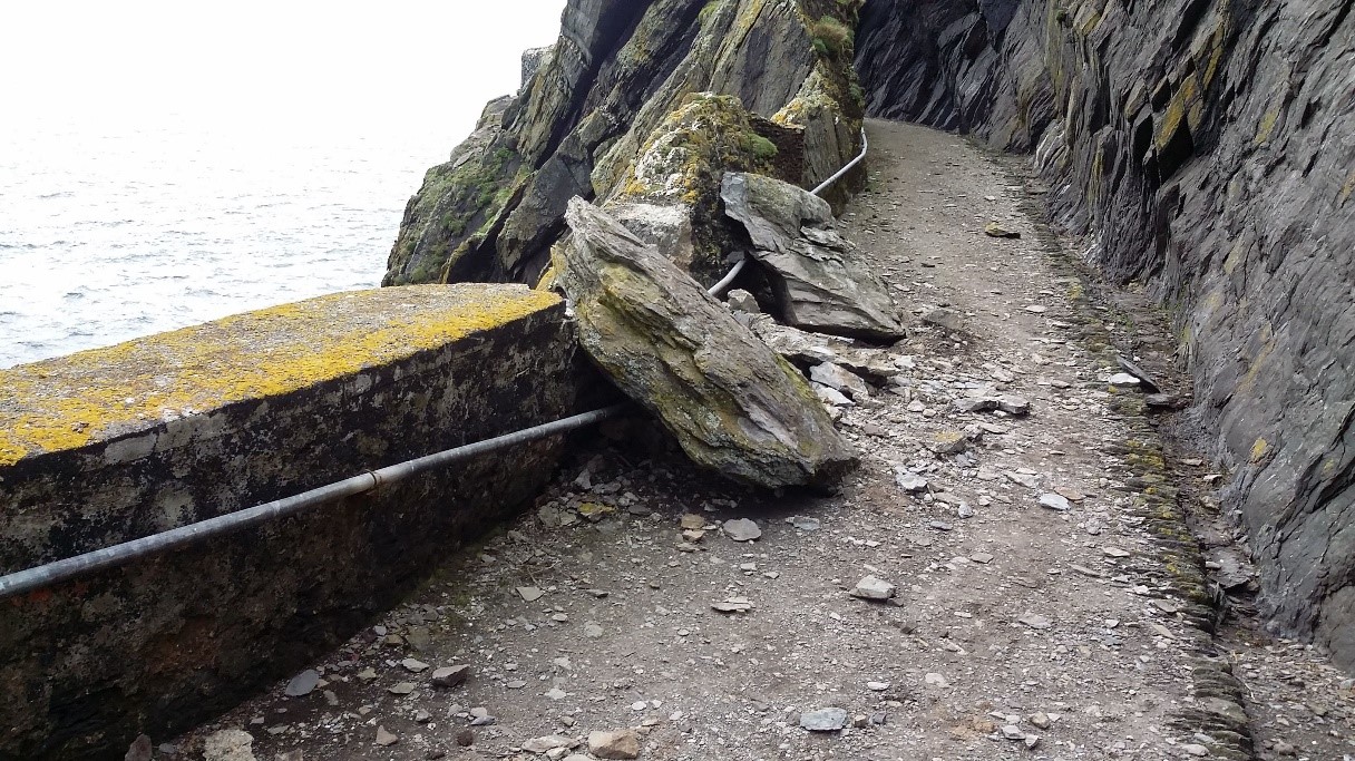
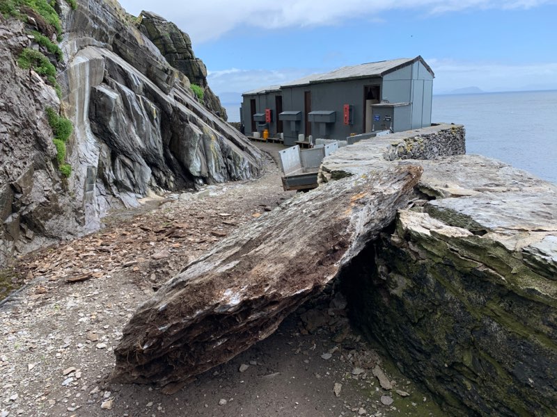
In recent years, increased rainfall has also resulted in increased rock fall that is damaging the fabric of the site and threatening the safety of both OPW staff and visitors to the island. In 2017, a rock fall occurred near the guides' accommodation, causing a major safety risk for staff (Figure 15). The increased rock fall at the time caused damage to the lighthouse road, an important architectural feature. The erosion is also the result of natural causes such as wildlife burrowing on site. Another serious rock fall occurred in July 2020 near the OPW workers' huts (Figure 16). This has highlighted the urgency of installing new permanent crash decks to protect OPW workers in area at high risk from rock fall events.
Presently, the OPW carries out maintenance works four weeks prior to the opening of the island for visitors during summer. The island is normally open to visitors from May to October during the summer season. If the damage caused by rock falls increases, then the maintenance period will have to be extended accordingly.
Skellig Michael was closed to the public in the 2020 season owing to the Covid-19 restrictions. The site was also closed to the public at the start of the 2021 season. However, the island re-opened for tourists on 1 July 2021 following an announcement by the OPW Minister, Patrick O'Donovan, on 2 June 2021. Despite the Covid-19 challenges, the OPW undertook maintenance and repair works to ensure the continued preservation of the monastic settlement and steps.
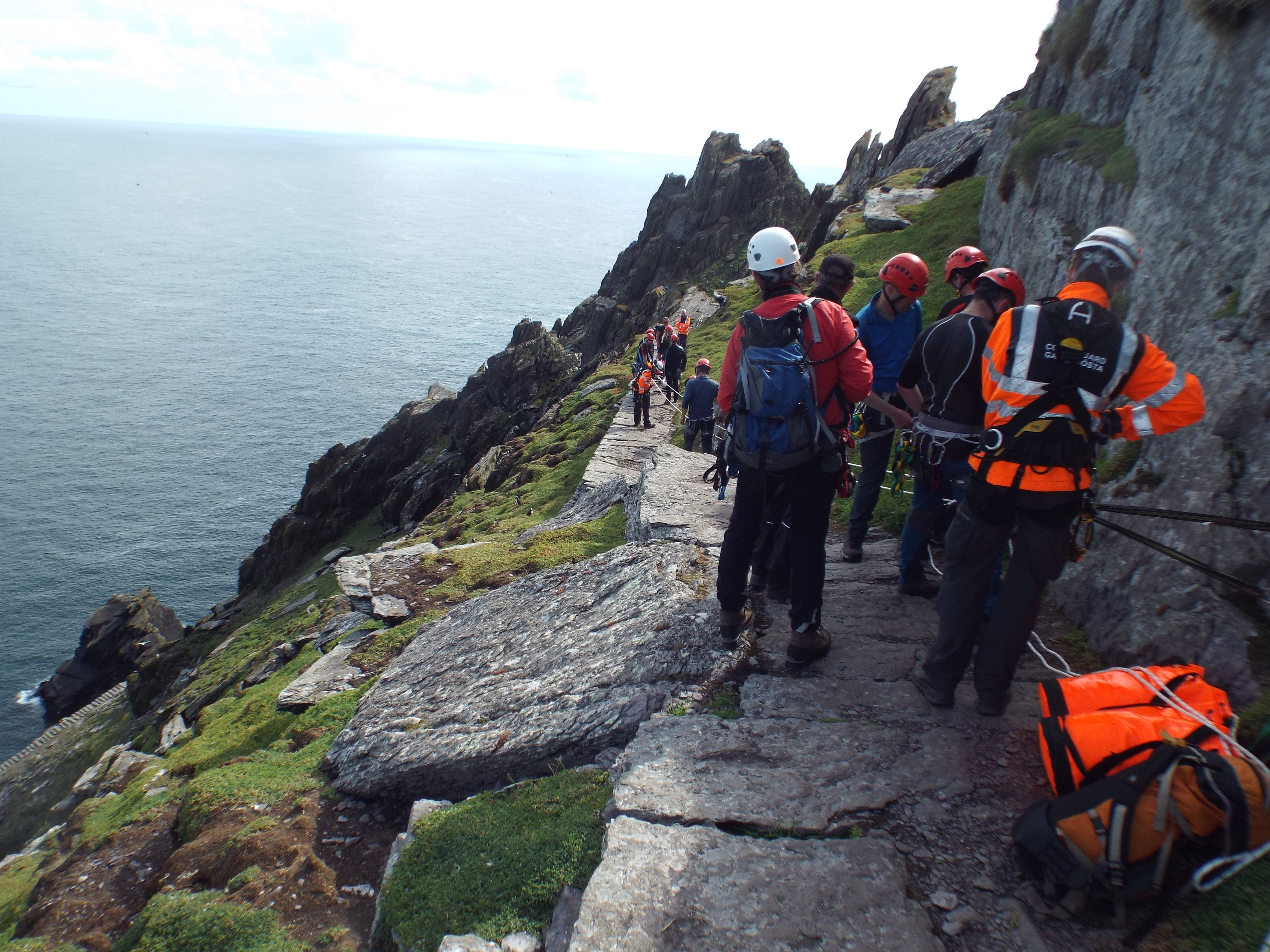
The physical nature of the island and the uneven monastic steps are challenging to visitors and can cause serious accidents and injuries. The OPW has carried out two rescue exercises in 2019 that involved bringing a dummy casualty from the monastery to the pier on a stretcher (Figure 17). The Irish Coastguard Mountain Rescue team were involved in the rescue exercise and it is envisaged that a rescue exercise will take place during June of every year.
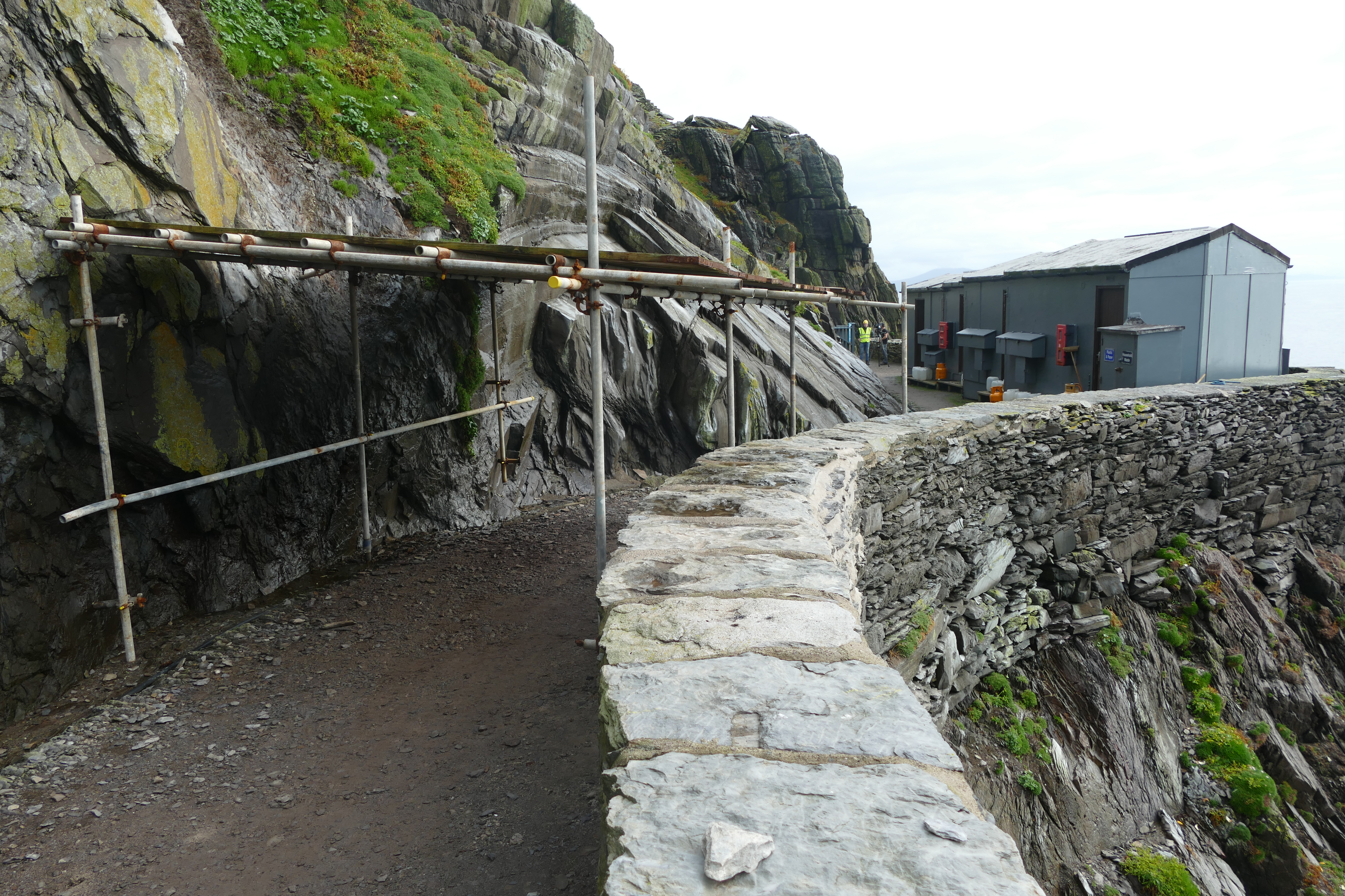
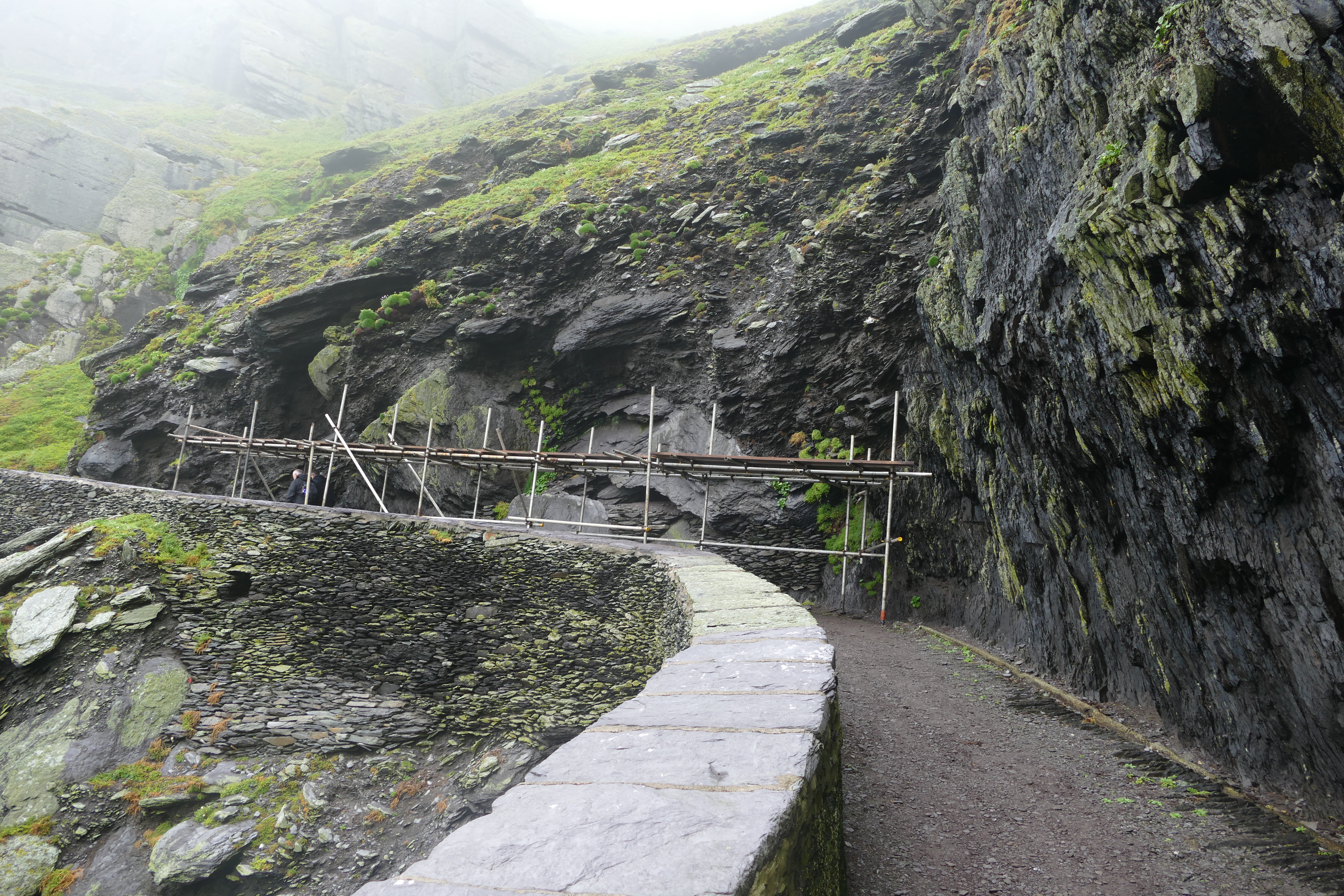
Rock fall is a high-risk threat to the safety of OPW staff and visitors. Both rock fall and increased rainwater are damaging the unique historic fabric of the site. The substantial rock fall that occurred in 2020 resulted in the installation of temporary crash decks in locations with high incidence of rock falls (Figure 18, Figure 19).
In response to the threat to the health and safety of the workers, the OPW appointed Downes Associates as consultant structural engineers in 2021 for the design of three permanent crash decks in the critical locations on the Lighthouse Road. The OPW obtained DHLGH Ministerial Consent in August 2021 for the installation of permanent crash decks. The OPW also appointed a consultant quantity surveying firm, Rogerson Reddan, for the tendering process of appointing a contractor. The tender invitations were issued in 2021 but the process took longer than envisaged and there was not enough time to carry out the works. As a result, the OPW intend to re-issue tender invitations in 2022 and appoint a contractor for the installation of the crash decks.
The installation of permanent, well-designed and robust crash decks is critical for the safety and wellbeing of OPW workers on site and for the future access and use of the upper lighthouse road by visitors. The viability of the island as an accessible tourist location is dependent on safe access conditions on the lighthouse roads.
The increase in sea levels, sea swells and the increasing severity of storms have also been affecting access to the landing pier (Figure 20). The number of days when tourists can access the island during the summer tourist season has been steadily decreasing. The viability of the island as a tourist destination will be affected by climate change. The OPW are exploring long-term solutions to enhance the landing to the island and compensate for rising sea levels. A pier wall will be constructed to protect visitors from increased swells and higher tides. There is a more long-term strategy of increasing the height of the pier to accommodate predicted sea level rises resulting from climate change. The OPW will keep maintaining and carrying out repairs to the existing pier as required to ensure safe landing onto the island.

OPW are in discussion with Met Éireann, the Irish national meteorological organisation, to install a proposed weather station on the site to provide an accurate record of weather events and to monitor changing climatic patterns.
The OPW also appointed Carrig Conservation to carry out a climate change vulnerability assessment (CVA) of Skellig Michael. Stakeholders and community workshops will be consulted in 2022 and the results will be summarised in a final report issued to OPW. The aim of this report is to assess the impacts and risks caused by climate change on Skellig Michael. The report will provide recommendations that the OPW will take into consideration when tackling the impacts of climate change on the historic fabric.
The OPW also installed new visitors' dry toilets in the 2021 season near the helipad on the lighthouse road (Figure 21). The works were subject to Ministerial Consent which was granted by the DHLGH in May 2021. The visitor toilets opened to the public on 24 August 2021 and are the first public toilets to be constructed on the island. They consist of two dry toilets and hand sanitation stations. Improving toilets and hygiene facilities on the island has become a necessity following the Covid-19 pandemic. The installation of such toilets is important for the viability of Skellig Michael as a World Heritage site and tourist destination.

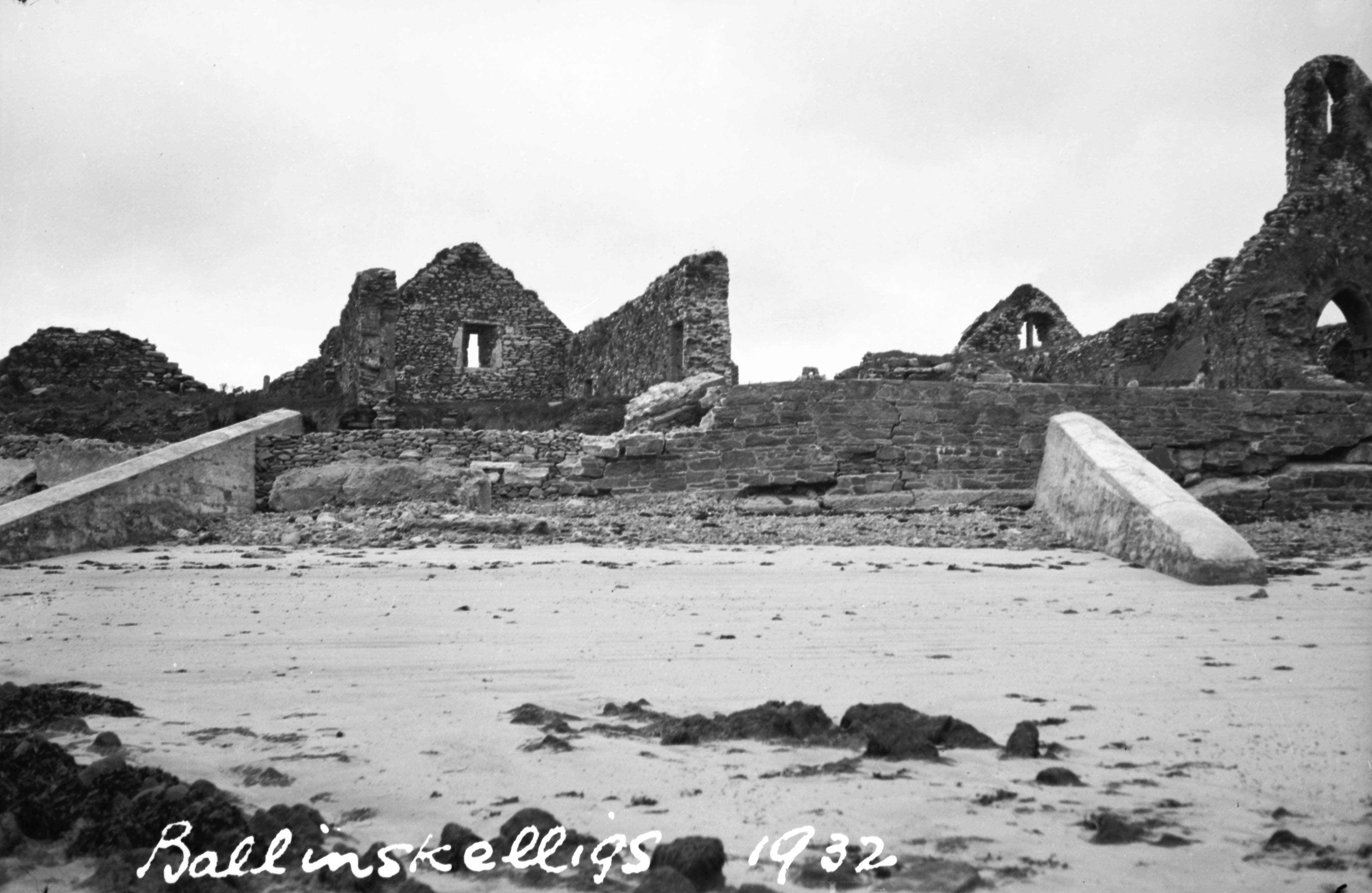
Ballinskelligs Priory is located on the west shore of Ballinskelligs bay in County Kerry (Figure 22, Figure 23). It was founded by the monks who came to the mainland from Skellig Michael between the 12th and 13th centuries. The remaining structures on site date back to the 15th century. They include two churches that have windows and doors with dressed stones, and a cloister garth with a large hall (Harbison 1992). Ballinskelligs Priory is one of the significant spiritual sites dedicated to St Michael in the area. It is a destination for visitors searching for spirituality and history. Its location on the Wild Atlantic Way also makes it a main tourist destination. The site contains a large graveyard that is still in use by the local community.
Ballinskelligs Priory is a National Monument (No. 168) protected under the National Monuments (Amendment) Act 1994 and listed under the Record of Monuments and Places (RMP) number KE097-036 (see the Historic Environment Viewer). Ballinskelligs Priory is also a designated Special Area of Conservation (SAC) protected under the EU Habitats Directive. The directive forms part of Natura 2000, a European network of protected sites.
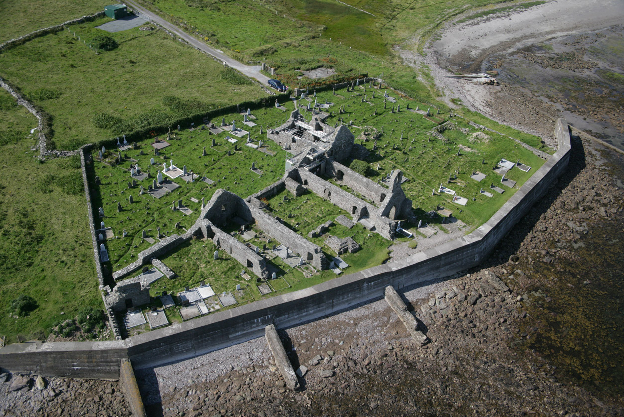
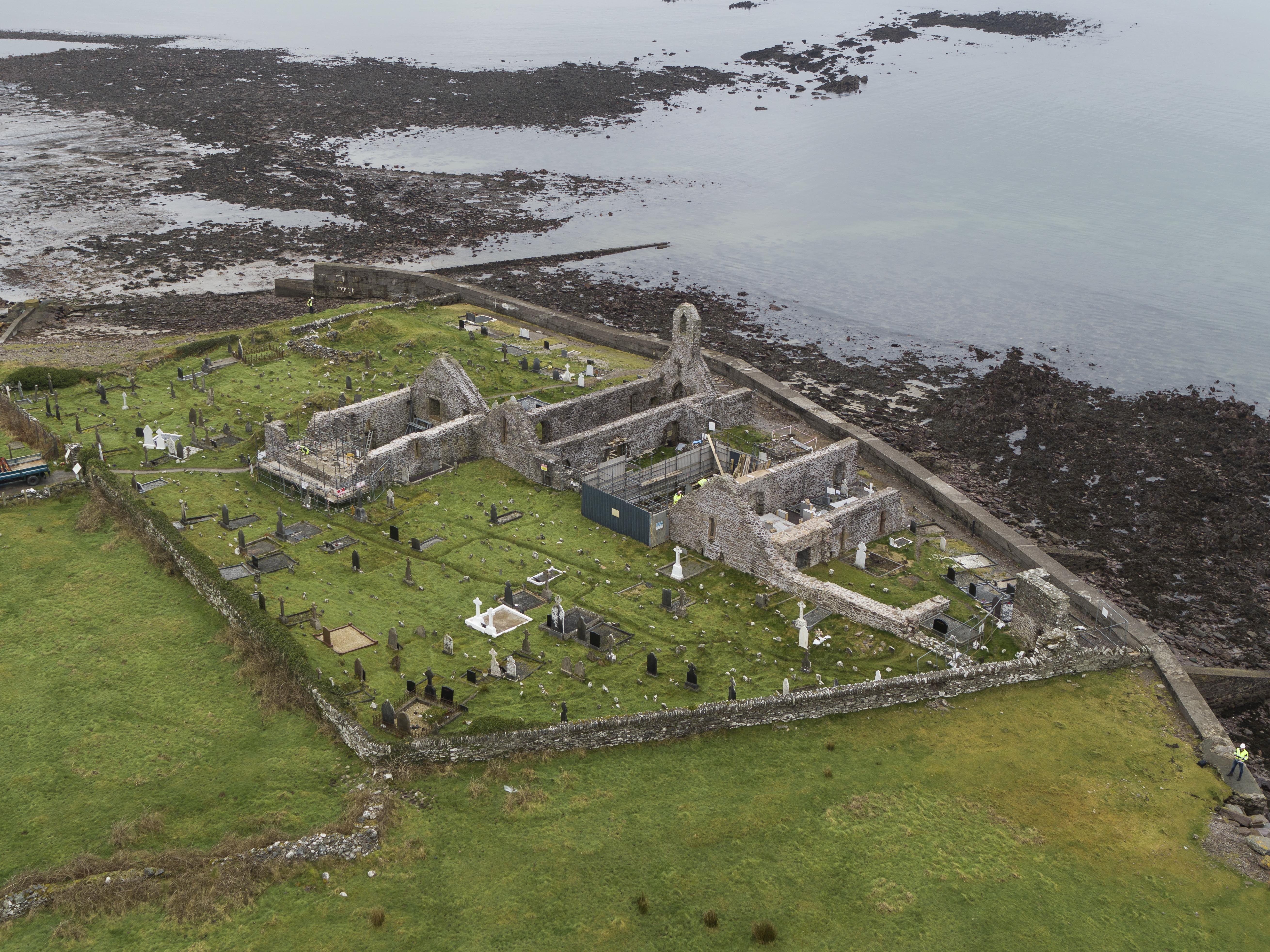
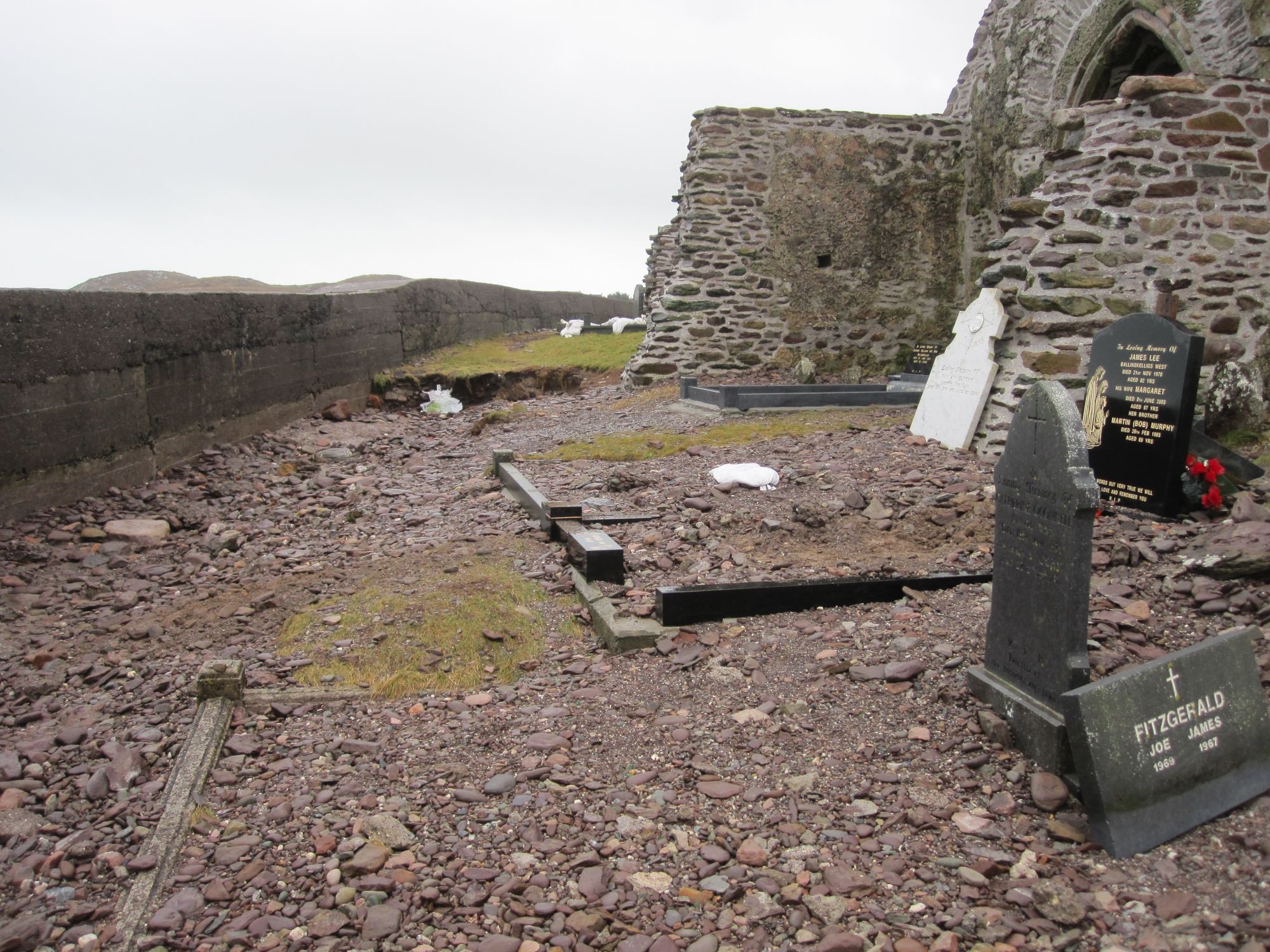
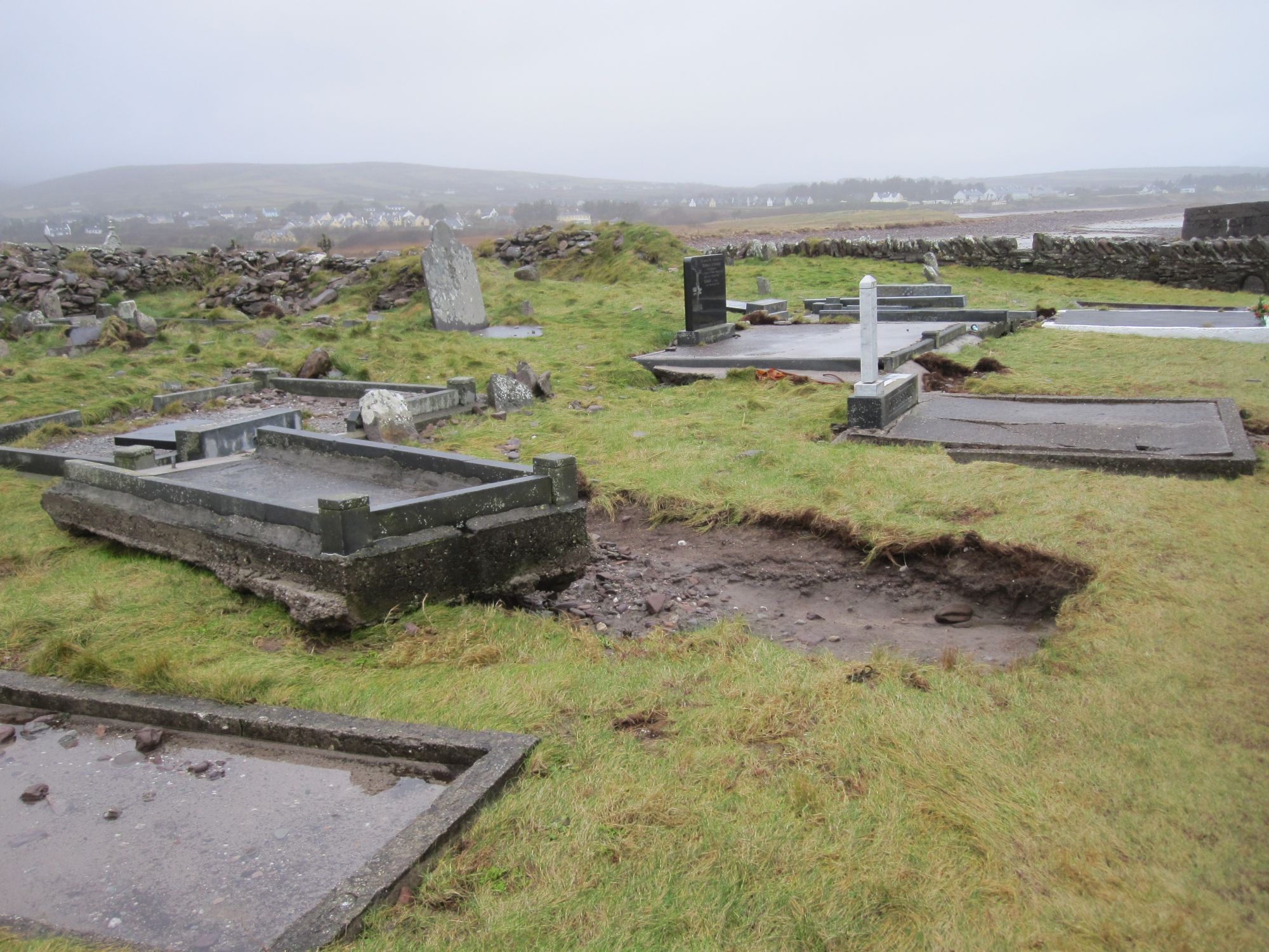
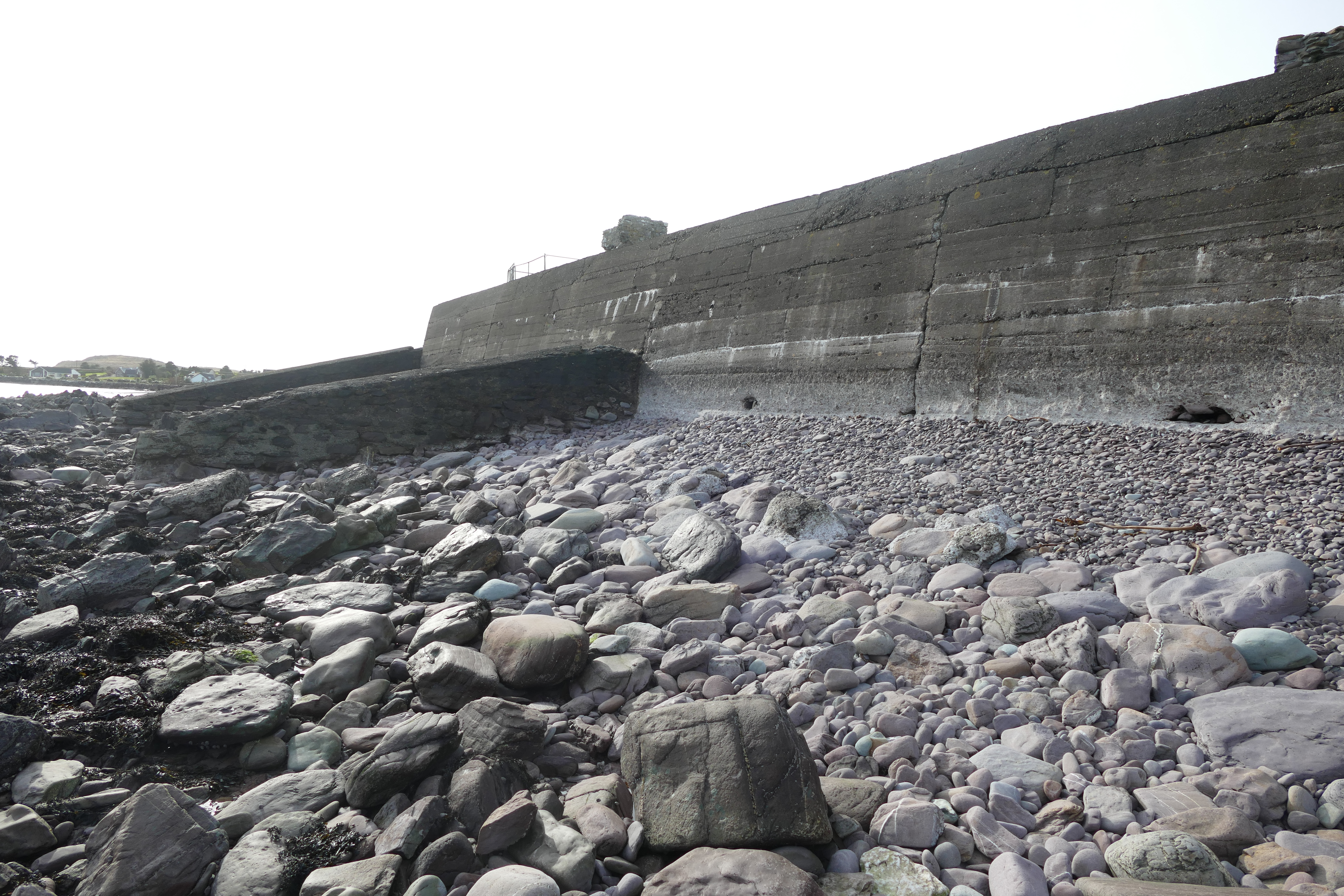
A significant amount of this historic site has been lost to coastal erosion throughout the years. As a result, a concrete sea wall was built in the 1950s to prevent further loss of the historic fabric. The sea wall is now deteriorating and is in urgent need of upgrading and repair. The OPW has been carrying out conservation and repair works to the priory for the past 10 years. In recent years, the increasing storm surge and water penetration to the site and over the sea wall has caused damage to the ruined structures and threatened their survival (Figure 24, Figure 25).
The OPW appointed a consultant archaeologist, Laurence Dunne, to monitor the conservation works on site. The consultant archaeologist issued archaeological reports to the OPW in 2019 and 2020.
As the conservation works on site are nearing their end, the OPW intend to carry out a digital survey of the site once all works are complete. The sea wall is to be included in the survey works. The survey information will form the basis for Ministerial consent applications, design proposals and tender packages.
The OPW are regularly decreasing the site's vulnerability to climatic effects through regular maintenance and conservation to the existing structures. This allows for an increased protection of the monument against strong winds and extreme storms. However, the exposed location of the site and the increase in storm intensity require additional mitigating measures to be undertaken by the OPW.
The OPW commissioned Malachy Walsh and Partners (MWP 2019) to carry out a structural inspection of the concrete sea wall in September 2019. The report for proposed repairs to the sea wall was issued to the OPW in October 2019. MWP provided recommendations at the end of their report, which will be considered by OPW for the proposed repairs to the sea wall.
The OPW has also commissioned conservation consultants Carrig Conservation to carry out a climate change risk assessment on the site, the first one of its kind on a national monument site in Ireland. Carrig issued a report to the OPW in June 2020. The aim of the risk assessment is to identify the potential risks to the site and to develop a Climate Change Adaptation Guide.
The OPW has also commissioned The Discovery Programme to carry out a scan survey of the site and to monitor the coastal erosion on an annual basis (Figure 26, Figure 27). The survey data will be used to appoint a specialist consultant to advise on further coastal protection measures for the site.
The OPW is gathering a team of various consulting experts to advise on the most practicable solution for protection of the site from flood damage and erosion. The expert bodies consulted consist of OPW architects, Kerry County Council, OPW Flood Risk Management Section engineers, consultant structural engineers, DHLGH archaeologists and consultant archaeologists. The repair works to the sea wall will be technically challenging and expensive and have to be carefully discussed with all stakeholders. Any proposed methods for the enhancement and repair of the sea wall must not compromise or damage the ecosystem of the bay. A foreshore licence from Kerry County Council to carry out the works will be required. A Ministerial Consent for carrying out works to the National Monument will also be required from DHLGH (Government of Ireland 2000).
The repair works to the sea wall at Ballinskelligs Priory are a challenging task. The works will have to be carried out in a sustainable manner and the project has to be accurately costed. The health and safety of the workers on site will be prioritised especially during high tide and the completed works will have to be protected from any potential damage. Once repairs to the sea wall are completed, Ballinskelligs Priory will become a case study for other vulnerable heritage sites in the area.
In conclusion, the Office of Public Works are carrying out regular monitoring and applying mitigating measures to reduce the climate change impact on national monument sites. The Office of Public Works are committed to protecting these sites and safeguarding them for future generations.
Internet Archaeology is an open access journal based in the Department of Archaeology, University of York. Except where otherwise noted, content from this work may be used under the terms of the Creative Commons Attribution 3.0 (CC BY) Unported licence, which permits unrestricted use, distribution, and reproduction in any medium, provided that attribution to the author(s), the title of the work, the Internet Archaeology journal and the relevant URL/DOI are given.
Terms and Conditions | Legal Statements | Privacy Policy | Cookies Policy | Citing Internet Archaeology
Internet Archaeology content is preserved for the long term with the Archaeology Data Service (ROR). Help sustain and support open access publication by donating to our Open Access Archaeology Fund.
 Home
Home