Cite this as: Klinke, L. 2023 Cultural Landscape Change from Late Neolithic to Late Middle Ages in Northern Westphalia. Interplay between the natural environment and the anthropogenic archaeological remains, Internet Archaeology 62. https://doi.org/10.11141/ia.62.9
This article deals with a case study in cultural landscape change from Late Neolithic to the Late Middle Ages, summarised in Klinke (in press). The study area is located in northern Westphalia near the city of Osnabrück and covers an area of 625 ha. There are no rivers or streams in the study area, although there are wet lowlands in the north-east and in the south. The soil value classes within the study area are low in yield potential and therefore not very suitable for arable farming. (Figure 1).
For the case study, already analysed pollen data were available. However, both calibrated and uncalibrated data had been used together for the absolute dating, which is why it has not yet been possible to synchronise the botanical data with the archaeological features. Regardless of the faulty dating, however, the palynological analyses within the so-called pollen floristic zonations (PZNWD) were correctly analysed (Barth 2001). As part of the study on cultural landscape change, the archaeobotanical data could be calibrated anew and this time uniformly according to IntCal20. As the revised graph (Figure 2) shows, the pollen floristic zonations are still in correct relation to each other, but would now have to be partially shifted up and down the time axis to ensure accurate temporal calibration.
The pollen diagrams (Figure 3) demonstrate the landscape change based on the changing vegetation. In addition to the variance between tree pollen and non-tree pollen, which generally confirms massive deforestation in more recent times, it is the proportion of tree pollen that illustrates the change of vegetation which characterises the landscape the most. For the transition between Atlantic (PZ VIIINWD) and Subboreal (PZ IXNWD), the elm decline is characteristic in northern Germany (Dincauze 2000). Based on the new calibration, this can be dated in Westphalia to between 3700 and 3500 cal. BC i.e. archaeologically to the transition between the Swifterbant and Funnel Beaker cultures in northern Westphalia and the Michelsberg and Wartberg cultures in southern Westphalia. Furthermore, it is striking that beech is only regularly present from the Iron Age onwards and that birch becomes more prominent from the early Middle Ages onwards.
Agricultural and settlement indicators can be found permanently from the end of the Neolithic onwards, which is why it can be assumed that livestock farming increased in the Late Neolithic in the area. Meadow and trampling indicators, in combination with the expansion of browsing-resistant plants, led to the emergence of the first heathlands.
Hypothetically, different vegetation sites can be defined on the basis of soil type, soil texture and hydrological conditions, where different plants have grown at different times. Based on the natural conditions in combination with the vegetation changes detected in the pollen diagrams, a concrete historical (cultural) landscape dynamic can be reconstructed, although this is of course only hypothetical in character.
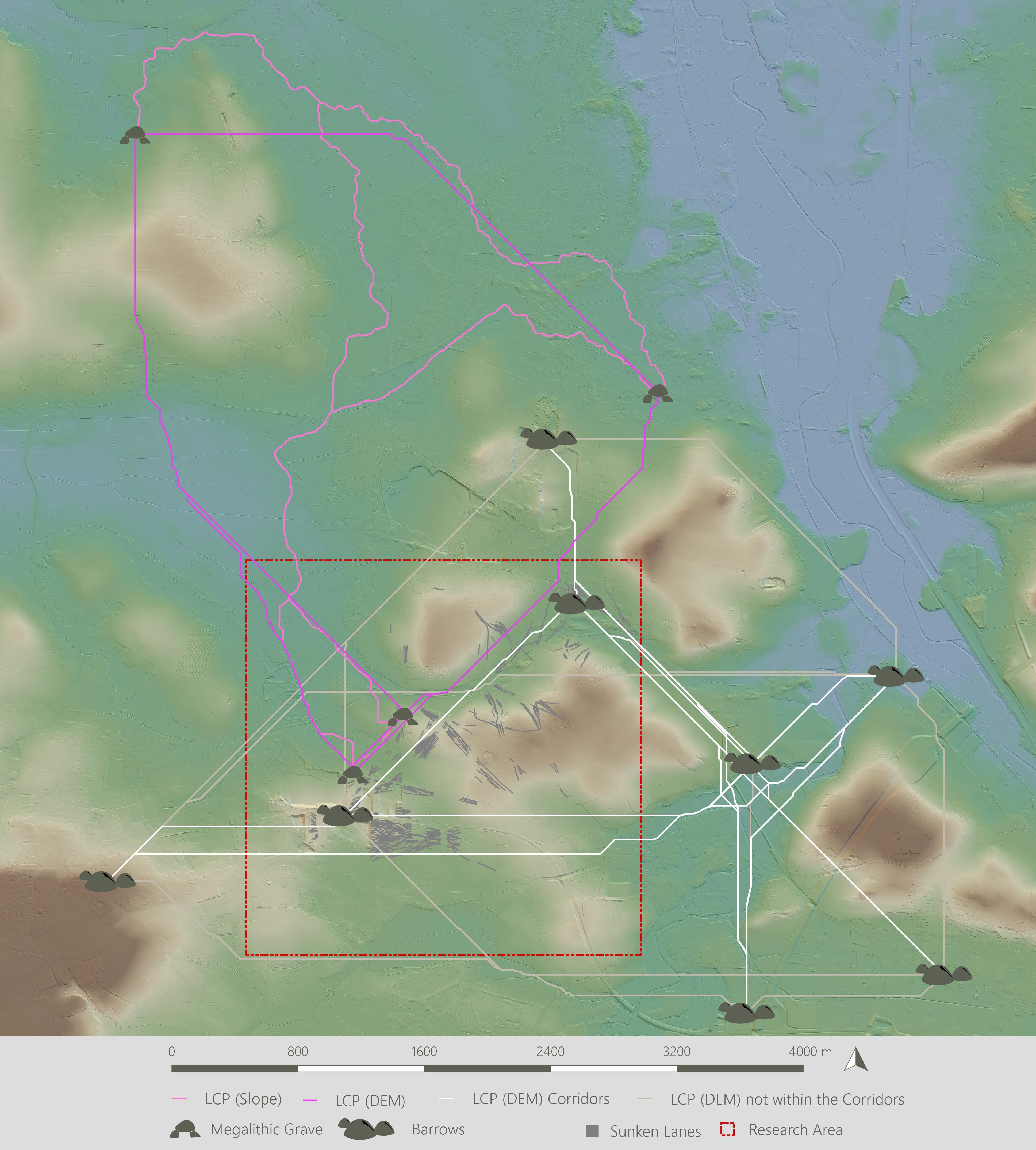
Traces of this cultural landscape development can also be documented archaeologically, as in the Late Neolithic large erratic boulders displaced during the Ice Age were cleared from the landscape to create more arable land (Müller 2011, 19; Rosenstock et al. 2019, 1099, 1108). At the same time, these erratic boulders were seen as a resource as building material from which megalithic graves were constructed. Around these megalithic graves, individual settlement areas could be identified on the basis of visibility analyses. These settlement areas were separated from each other and to a certain degree independent. However, typical regional pottery decorations demonstrate exchange between the individual settlements and least-cost path studies suggest that the Late Neolithic path system was only small-scale and regional. Nevertheless, successive exchanges in both material and ideas took place, as well as a targeted and untargeted dispersal of various plant species (Figure 4).
The fusion of the archaeological, archaeobotanical and soil data now shows that the megalithic graves were placed within the settlement areas in zones of that were originally heathland (Figure 4), on landscape areas with poor vegetation. However, these had only been opened up owing to human use in the course of increasing livestock farming. Indirectly and unintentionally, therefore, people first transformed the landscape before they then responded architecturally to these landscape changes by building the megalithic graves. The megalithic grave Große Sloopsteene was visible on the skyline and as a consequence seen from the Late Neolithic activity zones of daily life.
On the other hand, the investigations showed that this megalithic grave also related to a natural geological phenomenon: a sinkhole that probably occurred close in time to the construction of the Late Neolithic grave may have been interpreted as a supernatural phenomenon. However, the architecture did not directly include the geological phenomenon, but merely referred to it. It can be seen that the prehistoric population was inspired by this natural feature, but at the same time they remained anchored in their socio-cultural thoughts and experiences and built a typical monument of the Funnel Beaker West Group.
In the following Metal Ages (End of Neolithic, Bronze Age and Iron Age), the former rather local and regional path networks were replaced by supra-regional connections (Figure 5). The new routes at this time period now no longer ran directly along the line of the megalithic graves, but followed other routes that evolved into communication corridors over time. Although the Metal Age barrows were located along these new communication routes and therefore used completely different landscape areas than the Neolithic necropolises, mostly there were still visual references to the older megalithic graves. Since in this time slice the landscape had opened up as a result of the former slash-and-burn and human activity (Klinke and Stapel 2021), the finding of two contemporaneous Early to Middle Iron Age barrow cemeteries is striking. These were in line of sight and were not delimited by any natural factors, but appear to belong to two different burial customs – one group buried in square trench monuments and another group whose dead were buried in family barrows. The connection of both to the same supra-regional traffic and communication routes and visible from each other at a distance of less than 1.5km would have allowed social and ideational acculturation. However, the study demonstrates a regional subdivision and landscape structuring through socio-cultural distinction and negates a mutual influence for this time slice.
It is particularly striking that within the Iron Age settlement areas, there did not appear to be intervisibility between the barrows and the arable parcels of the first expansion phase of the Celtic Fields. Thus, at this time, the everyday world was visually separate from the communication routes and the world of transit.
The fact that the vegetation transformed into a heathland in the course of the Middle Ages is evidenced by podzolisations preserved in the mounds of the barrows (Günther 1968).
Another important set of data for the archaeological interpretation of landscapes are the dominant tree species, since perception of landscape distances according to Tadahiko Higuchi (1983) are regularly discussed in landscape archaeology (Murrieta-Flores 2012, 318; Doneus 2013, 3016). For the dominant vegetation of northern Westphalia, however, the parameters developed in Japan seem to be only very rough guide values. The calculation formula seems to work much better with monument heights. Based on this, it was possible to calculate near, middle and long perceptual distances of the specific past landscapes.
In the heathlands, which were now opened up to a maximum in the late Middle Ages, a Landwehr-like triple rampart section was erected in the study area between 1397 and 1399 by the people of Westerkappeln, probably with the connivance of the Count of Tecklenburg. Since this barrier monument is located almost exactly in the area of the Iron Age boundary, it seems that this previously invisible boundary became a physical one by the late Middle Ages. In a subsequent expansion phase of this monument, which can be synchronised with the erection of a customs post in Wersen in 1601 by Count Arnold II of Bentheim-Tecklenburg, the barrier monument was expanded into a complex, multi-levelled rampart-ditch complex. Consequently, from the late Middle Ages onwards, the barrier monument formed an inescapable element influencing and constituting the perception of the landscape, culminating in a spatial landscape stage-set. In both phases of expansion, the monument's imposing construction proves that it was located in a comparatively open landscape and was already shaping the landscape by being visible from a great distance. In addition to the physical representation of the administrative boundary between the parishes of Westerkappeln and Wersen, in the first construction phase the late medieval Landwehr-like section also provided practical protection for the settlements and the farmed areas behind it, which implicitly refers to the agricultural use and livestock farming of the late medieval population. Archaeological relics of this everyday use and of the pragmatic structuring of the cultural landscape can be found in the study area, represented by ridge and furrows and the enclosed limestone hilltop of the Werser Holz that was used as a feedlot.
It is evident that from the Late Neolithic onwards, the cultural landscape was already constituted around a geological phenomenon to create a sacred landscape, which then lasted for at least three millennia when it then became more secular in the Middle Ages. The new absolute dating has made it possible to synchronise the changes in the natural environment with changes in the anthropogenic material-cultural traces in the study area. This revealed the continuous, conscious but also unconscious influence of humans on their surrounding environment. Based on the newly developed method, the study area shows that the change in biodiversity is no longer documented exclusively in the off-site pollen data, but can now also be read from the anthropogenic archaeological relics.
This study was funded by the German Academic Scholarship Foundation and supported by the University of Münster, the LWL-Archaeology for Westphalia and the Altertumskommission für Westfalen.
Internet Archaeology is an open access journal based in the Department of Archaeology, University of York. Except where otherwise noted, content from this work may be used under the terms of the Creative Commons Attribution 3.0 (CC BY) Unported licence, which permits unrestricted use, distribution, and reproduction in any medium, provided that attribution to the author(s), the title of the work, the Internet Archaeology journal and the relevant URL/DOI are given.
Terms and Conditions | Legal Statements | Privacy Policy | Cookies Policy | Citing Internet Archaeology
Internet Archaeology content is preserved for the long term with the Archaeology Data Service (ROR). Help sustain and support open access publication by donating to our Open Access Archaeology Fund.
 Home
Home