Cite this as: Novák, D., Oniszczuk, A. and Gumbert, B. 2023 Digital Archaeological Archiving Policies and Practice in Europe: the EAC call for action, Internet Archaeology 63. https://doi.org/10.11141/ia.63.7
The preservation of archaeological data through digital archiving is a long-standing need, which is being addressed in theoretical and practical terms. Although it may be assumed that the digital transition of archaeology is nearly complete, it is essential to question whether this is accurate when the primary output of archaeological fieldwork is the archaeological archive, including documentary materials. In recent years, there have been a variety of European initiatives focused on digital archiving and working with the archaeological digital record. We can examine two of the most significant examples: the ARIADNE and SEADDA projects.
The ARIADNE (Advanced Research Infrastructure for Archaeological Data Networking in Europe) research infrastructure aims to combine existing archaeological data from different countries using shared standards and ontologies, creating a unified web portal and offering a broad range of digital services. SEADDA (Saving European Archaeology from the Digital Dark Age) project brings together partners to enhance the FAIRness (Findability, Accessibility, Interoperability, and Reusability) of data and shares best practices for building data repositories. However, while both projects have accomplished several achievements, they have been challenged by the uneven readiness of individual partners (and the countries they represent) to contribute to a common outcome. The two consortia have a strong intersection of dozens of partners, comprehensive coverage of relevant European countries, and extra-European overlaps, allowing for global comparisons.
The implementation of the project plans has not so far been limited by theoretical, methodological, or technical issues, where archaeology has made considerable progress in recent years, taking advantage of the latest developments. Instead, the limitations are mainly practical, with the digital transition being incomplete in several countries, impacting certain areas, and facing inadequate systemic support.
Our article aims to provide an accurate representation of the current state of archaeological digitisation in Europe and to identify concrete steps that can be taken to improve the field as a whole, rather than just its most visible and internationally presented apex. It also seeks to establish a solid foundation for developing a set of recommendations for key stakeholders who establish national rules for the care of archaeological heritage, of which archaeological data is an integral part. We advocate for action and provide strong arguments in support of placing a higher value on the importance of data preservation.
The Valletta Convention was adopted in 1992, before the emergence of digital and internet solutions, which are not addressed therefore. However, a doctrinal framework that can support the case for digital archaeology already exists. In 2003 UNESCO adopted the Charter on the Preservation of Digital Heritage, which recognises the existence of digital heritage, whose 'lasting value and significance' should 'be protected and preserved for current and future generations' (Article 1). The purpose of preserving digital heritage is to ensure public accessibility (Article 2). The charter emphasises the need for action: 'To preserve digital heritage, measures will need to be taken throughout the digital information life cycle, from creation to access. Long-term preservation of digital heritage begins with the design of reliable systems and procedures which will produce authentic and stable digital objects.' (Article 5). In the two decades that followed, some of the measures specified in the charter were implemented. However, archaeological archives have been left behind, partly because they exist at the intersection of multiple domains, including heritage management, science, administration, and archiving. To be accessible and fully reusable, they require more attention than other digital resources.
Infrastructures for spatial information in public institutions were established across the European Union after the adoption of the INSPIRE directive, which aimed to facilitate informed environmental policy making (European Union 2007). However, this directive did not sufficiently address the needs of digital archaeological archives, which encompass a much broader scope of data than site location and basic metadata. Despite this, the implementation of the directive has ensured that each member state of the EU has a minimum spatial infrastructure that archaeological heritage managers can utilise as a foundation for further improvements.
The Council of Europe (CoE) recognised the right of everyone to benefit from cultural heritage and to contribute to its enrichment, while also acknowledging the responsibility to respect the heritage of others, in its Framework Convention on the Value of Cultural Heritage for Society (CETS No. 199, Article 4, 2005). The convention also emphasised the need to utilise digital technology to enhance access to cultural heritage and called for the exchange of information and internationally compatible standards (Article 14). The CoE's recommendations on the internet of citizens (CM/Rec(2016)2), cultural Big Data (CM/Rec(2017)8), and the internet as an emancipatory force (CM/Rec(2018)10) addressed more specific topics. These recommendations advocate for the development of strategies, policies, legal frameworks, and institutional frameworks to preserve the digital heritage of lasting cultural, scientific, or other value, as well as to assist cultural entities in archiving data for public interest and ensuring public access to these data (CM/Rec(2017)8, 6–9). The CoE calls 'to promote and facilitate the search for diverse pluralistic information and knowledge' with the use of 'open-source tools, commons and related open working methodologies for cultural and research activities by citizens and by the public sector and public service actors and institutions' (CM/Rec (2018)10, Appendix 1, 7–8).
Despite the existence of international conventions and the need to share experiences and enhance the quality of data and repositories, the development of digital technologies in archaeology is not adequately reflected in the organisational, legislative, and political levels of individual countries. This results in an imbalance that limits the impact of emerging digital technologies in archaeology as a whole. While some parts of archaeology and institutions focused on scientific excellence are keeping up with the development, the primary focus of archaeology still lies in the management and research of archaeological heritage at a local level, which is operated by regional museums or commercial archaeologists. This work generates most of the primary data in archaeology, which is largely obtained through destructive methods and is non-reproducible and irreplaceable. However, the impact of digitisation on this level of archaeological work has been limited.
The practice of digital archiving of archaeological data has been the subject of attention from both the Working Group for Archaeological Archives of the European Archaeological Council (EAC) and the SEADDA project. In a special issue of Internet Archaeology, the two entities brought together articles on digital archiving from more than two dozen countries (Richards et al. 2021). Following discussions held in the spring of 2022, EAC and SEADDA found that there are common challenges faced by those dealing with documentary archives worldwide, as well as examples of good practices. The articles emphasised that:
To complement the published studies with additional data that covers the entire European region, a questionnaire survey was conducted. The survey allowed for a cross-sectional analysis of the state of digitisation in the field and an international or inter-regional comparison. One important aspect covered in the questionnaire was the approach to archaeological archiving and the identification of digital archaeological resources to be archived in each country. The analysis of published papers has revealed that the process of archaeological archiving in many countries does not always lead to the creation of an archaeological archive in the strictest sense, as defined by Perrin et al. (2014 20). In many countries, archiving is limited to the fieldwork report, which is typically a PDF document. While this approach was more appropriate in the analogue world and to smaller interventions, where fieldwork reports represented a compilation of annotated and sorted primary documentation in its original analogue format, in digital archiving it results in the degradation of the original record and lowers the data FAIRness. The actual implementation of the FAIR principles is a complex topic that places requirements on both data creators and repositories (see section 6 in Geser et al. 2022 for a summary).
Therefore, in the survey, we used the following definitions to distinguish between primary and secondary data, as it corresponds to the division within the observed practice:
We then required responses to most of the questions in the survey for each of these data categories separately to assess whether there are any significant differences in their treatment.
The questionnaire, along with the full responses and their statistical summary, is available from Zenodo: https://doi.org/10.5281/zenodo.7656838
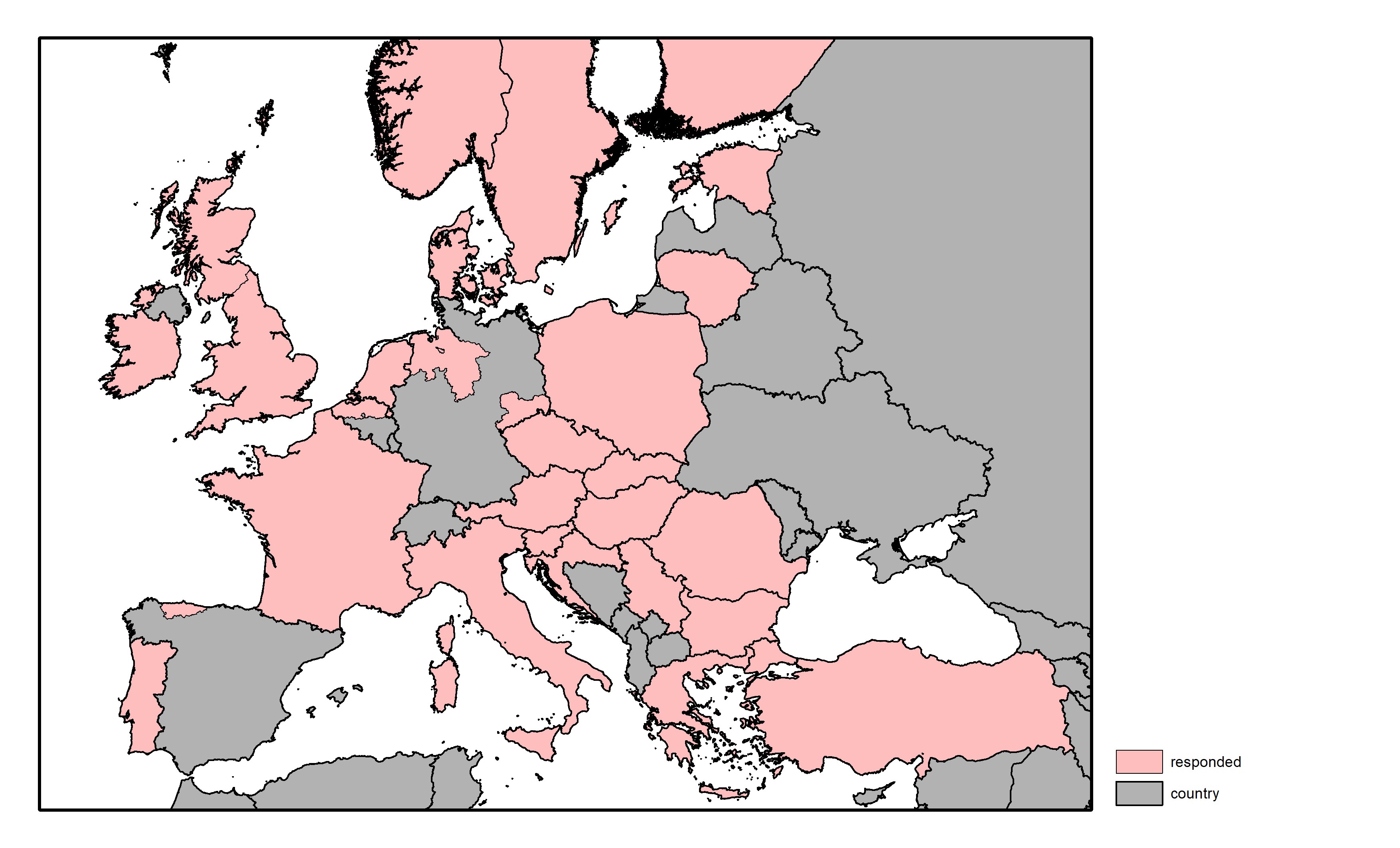
A total of 33 European countries, predominantly SEADDA Cost Action members, were directly contacted for their response to evaluate the state of digital archiving and heritage data management at a country or state/regional level, in the case of federal countries with a high level of regional autonomy. In total, 31 responses were received, which allowed for an overview of the situation in 27 countries (see Fig. 1), namely: Austria, Belgium, Bulgaria, Croatia, Czechia, Denmark, Estonia, Finland, France, Germany, Greece, Hungary, Ireland, Italy, Lithuania, Netherlands, Norway, Poland, Portugal, Romania, Serbia, Slovakia, Slovenia, Spain, Sweden, Turkey, and the United Kingdom. Additionally, responses were received for specific states or regions, namely: Flanders (BE), Bremen, Lower Saxony, and Saxony (DE), Asturias (ES), and England and Scotland (GB). Notably, Austria had two separate responses, which presented different perspectives from respondents involved in heritage management versus academia, thus requiring consultation with respondents to generate a single answer for the country that would be more comparable with other data.
All respondents were selected as experts in digital archiving and/or heritage data management for their respective countries. The responses were based on expert opinions, sometimes supported by published materials, national regulations, and local survey data. The survey covered samples of all European regions, making the data highly representative, except for Germany and Spain, where a limited number of federal states were covered, and therefore it is questionable how representative the data for these countries may be. Answers were mandatory to all questions, except for supplementary comments. In the subsequent sections, we provide a summary of the responses to each question.
The prevailing European legal standards predominantly focus on defining a fieldwork report (87%), with comparatively lesser emphasis on fieldwork data (60%). Notably, secondary data is mentioned in the standards of only 33% of countries, which is commensurate with the non-digitised approach that is suited to the fieldwork report form. This indicates that significant efforts are required to adapt the standards to the digital transition. The discrepancy in the treatment of secondary data is not unexpected, given the rudimentary state of scientific data management regulations. It is further observed that the regulatory solutions for secondary data do not coincide with the coverage of fieldwork outputs, where all countries with a data definition also provide a definition for a report (Figs 2–4).


In terms of setting standards for fieldwork reporting, a comparable situation to the first question is observed. A formal reporting standard exists in 73% of countries, with an additional 23% adhering to at least informal standards. Turkey is the only country without any reporting regulations. The standardisation of fieldwork data is somewhat less satisfactory, with 47% of countries having formalised standards and 43% relying on informal rules. For secondary data, only 17% of countries, including Flanders, Saxony, England, Portugal, and the Netherlands, apply formal standards. It is worth noting that in some cases, such as Saxony, it is uncertain whether respondents fully understood the scope of secondary data. An additional 27% of countries adhere to informal standards for this area (see Figs 5–7).


The extent of digitisation in the field is apparent from the percentage of fieldwork reports that are primarily delivered in digital format, which is the case for the vast majority of countries (97%; see Fig. 9). However, the production of fieldwork data in digital form is less prevalent. While digital versions predominate in 90% of cases, only 33% of countries claim complete digitisation, compared to 70% for reports (see Fig. 8). Consequently, digitisation is frequently performed later, during data processing, as data are not typically born-digital. The situation for secondary data is comparable to that of primary data (see Fig. 10).


In the context of digitisation, a similar situation can be observed for legacy data. According to statistics, the majority of reports have been digitised in many countries, with less than half of collections remaining analogue only in 63% of these countries; more than 95% of reports have been digitised in one-third of these countries (see Fig. 12). Fieldwork data have the lowest proportion of digitised collections, with exactly half of the countries indicating that digitisation rates are less than 50% of the existing archives (see Fig. 11). In terms of secondary data, historical archives are predominantly digital in 67% of countries (see Fig. 13). A comparison of responses to questions 3 and 4 is available as Figure 14.


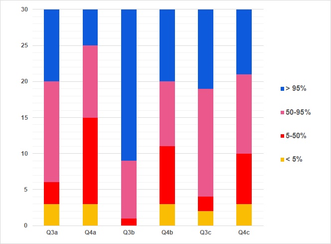
The mere existence of digitisation does not guarantee the availability of data online, although this is the ultimate goal. These findings are consistent with the results obtained from the study, which reveal that fieldwork reports are the most frequently published, but in only a third of countries are they available online (see Fig. 16). Moreover, fieldwork data is available in less than half of the total volume in the vast majority of cases (86%), with 63% of countries reporting availability of less than 5% (see Fig. 15), which is a cause for concern. Similar unsatisfactory outcomes are observed for secondary data, with all surveyed countries reporting availability below 50% (see Fig. 17).


If we disregard the issue of online accessibility of data and reports, it is possible to observe their findability through open data catalogues and indexes. However, the indexing of data remains a challenge in many countries, with only 67% indexing fieldwork reports. Furthermore, the accessibility of catalogues remains a concern, with only 27% being fully open to the public and an equal proportion having variable accessibility (Fig. 19). Fieldwork data is only indexed in 37% of countries and rather non-publicly (Fig. 18); secondary data is catalogued by the same number of European countries (Fig. 20). As a result, our knowledge of data sources and archaeological documentary archives is fragmented, which not only affects archaeological practice but also impacts the accuracy of the survey results.


The unsatisfactory level of digitisation and data availability can be attributed, in part, to the lack of reliable digital repositories at a national level. Approximately one-third of countries store fieldwork data in central repositories, whereas half of the countries store reports, and a mere 17% store secondary data. With respect to regional repositories, they constitute a minor share in all three cases, although they play a role in Norway and, to a lesser extent, in Flanders. Nevertheless, a significant proportion of institutional repositories exist, which likely compensates for the lack of central storage. At the institutional level, secondary data is the most commonly stored (37%), followed by fieldwork data (23%) and reports (17%). The findings indicate that the vast majority of data is stored improperly, outside of trusted repositories (see Figs 21–23).


The storage of fieldwork data in digital repositories is a requirement in 43% of countries, with Saxony additionally mandating the archiving of analogue versions (see Fig. 24). Notably, 63% of cases require fieldwork reports to be archived digitally, while only 10% require analogue copies (see Fig. 25). Regarding secondary data, archiving is mandatory in 23% of countries, always in digital format (see Fig. 26). However, when comparing these findings with the actual availability of repositories (as per question 7), it becomes apparent that the reality falls short of both best practices and administrative requirements. This interpretation of the results was confirmed by comments from respondents in Poland, Serbia, and Sweden.


The survey also examined the perceived qualitative features of digital repositories currently in use for archaeological data. Table 1 and Figures 27–33 provide a summary of the collected data. The findings reveal that nine countries, namely Asturias, Croatia, Denmark, Greece, Italy, Poland, Slovakia, Sweden, and Turkey, were rated as mostly unsatisfactory. In 11 other cases (Austria, Bremen, Estonia, Finland, France, Lithuania, Lower Saxony, Portugal, Scotland, Serbia, and Slovenia), the situation was found to be slightly better but still ambiguous. On average, the situation was considered acceptable by eight respondents from Bulgaria, Czechia, England, Flanders, Hungary, Ireland, Norway, and Saxony. The Netherlands received a rating of perfect and, surprisingly, so did Romania, which requires further verification owing to the lack of published review articles (Richards et al. 2021). The results for individual qualitative traits were generally normally distributed, with a tendency towards 'unsatisfactory' and 'acceptable' options, particularly for user support and interfaces. This trend may be attributed to the general availability of systematically developed digital repositories.
| Q9 | Unsatisfactory | Ambiguous | Acceptable | Perfect |
|---|---|---|---|---|
| Availability | 37% | 20% | 33% | 10% |
| Storage capacity | 27% | 20% | 33% | 20% |
| Guidelines and workflows | 33% | 33% | 30% | 3% |
| User support | 43% | 13% | 40% | 3% |
| User interface | 37% | 17% | 43% | 3% |
| Quality monitoring | 33% | 30% | 27% | 10% |
| Sustainability | 37% | 27% | 30% | 7% |


The FAIRness of data in different countries can be assessed based on the extent to which various aspects of FAIR data are fulfilled for different categories of data. Notably, fieldwork reports were found to have a comparatively high level of findability (60%) and accessibility (57%), but lower levels of interoperability and reusability (both at 27%). However, both findability (33% for fieldwork and 37% for secondary data) and accessibility (13% for both) were found to be significantly lower for fieldwork and secondary data. While 17% of countries achieved interoperability for fieldwork data, none were identified as being truly reusable. Similarly, only 10% of countries met the interoperability and reusability attributes for secondary data (Figs 34–36). It should be noted that the actual situation is much more complex than the binary yes/no answers provided in this question. Nevertheless, the data obtained reveal some general trends that are consistent with the findings for other questions.


The introduction of Data Management Plans (DMPs) is increasingly being utilised as a preferred planning tool for the management of digital research data. However, it appears that this approach is not widely known in the cultural heritage sector. In terms of legal requirements, DMPs are mandatory only for fieldwork reports in 20% of countries, for fieldwork data in two countries (Flanders and Norway), and for secondary data in Saxony. In 20% of countries, DMPs are utilised solely based on funding sources, irrespective of the type of data. Furthermore, in some countries, DMPs are recommended for specific types of data (ranging from 13% to 23%), and in Slovakia and Turkey, DMPs are planned to be implemented for managing secondary data (as shown in Figs 37–39).


Archaeological heritage is predominantly safeguarded by both international and national legislation. However, the protection of archaeological data, which should be regarded as an integral part of the invaluable cultural heritage, is often overlooked in such legal provisions. Fieldwork reports, fieldwork data, and secondary data are formally recognised as heritage in 33%, 27%, and 20% of countries, respectively. In another 27% of cases, reports receive some form of protection that is not mandated by law, while 20% and 30% of countries apply similar protection to fieldwork data and secondary data, respectively. Consequently, only 47–60% of countries provide comprehensive protection of their archaeological heritage (Figs 40–42). This represents a significant loophole in the current administrative policy, which runs counter to the public interest.


Based on the data collected, it can be inferred that the funding scheme adopted by most countries involves repositories covering the long-term preservation costs, with percentages ranging from 37 to 67% depending on the type of data. Conversely, some countries place the responsibility on the data provider, with percentages ranging from 13 to 23%. However, a considerable number of countries (ranging from 20 to 40%) have an undefined situation, which is not ideal as it creates room for the issue to be ignored. This is shown in Figures 43–45.


Data archiving is a crucial aspect that is always linked with appropriate copyright laws as it has a significant impact on the ability to handle data in the future. The ownership of copyright is primarily attributed to the provider or the repository, with approximately 23–30% of countries assigning copyright to the former and 13% of countries assigning it to the latter. In some cases, both primary and secondary data are shared under open licences in 13% of countries, and fieldwork reports in 23% of cases. Third-party ownership of copyright is a rare occurrence and is only applied in a few countries such as Finland, Flanders, and Lower Saxony. However, in many countries, the situation regarding copyright ownership is either variable (17–23%) or not addressed at all (10–23%), as shown in Figures 46–48.


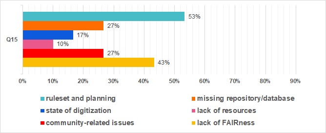
In our survey, we utilised an open-ended question to enquire about the most significant limitations to the reuse of archaeological data. We present a detailed overview of the responses in Figures 49–54; however, we urge readers to refer to the full-text responses to avoid possible interpretative biases. The results presented here are a summary of the textual answers to facilitate evaluation, which might obscure certain national traits. Nonetheless, we were surprised by the strong correlation in content from all respondents. Overall, the primary barriers described by respondents are related to administrative regulations, standards, and planning, identified in 53% of countries. This category can be further subdivided into issues such as standards (17%), copyright and ownership (13%), official policies (13%), and prevalent reporting, looting prevention, and planning for archiving (two countries each). The second most commonly cited group consists of FAIRness issues in general, with significant shortcomings named in 43% of countries. This group can be further subdivided into issues related to findability (17%), accessibility (23%), interoperability (17%), and overall lack of adherence to FAIR principles (13%). The third most frequently cited barriers are the lack of a central repository or database and community-related issues, both reported by 27% of countries. The latter can be broken down into lack of skills (13%) and lack of awareness or willingness (17%). Insufficient digitisation is a concern for 17% of countries, while lack of resources in general is a problem for 10%.


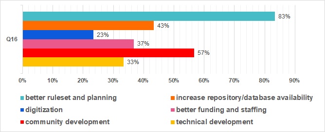
In a similar manner to the preceding case, respondents were asked to identify the most significant steps required to enhance the present state of archaeological digital archiving. The majority of respondents/countries (83%) deemed it essential to improve the regulations and planning processes, with the application of standards viewed as necessary by 50% of the countries. Legislative interventions were considered necessary by 43% of respondents, and 23% identified a need for mandatory open access by default. Improved planning was cited by 20% of the responses, and better control mechanisms were deemed necessary by 13% of the countries. The second most frequently identified action was community engagement, identified by 57% of countries, with 40% emphasising training and 27% focusing on awareness-raising. Collaboration was viewed as crucial by 13% of countries. Increasing the availability of repositories or databases (43%), including central indexes (20%) or data repositories (33%), was also seen as necessary. Respondents also felt that there is a need to increase funding and improve staffing (37% of countries), with related technical development needs identified by 33% of respondents, including infrastructure (20%) and user interfaces (17%). The last frequently mentioned issue was the need for advancements in data digitisation (23% of countries). It is worth noting that there was a strong consensus among the full-text responses, highlighting shared and Europe-wide shortcomings in the management of digital archaeological heritage.


To facilitate a comprehensive discussion on the results of the questionnaire survey, it is essential to establish a conceptual framework. This framework is constructed from shared best practices, the current mission of the discipline of archaeology, and informed consultations among members of the EAC Working Group for Archaeological Archives.
The starting point of this framework is the recognition that sites in the landscape, including archaeological finds and contexts in their original locations, represent the sole direct source of primary archaeological data. It is widely agreed that the main focus of archaeological heritage management should be on the preservation and investigation of these sites, without direct destructive intervention. This approach is driven by the understanding that intentional or unintentional intrusions into archaeological sites are destructive and necessitate the creation of archaeological archives to replace disappearing heritage. Intervention is usually necessary owing to loss caused by human activity (e.g. building development), environmental change, such as erosion or water-table change, or intervention to ensure the understanding of the site. The primary objective of archaeological preservation is to minimise the loss of archaeological heritage and to conserve as much information as possible.
The excavation of archaeological sites, which involves the controlled destruction of their material form, is only justified if the site is excavated and documented thoroughly in accordance with current archaeological methodology and in line with its significance, and if the resulting archive is going to be preserved. Because archaeological excavation is a non-repeatable event, the archaeological documentation is the only surviving record of the now-destroyed or damaged site. This also applies to finds and samples processed in destructive post-excavation analyses or to de-selected finds (see Oniszczuk et al. 2021). As such, the archaeological heritage consists of three components: sites, recovered finds, and documentary archives, together forming an indivisible complex in which the still-existing sites are gradually converted into the remaining two components. In the context of archaeology, primary documentation is a direct constituent of cultural heritage, rather than an addition to it. It is this that makes the primary data so important, and why their preservation and accessibility are prioritised in the survey and the following recommendations.
When it comes to heritage values and workflows, it is immaterial whether the documentation is created in analogue or digital form. Public expectation and modern approaches to heritage management necessitate a full digital transition. Consequently, the criteria for creating, preserving, and providing access to documentary archives in archaeology are universal and involve digitising relevant analogue materials. The born-digital archives should be considered the primary form of documentation and the analogue should be digitised in such a way as to match them as closely as possible, enhancing accessibility and providing security, although this is a goal that can only be achieved in the long term.
Upon analysing the survey results, several recurring deficiencies in current practice have been identified. One of the main issues is the lack of recognition in legislation and regulations for the heritage value of archaeological data, regardless of their analogue or digital format. Typically, only the physical components of archaeological heritage, such as sites and artefacts, are subject to targeted protection and recording. Unfortunately, documentation is often disregarded or does not receive the same level of attention as sites and finds under heritage legislation. Additionally, procedural steps concerning the creation, storage, and accessibility of such data are often undefined in many countries. Overall, regulations for these steps are scarce and their quality is not adequately monitored or enforced.
Consequently, the preservation of archaeological data is left to the discretion of various stakeholders. This approach has detrimental effects on heritage management and the scientific discipline of archaeology. Firstly, the full cost of archaeological documentation, post-excavation study, and preservation are not taken into account adequately in funding for research, museums, conservation, and other concerned organisations. As a result, an unclear or widely dispersed system of responsibilities leads to inefficiency and a shortage of competent staff and resources for the proper care of archaeological data. Additionally, the interests of creators and custodians of archaeological documentation often take precedence over public interests and heritage management objectives. This is partially due to problems with the personal motivation and commercialisation of archaeology, but it is also a result of compromises forced by institutional staffing and budgeting.
As evident from the responses, fieldwork reports are often used in place of data archiving. However, such reports only provide supplementary information for interpreting fieldwork data and lack a solid evidential basis, rendering their interpretations non-scientifically verifiable. Furthermore, complete documentary archives are often dispersed and stored in unknown locations, where proper security and sustainability measures are not implemented. In many countries or regions, the lack of a centralised online catalogue of archaeological documentation makes it impossible to trace and reuse such data. This dispersal may result in the loss of proper linkage to material elements of the collected archives. Last, but not least, even in countries where data is relatively accessible, interoperability and reusability are often lacking owing to the inadequate management of data by staff who possess insufficient disciplinary knowledge.
The preservation of digital archaeological data presents a particular set of challenges owing to their advanced nature and associated costs. The SEADDA thematic issue of Internet Archaeology highlights the underfunding of digital archaeological archiving, a concern expressed by all contributing authors (Richards et al. 2021). The legal and administrative procedures in place do not always reflect the progress made in this field, and organisations responsible for the archives may lack the necessary knowledge and resources to manage them adequately. Consequently, cultural heritage is at risk of complete and uncontrolled destruction. Unlike other research fields, digital archaeological archiving is typically not grant-funded because of the 'polluter pays' principle, and although measures like DMPs and FAIR data management are available, they are not consistently enforced. Access to documentation is often restricted for organisational, financial, or individual reasons, which can limit data sharing and reuse. Copyright and ownership regulations may hinder these activities, although some countries have waived these provisions to facilitate heritage management.
In European practice, it is apparent that the long-term preservation of archaeological digital data is not assured in the absence of laws that guarantee their preservation, whether they are derived from fieldwork or secondary sources. The archiving process is highly intricate, particularly in the case of digital assets, and completely decentralised systems that lack sufficient control and organisational stability are unlikely to be reliable. Similar to the preservation of material archaeological remains, preserving the heritage value of documentary archives requires sustainability, which can be provided by central solutions that are supported and administered by national or regional governments (in federal countries) or their agencies.
As stated in the introduction, and strongly supported by the survey results, the challenge faced by archaeology is not its ability to adapt to technological advancements. Instead, the root causes of the difficulties encountered in data archiving lie in broader organisational and legal issues, which create unsustainable conditions for the management of archaeological heritage. The current definition of cultural monuments, which focuses exclusively on the material component, creates a misconception that preserving the physical sites and finds alone will yield satisfactory outcomes. However, the preservation of these elements alone without adequate archaeological documentation would result in an incomplete representation of the historical landscape.
The authors propose a set of crucial changes in conceptual, practical, and organisational terms to address the current challenges. These recommendations will soon be translated into a clear set of recommendations for decision-makers, including national legislators and senior management of heritage and archaeological organisations, which will be disseminated by the EAC. It is essential to take concerted actions to implement these recommendations to prevent the loss of shared cultural heritage.
Archaeological data can be sourced from different channels and may vary in nature. The present study employed a questionnaire that involved three levels of concepts, namely fieldwork data, fieldwork reports, and secondary data (see section 2). To establish fundamental principles, this preliminary terminology requires clarification.
The primary documentary archives constitute the basic specificity of archaeology. They consist of: (i) the documentation of contexts and sites dismantled during fieldwork, (ii) the documentation of analysed finds and samples, especially those damaged or destroyed during analysis, (iii) the documentation of de-selected finds or samples, (iv) the post-processing data that is indispensable for interpretation or cannot be replicated, and (v) the final report (as set by national, regional or local standards and regulations). The primary documentary archive forms the core of the project documentary archive, which also includes other accompanying or derived documentation. Although preserving all the archaeological data is an ultimate goal, the primary archive is wholly exceptional and therefore has its irreplaceable heritage value. When digitised, documentary archives take the form of digital archaeological archives.
Other types of archaeological data that stem from the reuse of archaeological archives, as well as from other sources, can be regarded as secondary data. The creation of such data is linked to research procedures that are usually repeatable. The nature of such data does not differ from research data in other scientific fields; therefore this article does not deal with this topic further.
On such a terminological basis, this section presents a set of five guiding principles aimed at effectively managing primary documentary archives. The principles were first drafted during the SEADDA workshop in May 2022 in Braga and were finalised by the EAC Working Group for Archaeological Archives. They are as follows:
These guiding principles provide a framework for archiving archaeological data and ensure their transparency, preservation, and reusability. The following section provides a set of basic practical measures necessary to fulfil these aims.
Archaeological documentation is a principal component of archaeological research as it captures and documents the results and interpretations of fieldwork events. It is imperative that all documentation is created, preserved, and disseminated in compliance with established standards to ensure the accuracy, completeness, and accessibility of the information for future research and other reuse. Archaeological documentation may be available in various forms, including digital data. The choice of documentation depends on the particular requirements of the project, as well as the available technology and resources. At present, however, digital solutions should always be prioritised.
Preserving documentation is equally critical as its creation, as it guarantees that the information is not lost over time. This necessitates using appropriate storage techniques to safeguard the documentation from damage or degradation, such as climate-controlled environments and digital backup systems. It also entails implementing protocols to ensure proper handling and monitoring throughout the entire data lifecycle. Adhering to established standards is critical not only for advancing research, promoting transparency and building trust, but also for protection and preservation. As a result, it is critical that compliance with these standards is required by law.
Legislation can establish a framework for ensuring that archaeological documentation is created, preserved, and disseminated properly. It can stipulate the type of documents that must be created, the preservation methods that must be used, and how the documentation must be disseminated. It can also ensure that adherence to established standards is monitored and enforced when necessary and that researchers, students, and other interested parties have access to primary documentary archives.
To ensure accuracy, consistency, and reliability, documentation must adhere to uniform rules. These rules should cover all aspects of the process, ensuring that data is collected using standardised methods and organised using standardised formats and metadata. Additionally, documentation should be subject to independent validation and control mechanisms to ensure accuracy and freedom from errors and omissions. Creating a documentary archive must be the final step in the process that enables the preservation and accessibility of the data over time.
While creating and archiving data, it is essential to ensure the availability of up-to-date digital tools, quality control measures, digital skills, and professional support. To handle documentary archives effectively, technical, organisational, and individual measures must be taken during all steps of fieldwork, archive compilation, archiving, and long-term preservation. At the onset of the project, a specialised repository should be selected for future archiving, and its rules, standards, and workflows adhered to. Appropriate tools such as specialised software for archaeological data management should be employed during fieldwork. Workers in the field should follow standardised data collection and handling procedures, including the use of rich metadata and standard vocabularies. During archive compilation, organisation and processing, documentation standardised methodology should also be followed. The project team should be professionally equipped to manage the complete archiving process. These measures are set up to secure data completeness and integrity.
The documentation being created (such as paper records, photographs, maps, and drawings) should be digitised during the project so that the digital archive contains everything selected for preservation. Once a digital archive is created and both digitised and born-digital documentation is available and complete, the archive should be made accessible to a wide range of users. This should be achieved using specialised digital repositories that provide open access to the documentation.
Digital documentation plays a crucial role in modern archaeology. However, successful implementation requires careful planning, execution, and maintenance of data and infrastructure. Designing and maintaining a system of digital documentation is a complex effort that is more challenging than organising analogue documentation. The transition from analogue to digital documentation in archaeology involves a series of essential steps to ensure that the resulting digital archives are complete, accessible, and usable. When done correctly, digital documentation can greatly enhance the value and accessibility of archaeological information and facilitate research and public outreach.
It is essential to ensure the long-term survival of digital documentary archives and safeguard them against loss, damage, or degradation. This necessitates the use of appropriate storage media, backup and recovery systems, and management processes that guarantee data remains safe and follows the FAIR principles. Digital archives must be managed by trained staff, who implement regular quality checks and provide depositors with guidance and standards, including appropriate metadata schemas and well-developed shared vocabularies. It is recommended that primary documentary archives are entrusted only to institutions that possess the necessary expertise, resources, and commitment to safeguarding long-term preservation. Such institutions should be specialised archaeological digital repositories, capable of adapting to evolving technologies and standards, which require ongoing support and sustainable funding models to nurture the data they manage and invest in the ongoing development of the tools and the team.
To promote the broader reuse of digital archives, it is crucial to ensure that they are stored in standardised open formats and can be used across multiple platforms and software applications. It is essential to implement easy-to-apply digital workflows that naturally guide archaeologists through the data lifecycle and ensure that all necessary outputs of archaeological projects are archived. If archiving is carried out by several institutions in the country, there must be a central (national), publicly accessible online index of all archived data. Such a digital index should be FAIR by itself, with particular regard to interoperability and the support of automated data exchange. To enhance the accessibility and reuse for various purposes, such as science, heritage management and spatial planning, archaeological digital archives should be integrated with geographic information systems (GIS), which facilitates collaboration and data sharing across different projects, institutions and even domains.
Making archaeological primary archives available to scholars and researchers is an integral part of the research process since it promotes collaboration and encourages the sharing of information. This can be accomplished through various means but, once again, it is essential that the documentation is made accessible and usable by others following established standards. It is important to ensure that all digital archaeological documentation is available online in open access format to promote transparency, collaboration, and research. Maximum openness to the public, who have the right to access cultural heritage, is also essential. Therefore, digital open access to archaeological documentation should be mandatory. Restrictions on access (i.e., embargo periods) should be justified and guided only by national regulations and guidelines related to cultural heritage protection to prevent damage, looting, or unauthorised access to archaeological sites or finds. Additionally, as heritage assets, primary documentary archives should be free from copyright restrictions, making them easily reusable.
An issue of concern pertains to the treatment of the digitisation of legacy archives. The first step in the full digital transition is to record, catalogue and persistently identify all primary documentary archives, regardless of their form, owner, or place of storage, in a central digital index. This system should allow researchers to access documentation easily, notwithstanding its location and format. It should be regularly updated to reflect changes in the available data, and metadata standards should be used to ensure that the data are findable and understandable. The need to ensure the permanence and general accessibility of legacy archives makes digitisation an indispensable preservation goal. However, the digitisation process of historical records necessitates a substantial allocation of resources and, therefore, must be a deliberate and long-term undertaking. Priority must be given based on the evaluation of records in the central digital index.
The creation and preservation of secondary data is a more intricate matter as it is only loosely linked to heritage management. While new research may enrich the heritage value of individual archives, demanding continual updating with new findings is untenable. Nonetheless, disciplinary standards must stipulate that when archives serve as primary data sources, proper citation with their persistent identifiers (PIDs) is crucial. Secondary data must be created, stored, and made available in compliance with relevant Data Management Plans (DMPs) within the framework of FAIR and Open Science principles while preserving links to the primary data.
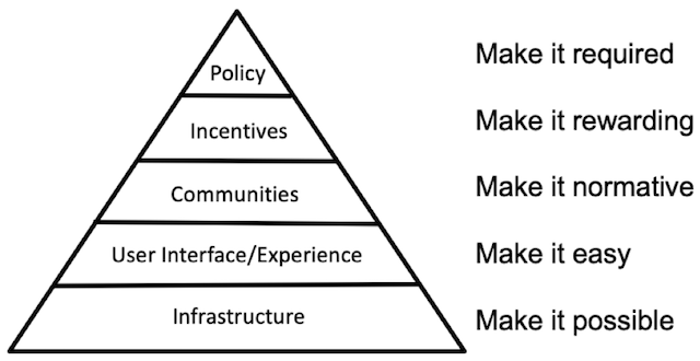
According to Nosek (2019), merely relying on groups of motivated individuals who have made significant contributions to a particular field is insufficient to bring about bottom-up change. Instead, a concerted effort is required to effect a culture shift that is driven by policies and incentives, enabled by adequate infrastructure, facilitated by user experience with well-designed interfaces, and normalised when embraced by the community (see Fig. 63). This is fully confirmed by the survey outcomes, as 83% of countries search for better regulations and processes (see Q16). This section provides a fundamental overview of the crucial changes that the discipline must embrace.
In order to effect a paradigm shift in archaeology, it is imperative to accord equal importance to the protection of all three components of archaeological heritage, namely, sites, finds, and documentation. Accordingly, the legislative and policy frameworks must properly acknowledge the heritage value of primary documentary archives. This requires clearly defining the basic procedures and standards for dealing with archaeological documentation, including digital records, in line with the objectives of archaeological conservation. Furthermore, transparent processes at all levels of the management of documentary archaeological heritage must be established, control mechanisms defined, and responsible authorities equipped with the necessary tools to enforce regulations.
In contrast, regulations concerning digital issues must be flexible in order not to impede technological progress in the field. Instead of maintaining or constructing a dispersed and underfunded network of local data storages, support should be provided for independent, dedicated, and sufficiently strong central repositories at a national or regional level, that can provide stable and long-term infrastructure, knowledge, and staff capacity for the management of archaeological archives. These repositories should be a public service, provided free of charge. Additionally, stable public funding is crucial for organisations responsible for creating and temporarily curating digital archaeological archives, regardless of their research or other activities and legal form, to ensure technical, personnel, and organisational capacity for proper data management.
To tackle these accumulated challenges, digitisation of archaeological heritage management at both the workflow and data level is necessary to improve efficiency and transparency, and overcome the persistent fragmentation or regionalisation of archaeology. Standard solutions at the content and technical level should be encouraged during this process. Finally, all barriers to access to archaeological documentation, particularly organisational and copyright restrictions, should be eliminated.
The EAC is an organisation that works in the field of archaeological heritage management. Its role is to develop general principles and promote an environment, including a legislative framework, that supports sustainable and meaningful archaeology, leading to the highest possible public benefits. A comparison of the practice of digital archiving of archaeological documentation across Europe has revealed shared challenges and good practices that help to overcome these challenges. However, there is a significant disparity in the recognition of the value of archaeological data and their position within heritage management practice. This imbalance affects the level of attention and protection given to archives of (digital) archaeological documentation. To improve this situation, systemic changes are necessary. These changes require political decision-making to provide the resources, a clear framework, and the tools to create a sustainable and meaningful environment for archaeological archiving, leading to the highest possible social benefit. In this article we propose a set of basic principles to handle primary documentary archives and recommend practical changes in archaeological practice, as well as in its legislative and organisational framework. Rather than striving for changes in individual researcher practices, we recommend a top-down approach that focuses on systemic changes. We will continue to advocate for these changes through responsible institutions and call upon the community for support in our efforts. We believe this is the only way to ensure the preservation of irreplaceable archaeological data.
This article received support from the EAC, particularly the Working Group for Archaeological Archives, and the SEADDA Cost Action (CA18128) and its team. We are grateful for the kind cooperation of the survey respondents. The work on the text was supported by the large research infrastructure project Archaeological Information System of the Czech Republic (LM2023031). The DeepL translator and ChatGPT chatbot were used to finalise the language and style. Proofreading was done by Juliane Watson and Claire Tsang.
Internet Archaeology is an open access journal based in the Department of Archaeology, University of York. Except where otherwise noted, content from this work may be used under the terms of the Creative Commons Attribution 3.0 (CC BY) Unported licence, which permits unrestricted use, distribution, and reproduction in any medium, provided that attribution to the author(s), the title of the work, the Internet Archaeology journal and the relevant URL/DOI are given.
Terms and Conditions | Legal Statements | Privacy Policy | Cookies Policy | Citing Internet Archaeology
Internet Archaeology content is preserved for the long term with the Archaeology Data Service (ROR). Help sustain and support open access publication by donating to our Open Access Archaeology Fund.
 Home
Home