Cite this as: Urankar, R., Krajšek, J. and Lipovec, B. 2024 Archaeologists, Hunter-Gatherers of Digital Data, Internet Archaeology 65. https://doi.org/10.11141/ia.65.2
Just as the manufacturing industries are subject to economic laws, so too are archaeological excavations, compelling us to operate more efficiently in terms of time and money. The inevitable optimisation of documentation procedures must not, however, result in a lower quantity or quality of recorded data. In fact, technological advancements have enabled us to excavate and research more quickly while recording significantly more and better data compared to excavations a few decades ago. This in turn means that the standards for all archaeological work, from fieldwork preparations to publishing, should continually be improved. We make the decisions regarding how and to what extent we document certain excavations based on our knowledge, experience, the available technologies, and economic factors. Yet somehow, professional ethics and economic considerations always end up being at odds.
Why is that? Excavations are an unrepeatable experiment, often entailing the total and irreversible destruction of a site (Barker 1993, 1–2). In the context of heritage, archaeological excavations may be seen as destroying cultural heritage (Merriman 2002; Merriman 2004), sometimes even more thoroughly than the construction work that follows them. Archaeologists therefore carry a great responsibility – while we may not be endangering any lives with our mistakes, it is our crucial task to preserve, if only in the form of systematically and meticulously recorded data, what we are destroying. In this sense, excavation documentation can be considered a form of cultural heritage. How much will be preserved in social memory and human knowledge depends on the excavation techniques and documentation methodology, and their comprehensiveness (Urankar and Krajšek 2022).
Archaeological excavation is a complex process of collecting fragmented bits of interdependent data, depicted in simplified form in Figure 1. At this stage, we primarily function as data gatherers, striving to collect as much as possible. The resulting pile (database) is later searched using various approaches (e.g. statistical) to retrieve, sort, separate, and recombine the data, forging new data which we feed back into the database. This cycle continues until we obtain a dataset coherent enough to be published in the form of a report, which in turn serves as the basis for an (objective) interpretation.
Excavation documentation, in IT parlance, serves as the interface between the analogue capture of site data and its transformation into digital format – a rather complex analogue-to-digital converter. Paper documentation remains in widespread use, albeit only as a compressed and temporary analogue form of data that is eventually translated into a digital format – the only form in which it can be efficiently analysed by modern standards. In a sense, the basic documentation is an extended array of site metadata. Its digitalisation, whether directly during an excavation or afterwards, is certainly of great importance especially when dealing with large excavations involving large amounts of data, which can swiftly become challenging to manage.
To ensure the standardised recording of a minimally required amount of data within large and heterogeneous groups of archaeologists, we typically rely on forms structured into sections ensuring the consistent recording of the same kinds of data. Crucially, this structure is what enables merging, comparing, and analysing the data. Our paper forms were designed from the outset so that even relatively inexperienced team members could fill them in with minimal mistakes. During the transition to digital documentation procedures, these original forms underwent certain adaptations and optimisations. Upon fully switching to digital documentation procedures (on-site data recording using computers), the sections from the form were transformed into tabs in the program serving the same purpose. Another series of optimisations accompanied this change: sections were discarded if the same data was already covered elsewhere, several filters were put in place to prevent incorrect and duplicate entries, and the option to display composite data summaries was added, among other improvements.
Modern stratigraphic excavations revolve around stratigraphic units, to which other data is directly or indirectly linked to create meaningful contexts (Figure 2). Our documentation procedures, the resulting documentation, and the structure of the database underlying them follow the same principle. Additionally, the database was designed to encourage collecting objective data as unburdened by interpretation as possible - interpretation is always subjective and can even be misleading. As well as being a destructive procedure, excavation is also inevitably an elementary interpretation. We are therefore mindful of the need for developing documentation procedures that minimise the extent of this inherent interpretation in order to broaden the scope for reinterpreting the data later (e.g. after in-depth post-excavation data analysis) and to impose as few constraints as possible on outside researchers, who may possess other relevant knowledge and draw different conclusions.
Our fieldwork has adapted with the increasing development of telecommunications and electronic devices. Network coverage has come to extend to almost all the areas we typically survey, and our computers are small, lightweight, and durable. The switch to digital documentation procedures was therefore a relatively straightforward decision for us. The only element we were missing was a suitable piece of software, a program with a simple user interface that would facilitate data entry and enable data sharing with other on-site excavators.
The primary concern when handling digital data is their security. Recognising that electronic devices are susceptible to damage in the fieldwork setting, we deemed it best to save the data not locally onto the devices used to record them, but rather onto a safely housed remote server.
To work efficiently, we need to be equipped not only with robust hardware, but also with a suitable software solution that ensures easy data entry on the one hand and quick data lookup, queries, and basic statistical analyses on the other. Another objective in developing the software was to consolidate all aspects of documentation in one place, recognising that excavations always involve different teams with varying tasks and skills. These teams may operate in different locations, sometimes quite far apart, yet they must have access to the same data at all times. Since these are quite particular requirements, there were not many ready-made solutions available. We therefore decided to develop an in-house software tool that could also be employed by different teams of researchers (institutional and commercial) operating under different documentation requirements. The software should not enforce total uniformity, but allow some flexibility to avoid constraining the development of documentation procedures. Simultaneously, the report format would be customisable, allowing organisations, for example, to codify their own standard format to ensure consistency.
Enter Zoot.
Zoot is a digital tool designed for data entry and processing even with minimal computing skills. The entire documentation system (Figure 3) is built around a computer database capable of automatically generating various user-formatted outputs based on raw input data.

The database runs on an MS-SQL server, allowing users to connect wirelessly from any location: be it site, office, or workshop. The server performs regular backups and distributes them to several remote locations.
The hardware requirements are nonetheless modest. To set the system up in a local environment, especially when working in an area with limited mobile coverage, MS-SQL server needs to be deployed on one of the available computers, which can still be used normally for all other tasks. Additionally, a Wi-Fi network must be set up for everyone to connect to.
Our experience shows that high-end machines are not required for the system to run smoothly. The bulk of our fieldwork computers consists of budget tablets and end-of-life laptops, as the server handles the most demanding tasks. The client program requires about 50 MB of disk space. A high data transfer rate is also not mandatory, as the amount of data being sent to and from the server is minimal. Most of the time, we connect through a mobile router or even set up one of our tablets as a hotspot. For printing find labels, we use a portable 80mm thermal printer.
The database itself does not require a lot of disk space. The greatest demand for storage capacity comes in the form graphic documentation (photographs, maps, models), which we either save locally onto portable drives or upload to the company's central storage, depending on network bandwidth.
The program's main features are possibly best illustrated by following the structure of the main menu (Figure 4).
Projects
Manage projects and research teams, configure basic project settings.
Spatial data
Everything related to spatial data of any kind. The excavation area can be freely divided into sectors and quadrants, but the program can also generate quadrants automatically and thus save a considerable amount of effort. Data recorded with a total station can be directly imported into the database.
Stratigraphic unit
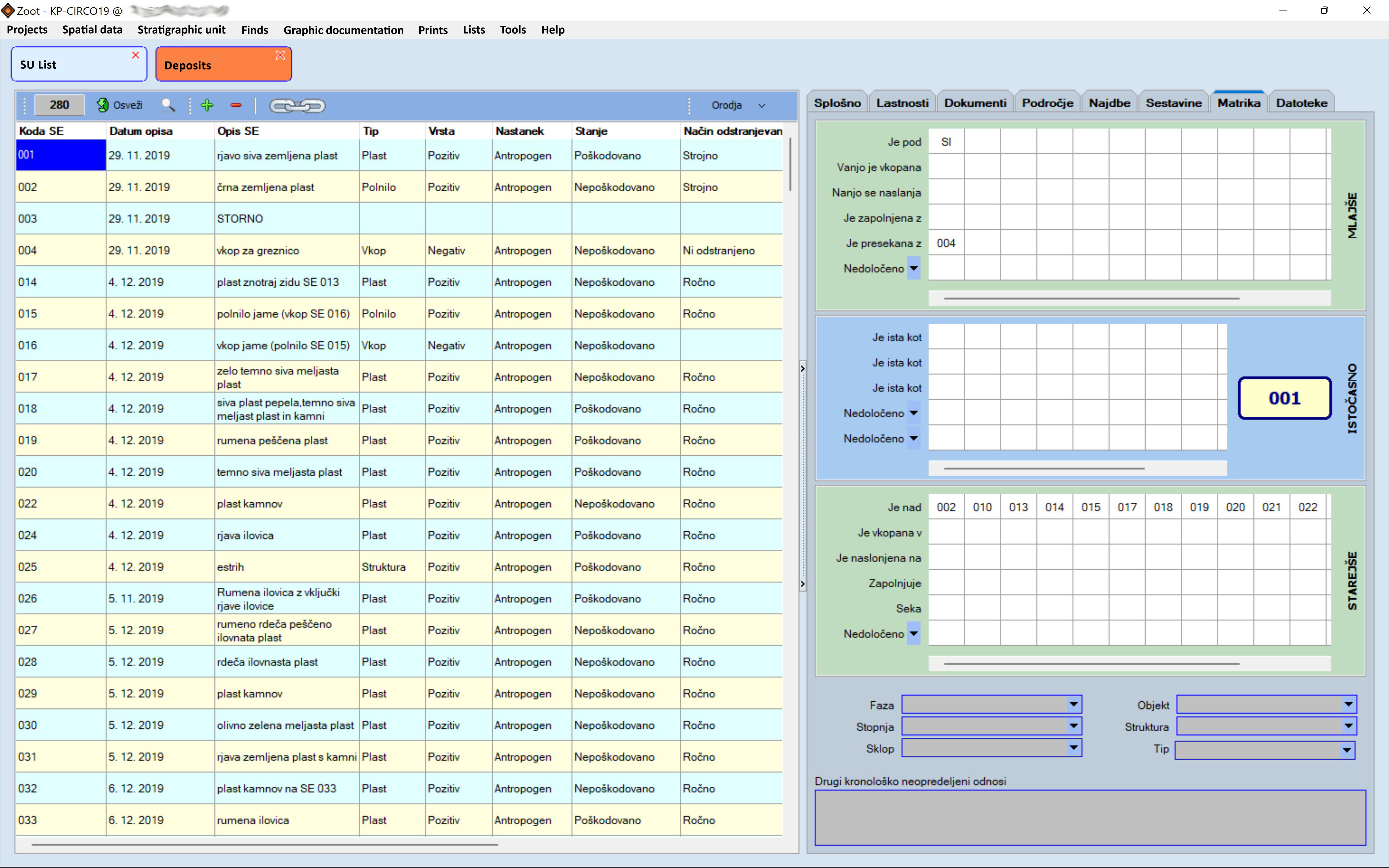
Menu for entering and processing stratigraphic unit data. The main feature is the list of stratigraphic units and their basic properties (Figure 5). The other data is entered through four additional sections: Deposits (positives, negatives, interfaces; Figure 6), Skeleton, Masonry Structure, and Wooden Structure.
Finds
This menu is divided into three parts. The first concerns data on Georeferenced Finds (Special Finds, Important Finds) and Separations, large samples that were subjected to separation methods such as dry sieving, wet sieving, or flotation. The Samples function is used to generate forms containing a list of samples and all relevant data to be sent to laboratories for further analyses (e.g. radiocarbon dating).
The second part provides the tools for cataloguing finds and tracking their processing, along with basic statistical overviews. The Processing (Small Finds) section is tied to the generation of find catalogues.
The third part, Materials and Periods, is used to compile detailed lists of finds and archaeological periods and describing their relationships.
Graphic documentation
This menu is also divided into three parts. The first is Photography, where the user can manage field lists and import digital photographs. The Slides function enables digitalising older projects.
The second part handles orthophoto maps and drawings as well as the files they are stored in. It also provides a quick overview of all graphic documentation. The third part focusses on the documentation of probes and profiles.
Prints
Four elements are found in this menu. The List of stratigraphic units prints a list of stratigraphic units and other relevant data as selected by the user. The next two options generate fit-for-publication catalogues in accordance with user-defined formatting rules: Catalogue (Small Finds) compiles a small finds catalogue and Catalogue (Stratigraphic Units) prepares a catalogue of stratigraphic units. The final option is User Defined Lists, with which custom lists can be generated (lists of structures, lists of graves etc.).
Lists
This menu is dedicated to managing the supplementary lists that help reduce the impact of potential typing errors. Preventing accidental data duplication improves the statistical accuracy and data screening processes.
Tools
Additional program configuration and individual project settings such as directory paths to certain files.
While the main menu offers a quick glimpse into the program's functionalities, many more are tucked away in submenus and the tools that open alongside data tables. The following is a summary of key functionalities:
Excavations transform physical cultural heritage into data. This phase of the archaeological process is essentially focussed on gathering data and should ideally aim to minimise the degree of interpretation. Once a sufficient amount of data and material remains (finds, samples) has been amassed, the second phase commences – data hunting, usually in the context of post-excavation procedures. This is the trickier part, since it entails managing, combining, and analysing a vast amount of data. A powerful tool is needed to perform these complex tasks in a manner that meets both the economic and the ethical standards pertaining to archaeological excavations.
By using Zoot, a smaller team can complete the same work in a shorter time, which translates into significant cost reductions. Zoot enables storing and processing the ever-increasing amount of data imposed by modern archaeological methodology and compounded by the expanding knowledge from other fields which support our data hunting and interpretative work.
There are several more arguments in favour of Zoot:
Our software does have certain shortcomings. Foremost among them is that it is still in development, which means we are continually adding new functionalities and fixing bugs. For this reason, potential Zoot users are offered access to our server free of charge to ensure smooth and automatic database upgrades. The only maintenance required of the user is to apply the provided updates to the program. The process of backing up databases is also handled by our server, which at present hosts over 200 ongoing projects for seven institutions, including a museum, a university, and private companies. The program is currently only available for computers running Windows, but could be easily ported to other platforms (Linux, iOS, Android). The reason we have not done this yet is simple: we are a small team with little time and money to spare. Zoot has one other major drawback which, however, will shortly be addressed: the user interface is for now only available in Slovenian.
The development of Zoot is funded by the company PJP d.o.o. based in Slovenska Bistrica, Slovenia. We are deeply grateful to company president Primož Predan, who has been successfully navigating the capricious waters of private business while remaining at heart an archaeologist.
Internet Archaeology is an open access journal based in the Department of Archaeology, University of York. Except where otherwise noted, content from this work may be used under the terms of the Creative Commons Attribution 3.0 (CC BY) Unported licence, which permits unrestricted use, distribution, and reproduction in any medium, provided that attribution to the author(s), the title of the work, the Internet Archaeology journal and the relevant URL/DOI are given.
Terms and Conditions | Legal Statements | Privacy Policy | Cookies Policy | Citing Internet Archaeology
Internet Archaeology content is preserved for the long term with the Archaeology Data Service (ROR). Help sustain and support open access publication by donating to our Open Access Archaeology Fund.
 Home
Home