Cite this as: Gheyle, W., De Decker, S., Stichelbaut, B. 2024 Digging Deeper is Always Rewarding. Policy instruments, challenges and recent research on conflict archaeology, WWI and WWII in Flanders, Internet Archaeology 66. https://doi.org/10.11141/ia.66.12
Belgium consists of three more or less autonomous regions: Flanders in the north, Wallonia in the south and Brussels in the middle. Whereas matters like defence and justice remain Belgian, other matters like education, public health, environment and heritage are assigned to the regions. Since our story starts from an archaeological point of view, we are limited to the borders of Flanders.
The organisation of archaeological heritage management in Flanders has changed gradually and profoundly since the Valletta Convention was signed in 1992 (Council of Europe 1992). The stepwise implementation of the 'polluter pays principle' in Flanders resulted in an important increase in development-led archaeological excavations, especially from 2004 onwards. These excavations resulted in huge numbers of archaeological site reports simply accumulating in the library of Flanders Heritage Agency.
Owing to the lack of funding for synthesising research beyond the responsibility of the individual developer, the ability to acquire new knowledge and insights based on thorough analysis and synthesis beyond site- and project-boundaries remained limited and under-exploited. To overcome this, the government of Flanders decided in 2017 to award yearly grants for synthesising research on archaeological data produced via development-led archaeology in Flanders. Our yearly budget to achieve this is about 800,000 euro, covering an average of 6 to 9 projects each year.
The grant system is open to the entire archaeological sector but particularly targets private companies in order to allow them to participate fully. Collaboration with partners and raising public awareness are two important criteria on which to judge the proposals. The added value of synthesising research is obvious. The new insights allow future research to become more efficient and to focus on previously unexplored questions and research fields. Synthesising research also reveals the amazing stories that archaeological research can generate, which are essential for raising more public awareness and, last but not least, increases the return on investment of the archaeological excavations.
Since it started in 2018, no less than 34 projects have been awarded and received grants for synthesising research on a specific topic or area. Three of those projects deal with 20th century conflict archaeology.
One project studied the trenches of the First World War in Flanders. The main aim of this project was to create a general typology of trenches that may allow the description, evaluation and study of trenches in a uniform way. A specific methodology was developed regarding how to excavate and study trenches, including a standard excavation form that can be used in the field. The researchers completed an inventory and analysis of over 100 archaeological excavations in Flanders where World War I (WWI) trenches were documented, corresponding to more than 15km of excavated war trenches. This inventory was completed with the study of thousands of aerial photos dating from the First World War.
A second project 'Missing at the Front' deals with the human remains of missing soldiers at the front in Flanders in WWI. Military cemeteries are an integral part of the landscape, with endless rows of white and grey headstones marking the graves of fallen soldiers. But despite these extensive cemeteries, the ground below the former battlefields is still full of remains of countless other soldiers declared missing in action. Some 55,000 dead from the British Commonwealth were never found and remain missing. On the German, Belgian and French sides, the figures are more difficult to calculate due to a lack of comprehensive lists. But here as well, we are talking about tens of thousands of missing soldiers, especially on the German side. The casualty figures for some of the famous battles speak volumes: the Second Battle of Ypres cost 15,500 Commonwealth lives, of which about 75% have no known grave.
Missing soldiers are unearthed by chance from time to time while ploughing fields, during construction works or archaeological excavations. This synthesising project analyses the way we can or should act as archaeologists when confronted with human remains of soldiers, from a scientific as well as from an ethical point of view. The project not only aims to make a statement of affairs, but also provides a framework for future excavations and research.
The study of WWI material remains has progressed enormously in Flanders in recent decades. The same is increasingly true for World War II (WWII) remains. There is growing attention given to recent conflict archaeology in excavations and knowledge about this period is increasing. However, no comprehensive overview has been available until now.
The aim of this study was therefore to bring together all the data from excavations that had already been carried out, starting from the available online catalogues and inventories, but also by asking all the archaeologists and archaeological businesses in Flanders. On this basis, an inventory of the types of site and archaeological traces was made and the geographical distribution of these phenomena analysed. As a second step, the researchers contrasted the archaeological data with historical aerial photos and LiDAR data to further interpret the sites and compare the knowledge gains.
Three specific themes, each with their own specific challenges, were elaborated on in depth by specialists: namely Atlantic Wall sites, military airfields and aircraft crash sites. The results of the research are both practical and substantive. There is an interpretation key and methodological guidelines, and challenges were identified with linked recommendations. Finally, an extensive part of the project focused on public engagement through exhibitions and a book for a general audience.
In the project, the data and results from 172 excavations were brought together. This was many more sites than had been expected, although it is still a minimal amount. They range from fortifications to crash sites scattered all over Flanders. This is in contrast to the distribution of WWI sites, which are concentrated in the coastal front region in the west of the country. It is also striking that the annual number of identified WWII sites is clearly growing with around 15 to 20 new sites being added each year.
The distribution of sites is linked to specific regions and the course and evolution of WWII in Flanders. The clustering of sites in specific regions is quite obvious and meaningful. From east to west, it is largely chronological from the run-up to the conflict and invasion in May 1940 with Operation Fall Gelb in the east of the country, to the construction of the Atlantikwall on the coast in the west of the country (Figure 1). In each case, the clusters also correspond to strategically important Belgian pre-war defensive elements including the defences along the Albert Canal, the main defence position or KW line centrally in the country, and the defensive belt around Ghent.
In the east we see early sites related to Belgian defence lines and the mobile war during the Eighteen-Day Campaign, when the Belgian army tried to delay the passage of the German army after the invasion in May 1940, and they had to give up position after position until Belgium became fully occupied territory. Consequently, we mainly see traces of a mobile war.
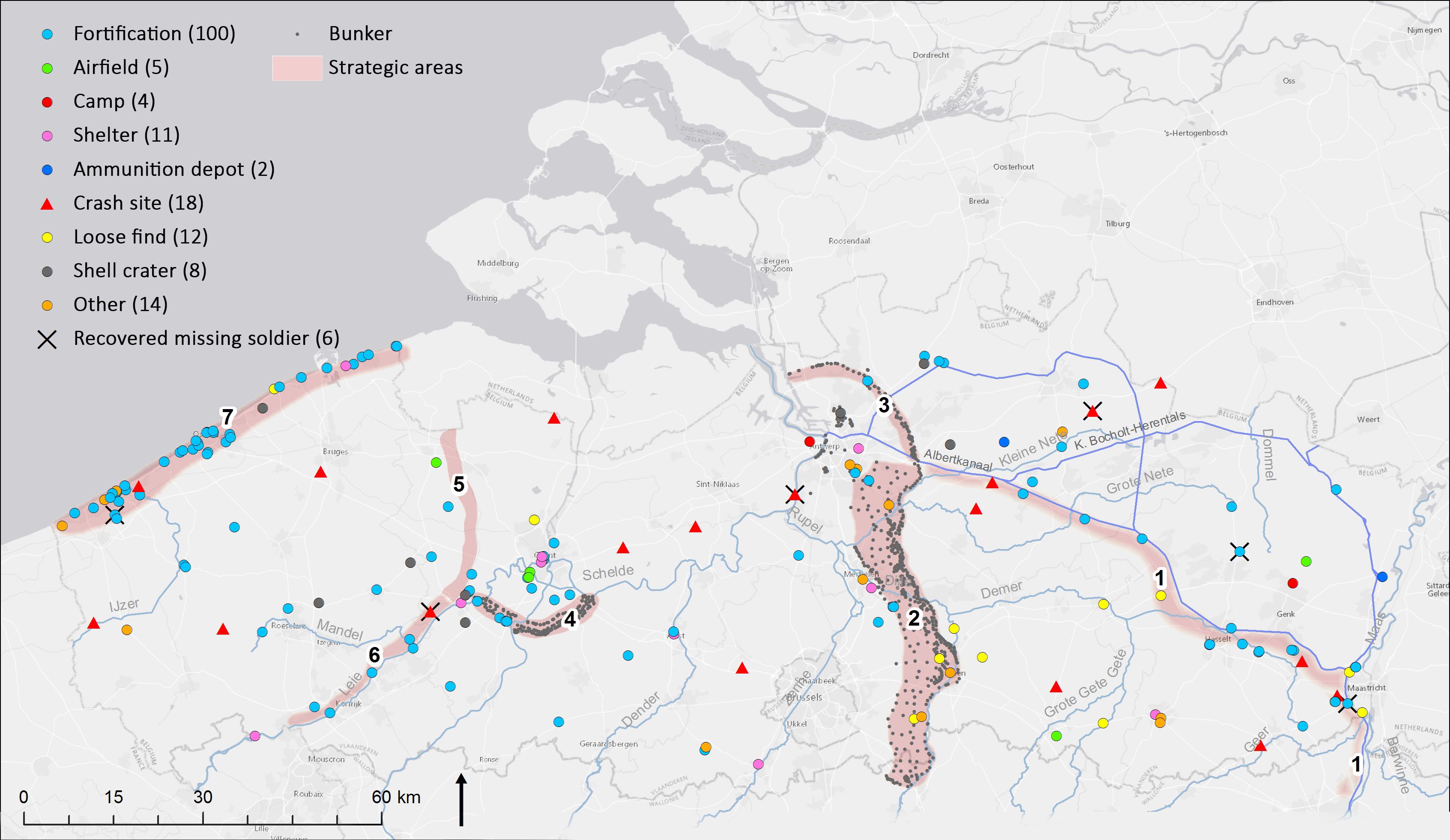
During the German occupation, a lot of military infrastructure was built. One of the largest and best-known defensive positions is the German Atlantikwall, 65km of which runs along the Belgian coast. The archaeological preservation of these fortifications is very good, but much has also been destroyed by building expansion along the Belgian coastline. The pressure of tourism facilities built up quickly in the decades after WWII. Thirty three sites have been archaeologically investigated. In general, bunker construction is immediately thought of here: large concrete structures all over the dunes, and there are indeed hundreds of them. But they formed a dense network and were connected by tunnels, stairs and trenches. Today, it is also clear that the Atlantic Wall should be seen as an archaeological landscape which includes the hinterland. Aerial photos show traces of defensive structures up to 15-20km inland (Figure 2).
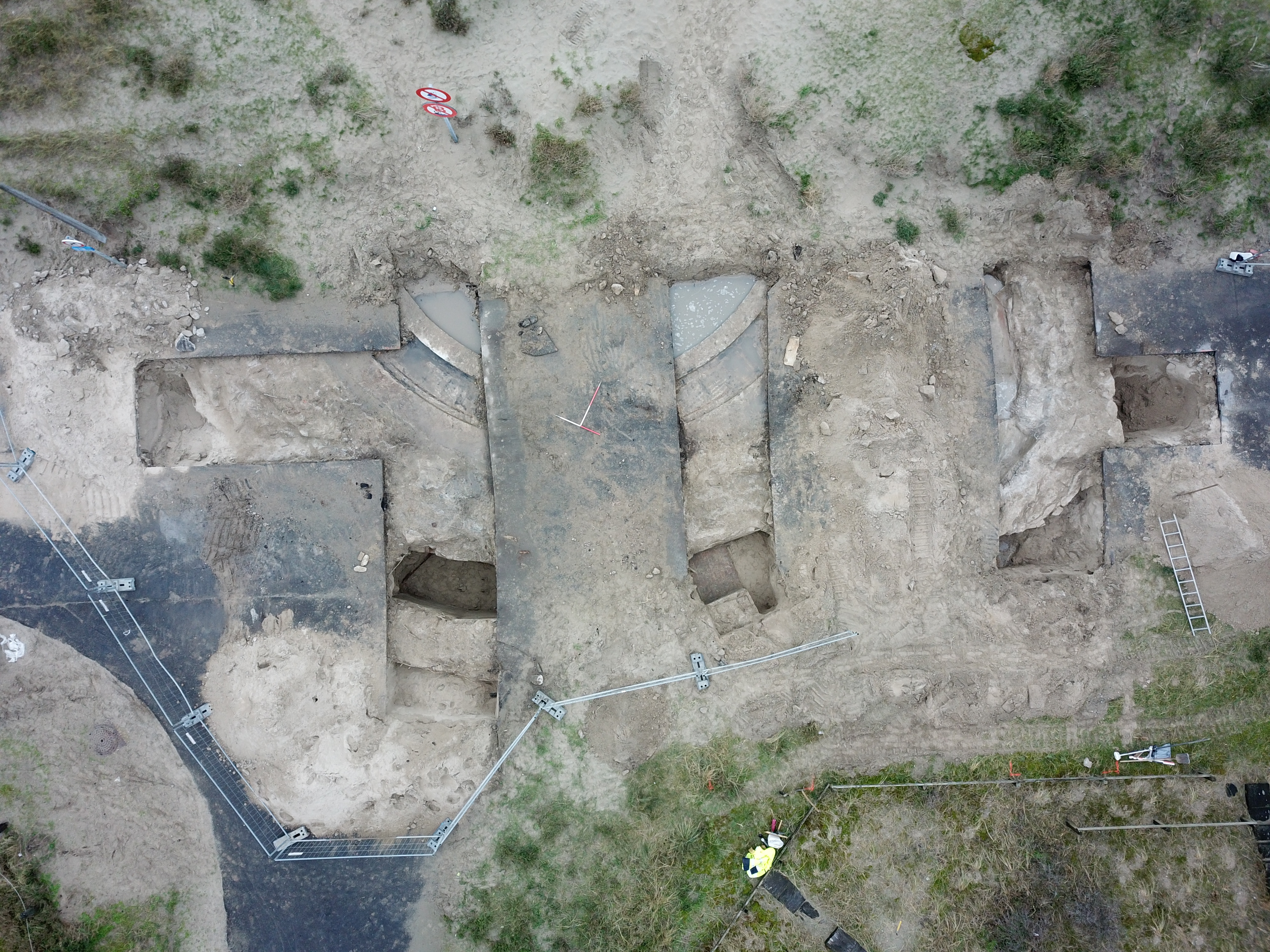
Archaeology has a great added value here: historical knowledge about these structures is rather conceptual and although many bunkers are known, there is no overview of the archaeological heritage. In any case, the archaeological heritage is much more extensive than previously thought. In addition, archaeological research offers insights into the much more transient structures such as barracks and earthen field fortifications, and the material culture of the conflict.
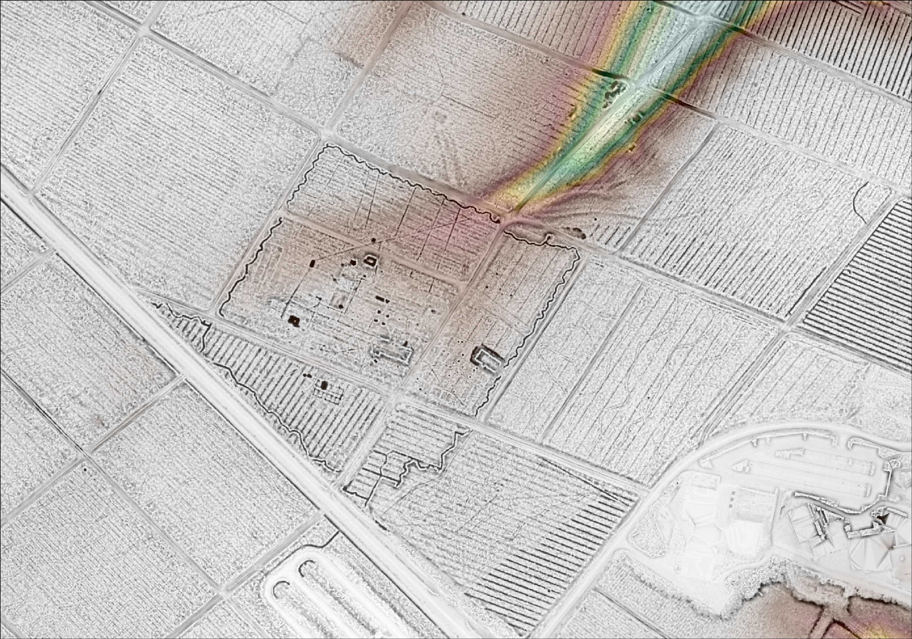
One particular facet of infrastructure worth noting is the network of military airfields, some of which had been operational even prior to the war. Post-1945, a series of new Allied airfields were integrated alongside the existing Belgian and German bases. Additionally, several sites underwent modifications and were repurposed for various military functions. Remarkably, there has been minimal examination of these sites thus far, with only three former German airfields and one Allied airfield receiving any scholarly attention (Hoorne et al. 2008; Stichelbaut and Hoorne 2008; van Bavel et al. 2017; De Brant et al. 2017; De Brant et al. 2018; Deville et al. 2020).
This observation raises a curious point, considering that there were undoubtedly over 20 active airfields, each occupying substantial acreage and expected to hold a wealth of material evidence. The relative obscurity of these airfields to archaeological organisations might account for the oversight in documentation of these historical relics.
From an archaeological perspective, the spectrum of findings is extensive, encompassing everything from runways to anti-aircraft defences, from hangars to bomb craters. The unique contribution of archaeology in this context can complement the existing historical knowledge and ground the narratives of these sometimes-vanished sites in the contemporary landscape.
The investigation of crash sites constitutes the third aspect the researchers examine in detail. During WWII, approximately 6000 aircraft crashed over Belgium within a five-year span. This investigation represents a highly specialised sub-discipline accompanied by unique challenges. These challenges include managing the presence of human remains, handling substantial quantities of scrap metal, and accessing the random locations across the landscape where these incidents occurred.
The Aircraft Archaeology Protocol was implemented in 2009, and these crash sites have been officially designated as heritage sites, subject to specific research methodology guidelines. Since then, a total of 18 crash sites have undergone thorough investigation using this protocol. The findings from these investigations have yielded a comprehensive proposal outlining the approach to such sites, ranging from initial geophysical prospecting to preliminary research and culminating in the proper storage of recovered materials in archaeological depots.
Belgium experienced another period of mobile warfare during the Allied liberation efforts in the latter half of 1944. This was followed by the final phase of the conflict, characterised by the terror of unmanned V-bombs, which have also left behind archaeological traces. In the immediate aftermath of liberation, evidence of the American and British presence in Belgium emerges, closely tied to the support provided for the Ardennes offensive, the repatriation of military units, and the establishment of extensive camps for prisoners of war.
These 172 sites provide us with a huge dataset that gives a unique view on the material culture of WWII, brought together in an overview with a clear interpretation key. Different sources include juxtaposed historical images, archaeological information from surveys and cross-sections, and above-ground preservation of structures as visible on the digital elevation model (Figure 3).
The challenges are as follows:
The recommendations are as follows:
The common thread in the three studies mentioned above is a remote sensing perspective based on historical aerial photography taken during WWI and WWII. Digging deeper, then, into the subsurface and archaeological reports, but also flying higher, which brings us to the aerial overview. Our main sources of information are unique historical documents: thousands of historical aerial photographs taken during the wars by all fighting parties. During WWI, millions of aerial photographs were taken worldwide, of which about 500,000 survive in the archives. The numbers are even higher for the Second World War.
Why choose these photographs as a primary source of information? They are contemporary and actually show us the object we are studying, which is rare in archaeology. Secondly, they are more reliable than maps, as maps are always an interpretation, whereas the photos are the source material. Thirdly, the detail of the images is amazing, providing an unparalleled insight into the conflict landscape.
The province of West Flanders has a long-lasting collaboration with Ghent University and the In Flanders Fields Museum (Ypres) to explore these unique aerial photographs as the Centre for Historical and Archaeological Aerial Photography (CHAL). Each partner has its own input and output. CHAL focuses on research, valorisation and provides useful data for heritage management.
There are several million aerial photographs from WWI and WWII in the archives. We are not just interested in the images as documents, but rather in the features that are visible on the photographs. After digitisation, we ensure that the photos are digitally mapped in a geographic information system (GIS) and georectified by identifying ground control points visible on the aerial photographs and finding their corresponding locations on a modern digital map.
One image is nice and gives local information, but thousands of images give us an unprecedented view on the war landscape, with a chronological resolution sometimes of a couple of days. This is the main source of information for our research on the archaeology and landscape of both World Wars.
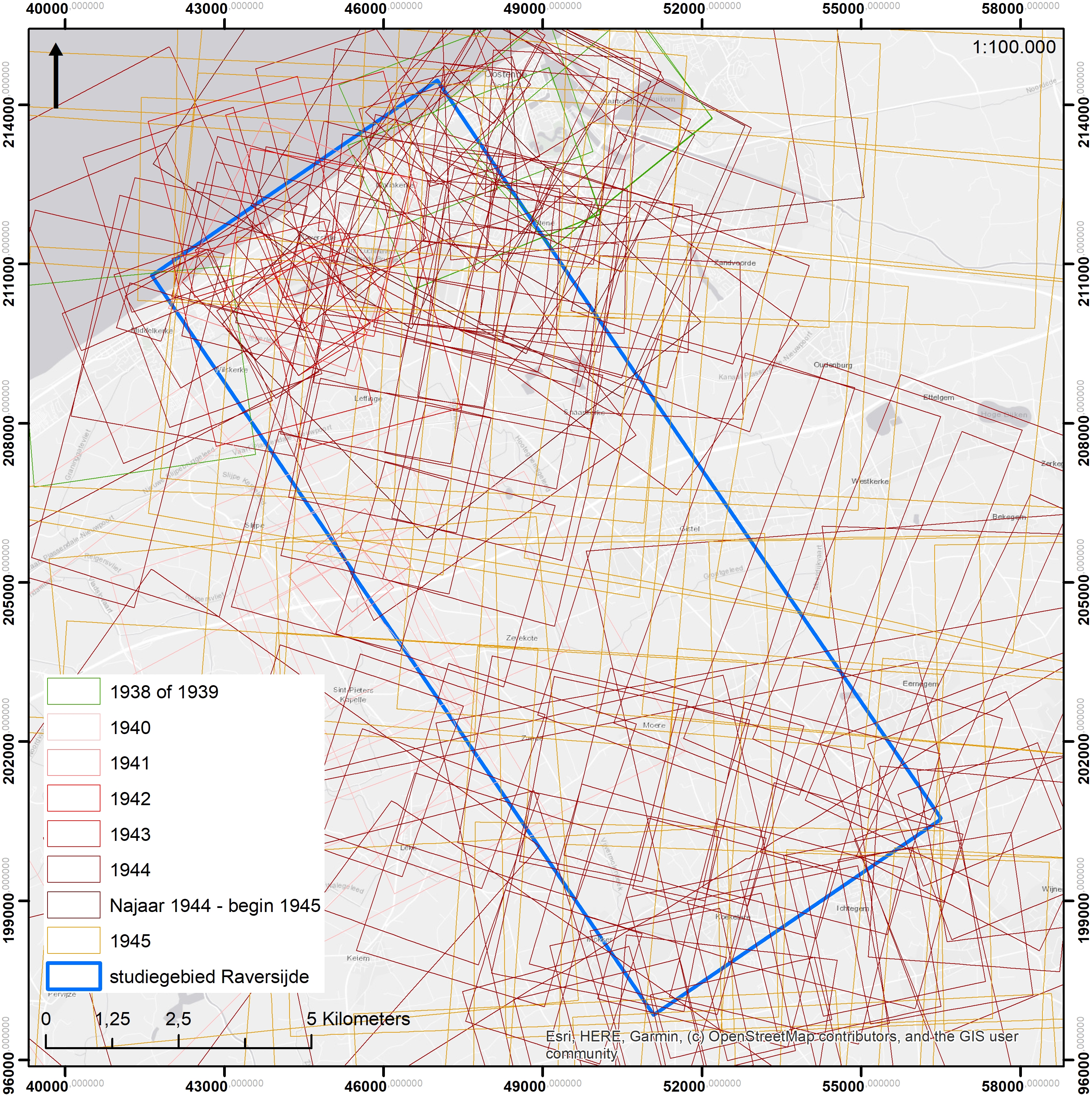
So far, Ghent University has built up a dataset of over 43,000 WWI and WWII aerial photographs covering Belgium and parts of northern France (Figure 4). This forms a strong basis for the research on conflict landscapes, but at the same time is also a valuable source for science communication and public outreach, and is of major importance for heritage management and improving the efficiency of archaeological research.
We cannot simply use the photographs as they are. Instead, we must meticulously examine them to identify a wide range of distinct structures. These may encompass everything from barbed wire and trenches to gun positions and hideouts. By mapping all relevant features in a GIS, a detailed dataset that can be consulted and analysed is created.
Over 22,000 WWI aerial photographs have been mapped to date, resulting in over 250,000 distinct war features. The results are detailed and accurate maps of both the frontline and hinterland depicting the extensive networks of trenches, gun emplacements, bunkers, barracks and other military infrastructure. A similar effort is currently underway for the WWII landscape in the province of West Flanders.
The landscape perspective also offers us unique opportunities to valorise research results and bring them to the public. The aerial photographs are a very strong visual tool that allow us to bring the story of sites and places to life and inspire the imagination and interest of visitors.
One notable and highly successful application is the 'In Flanders Earth' interactive interface featured in the 'In Flanders Fields Museum' in Ypres. This platform allows visitors to explore past and present perspectives of the Western Front in Belgium. Every visitor has the capability to zoom in on their home address or another place of personal interest and look at WWI aerial photographs of any given place. Through this means, we effectively bring the war landscape directly into the museum experience.
A similar initiative was undertaken for the Museum Lens '14-18', where an extensive mosaic of WWI photographs spans the entire Nord-pas-de-Calais department, complemented by ground-level photographs depicting the devastation of villages at the front.
The museological applications aim to foster visitor reflection on the vast scale and intensity of the war, as well as its profound impact on both the landscape and society. However, their primary objective is to inspire visitors to venture out into the actual landscape itself. With this aim in mind, we sought innovative ways to seamlessly integrate the museum experience with the surrounding environment, juxtaposing today's agricultural fields and villages with the wartime scenes of total destruction and massive war infrastructure. The widespread availability of personal mobile devices, such as smartphones and tablets, made this endeavour readily achievable.
Contemporary and historical photographs are skilfully superimposed, allowing for a seamless blend of the past and present. This transparency enables viewers to compare the 'then' and 'now' perspectives. Building upon this concept, CHAL has developed a series of 'Ypres Salient 1914-1918' apps. These apps offer four approximately 4km-long walking tours that participants can undertake with their portable devices. As they walk over historical aerial photographs, they traverse the former front lines and no-man's-land, gaining a visceral sense of how closely the lines were positioned in certain areas. Each point on the map serves as an area of interest, providing additional information and storytelling, including details about archaeological excavations.
For the WWII project mentioned above, an open-air exhibition in the Atlantikwall museum in Raversijde (Ostend) was developed. The temporary exhibition compared the historical aerial photographs with the results of archaeological excavations on WWII sites and a coastal panorama of 75m long, based on American aerial photographs taken in August 1945. This remarkable view of the Belgian coastline during WWII is now permanently displayed on the museum wall and open to the public free of charge.
CHAL also brings the aerial photographs to people at home. Recently, the geoportal 'Aerial Photo 1914-1918' was launched, with a selection of 2,500 aerial images over the province of West Flanders. It attracted 60,000 online visitors in the first two months, showing that it is a subject that appeals to the wider public. The geoportal makes aerial photos available in a very intuitive way, where you can search by address, use transparency to compare the situation then with today, and read information about the photo.
In 2022, Ghent University did the same with aerial photos of the Second World War in the province of Limburg. Here, we chose to actively involve visitors in the research, asking them to add testimonies and stories to the geolocation: 'Onder de Radar'. The 900 aerial photos include American and very rare German aerial photos, showing the military infrastructure in the province of Limburg in great detail. Over 1,600 points of interest have been marked and annotated by visitors, accompanied by stories, old photographs, and local knowledge about the events that happened there about 80 years earlier.
Internet Archaeology is an open access journal based in the Department of Archaeology, University of York. Except where otherwise noted, content from this work may be used under the terms of the Creative Commons Attribution 3.0 (CC BY) Unported licence, which permits unrestricted use, distribution, and reproduction in any medium, provided that attribution to the author(s), the title of the work, the Internet Archaeology journal and the relevant URL/DOI are given.
Terms and Conditions | Legal Statements | Privacy Policy | Cookies Policy | Citing Internet Archaeology
Internet Archaeology content is preserved for the long term with the Archaeology Data Service (ROR). Help sustain and support open access publication by donating to our Open Access Archaeology Fund.
 Home
Home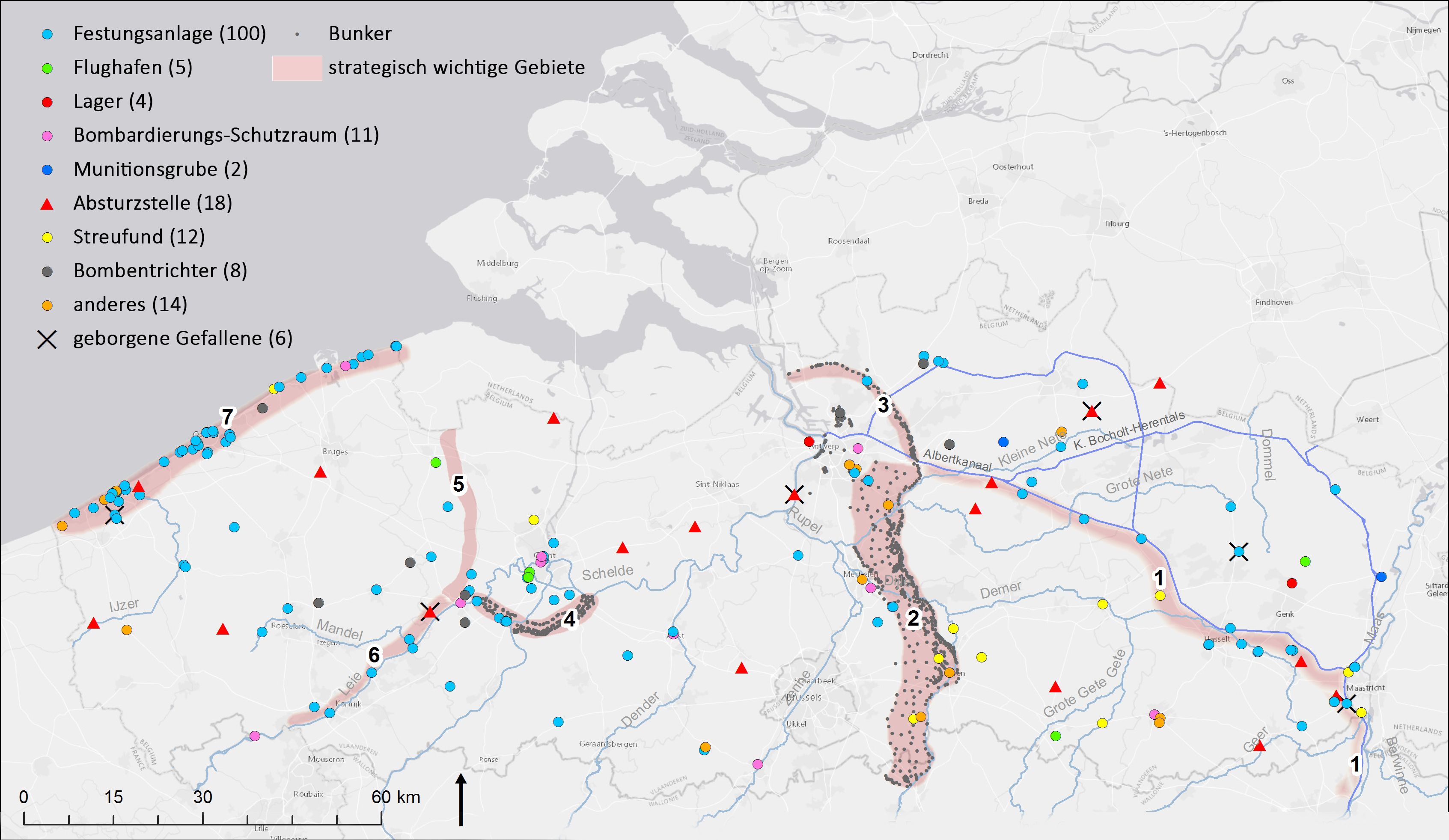