Cite this as: Dennehy. E. 2024 Different Schemes, Same City? How lessons from Luas Cross City works are informing the design and implementation of the Luas Finglas and MetroLink Cultural Heritage Strategies, Internet Archaeology 66. https://doi.org/10.11141/ia.66.20
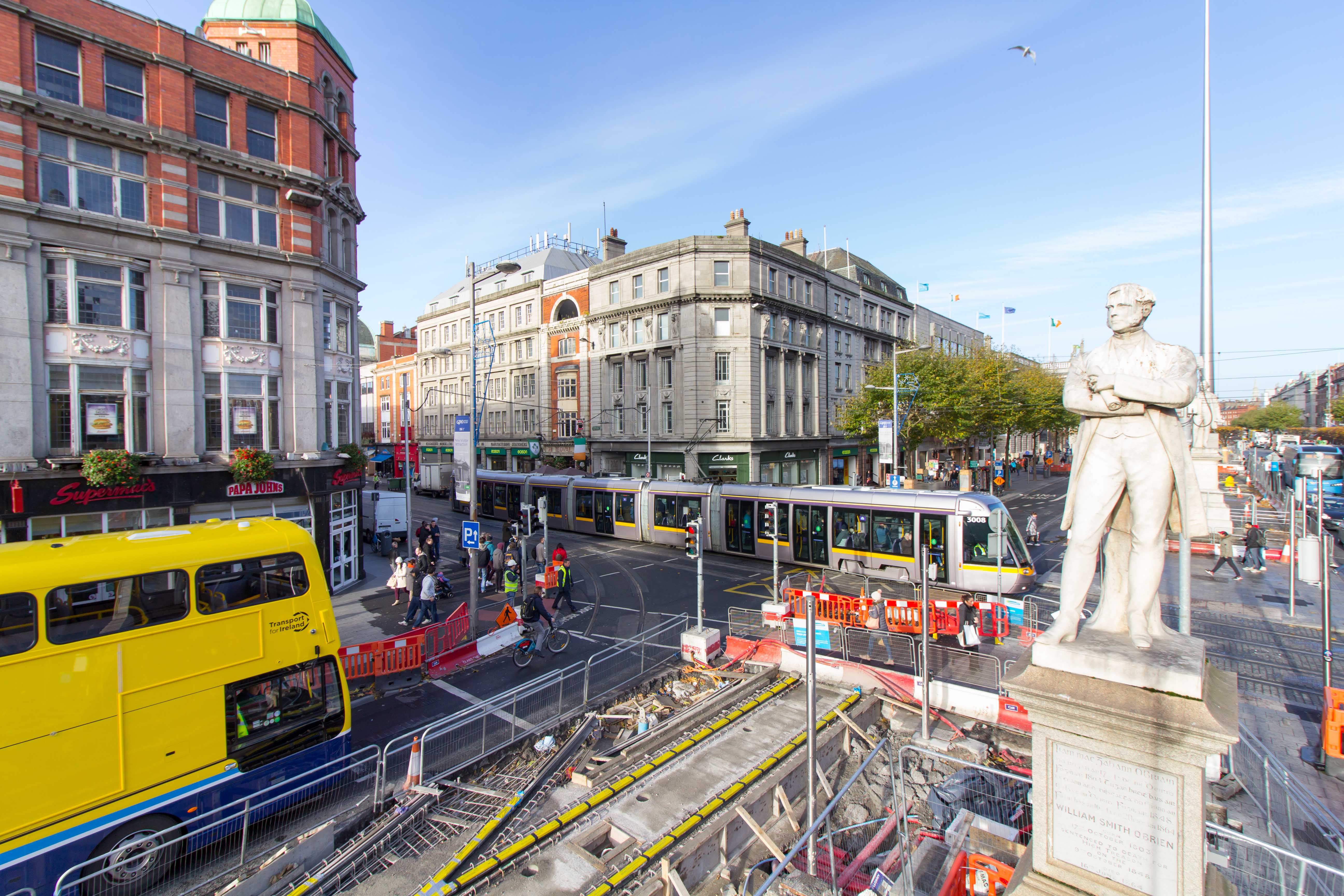
The first phase of Dublin's two light rail lines operating as Luas (the Irish word for 'speed') were opened in 2004, serving the north (Red Line) and south (Green Line) city areas respectively. Each line underwent various phases of expansion, but it was not until December 2017, after a decade of planning and four-and-a-half years of construction, that Luas Cross City (LCC), an extension of the Luas Green Line, was officially launched. Although LCC comprised 'just' 5.9km of light rail infrastructure, it was notable for crossing the heart of the modern city (the first time that the two Luas Lines were linked) resulting in a fully interchangeable sustainable public transport scheme. Ultimately, the construction of LCC realised the intent and ambitions of Luas' original champions whose concept design was for both Luas lines to be linked (Figure 1).
Building on the success of these schemes and responding to the government's Project Ireland 2040 strategy (Government of Ireland 2018), Transport Infrastructure Ireland (TII) is now planning Luas Finglas, a 4km northern extension of the Luas Green Line from its present terminus at Broombridge to Finglas Village. In addition, on 30 September 2022, TII lodged a Railway Order Application for MetroLink - an 18.8km metro system comprising 11.7km of single bore tunnel (City and Dublin Airport Tunnels), 7.1km of grade separated track and 16 stations. MetroLink is a megaproject with a 10 year construction programme, five major construction works packages and over 40 sub-contracts. Both schemes traverse a cultural heritage environment similar to that identified and archaeologically explored on LCC. Thus, they allow TII Archaeology and Heritage to work in a familiar environment, benefit from lessons learned and, importantly, collaborate with statutory and non-statutory bodies and private landowners in a more informed and proactive manner than was possible for LCC.
For the purpose of environmental planning and contract management, LCC was divided into two areas: Area 29 and Area 30 (Figure 1). The southern end of LCC (Area 29) comprised 3.05km of single and twin track, commencing at St Stephen's Green Park (a national monument in state ownership) and progressing north to cross Constitution Hill (Figure 2).
Although Area 29 is within the heart of the modern city, serving the main northern and southern districts of O'Connell Street and Grafton Street respectively, it is located approximately 330m east of the medieval city's outer circuit wall (Figure 3). LCC's receiving landscape was largely developed from the late 17th century, substantially damaged by the 1916 Rising, the Civil War (1922-1923), damaged physically (rather than culturally) to a much lesser extent by 'the Troubles' and is permanently evolving to meet the population's needs. From 2010 to 2022 this area was also included on Ireland's UNESCO World Heritage Tentative List, comprising a predominantly Georgian Landscape referred to as 'The Historic Town of Dublin'.
On exiting the 'historic town', LCC crosses through the former Broadstone Branch and Harbour of the Royal Canal, passing to the fore of the Midland Great Western Railway's (MGWR) terminal building ('Broadstone Terminal') before entering the former MGWR depot and railway cutting (Area 30; Figures 2 and 4).
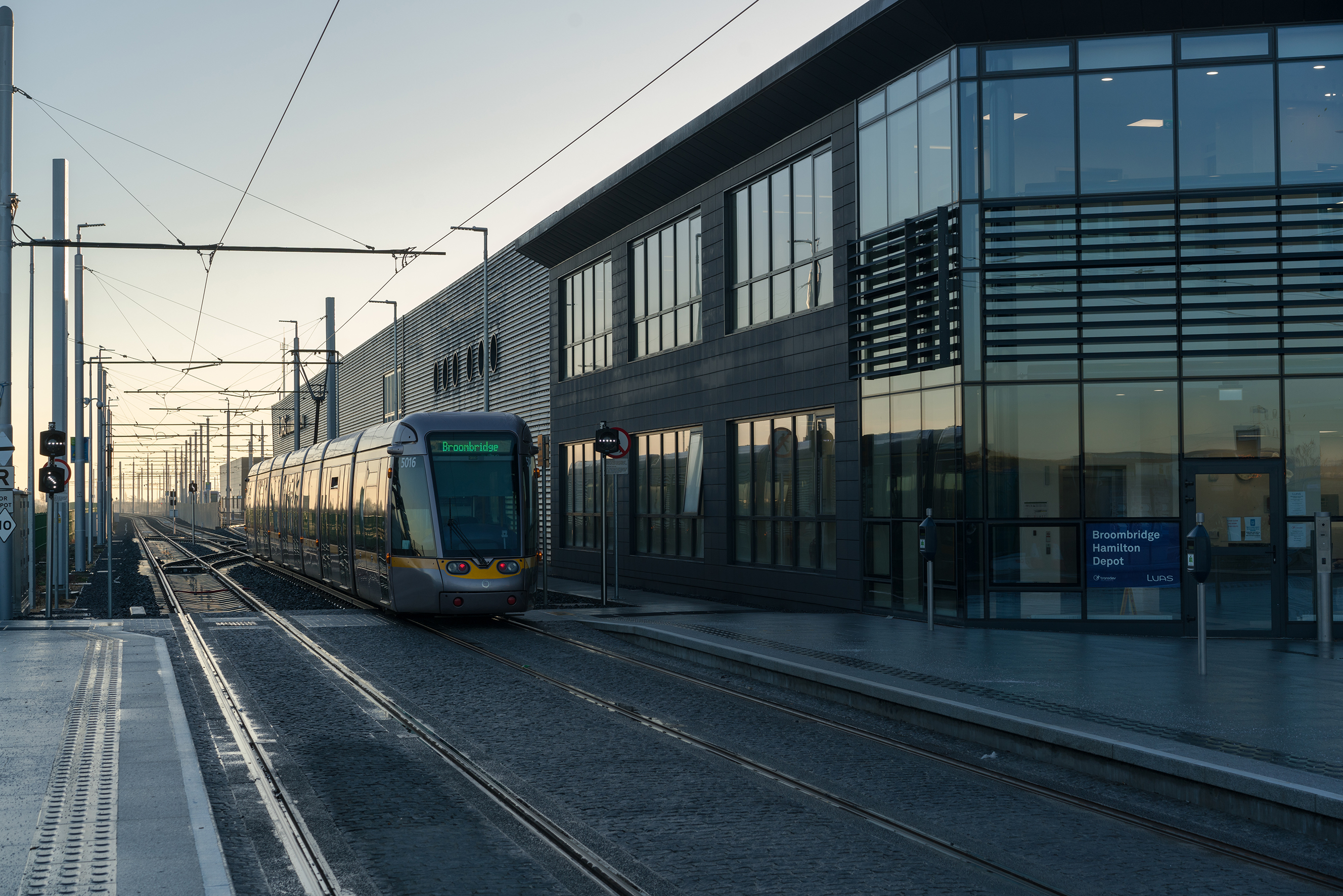
The scheme terminated at Broombridge, where a new depot was constructed on lands immediately parallel to the MGWR and Royal Canal (Figure 5). Broombridge also marks the location of where Sir William Rowan Hamilton solved his theory of Quaternions and is thus the site of an annual mathematics pilgrimage.
In LCC's primarily on-street urban environment, the advance excavation of archaeological sites, even where they were known to exist, was not possible and thus heritage management had to be achieved within the remit of the project's programme and procurement strategy as agreed with the National Transport Authority (NTA), the approving authority for Ireland's light rail schemes. In the absence of a discrete archaeological works package, each appointed LCC Contractor for the two Enabling Works ('Investigation and Treatment of Cellars' and 'Utility Diversions') and Main Infrastructure Works contracts was required to accept the archaeological risk and engage their own team of archaeological consultants ('Contractor's Archaeological Consultants') to monitor all site works and to complete all necessary archaeological excavations as approved by the TII Project Archaeologist. The potential location, range and depth of archaeological material that could be identified during site works was identified for contractors at Tender Stage within a series of documents, namely the LCC Environmental Impact Statement (RPA 2010), LCC Archaeological Desktop Assessment Reports, and the LCC Archaeological Heritage Strategy. These in turn were informed, where possible, by the results garnered from the archaeological monitoring of Geotechnical Investigations and Utility Slit Trench Surveys undertaken at the scheme's planning and design phase.
During construction works, the Contractor's Archaeological Consultants issued immediate notifications to the TII Project Archaeologist of every archaeological discovery, with a case-by-case strategy for excavation and resolution discussed and formally agreed between both parties. The policy for LCC works was to record every archaeological deposit/structure, with the agreed duration of stoppage time equating to the age and complexity of the stratigraphy and potential value of the arising archaeological knowledge.
Within Area 29, the archaeology discovered ranged from discrete deposits (predominantly historic demolition waste), fragments of historic paving and utilities, to mid-18th and 19th-century coal cellars, church foundations, and, stepping further back in time, five Tudor burials located on College Green, just outside the entrance to Trinity College Dublin (Figure 6).
Area 29 works also included the protection in situ or removal, conservation and reinstatement of various elements of historic buildings, statues and street furniture along the route under archaeological supervision. This included the O'Connell, O'Brien and Parnell National Monuments (each of which was located within 1m of the construction zone; Figure 7); the Thomas Moore and Molly Malone statues, in addition to lesser-known memorials to victims of the 1974 Dublin-Monaghan Bombings.
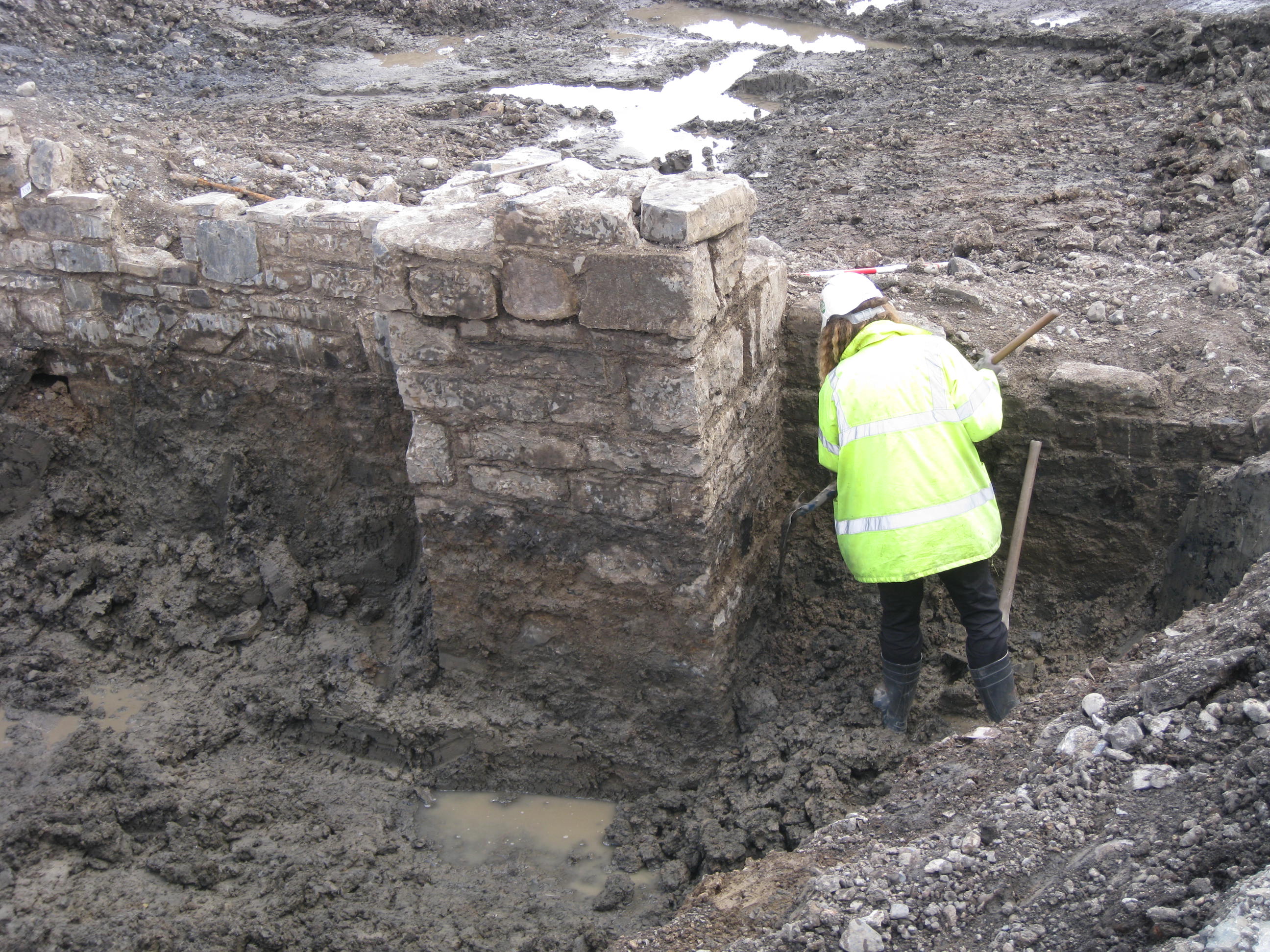
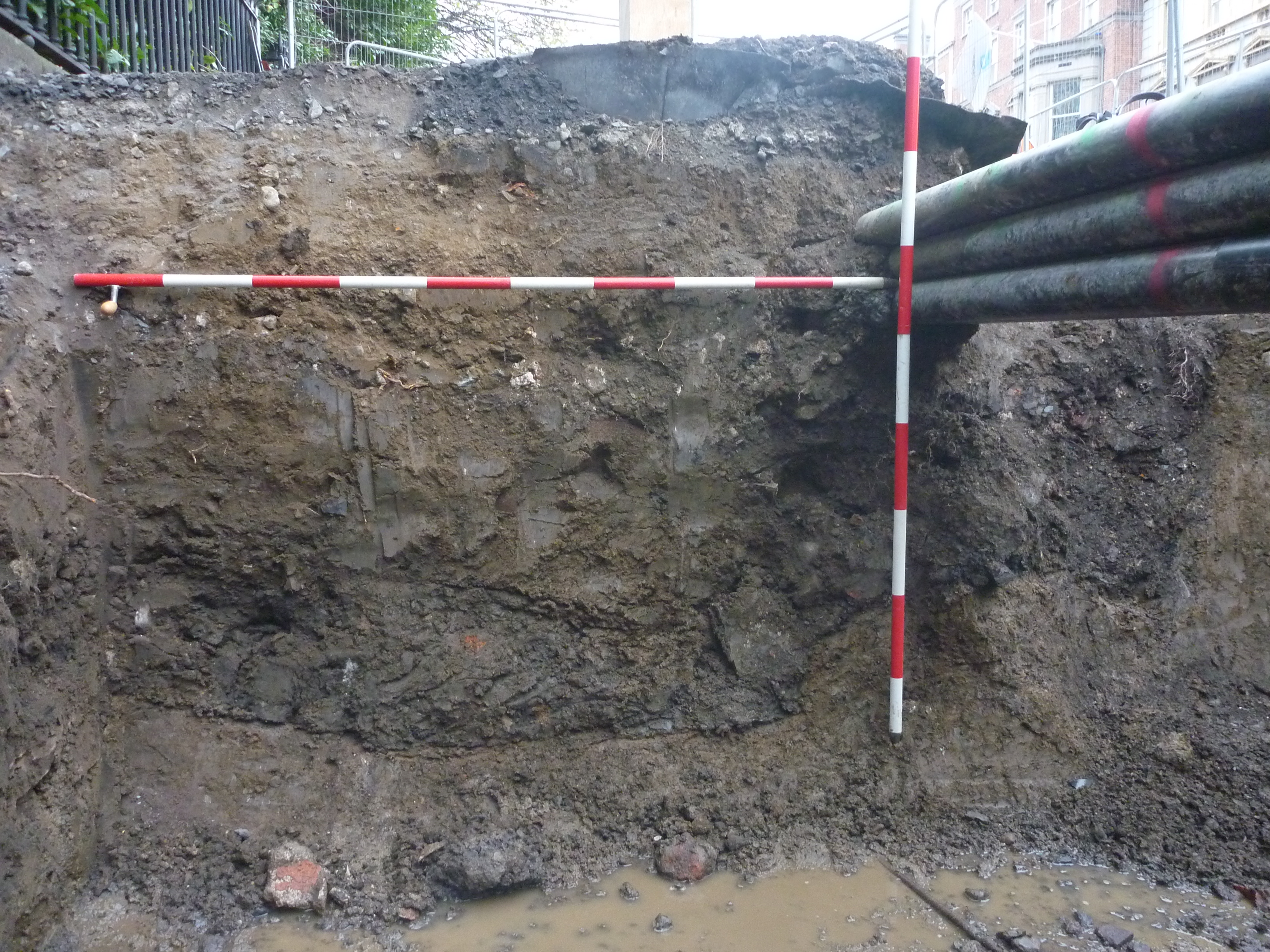
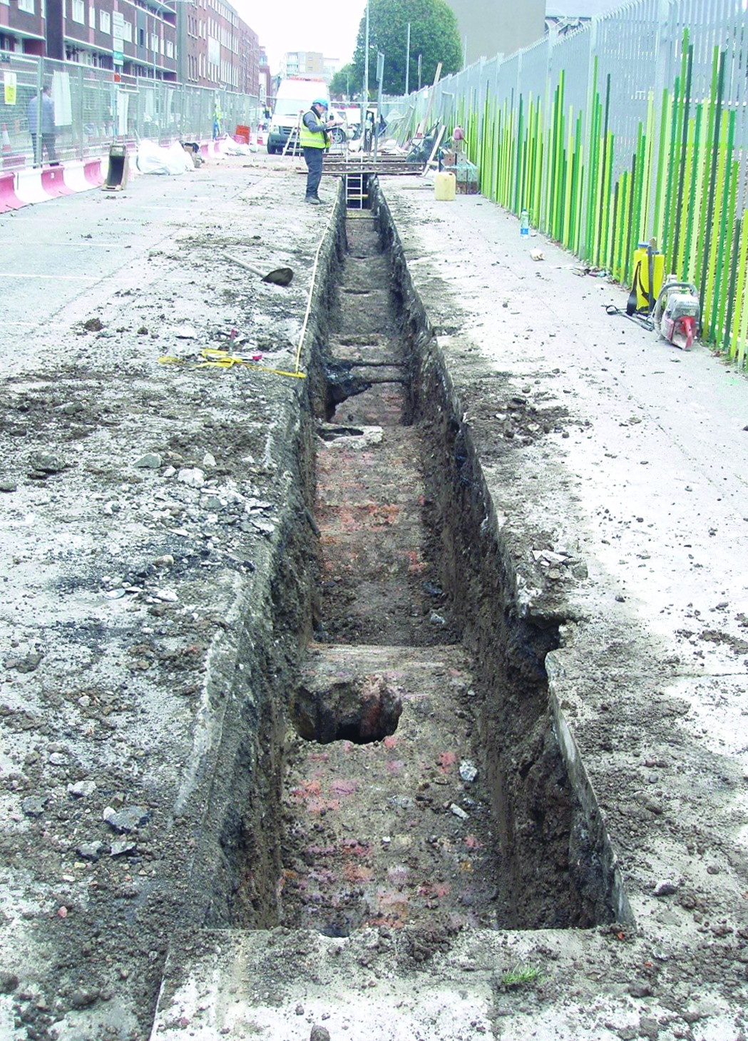
Within Area 30, 8m-deep excavations of the Royal Canal Broadstone Harbour and associated warehouse, inclusive of an underlying relict mid-late 18th-century landscape, took place in tandem with complex multi-phase construction works (Figures 2 and 8).
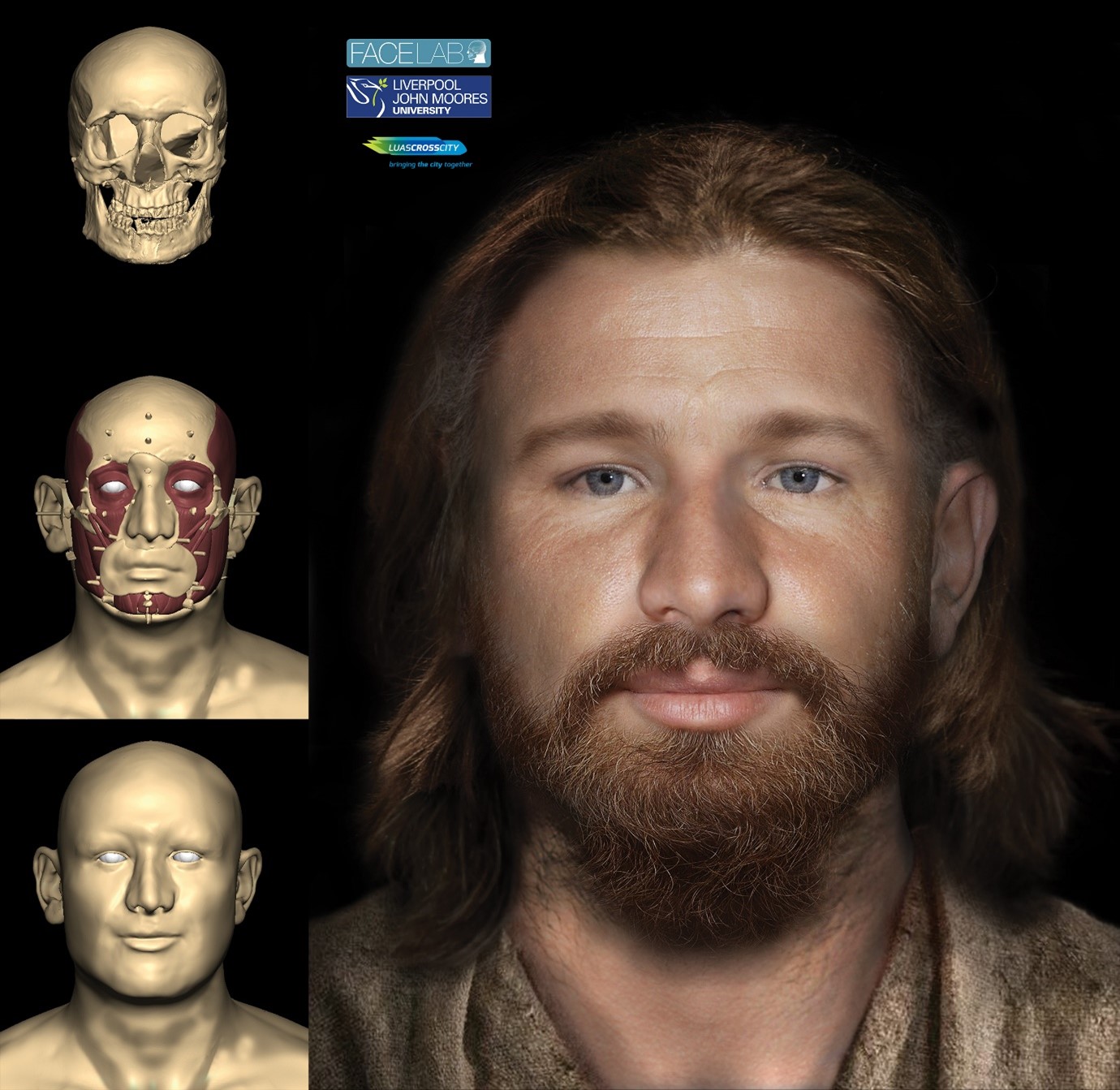
Within the MGWR lands, retaining walls, railway drainage, manure works, engine sheds, turning circles, roundhouses and historic tracks were identified. However, one of the most crucial finds was a series of graves, charnel trenches, pits, and deposits relating to the cholera pandemic that swept through Europe in 1832. It transpired that the victims were originally interred in individual plots in the gardens of the then Richmond Penitentiary, which was converted to the 'Dublin Cholera Hospital' during the pandemic. In 1875, the MGWR bought 3 acres of this garden from the penitentiary to facilitate expansion works. It was known that MGWR workers came across human remains that they reinterred on an 'isolated patch of ground', which materialised during LCC works to primarily comprise Grangegorman Laneway. In all, the remains of 1615 individuals were recovered, only 34 of which were articulated burials, with over 18,700 comingled bones recovered (Figure 9). All of these remains were fully excavated and analysed through a comprehensive post-excavation programme.
When monitoring construction works in an urban environment, and repeatedly revisiting the same construction zones for various activities and extracting fragmented archaeology in a piecemeal manner with different Contractors' Archaeological Consultant teams, it can be quite difficult to appreciate or accurately convey the heritage value of what was recovered. However, the ongoing approach for a meaningful interpretation of LCC's archaeological and cultural heritage results is based on a change of narrative. It involves stepping back and exploring the cumulative value that these small pieces of stratigraphy can offer towards our understanding of the archaeology of a living city. It was essential to capitalise on the insights gained by the excavation directors and archaeologists who had been working closely on this scheme, particularly as a small number of the Contractor's Archaeological Consultant's worked on all three construction works packages and acquired a comprehensive appreciation of what had been found over the extended construction period. Certain themes became apparent through their site work, such as the demise of once grand Georgian townhouses for use as tenements; how the provision of piped water and sewerage changed the landscape of the public realm (particularly in the environs of St Stephens Green Park); the city's response to pandemics and industrialisation; and the lasting impact of war on the fabric of its built environment and cultural heritage.
In transitioning from LCC construction and post-excavation phases to working on the planning and design of Luas Finglas and MetroLink, the heritage and engineering value of the archaeological works became apparent. Luas Finglas will be constructed in a similar manner to LCC; however, it also requires the construction of a substantial bridge to cross both the MGWR and Royal Canal at Broombridge. The depth of Luas works is generally limited to 1.5m both for the continuous track bed alignment and utility diversions, though in isolated areas where, for example, side-entry manholes are required, more substantial depths of 5m may be required. In contrast, the top-down excavations for the City Tunnel portion of MetroLink is limited to lands immediately required for each station box construction, plus the establishment/installation of compounds, utility and temporary road infrastructure. Station boxes will be 104-116m long, 24-25m wide and 26-30m in depth; utility constructions will typically be 1.5-2m deep and confined to the immediate station environs.
TII's light rail planning and design portfolio has made clear the realisation that Dublin is a small city and that the cultural heritage baseline environment will be repeatedly impacted by each new public infrastructure scheme. From a heritage management perspective, one of the key lessons of LCC was to confirm Ó Cionnaith's (2016, 1) statement that 'Life in a city can be said to be shared between its buildings and its streets'. The streets, being a public area where individuals mingle and interact, create their own responsive public cultural heritage that is distinct and separate from the historic property plots on either side. In these property plots, an individual's life and activity is shielded from view, allowing each to react uniquely to their immediate environment in response to their own private needs and wishes.
Consequently, caution must be exercised when planning these on-street schemes where large-scale archaeological investigations have previously been limited. Dublin's on-street archaeology was largely influenced by the 1758-1851 works of the Commissioners for making Wide and Convenient Ways, Streets and Passages (known as the Wide Street Commissioners; Figure 10) and the Commissioners for Paving the Streets of Dublin (1774-1849). Furthermore, prior to LCC works there was no national comparison for our required archaeological investigations on canals, historic railways, and pandemic cemetery sites that could have informed the LCC project as to the exact nature and state of preservation of surviving elements, or their associated programme and costs.
The proposed MetroLink stations at St Stephen's Green Park (Figure 11), Tara Street, O'Connell Street and Glasnevin (all of which interchange with or are located in relatively close proximity to LCC Stops) require extensive consideration of the known and potential archaeology and the heritage baseline. Here anticipated depths of archaeological material will range from 3-6m, with some borehole evidence suggesting that 'Made Ground' within the environs for the proposed Tara Street station may reach 8-10m. This is a consequence of its location within reclaimed land once comprising the historic foreshore of the River Liffey.
It is here that the engineering value of LCC heritage works arises. For example, Glasnevin Station is a proposed interchange station with Irish Rail located at Cross Guns and spanning the historic MGWR and Great Western and Southern Railway (GSWR) Lines. Works entail the demolition of several 19th-century historic properties. Historic railway infrastructure will also be impacted, including the removal of the Cross Guns tunnel, retaining walls and the regrading of c. 2km of track. The works will also affect the adjacent Royal Canal, necessitating the drainage and partial temporary infilling of the canal 'level' (located between the 5th and 6th locks) and the reuse of historic MGWR bridge abutments that once crossed the canal to support a temporary bailey bridge (Figure 12).
The information gathered from LCC relating to the design, size and spacing of the walls and buttresses supporting the Broadstone Harbour has been used to design archaeological GPR, test excavation and underwater surveys for the canal level. Here a critical pinch point exists between the proposed MetroLink Station/Irish Rail Platforms and the north wall of the canal level. Our existing knowledge and upcoming archaeological investigations will allow us to determine, in advance of procurement of the MetroLink Main Works Contract, how much of this north wall can be protected in situ. It will also ensure mobilisation of the correct heritage specialists and raw material supply chain for required in situ repairs and stabilisation works of both the canal level and the historic bridge abutments. Our archaeological experience and knowledge gained from LCC is equally giving confidence to the canal (Waterways Ireland) and railway (Irish Rail) owners as to our ability to care for these historic assets, both of which will remain in active operation during MetroLink works.
In terms of Luas Finglas, it is proposed to build a tram-stabling yard, south of the Royal Canal/MGWR at Broombridge, in an extension to the existing depot facilities (Figure 1 and Figure 2). The only land available to accommodate this was once a substantial cattle-stabling yard and manure works, associated with one of Europe's largest weekly cattle marts that operated in Dublin's north city from 1863 to 1971. This site was partially impacted and archaeologically excavated under LCC works and, again, the information is informing not only archaeological and engineering procurement and programming strategies, but the forthcoming Environmental Impact Assessment Report.
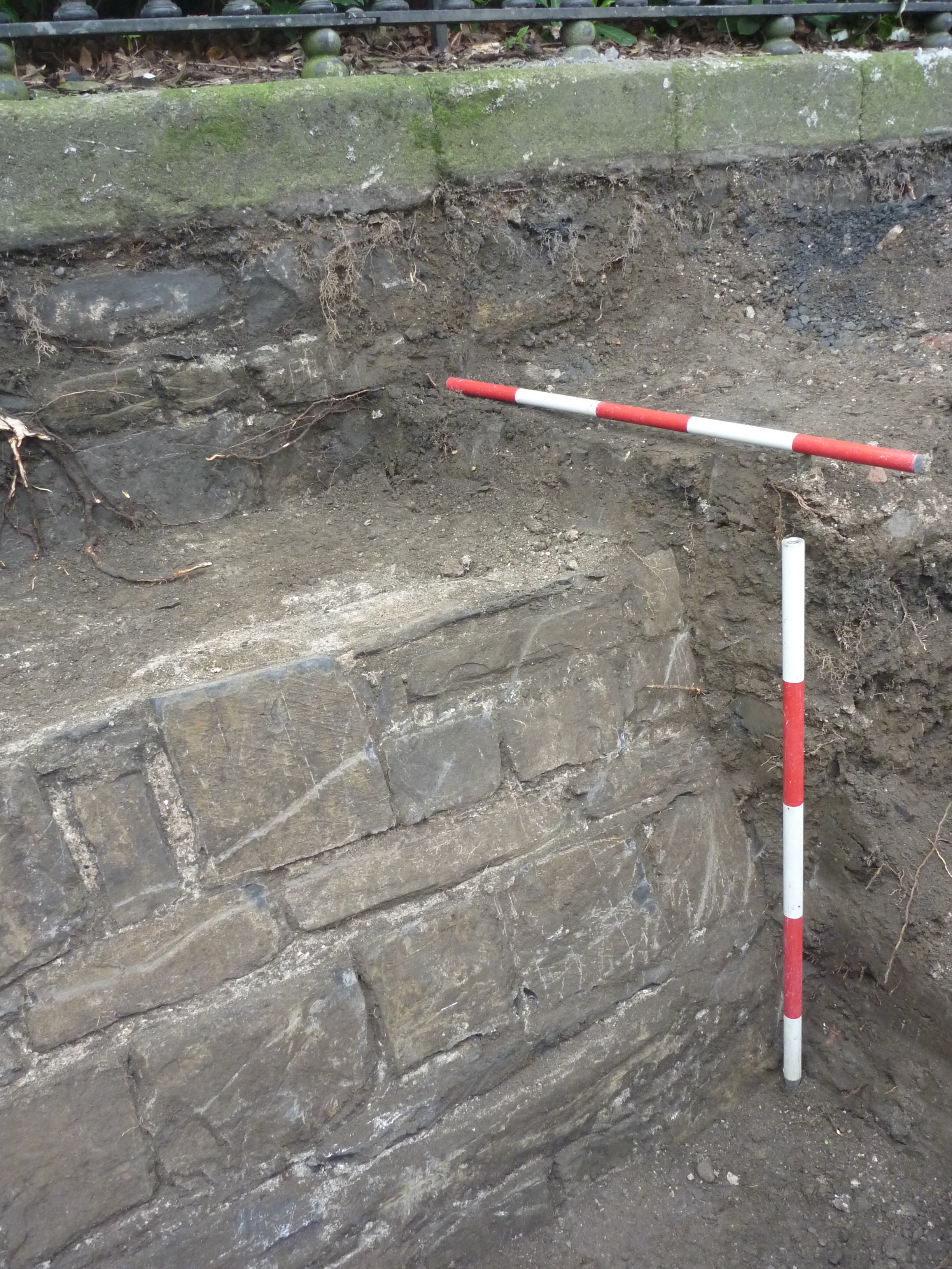
St Stephen's Green Park was established in 1635 when 60 acres of marshland commonage used for grazing was set apart by the then Dublin Corporation for use as a public park. In 1664, when the corporation became short of funding, a mere 27 acres were retained for an enclosed public park with the remaining land sub-divided into 96 plots for residential housing. The lease of these plots would generate money both for park maintenance and city coffers. In 1669, the park was enclosed by a perimeter wall and, in 1670, instructions were issued to further enclose the park with a lime-tree walk and hedging. Owing to the marshy nature of the park, a perimeter drainage ditch was also constructed at this time. The park is first illustrated on Sir Bernard de Gomme's map of 1673, on which the perimeter wall, trees and hedging are clearly depicted (Figure 3). The park is well illustrated in its various guises on subsequent 18th-20th-century maps, as well as within contemporary paintings and documents. These demonstrate that the present-day footprint of the park is smaller than its original 17th century form. This occurred c.1810-17 when the park was remodelled and briefly privatised (1810-1870), at which time its perimeter wall, lime tree-walk and ditch were either demolished or infilled, new perimeter railings and footpaths were installed, and the carriageways of the surrounding streets were widened.
Prior to LCC, invasive archaeological works within St Stephen's Green Park were limited to the monitoring of a small number of geotechnical boreholes and foundation inspection pits. The construction of LCC afforded an opportunity to excavate and record the 17th-century perimeter wall and ditch on the park's west and north sides. For the first time archaeologists could verify the accuracy of contemporary information and the extent of associated remains preserved beneath the modern streetscape (Figures 13 and 14). The works confirmed that once the city's piped drainage and water supply system was installed, there was no longer a need for what some contemporaries described interchangeably as a 'ha-ha' or a 'dirty ditch' (often containing stagnant water and rubbish) to drain the park, allowing it to be infilled and the surrounding streets to be widened. These LCC works created a direct point of reference for the MetroLink station proposed for the park's eastern side.
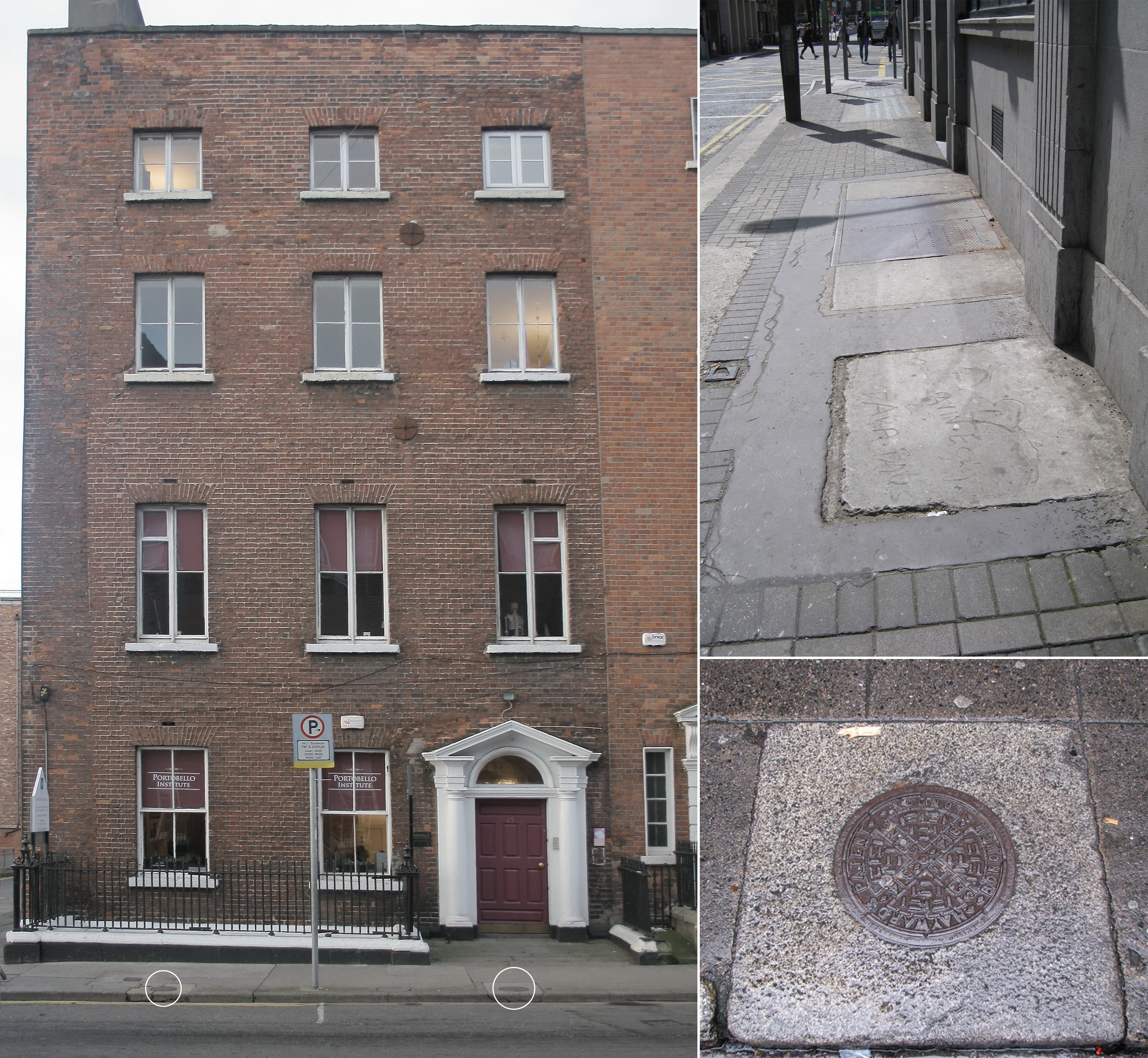
One of the most significant LCC contracts was the Investigation and Treatment of Cellars Works, wherein coal cellars along the LCC alignment were acquired, cleaned, recorded, and infilled in preparation for utility diversion works. These coal cellars are found along the route of the 'new' mid-18th- and 19th-century streets created by the Wide Street Commissioners (WSC) who had compulsory purchased and demolished earlier streets and properties to achieve their required infrastructure vision for Dublin (Figure 10). In addition to building streets, the WSC specified the style and scale of the new houses that came to line them, resulting in the 3-4 storey over basement Georgian landscape of the historic town (Figures 15 and 16). In the late 19th/early 20th century, many of these buildings became overcrowded tenements and suffered large-scale demolition from the 1960s on. Despite this, their associated coal cellars survive relatively intact beneath Dublin's streets as most modern developments stay within the building line and do not extend beneath the footpath where the coal cellars are generally located.
While archaeologists and historians may see a heritage value to recording these coal cellars, as a developer, TII's primary drive for the works is the requirement to identify, record and infill coal cellars beneath the alignment as:
This is an onerous activity, with a typical construction phase coal-cellar acquisition and infilling process outlined in Table 1. As confined spaces with complex Health and Safety restrictions, a cellar team included two archaeologists, two site personnel and one 'overseer/topman', in addition to all gas monitoring/purging and temporary works requirements.
| Activity | Duration |
|---|---|
| Empty and clean cellar in preparation for recording | 2 people/0.5-1 day |
| Heritage and commercial recording | 2 people for each activity/total 0.5 days |
| Diversion of any pre-existing utilities within a cellar | 2 people/1-2 days |
| Construction of block wall to seal cellar from adjoining property (where required) | 2 people/1 day |
| Infilling | 2 people/2 days |
In advance of the LCC works, TII had undertaken a desktop assessment to determine the potential location of all coal cellars along the route and minimise impacts where practicable, focusing on available mid-19th-century Ordnance Survey maps. This led to an estimation of c. 250 coal cellars; in all 393 coal cellars were acquired). The archaeological recording was very valuable as it allowed TII to understand the reasons for this substantial difference, which are as follows:
In response to these lessons learned, TII are undertaking more detailed desktop and exploratory site works for the MetroLink coal cellar impact assessment. All available historic maps are currently undergoing analysis to determine not only how many historic property plots potentially have surviving coal cellars, but also how many phases of cellar construction are likely to be found on each plot.
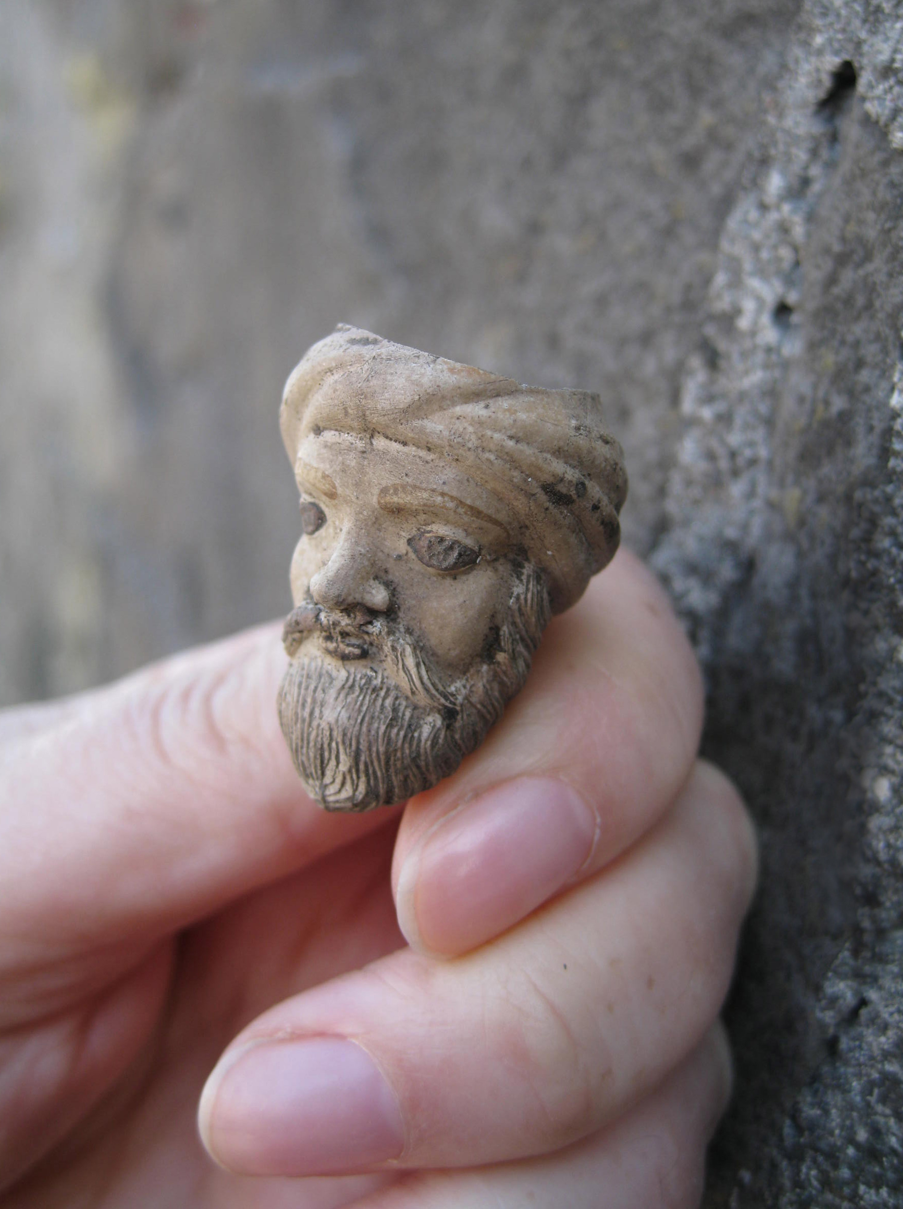
All objects recovered during LCC works were retained for analysis and reporting, and new information was ascertained, such as evidence for a previously unknown dressmakers in the environs of Nassau Street and a sugar factory in the environs of Broadstone/Constitution Hill. However, it is important to bear in mind the nature of the assemblage, not just in terms of its recent age and mass production, but also its extremely fragmented condition, with intact objects being rare and their recovery mainly restricted to the basal deposits of Broadstone Harbour (Figure 17).
On completion of the works, TII and the Contractor's Archaeological Consultants liaised with the National Museum of Ireland (NMI) and it was agreed that the LCC assemblage would not automatically warrant permanent retention for the National Collection. Each object was to be evaluated for retention in terms of information significance. For example, was it a unique or rare find in terms of type or provenance? Essentially, finds that warranted retention were those that increased our understanding of the object or the occupation history of a particular location.
The outcome of these discussions was that the various specialists, in their review of the object assemblage, provided advice to the NMI regarding whether it was to be retained or not, using a three-scale classification (see Table 2). Their proposals were incorporated into each report and TII is in ongoing consultation with the NMI in a final determination as to what is to be retained or disposed of following 'preservation by record'.
| Evaluation | Criteria |
|---|---|
| Highly significant | Artefacts or objects that must be retained in the National Collection and that could not in any reasonable circumstances be disposed of. |
| Moderate significance | Artefacts or objects that would have some potential long-term value to the National Collection, but which could, at the discretion of the National Museum of Ireland, be disposed of subject to 'preservation by record'. |
| Low significance | Artefacts or objects that could be disposed of, at the discretion of the National Museum of Ireland, and for which their 'preservation by record' within the specialist report and the Final Excavation Report is sufficient to mitigate any loss to the National Collection. |
Regarding the human remains recovered from the cholera cemetery, the NMI, on review of the detailed specialist analysis, concluded that the age and comingled nature of the assemblage made it unsuitable for retention in the National Collection. Thus, in December 2022, TII, with the gracious support of Dublin Cemeteries Trust, facilitated the third and final reinterment of these individuals. The burials were interred in 'St Paul's' section of Glasnevin Cemetery, which is defined to the north by the GSWR and to south by the MGWR and Royal Canal. In many ways this proved to be the ideal location for the burials, being the closest burial ground to the original cholera cemetery and forever connecting these individuals to the railway landscape.
Although there is no current legal protection afforded to the canals and railways in Dublin, these are two of the most culturally important and richest sites that helped shape the modern city. Statutory protection does not always equate with how culturally significant a site is, and this must be considered in our approach to the assessment of the significance of impacts and what needs to be archaeologically recorded for posterity.
The LCC works within the mid-17th to 20th-century urban environment has afforded us critical insights into the evolution of the city by providing evidence of the city's response to technological developments in terms of railways, canals, and utilities. The works demonstrated the level of preservation of these remains despite the recurrent impacts of war, changing architectural fashions, and public realm design, and the provision of modern utilities and infrastructure.
In terms of future schemes, the information accumulated from LCC now allows us to work together as unified project teams to accurately predict the nature of cultural heritage remains likely to be identified and to reflect this in the design of our scheme risks and construction contracts.
TII Archaeology and Heritage wish to acknowledge the National Transport Authority; Luas Cross City and MetroLink Design and Construction Teams, TII; National Museum of Ireland; Minister of Housing, Local Government and Heritage; National Monuments Section, Department of Housing, Local Government and Heritage; Rubicon Heritage Ltd; Archaeology and Built Heritage Ltd; Archer Heritage Planning; KN Network Services; GMC Utilities Group; Sisk Steconfer JV; MetroLink Project Conservation Architects (Alastair Coey Architects) and Dublin Cemeteries Trust. I wish to thank Tommy Gallagher, Frank Fallon and Michael Healy of TII whose help and support on site was essential to the undertaking of all cultural heritage works. Thanks also to Phil O'Donaghue, Michael Stanley and Ronan Swan TII, for technical information provided in support of this article.
Internet Archaeology is an open access journal based in the Department of Archaeology, University of York. Except where otherwise noted, content from this work may be used under the terms of the Creative Commons Attribution 3.0 (CC BY) Unported licence, which permits unrestricted use, distribution, and reproduction in any medium, provided that attribution to the author(s), the title of the work, the Internet Archaeology journal and the relevant URL/DOI are given.
Terms and Conditions | Legal Statements | Privacy Policy | Cookies Policy | Citing Internet Archaeology
Internet Archaeology content is preserved for the long term with the Archaeology Data Service (ROR). Help sustain and support open access publication by donating to our Open Access Archaeology Fund.
 Home
Home