Cite this as: Anttiroiko, N. 2024 What Should We Do With These? Challenges related to (semi-)automatically detected sites and features. A note, Internet Archaeology 66. https://doi.org/10.11141/ia.66.6
Recent advances in deep learning techniques and improved availability of high-resolution aerial laser scanning datasets have brought semi-automatic detection of archaeological features within reach of an increasing number of research groups and institutions (see e.g. Anttiroiko et al. 2023; Bonhage et al. 2021; Davis and Lundin 2021; Suh et al. 2021; Snitker et al. 2022; Trier et al. 2021; Verschoof-van der Vaart and Lambers 2019). Such techniques make it possible to detect and extract information about very large numbers of archaeologically relevant features over potentially vast areas in a highly efficient manner and, hence, are likely to have a significant positive impact on the amount and quality of data available to heritage management institutions. However, these techniques also have some limitations and making use of such data in a heritage management context may prove complicated and challenging owing to a lack of guidelines and potential impacts on heritage management workloads and processes.
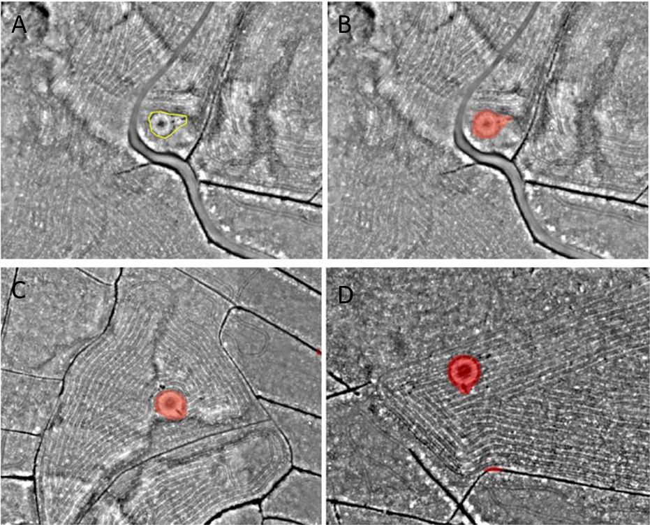
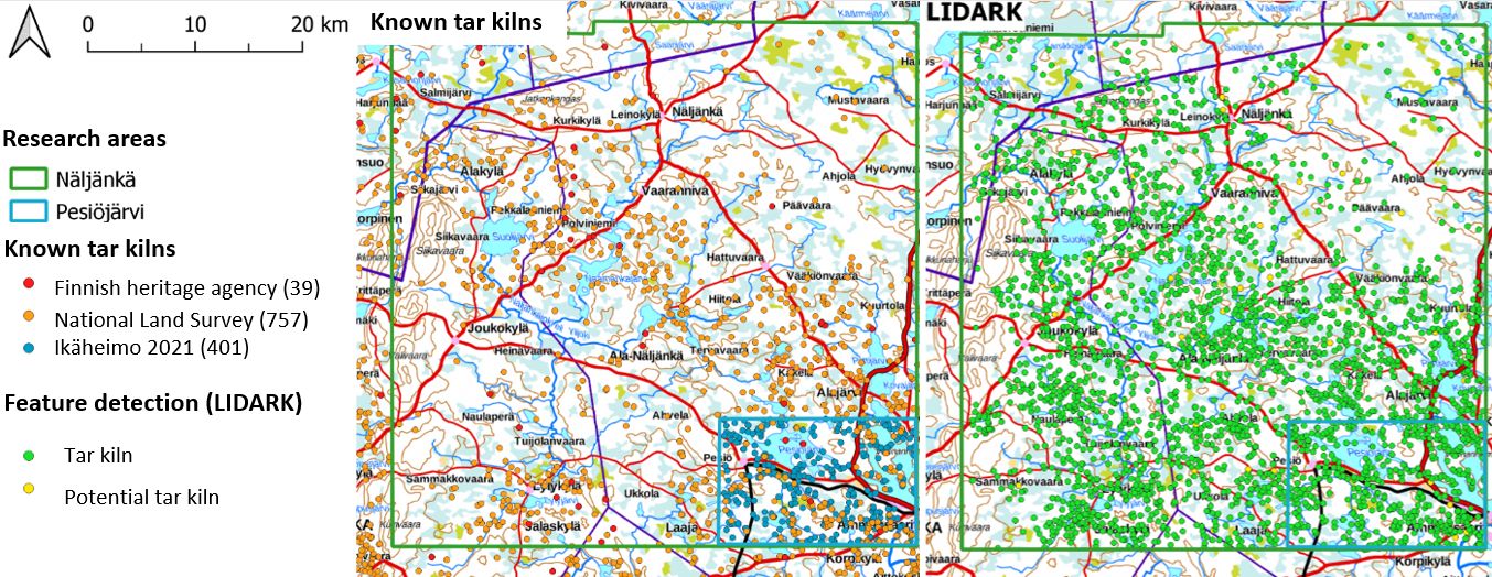
This article seeks to discuss such challenges based on Finnish responses to preliminary feature detection results of the LIDARK-project (see Anttiroiko et al. 2023). The workflow developed in the LIDARK-project is based on using a deep learning model to detect archaeologically relevant features from airborne laser scanning (ALS) data. The ALS dataset provided by the National Land Survey of Finland has an average point density of 5 points per square metre and current coverage of approximately 165,000 square kilometres. Most of the work was focused on archaeological features that are very common and relatively easy to identify in ALS data, such as tar kilns, charcoal kilns, and pitfall trap systems. More than 30,000 archaeological features were detected during the project, most of which belong to previously unknown archaeological sites. To put this number in perspective, there are currently about 61,000 archaeological sites in the Finnish Heritage Agency's database.
As semi-automatic feature detection can clearly be highly effective, it is important that heritage management institutions can make use of and effectively act upon such information. In the context of Finnish legislation, archaeological sites and features that meet the criteria are automatically protected by law from the moment they are identified as such. However, under existing guidelines, it is not clear whether automatically detected sites and features could or should be considered protected as a matter of course, unless their existence can be verified through observations made through archaeological fieldwork or other means. Efforts to find a workable solution to this issue are complicated by potential practical and legal ramifications. For example, ground truthing all detectable tar and charcoal kilns in Finland would take at least 50 years for a single archaeologist, which would be impossible to accomplish within a reasonable timeframe. On the other hand, using and evaluating semi-automatic feature detection data in heritage management contexts requires specialist GIS and remote sensing-related skills and knowledge, which may not be currently available to all institutions. Therefore, there is an urgent need for revised guidelines and training materials to help heritage management institutions make efficient use of feature detection data.
Large numbers of semi-automatically detected features may also cause anxiety about increased workloads for heritage management institutions. However, at the moment, these impacts are poorly understood, as experience of actually using feature detection data in routine heritage management tasks is still fairly limited. In Finland, semi-automatic feature detection data would probably have the greatest impact on forestry-related heritage management tasks, as these often focus on areas where archaeological surveys are not available and rarely involve commissioning new surveys. On the other hand, most planning and land-use related processes that typically involve commissioning archaeological surveys would likely remain largely unaffected, because most of such features would be detected regardless. In any case it has been recognised that keeping the heritage management workload at sustainable levels may require making the affected processes more efficient, possibly through increased use of automation, but also prioritisation of different heritage management tasks.
Semi-automatically detected features have also been debated in the context of a new law on archaeological heritage, which is currently being prepared. Most attention has focused on the potentially large number of relatively recent features, such as tar and charcoal kilns, which has been perceived as problematic because of the potential implications for heritage management workload and the position of landowners. It appears likely that the number of tar and charcoal kilns that would be automatically protected will be limited by using an earlier terminus ante quem cut-off year of 1721 for automatic protection, compared to 1860 for most other features.
While semi-automatic feature detection may present heritage management institutions with tough decisions, it should be stressed that the overall impact is likely to be overwhelmingly positive. The vast amounts of data produced with the help of deep learning techniques allows heritage management institutions to improve their datasets, develop more efficient processes, and make informed decisions when responding to the eventual challenges. However, reaping those benefits also requires heritage management institutions to not only react but actively engage in using, developing, and creating guidelines for the use of semi-automated feature detection techniques in archaeology.
Internet Archaeology is an open access journal based in the Department of Archaeology, University of York. Except where otherwise noted, content from this work may be used under the terms of the Creative Commons Attribution 3.0 (CC BY) Unported licence, which permits unrestricted use, distribution, and reproduction in any medium, provided that attribution to the author(s), the title of the work, the Internet Archaeology journal and the relevant URL/DOI are given.
Terms and Conditions | Legal Statements | Privacy Policy | Cookies Policy | Citing Internet Archaeology
Internet Archaeology content is preserved for the long term with the Archaeology Data Service (ROR). Help sustain and support open access publication by donating to our Open Access Archaeology Fund.
 Home
Home