Cite this as: Lien-Talks, A. 2024 The Ashwell Project: creating an online geospatial community, Internet Archaeology 67. https://doi.org/10.11141/ia.67.12
As the world increasingly embraces digital platforms, archaeologists are adapting their methods of public engagement accordingly (Morgan and Eve 2012). This shift is mirrored in local heritage centres as well, a trend exemplified by The Ashwell Project (The Ashwell Project 2020). Ashwell is a small village situated in the north of Hertfordshire (UK) and is a centre for tangible and intangible heritage, spanning prehistory to the modern-day (North Herts Council 2023). Ashwell's tangible heritage includes monuments and religious sites, punishment and cultural structures, graffiti dating from the time of the Black Death, a series of natural springs used by people since prehistoric times and Romano-British structures, including a temple site for a Roman goddess (Ashwell project 2020; Greef 2015; Jackson and Burleigh 2018). Its intangible heritage includes what is arguably one of the oldest cricket clubs in the country, local pottery artisans, and modern-day recreational activities. In 2020, a collaboration between Ashwell Museum and The University of York was instigated by the author, a community member of Ashwell, as part of the author's Masters degree in Digital Archaeology at the University. The project aimed to investigate whether, through combining intangible with tangible heritage, it could be possible to capture the diversity of heritage and its local significance to inform future heritage projects.
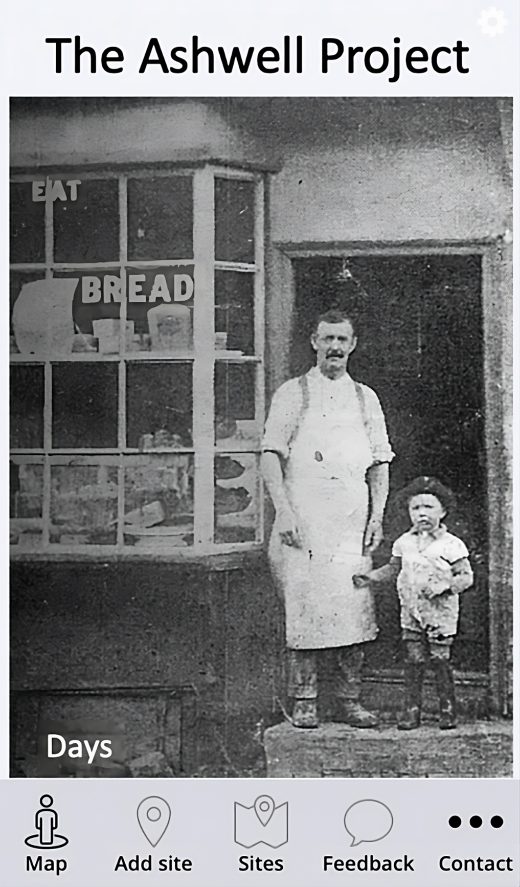
The overall objective of The Ashwell Project (TAP) (Figure 1) was to create a digital community that fostered active engagement in local heritage assets, increase pride and knowledge of local tangible and intangible heritage, and could provide easy access to the breadth of Ashwell's heritage from any digital device. This web-based application would create a living digital record containing photographs and written narratives from the community of Ashwell.
The project sought to function as a proof of concept by gathering local narratives. Ashwell's demographic is a combination of an ageing local population and commuter families who are more recent additions to the area. Overcoming challenges to reach these groups included addressing a somewhat segmented community, limited leisure time for commuter families, and the isolation often experienced by older residents. Unfortunately, isolation among aging populations is a prevalent issue despite efforts such as social prescribing to alleviate it (Baecker et al. 2014). Therefore, it was vital to crucial to design the project with consideration for the distinct needs of these demographics.
To achieve this goal, several objectives were established:
The concept drew inspiration from initiatives such as Hidden Newcastle, Layers of London (Cullum et al. 2020, 5) and Know Your Place West of England (Streich 2017, 3), while also being influenced by the spontaneous emergence of online communities during the COVID-19 pandemic. The central idea was to provide a community space to which individuals could upload, comment, and share their own individual heritage while abiding by social distancing and lockdown measures. A further aim was also to engage a wide audience and foster grassroots education about the village's history. The combination of participatory GIS, crowdsourcing and web application functionality enabled offered a novel understanding of how the use of these techniques can help unlock overlooked heritage assets and produce an online community which shares pride in them (Du et al. 2022).
The project drew on design thinking practice, principally empathising with the users, ideation, definition, prototyping, and testing. The result was a free-to-access geospatial web application. It aimed to capture typically excluded datasets in one digital resource (Smith 2009), educating the users of the platform about local narratives, creating a digital community, and tackling the issues of isolation and social cohesion and community social health due to the COVID-19 pandemic. The datasets within the project included anecdotal and intangible heritage alongside formal tangible heritage datasets, and formed a living digital record. While the application has since been taken offline due to lack of continued funding of the PWA platform, valuable insights have emerged from the project. These include understanding the preferred types of narratives individuals like to share, strategies to encourage older generations to embrace digital applications, the potential of design thinking in enhancing technology adoption, and the effectiveness of Progressive Web Apps in fostering online heritage communities.
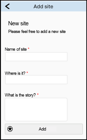
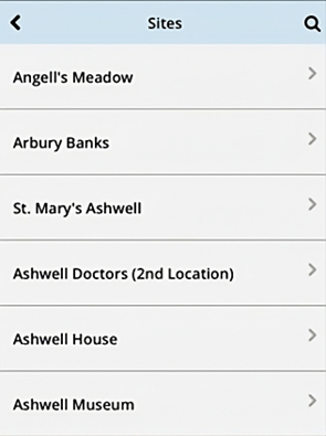
Data collection methods adopted a multi-faceted approach, including engaging through social media with existing heritage groups, later addition of in-person distribution and collection of paper forms at community venues once COVID restrictions had lifted allowing in person attendance at church in June 2020, and enabling direct uploads through the app interface (Figure 2). Physical paper forms were distributed during group discussions in the local church, providing opportunities for those who may be less comfortable using technology such as those from older generations. Social media channels provided a convenient platform for gathering narratives from more digitally active participants (Richardson 2014). Direct app uploads offered another inclusive channel for contributions, ensuring participation from users across various communities (Koukopoulos and Koukopoulos 2018). This combination of approaches facilitated a more comprehensive collection of narratives, potentially broadening the range of heritage subjects captured. Voluntary participation was emphasised and participants had the right to withdraw at any stage.
The methodology applied in TAP underwent ethical review and approval under the University of York's Ethical Guidance Committee. The collected narratives underwent moderation to ensure that the stories submitted did actually relate to Ashwell and compliance with data regulations (e.g. GDPR) while protecting the community members' anonymity. The moderation was carried out by checking that personal data was not disclosed, that the narratives did not contain any profanity and that they were appropriate for all ages.
Geographic Information Systems (GIS) enables the visual display of data for interpretation, analysis, and communication (Conolly and Lake 2006). While traditional GIS has been criticised for its positivist nature and perceived authoritative expertise involved in representing geographical information (O'Sullivan 2006; Pavlovskaya 2006), participatory GIS has emerged as a method to address such issues by democratising GIS through collaboration between diverse stakeholders (such as academics i.e. University of York, professionals i.e. Ashwell Museum, and local community members) to achieve more inclusive and socially just outcomes (Tripathi and Bhattarya 2004; Elwood 2006; Santos et al. 2021). TAP adopted the participatory GIS approach due to its capacity for democratisation aligning with the research objective of inclusivity in capturing diverse forms of intangible heritage. In turn, this allowed the community members themselves to identify heritage assets of particular importance which might not be included in professionally collected heritage lists (Santos et al. 2021; Goussios and Faraslis 2022). Such narratives could consist of lived experiences, cultural traditions, customs, memories, beliefs, and local knowledge connected to place. This democratisation has been used by Historic England in their Missing Pieces project, providing a platform from which individuals could suggest their own heritage assets.
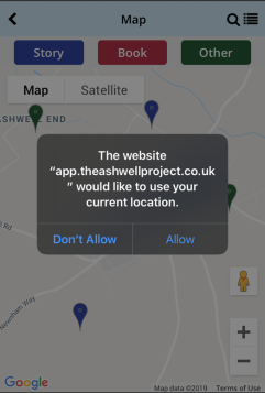
Throughout the project, the capabilities of Progressive Web App (PWAs) were analysed for their potential to facilitate participatory approaches for digitally capturing and disseminating cultural heritage. PWA technology was selected for its ability to provide app-like experiences through a web browser, without needing app store installation or updates. They also offer rapid loading times (Hume 2017). Key technical capabilities of PWAs include enabling features such as push notifications which help inform users of events or new story uploads (possibly helping reach isolated individuals) and navigation (Figure 3) as it enables users to spend time outdoors (abiding by COVID-19 regulations) and encourages exercise, especially important in older populations (Larson et al. 2006; Larson and Wang 2004; Karki 2019). The implementation of 'service workers' (scripts that run in the background of a web application; Pande et al. 2018) and progressive enhancement allows PWAs to maintain reliable performance even with unstable network connectivity, such as is the case in Ashwell, and can provide offline access. Furthermore, PWAs are built using standard web development languages like HTML, CSS, and JavaScript, facilitating responsiveness across diverse devices and screen sizes (Larson and Wang 2004). This meant that the application had straightforward implementation and reduced complexity compared to native mobile applications. Furthermore, making the platform available through a smartphone offered opportunities to immerse new audiences (e.g. young adults) within heritage (Tallon 2008; Jeater 2012; Slavec et al. 2021).
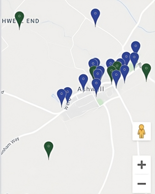
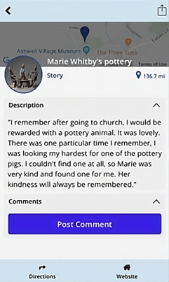
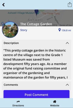
To support TAP's aims of effective capture and dissemination of heritage, user experience design (UX) was also carefully considered, with phenomenological and design thinking approaches utilised. Phenomenology, based on the theory that humans perceive spatial data in similar ways (Thomas 2008; van Dyke 2014; Eve 2017), informed the app's design. The phenomenological approach is most clearly demonstrated by the incorporation of different walking tours of Ashwell's timeline and changing use of land on different themes (Figure 4). Users were guided to traverse key landmarks while spatial storytelling conveyed how inhabitants experienced and interacted with the landscape within living memory.
Design thinking guided the app's co-development process to aid the dissemination and capturing of the community's heritage (Said and Schleppenbach 2004; Brown 2008; Lo Presti and Carli 2023). Public opinions were continually incorporated in the design thinking stages: empathising, defining, ideating, prototyping, testing, implementation, and evaluation. Initial engagement to empathise with end-users helped accurately define the problem statement and objectives for TAP, especially for users like tourist family groups, socially isolated individuals, and student groups. The objectives were addressed through the development of solutions, and were refined through prototyping and the incorporation of public feedback. Iterative small-scale testing with users provided input to refine the app's user experience design.
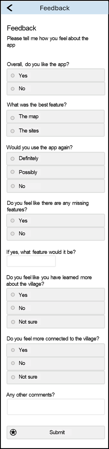
During implementation, final adjustments were made based on user perspectives before public launch. Ongoing evaluation through monitored use and direct surveys enabled continuous app improvements by incorporating the community's input (e.g. Figure 5). Overall, the integration of public opinions within the design thinking process aimed to ensure a user-centric app aligned with the needs, expectations and diverse heritage experiences of Ashwell's targeted users.
To analyse the results, a combination of listing frequency and character length were utilised to determine the level of significance attributed to different types of sites concerning intangible heritage. The average character length can be indicative of a site's significance for intangible heritage, whilst frequency allows for identifying broader trends in community intangible heritage. In this case, sites with an average character length of 60 or fewer characters (<10 words) are considered of limited significance. Those with an average character length between 61 and 100 characters (approximately 10-20 words) are deemed to have some significance, and sites with an average character length exceeding 100 characters (more than 20 words) are regarded as significant. The listing frequency would further contextualise these findings, providing insights into the relative prevalence and importance of different types of sites within the community's intangible heritage.
Early interest in TAP was evident through comments such as 'it's lovely it is happening in Ashwell', and 'it will be lovely to hear the stories that other people may have'. Additional comments suggested Ashwell's rich heritage with 'Ashwell is very historical'. Stories were provided both through in-person events and online platforms (social media and through the PWA). In total, there were 51 places recorded as being culturally significant with 33 associated stories collected in the in-person events, and 29 places recorded with 23 stories using online communication channels. Notably, no stories uploaded to the platform itself. The stories provided covered a range of different topics and were of various lengths (average character length of 210 for social media and 42 for stories collected via paper forms). The stories encompassed various themes including such as places of residence, retail and community facilities, nature, religion and remembrance (war memorials and cemeteries).
Analysis of usage patterns revealed the project's effectiveness across various demographics, and illuminated the diversity of narratives and stories deemed significant by individuals, presenting opportunities to enhance awareness of locally significant heritage, alongside iniatives such as Historic England's Missing Pieces.
While the narratives provided were limited, the results offer valuable insights to consider when scaling up such projects. The data collected by the three strategies enabled analysis of the appropriateness of each approach. Primarily, the majority of data were gathered through in-person events, suggesting that this is the most effective way to capture data from as many individuals as possible. However, the narratives captured using social media had a longer average character length than the paper forms and indicated that online participation may tend to capture more detailed narratives. Future projects should carefully consider the desired data collection format, and where the priority between the quantity or quality of the data lies. For the purposes of this discussion, a 'site' refers to a specific geographical location, while a 'listing' implies a location nominated by the community. A 'narrative' denotes written text accompanying the listing, whereas a 'story' constitutes a particular event recounted by a community member.
The stories submitted convey Ashwell's rich intangible heritage across an array of different intangible heritage categories (Figures 6-8).
Natural landmarks constituted the majority of the results (19) and contained entities such as The Springs (14), woods (2), viewpoints over the village (2), or working in the allotment (1). Associated with these landscapes were narratives of 80 characters in length, indicating that there is some intangible heritage signficance of these natural landscapes. These trends can be taken further when ignoring The Springs (up to 121 characters). The Springs is a well-known landmark in the village, and as such, respondents might feel it should be part of the list rather than having a particular narrative associated with the area. Having the listing included multiple times without an associated narrative illustrates the differences between community heritage and personal heritage, and as such methods to capture both should be encouraged in future projects.
Public facilities rank as the second most common category encompassing sports facilities (Smallgains playing field, the cricket pitch and the Recreation (Rec) ground), built infrastructure (Ashwell School and The Village Hall), and cultivated spaces (The Cottage Garden). On average, the character length was 71, suggesting some significance of these landscapes for intangible heritage. These narratives included: bright murals and close companionships formed at Ashwell Primary School, and bustling events at the Village Hall. These spaces demonstrate how shared experiences in common environments profoundly shape the culture and character of this tight-knit community. Although some of these spaces are listed, places such as Smallgains playing field, the village hall, and recreation ground are not, showing the necessity of encouraging local voices to acknowledge significant sites.
Family homes and historical sites were both listed 12 times, offering a glimpse into the different types of heritage captured within TAP. Historic landmarks like Arbury Banks (7), temple sites (2), and The Lockup, Gardiners Lane Wall, and The Museum (1 apiece) connect modern-day Ashwell to its past and its more traditional heritage legacy. The average character length is 105, and it shows that traditional tangible heritage sites can hold significant intangible heritage, demonstrating the importance of understanding how the local population may consider sites when carrying out heritage research. Additionally, more personal places like family homes and landholdings (Dixies Farm and Ashwell House) add even greater levels of personal history within the intangible heritage. These spaces represent intimate aspects of lineage and personal growth, illustrating the close intertwining of individual intangible heritage with concepts of family and home.
However, despite their significance, family homes and personal addresses exhibited a lower average character length of only 55, indicating that respondents did not include specific narratives for these locations. Possible reasons for this could include the sheer number of personal addresses or the sensitive nature of sharing such information through an app. Future projects should consider how best to balance personal datasets of addresses while ensuring inclusivity in capturing individuals' perceptions of their own identity within intangible heritage.
Retail and places of worship and rest had ten listings each demonstrating the multifaceted roles of built heritage within the community. Places of worship/rest consisted of St Mary's Church (7) and the Congregational church, village graveyard, and war memorial (1 apiece). The relatively high number of listings for St Mary's Church may be attributed to the distribution of paper forms within the church, potentially skewing the proportions. It is essential to consider the location of data collection in future initiatives to mitigate biases. Nonetheless, the average character length here (98) suggests that spirituality plays a significant role in Ashwell's heritage.
In terms of retail, a diverse array of establishments were included: Days of Ashwell (a baker) and the hairdressers (on the High Street) (2), and The Rose and Crown pub, the Ashwell Garage, Marie Whitby's pottery, Crumps (butcher), chemist and Post Office (1 apiece). Despite this diversity, it indicates a common thread of shopping and retail being integral to the cultural identity. With an average character length of 228, retail spaces possess the most detailed intangible heritage narratives. For instance, The Rose and Crown pub symbolizes adulthood and independence, with residents fondly recalling milestone 18th birthday celebrations there. While some results are influenced by two particularly lengthy narratives (974 and 855 characters), and five listings lack an associated narrative, the frequency of inclusion underscores the significant cultural impact of retail establishments on heritage.
A further category, that of farms (Dixies and Blue Gates), underscores Ashwell's connection to its broader rural landscape. The inclusion of these farms illustrates how the broader context of a community also impacts the intangible identity of communities. In the case of the Dixies Farm listing, it is associated with a long narrative further reinforcing the notion that the broader context of communities holds heritage significance for Ashwell's residents.
Overall, the captured narratives show the potential of mixed methodologies to document diverse tangible and intangible heritage. Many of these sites were often associated with narratives, indicating that the technical capabilities deployed in the Ashwell Project app were used to capture detailed heritage information. By digitally collating these intangible heritage treasures (Lien-Talks 2024), not only can cultural resonance be sustained for the future, but insights for bolstering community bonds today can be gathered as well. Given these outcomes observed, expanding efforts to capture local narratives could profoundly benefit other communities too.
The methodology employed within TAP may exhibit a bias towards digitally active and socially connected individuals, potentially overlooking marginalised voices (e.g. isolated older populations) within the community. Nonetheless, it has been argued by Alibhai (2018) that the use of digital technology still offers the potential for greater connectivity between individuals and their community. A recent project by Capital Regional District in Victoria, Canada, utilised maps to mitigate senior social isolation (Alibhai 2018). Such an approach was also used within TAP, and was derived from the idea that 'narrative is…central to collaboration and the building of community identity' (Mulholland and Collins 2002, 1). The local church community found it was a 'lovely opportunity' to discuss their memories with each other. The use of the application showed how the Progressive Web App was able to not only disseminate the intangible and tangible heritage contained within it, but also helped to tackle some of society's wider challenges today.
Narrative is a vital way to learn about the world, providing personal stories and bringing experiences alive for users of all ages by appealing to their imagination. By incorporating community narratives tied to specific locations, TAP was able to demonstrate it is possible to educate a family group about the local heritage in a manner accessible both to children and adults. Similar approaches should be embraced in future initiatives to foster meaningful engagement. The combination of narrative visuals and navigational features enhanced user engagement, echoing the success observed in Mulholland and Collins (2002). Conversations with users revealed how the app had provided an opportunity for households and allowed novel and interesting content while still meeting COVID-19 restrictions on travel and time outside. Consequently, the results suggest that PWAs hold significant potential to disseminate heritage across several generations.
TAP's blended data delivery demonstrated the educational potential of PWAs. As Philip et al. (2013) assert, the combination of factual information with geographical and narrative context has the power to transform information into resonant knowledge. By mapping Ashwell's heritage sites and overlaying the populous' poignant recollections, this digitisation empowered various learning modalities (e.g. if a museum group wished to run a village heritage tour focused on intangible heritage based on architecture). Despite the challenges posed by COVID-19 which hindered in-person activities, TAP highlights the potential of using the functionality of PWAs for place-based education. Expanding these inclusive tools could profoundly benefit teachers and students exploring community heritage across disciplines.
One aspect in which the PWA fell short was in capturing heritage narratives (no stories were uploaded to the PWA). Several reasons may account for this, including the app only being online for a short period of time, social media posts diverting uploads through Google Forms rather than through the application itself or reluctance among users to upload narratives through this channel. It is difficult to assess whether these issues stem from the PWAs themselves.
The Ashwell Project was a novel participatory GIS and crowdsourcing initiative leveraging Progressive Web App technology to capture and disseminate the rich tangible and intangible heritage of the rural English village of Ashwell. Employing an interdisciplinary methodology that merged with design thinking and phenomenology alongside technical implementation, the project aimed to democratise heritage representation, boost community cohesion, and improve accessibility to local culture. Results highlighted the effectiveness of employing diverse narrative collection methods including paper forms, social media and direct app uploads to gather impactful community stories deeply rooted in place and accessible to the widest possible demographic. The captured intangible heritage encompassed a broad spectrum of emotionally resonant landmarks like natural springs, schools, homes and pubs. The capabilities of Progressive Web App were found to be engaging for a diverse audience, ranging from socially isolated seniors to tourist family groups, affirming the potential for flexible and inclusive dissemination strategies.
While app uploads were limited, overall, the positive reception and breadth of stories collected affirm the merit in expanding such participatory digital heritage efforts. Employed more widely, this could profoundly enrich marginalised voices, facilitate intergenerational knowledge transfer, support place-based education, and affirm community identity. The project also highlighted how empathy-driven design thinking can tackle barriers to digital participation. In summary, The Ashwell Project pioneered an innovative methodology synthesising participatory GIS, crowdsourcing, and Progressive Web Apps to advance inclusive, community-anchored heritage engagement. As digital mediation increases, these strategies hold valuable lessons for sustaining living culture. This small project helps chart a path for grassroots digital tools promoting agency and social connection through our shared narratives across space and time.
I would like to express my sincere gratitude to Ashwell Museum and the University of York for their collaboration and support throughout The Ashwell Project. Their contributions were invaluable in making this project a reality. Furthermore, thanks go to the Ashwell community for their insights and stories.
Research for this paper was presented at the Computer Applications in Archaeology International 2022 conference. Attendance was made possible through the support of the Arts and Humanities Research Council's Collaborative Doctoral Partnership Scheme (grant number AH/W002469/1).
I declare no conflict of interest related to the content presented in this research. The study, data analysis, and conclusions have been conducted independently and without any financial, personal, or professional affiliations that could potentially influence the objectivity or integrity of the information provided. There are no associations or financial arrangements with any organisations or individuals that could be perceived as having a vested interest in the outcomes or findings of this article. In the event of any potential conflicts of interest arising in the future, I will promptly disclose them and take appropriate actions to ensure transparency and maintain the highest level of integrity in the research process. I am committed to upholding ethical practices in scientific inquiry and reporting to maintain the credibility and credibility of the research findings.
Post-publication changes: 04/09/24: Minor alterations to acknowledgements made
Internet Archaeology is an open access journal based in the Department of Archaeology, University of York. Except where otherwise noted, content from this work may be used under the terms of the Creative Commons Attribution 3.0 (CC BY) Unported licence, which permits unrestricted use, distribution, and reproduction in any medium, provided that attribution to the author(s), the title of the work, the Internet Archaeology journal and the relevant URL/DOI are given.
Terms and Conditions | Legal Statements | Privacy Policy | Cookies Policy | Citing Internet Archaeology
Internet Archaeology content is preserved for the long term with the Archaeology Data Service (ROR). Help sustain and support open access publication by donating to our Open Access Archaeology Fund.
 Home
Home