Cite this as: Stapley, D. 2025 Towards an Archaeology of Routeways: A case study from the North York Moors National Park, Internet Archaeology 69. https://doi.org/10.11141/ia.69.7
Routeways are complex spaces. They are physical human scale spaces with vastly differing materialities. They are also landscape features of immense scale, components of a complex network that tie together disparate locales. They can also be spaces of layered social meaning, governed by law and convention, locations for social discourse and manifestations of human agency. To complicate this, they often have long lives and structures that are usually considered resistant to archaeological investigation.
To date archaeology has not fully grappled with these differing scales. Routeways are frequently treated as homogenous spaces, their material differences elided, and their importance considered secondary to the sites they are associated with. This is, in part, a consequence of the primacy of mobility within archaeology, with scholarship primarily focusing on proving the fact of movement, rather than examining its processes (Aldred 2020).
That is not to say that routeways have not frequently been the topic of research enquiry. The early 20th century saw significant interest and empirically driven study of routeways. Although some of this early interest was misdirected by the work of Alfred Watkins on ley lines, others such as O.G.S. Crawford, Cyril Fox, and Ivan Margary discussed routeways extensively within their work (Bell and Leary 2020; Margary 1955). Margary's work on routeways has been most actively pursued by later archaeologists, and many studies of routeways focus on the Roman road network. Discussions of routeways sometimes suffer from a 'dark age' mentality, which assigns value to the engineered routeways of the Romans and works on the assumption that engineered routeways did not really exist either before or after. This is best encapsulated by C.T Flower's 1923 assertion that medieval roads made and maintained themselves (1923 , xvi). This was later perpetuated by Hindle (1989 , 6) and belies the complexities inherent in the creation of medieval pathways. Many characteristics of routes have been assumed, including chronology, direction, materiality and use, without substantive investigation (although such assumptions have sometimes been challenged e.g. Harrison (2003) challenging the supposed prehistoric date of the Icknield Way). More recent studies of prehistoric and Romano-British routeways (some specific e.g. Chadwick (2016), some in the peripheries of other larger works e.g. Giles (2000)) have advanced agential and multivariate approaches to the movement landscapes, however the questions raised by these works have yet to be pursued in detail. Discussions of ladder settlements in the Yorkshire Wolds have also touched on routeways as a core organisational component of a newly organised and enclosed Iron Age landscape - expanding analysis of routeways as locations of social discourse (Stoertz 1997; Giles 2000; Atha 2007).
Critically, more recent scholarship has also identified a 'classification problem'; routeways are difficult objects to work with, and the vocabulary for discussing them is borrowed from vernacular language, rather than being constructed for archaeological relevance (Kalayci 2023). How routeways are to be classified also presents a problem. Are they classified by the locations they serve, the things that are conveyed on them, the period in which they emerged or saw use, or their material characteristics? The most commonly drawn distinction is between engineered and erosional routeways, with studies typically considering only one or the other. The implications of these distinctions however have not been fully explored, and only rarely have they been treated together in the same work.
These unclear patterns of categorisation and assumption have created a disunified body of scholarship; erosive routeways have been treated as simply a byproduct of movement, a natural feature almost divorced from human action, agency, or understanding, whereas engineered routes have been overlooked and miscategorised. Studies have often focused on their static furniture, (signposts, milestones, tollhouses) rather than looking at the processes of their use and formation, even though this was the more laborious process (see Quartermain 1999; Morriss 2005).
There is a growing push towards the material investigation of routeways and novel methodologies are driving this change. Efforts to map routeways in ancient landscapes through aerial photography (Stoertz 1997) have now been supplemented by Light Detection and Ranging (LiDAR). This has profoundly affected the ability to map routeways, allowing for unprecedented landscape-scale investigations (Vletter and Speck 2021; Haken 2022). Geographical Information Systems (GIS) have allowed for least-cost path analyses (Bell and Lock 2000), space-time analyses (Seitsonen et al. 2014), and directional visibility analyses (Lewis 2023) yielding materially grounded insight into the social, logistical, and even ceremonial facets of routeways, from a human scale. Absolute dating is also being more widely applied to both engineered (Malim and Hayes 2011) and erosive ways (Bell et al. 2020; Vletter and Spek 2021). The interest in ancient erosive routeways extends beyond archaeological research, with studies examining their geological and natural heritage and recognising their role as socio-natural hybrid features, (Boardman 2013; Zgłobicki et al. 2021) and into the public sphere (Stables 2023).
This article aims to expand on this growing body of scholarship by demonstrating the efficacy of large-scale survey and material approaches to categorisation. Firstly, it presents the results of a community LiDAR survey to identify routeways in the northern part of the North York Moors National Park, which has outlined the remarkable scale and preservation of these features. The results of this survey are then used to propose a typology that classifies these previously homogenised routeway spaces. This typology is based on the physical characteristics of the routeways in question, treating them as monuments worthy of archaeological investigation. From this physical grounding, a brief discussion of chronology, directionality, and intensity follows, suggesting some potential avenues for future research and investigation. It is intended that this materially grounded approach can be expanded, and that the typology can be applied more broadly to the rest of the National Park, and potentially beyond.
This study focuses on a specific region within the north of the North York Moors National Park, primarily situated within the catchment of the River Esk, and covering a diverse area of Sites of Special Scientific Interest (SSSIs) including protected moorland, arable and pasture agriculture, and forestry plantation. It covers a corridor of landscape running from Fylingdales Low Moor in the east, to Guisborough Moor and the National Park boundary in the west. The corridor occupies an interstitial zone in the landscape between the interior dales to the south and the coastal towns to the north, traversing significant differences in elevation from 15 metres to 320 metres above sea level. Several towns and villages are located within or just outside of this area, the most significant population centres currently, and in recent history, being Whitby and Guisborough which sit just outside of the study area and National Park.
LiDAR was undertaken in this area as part of the development conditions in the winter of 2013- 2014 for the Woodsmith Mine in Sneatonthorpe, encompassing the area considered to be under the direct impact of construction and the associated disruption caused by the development. As such this project sits within a scheme of broad landscape-scale mitigation works carried out within the area under impact.
Much of the study area is defined by access to the modern road network, particularly the A171 as a major trunk road. After a preliminary investigation of the LiDAR and other HER data, it became apparent that this major modern road has a significant chronological depth, being flanked by hollow way complexes and met by medieval or post-medieval stone-flagged pathways. Medieval wayside crosses sit alongside the route, and Bronze Age barrows sit at some junctions, hinting at possible prehistoric connections. This investigation revealed the significant survival of large-scale uninterrupted historic routeway features of differing, and perhaps regionally unique, character. Due to the high rate of survival and the lack of information on local historic routeways, a mapping project was developed in association with the National Park Authority to catalogue this archaeological resource. The survey was not purely a mapping exercise but was also designed to facilitate gathering qualitative information about the routeway features and their environs, with the aim of collecting granular data to move beyond 'the fact of movement'.
Volunteers were recruited from a preexisting body of volunteers associated with the National Park volunteer programme to investigate the LiDAR imagery for these features. Many had prior experience of such survey through a similar LiDAR volunteer project conducted through 2020 and 2021 (Frodsham 2021). The group lived locally and had a history of working with the National Park as volunteers in other contexts.
A training session on identifying these features was provided to the volunteers before the distribution of the data. This training consisted of a seminar on the nature of the different routeway features (defined as hollow way, hollow way complex, and trod) and their presentation on LiDAR, followed by an example exercise of identifying routeway features on a paper grid square. For the full survey both Microsoft paint and pen and paper methods were used, dependant on preference of the individual volunteer, and volunteers worked individually. Volunteers were asked to fill in a standard form for each discrete feature they identified - detailing its type, whether it appeared to still be in use, any relationships the feature had with features already identified on the HER, and an additional notes column for any further observations, in order to build qualitative data for each feature.
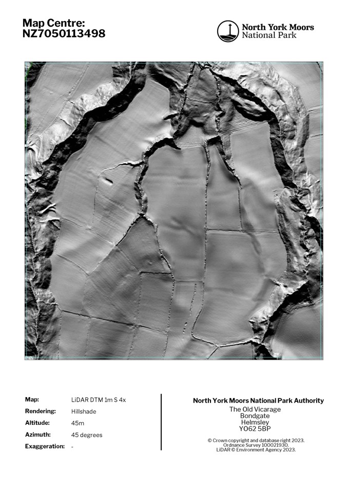
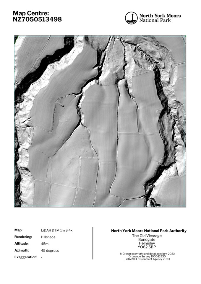
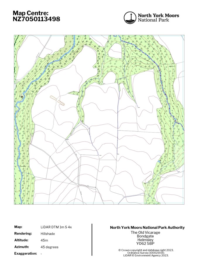
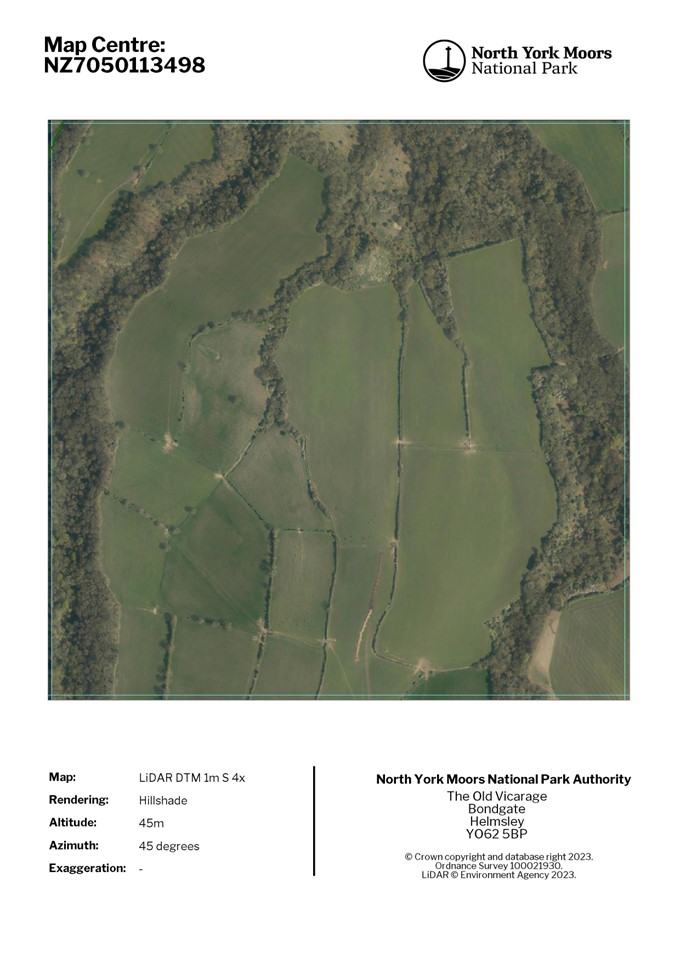
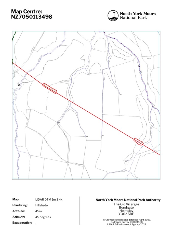
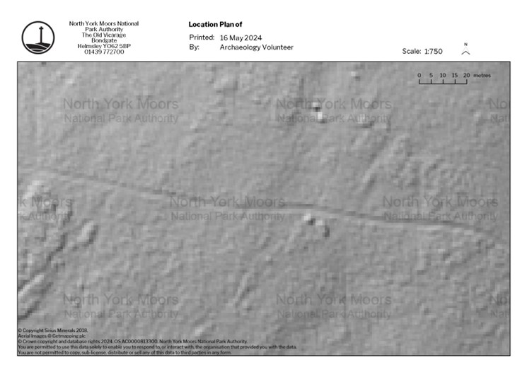
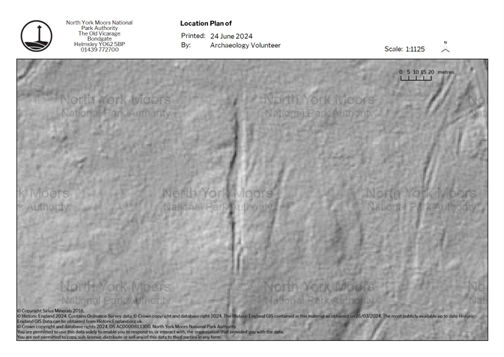
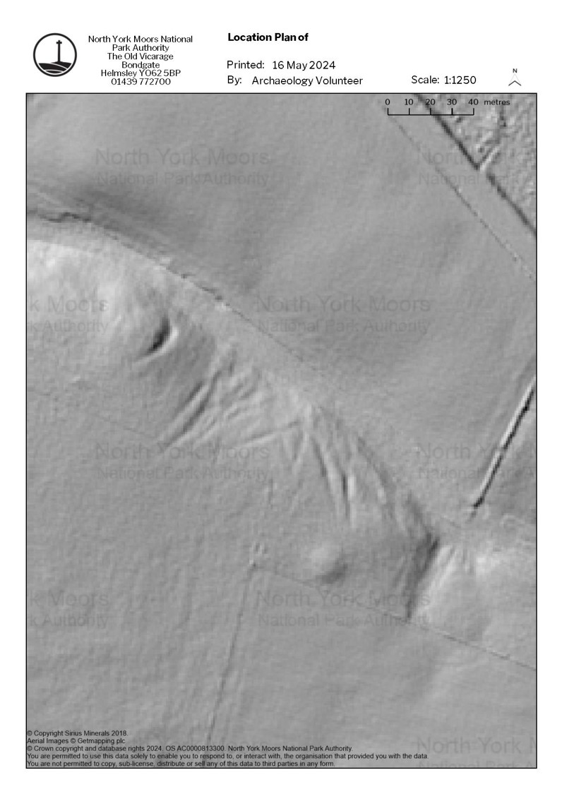
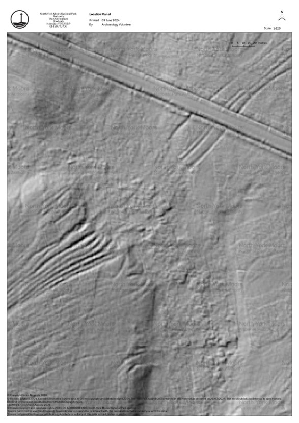
The area was divided into 127 one-kilometre squares, of which 22 were full and 105 were partial, covering a total area of 75 km². One contiguous group of grid squares were distributed to each volunteer. Each square was represented in six different ways. Three were Digital Terrain Model (DTM) hillshades with light projected from the north-east; north-west; and south at one metre resolution (Figure 1). The other three were a map showing feature data from the National Park Historic Environment Record (HER), an Ordnance Survey (OS) map with contour data, and a satellite image. These were included to provide contextual information (Figure 1). Volunteers were also directed towards online resources, such as the National Library of Scotland's Georeferenced maps portal, for additional contextual information from historic mapping.

After the initial paper and digital mapping was completed, the features underwent a verification and amalgamation process by the author, whereby the volunteer-generated data was digitised into GIS and simple database format. False positives, most commonly field boundaries and drainage ditches, were excluded and features that had not been identified were added. Features that ran across multiple squares were amalgamated. A description of each feature was then generated, synthesising the volunteers' observations with additional observations from the author that became apparent during the verification process. Routeways that were exclusively modern, or which were historic but have been significantly disrupted by modern activity, were not mapped. As a result, most roads and farm access tracks currently in use have not been included in the results of the survey, even though the vast majority are apparent on the 1850 OS maps as a mixture of roads, bridleways and footpaths, and are therefore at least 175 years old.
Figure 2 is an interactive image showing the LiDAR and all the features recorded. There are a combination of linear features and polygonal extents. Each feature is embedded with a brief description of its local situation, relationships and any other pertinent information. This reveals the immediate associations and 'microlives' of the features. If the feature has an associated historical or contemporary name this has also been noted in the supplementary information.
In total 449 features were identified through the mapping process and the features were split unevenly, with 61% (273) being complexes, 36% (163) being single hollow ways and 3% (13) being trods (see Table 1). The classifications of these features are at least partially subjective, as there is some overlap between small complexes and individual hollow ways, however this difference remains marked. Only 6% (27) of these features had previously been mapped on the National Park HER https://www.northyorkmoors.org.uk/Historic-Environment-and-cultural-heritage/historic-environment-record so this survey represents a significant increase in identification (Table 1).
Six features are explicitly named on historic maps, or in other sources. The trods are primarily the features that are named, however at least two erosive features are also named. Two features - a trod and a hollow way complex - are named after panniermen, a group of individuals involved in long-distance freight traffic using pack pony trains.
| Identified in mapping survey | Previously identified in National Park HER | Named features | |
| Trod | 13 (3%) | 13 (100%) | 4 (31%) |
| Hollow way | 163 (36%) | 2 (1%) | 1 (0.6%) |
| Hollow way complex | 273 (61%) | 12 (4%) | 1 (0.3%) |
| Total | 449 (100%) | 27 (6%) | 6 (1%) |
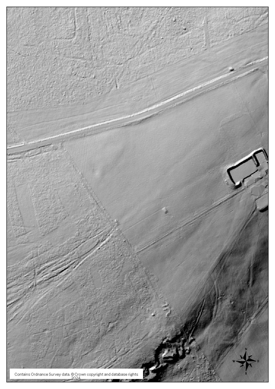
The hollow way complex, known as Pannierman Pots (Figure 3), is particularly interesting. Shown on the 1911 OS map, this feature is described as a footpath with deep scarps along both sides. 'Pots' in this context likely refers to 'pits' or 'potholes', a designation usually applied to topographic features. That this has been paired with the freight-bearing panniermen suggests a connection to their activities. The connection may be causal, conveying in essence the potholes caused by the panniermen. This is not the only evidence that people in the recent past understood the causal factors of hollow way formation, as Gilbert White succinctly and correctly credits 'the traffic of ages and the fretting of water' for the creation of hollow ways near Selborne (White 1789 , 14). How past people used this knowledge to engage with and manage hollow ways as features has yet to be explored archaeologically, the current literature presents them as natural features rather than as features entangled with human agency.
The legacy of these features in the landscape is immense; 249 (55%) features have a direct relationship with part of a current mapped routeway network, whether through vehicular roads or public rights of way.
Table 2 contains a breakdown of these relationships, categorising the survey feature by their interaction with a modern classification. An interaction was recorded where a feature contained or aligned with a modern public right of way. For roads, alignments, junctions and overcuts were recorded. There are 108 (24%) interactions with a public right of way, and 193 (42%) interactions with roads. 50 features relate to both public rights of way and roads, and 2 complexes contain both a bridleway and a footpath, making 52 (11%) features of multiple interaction. This duplication is addressed when discussing total numbers.
| Bridleway | Footpath | Total Public Rights of Way | Road | Total interactions | Features with multiple interactions | Total features with interaction | Total features | |
| Hollow way | 13 (8%) | 10 (6%) | 23 (14%) | 53 (14%) | 76 | 12 (7%) | 64 (39%) | 163 |
| Complex | 43 (16%) | 37 (14%) | 80 (29%) | 127 (46%) | 207 | 35 (13%) | 172 (63%) | 273 |
| Trod | 3 (23%) | 2 (15%) | 5 (38%) | 13 (100%) | 18 | 5 (38%) | 13 (100%) | 13 |
| Total | 59 (13%) | 49 (10%) | 108 (24%) | 193 (42%) | 301 | 52 (11%) | 249 (55%) | 449 |
Remarkably, all the trods retain a relationship with a part of the modern network, most along the entirety of their course. Five trods have multiple associations, and several comprise parts of unclassified unsurfaced roads which vehicles can still legally use. This close association may be artificially induced by the poor survival and detection rate of trods, meaning that only those with close associations to modern routes have survived to be detected in non-intrusive archaeological survey. Nonetheless, it is clear that they have played a role in shaping the modern routeway network. Prospecting for trods along parts of the modern network may prove fruitful.
Complexes have the next highest correlation, with 63% (172) of complexes having at least one legacy feature associated with them, while hollow ways have a much lower rate with only 39% (64) correlation. Additionally, lone hollow ways have a much lower rate of multiple association at 7% (12), compared to complexes at 13% (35), and trods at 38% (5).
The fact that modern bridleways maintain a relationship with historic routes at a greater rate than modern footpaths is also of interest. Given the erosive impact of horses, and their role in long-distance high-volume freight transport, it is unsurprising that bridleways have a greater degree of association with archaeological features. Some footpaths appear to be the continuation of bridleways and their associated complexes, suggesting that the number of horsepaths may have originally been higher (see the alignment between features 171-175 in Figure 2).
Evidently trods and complexes have had a much greater rate of survival in the landscape, indicating that high-use long-term routes have been preserved in the modern network. The A171 road is the most visible modern feature in this regard. In total, 18% of all surveyed features related in some way to that modern road, with a notable bias towards complexes and trods. The modern road appears to be the latest in a series of routes through this east-west corridor over the moorland plateau, with a significant chronological depth.
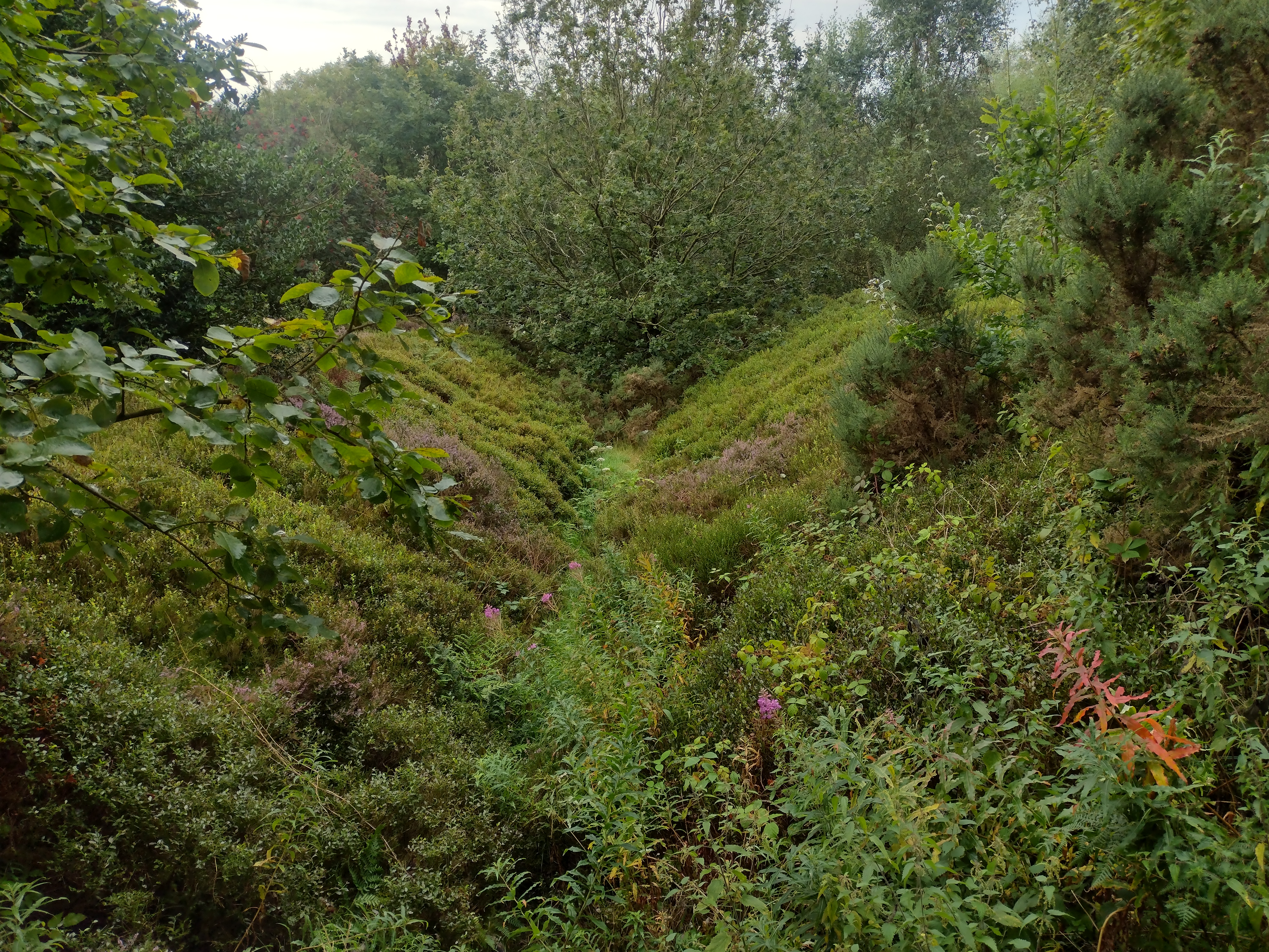
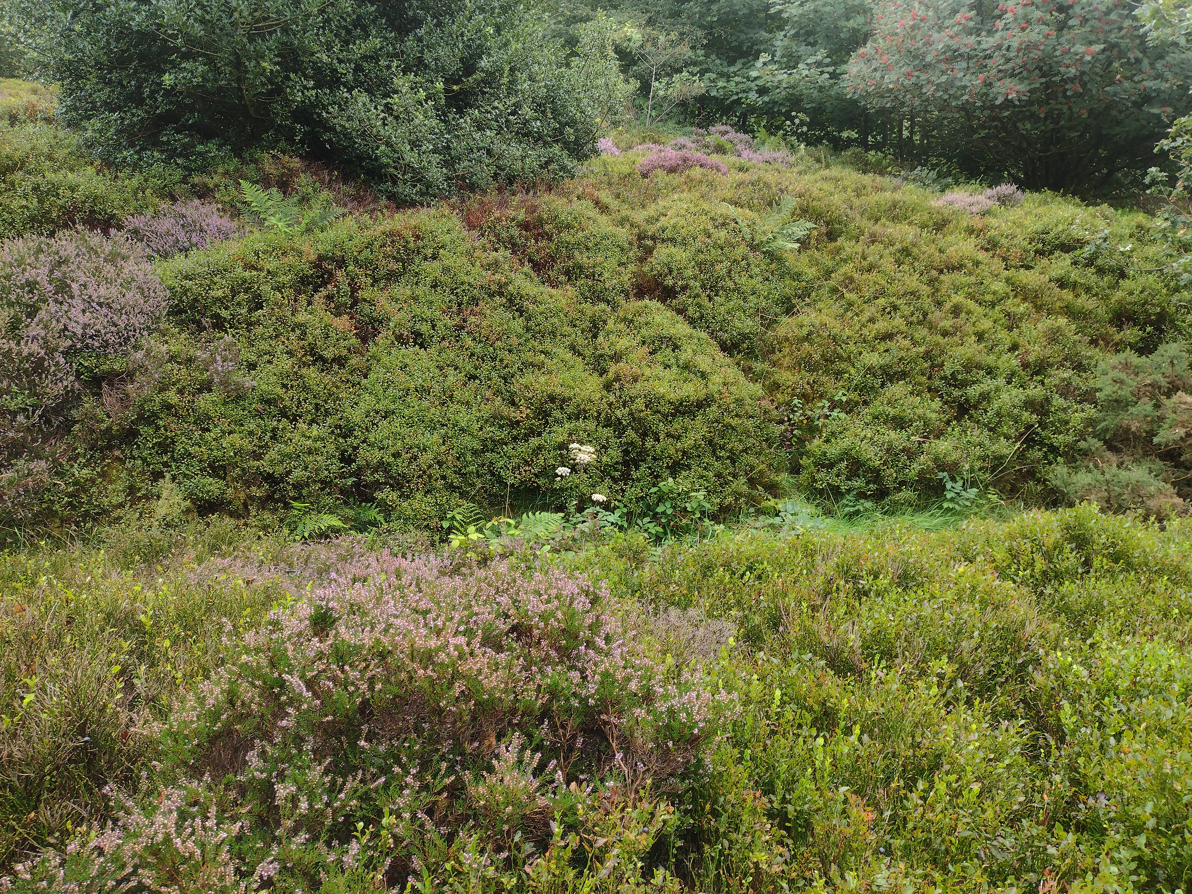
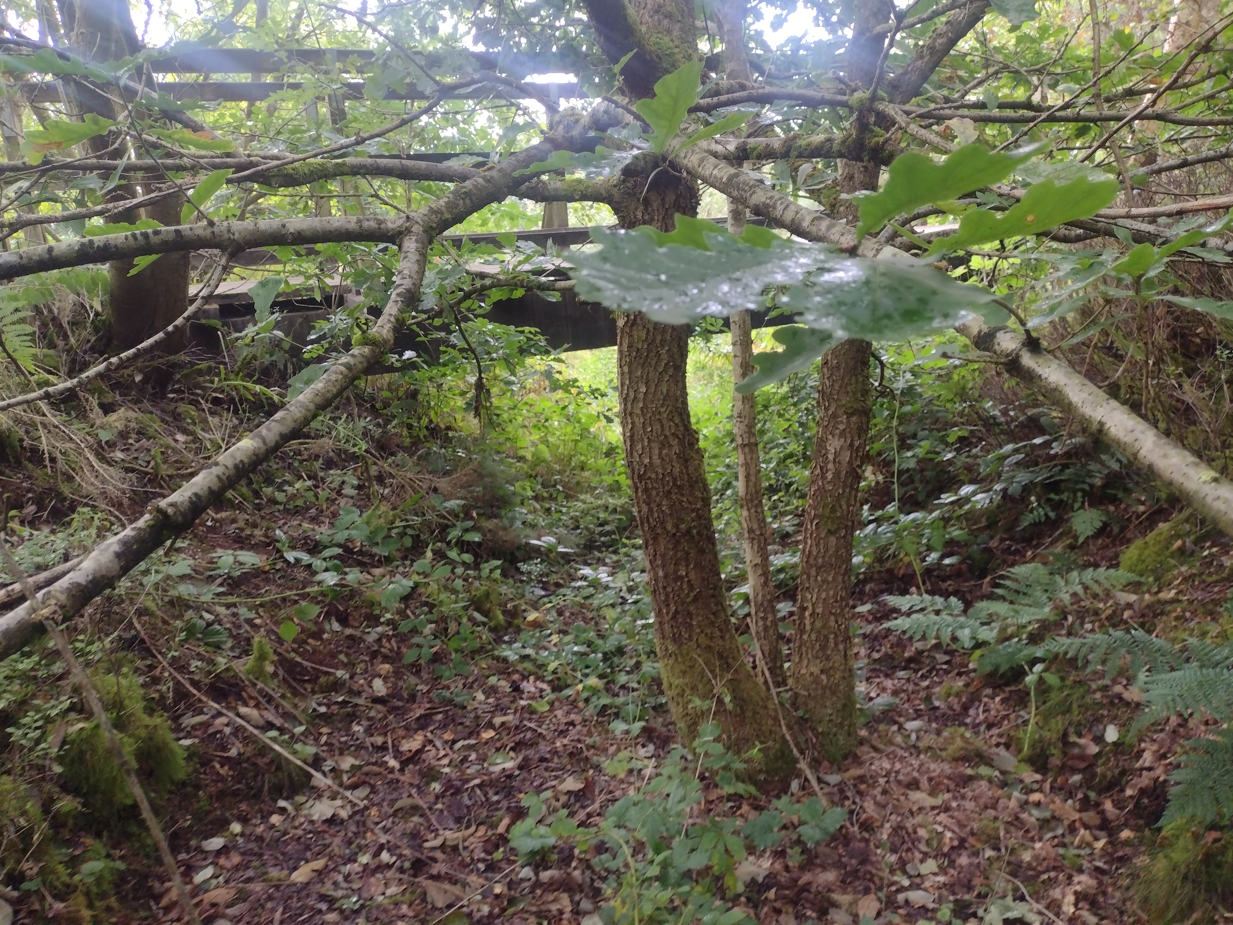
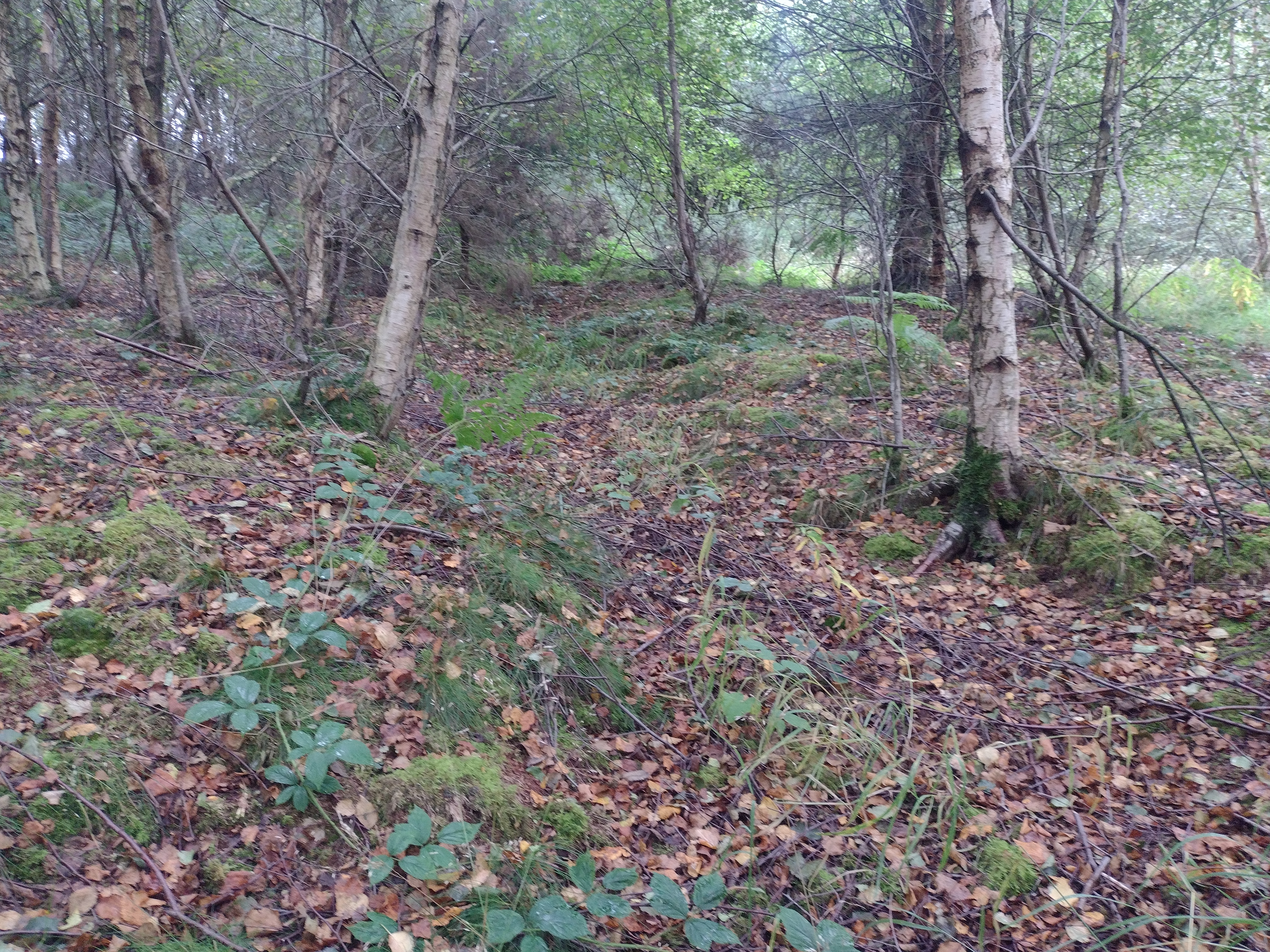
The differential survival of routeway features is also notable. Of the 449 features, 351 (78%) lie wholly or partially within Sites of Special Scientific Interest (SSSIs) or designated Section 3 Moorland (a conservation designation), with an additional 26 (5%) located in managed forest. The remaining 72 (16%)in unprotected areas are either visibly degraded (Figure 4) or found in marginal sections of this landscape such as rill sides.
Formation bias may play a role in visibility, with hollow ways forming more readily and visibly in moorland, free from the restrictions and pressures of an agricultural landscape. However, this does not appear to fully explain the survival bias.
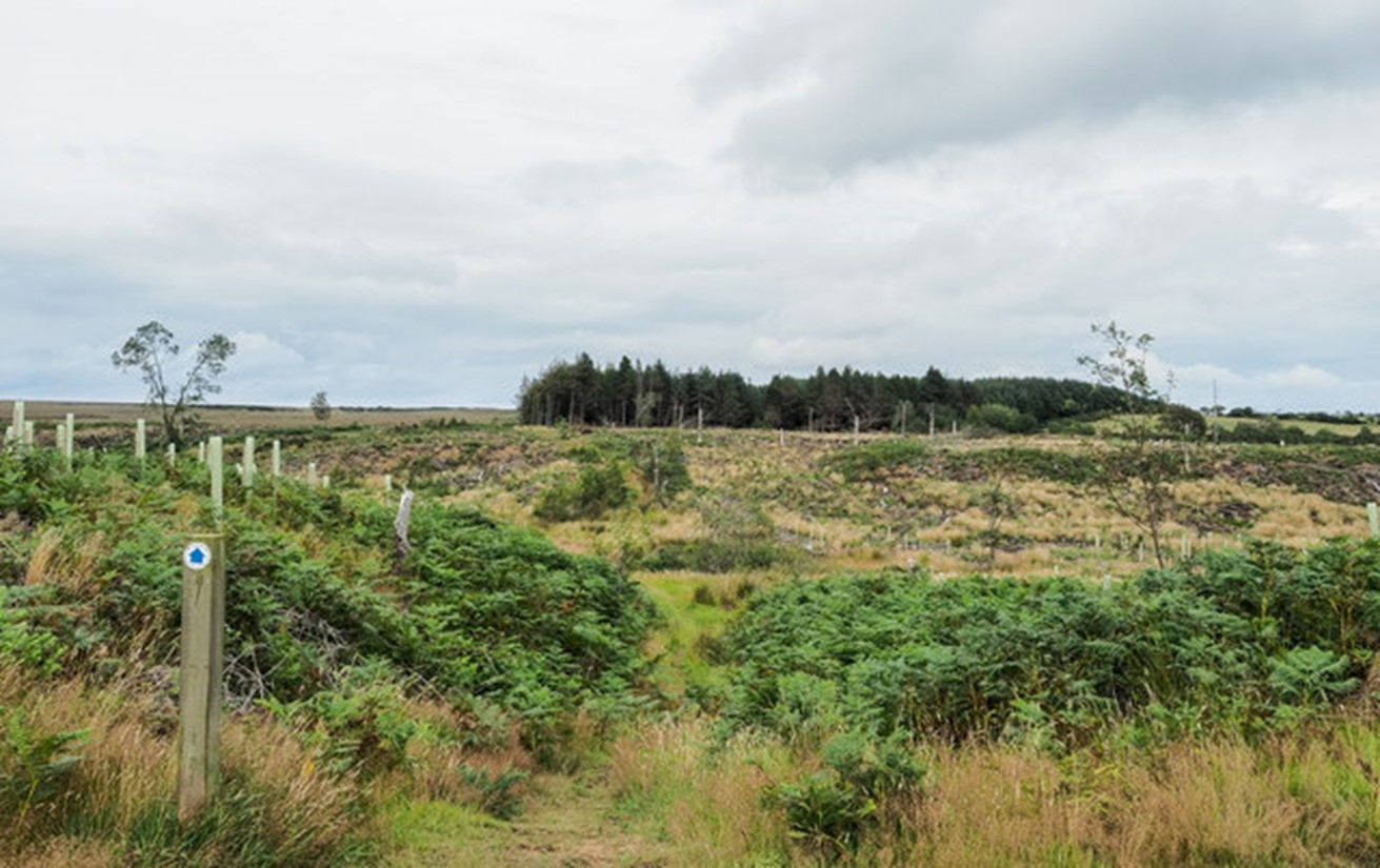
Routeways that have been degraded and disrupted by ploughing related to agriculture and forestry, (Figure 4) are a common occurrence. In many of these cases this activity is recent which suggests that routeways may swiftly disappear under certain landscape management regimes. Many routeways have likely been lost in this fashion, highlighting significant conservation challenges (Zgłobicki et al. 2021).
Trods are less numerous than hollow ways. This may be because trods represent a significant investment of labour and would not have been constructed along every route. They were also created over a shorter timespan compared to erosive routes, so we would expect to see fewer of them than erosive routes. Work in Dartmoor and Wales on similar 'trod' routes revealed that surfacing was not universal for these features (Fleming 2009; 2011); it was applied only where it was needed, again suggesting that we should expect to see fewer of them. Despite the lower overall prevalence, there has also been significant loss, with 80% of trods identified in early 20th century photographs no longer extant in 2008 (Evans 2008). Common causes of this loss include overgrowth, robbing out, sinking into peat, and damage from vehicles and footpath erosion.
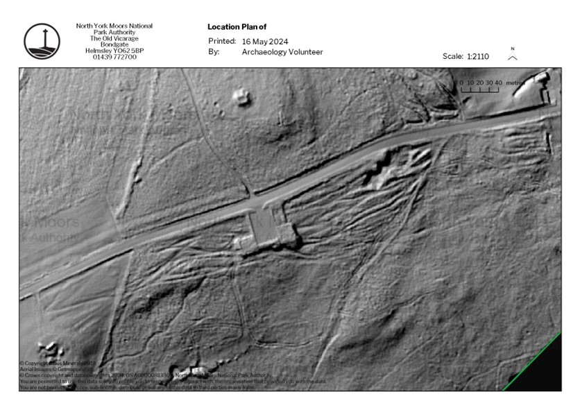
Routeway features exist at a significant scale in the landscape. The largest single continuous complex extends across 26 hectares in area south-west of the Lockwood Beck reservoir (Figure 5). Features on Fylingdales Moor would no doubt exceed this were the survey area to extend further to the south, and modern roads had not heavily truncated them. Nor are routeways lone features. They often exist in dense networks of movement, exhibiting clear relationships to other routeway features (Figure 5). At various times, substantial portions of the landscape were dedicated to movement, resulting in significant erosion in some areas.
The most interesting result from the survey has been the identification of several distinct types of routeway, particularly among hollow ways, where distinct morphologies can be recognised at a landscape scale.
The following discussion touches on a series of pertinent issues. A typology of routeways in the National Park is proposed: first it addresses erosional routes, followed by a discussion of engineered ways and junction arrangements that occur where routeways interact. This is followed by a brief discussion of how directionality, intensity, and chronology of movement can be ascertained in particular circumstances.
The most important development arising from this study has been the identification of different categories of routeway. Routeways suffer from problems in their classification - being landscape scale features, often with significant chronological depth, and varied in form. Being part of a more extensive network, they are difficult to discuss clearly in isolation. This 'classification problem' has been noted by other observers, with the diverse vocabulary, use cases, and legal definitions speaking to these ill-defined boundaries (Kalayci 2023). The current categorisations of historic routeways have been insufficient for archaeological purposes, often due to the categories being drawn either from other disciplines, such as civil engineering, or from vernacular language. Archaeological definitions need to be created to bring a sharp focus to discussions on the archaeologically valuable characteristics of these features.
This study takes a landscape scale approach and discusses how large-scale morphology visible on LiDAR survey can be used to characterise and typologise historic routeway features. There are several distinct categories of routeways within the National Park. Broadly these can be divided into two groups: constructed and erosional routeways. This distinction is critical due to the difference in their formation processes and materiality, which changes the treatment they must undergo archaeologically. In drawing this distinction however, the significant interplay between these features must be noted. Erosional routeways have distinct human interventions, and many constructed routeways overlie erosional routeways, or themselves decay and become erosional routeways, among many other broad interactions. A route may be comprised of both engineered and erosive sections as found by Andrew Fleming in Dartmoor (2011). As such, routeway networks must be treated holistically, but with an understanding of the implications of their morphological differences. It is also important to note that both are manifestations of human agency in the landscape.
While this typology explicitly deals with those features found within the study area within the North York Moors National Park, broader application within Britain is intended. Erosive hollow ways can be found wherever the requisite conditions, suitable geology and significant traffic, are met and narrow stone flagged and cobbled pathways have been reported throughout the UK in South Yorkshire, Derbyshire, Wales, and Dartmoor (Evans 2008; Fleming 2009; Fleming 2011). Clearly, a deeper understanding of morphology would allow comparison of different routes and modes of movement, as well as enhance the study of past mobility.
Singular hollow ways are a varied category. While this discussion focuses on their landscape morphology, it is also essential to consider their morphology at the human scale. The width and depth of an individual way can have significant implications for the pattern and type of past movements that formed it, as well as the landscape in which it formed.
These features are a singular channel, formed by the forces of human and animal traction, and natural erosion of water and of wind. On LiDAR, they present as ditch-like linear features, between 3m to 10m in width, but occasionally with lengths of over a kilometre.
The distribution of widths is bimodal, with one group clustered around 3-4 metres (Figure 6), and a second smaller group focused on 6-8 metres (Figure 7), although this should be confirmed with ground truthing. Such 'double width' hollow ways appear to be stratigraphically later than the other ways, and likely relate to significantly different ways of moving, representing a further subtype. The width may relate to a need for two-way traffic or accommodating vehicles. Some ways appear to have passing places cut into them, presumably to lessen the difficulties of traversing them with vehicles (Figure 7). Pre-existing hollow ways may have been both passively or actively widened for this purpose.
In agricultural landscapes, hollow ways often follow, or are incorporated into, field boundaries becoming confined, whereas in open landscapes they flow more sinuously. Confined ways are often much deeper as traffic is confined to fewer routes. Some hollow way features may have demarcating banks to either side (Leary 2023), however such banks have not been identified from this LiDAR survey. Ground truthing may show signs of hollow way features having been cut, regularised, or otherwise actively modified, and would allow for an exploration of stratigraphic relationships in greater detail.
Islanded hollow ways are like single hollow ways but have minor divergences to their route which fall below the general threshold for more complex arrangements. The phenomenon of 'islanding' occurs when a route splits and quickly rejoins, leaving an island of upstanding ground (Figure 11). Sometimes this island contains a microtopographical obstacle, commonly an anthropogenic feature used as a waymarker (e.g a barrow), or is formed when the main path becomes impassable, and an alternate route is taken (Figure 12). These features likely represent incipient hollow way complexes. Given greater intensity of movement, these islanded ways could form into complexes over time.

Erosional routeways are sometimes gathered into large arrangements of multiple ways. These features have been undifferentiated, being called either 'hollow way complexes' or 'braided hollow ways' interchangeably. In this study, the term 'complex' refers to a broad category of interwoven, interlinked, and gathered arrangements of hollow ways. Two things must be noted; these ways can only form in comparatively unconfined areas; and that multiple complexes may overlap with each other forming a complex palimpsest. The study area contains three kinds of complexes.
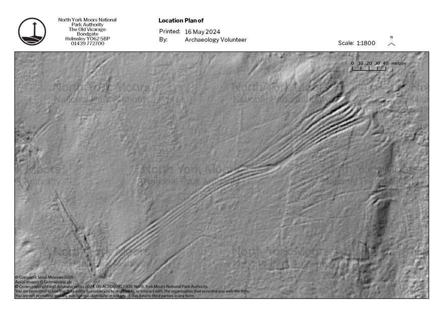
Braided hollow ways are formed by multiple interweaving and interlocking individual hollow ways along the same landscape movement corridor. This forms a LiDAR image reminiscent of river paleochannels, rendered in miniature, or of loosely plaited thread. The phenomenon of islanding is very common in these complexes, forming irregularly sized areas of vegetation among the bare earth or lightly covered paths. These features often cover large extents along the same corridor. Occasionally, braiding can lead to a wide single track along part of the route, where the island between two adjacent tracks eventually erodes away, leaving a short section of wider hollow way.
An open fan comprises a series of non-intersecting hollow ways - diverging significantly from each other in the process and dissipating into open ground - taking the shape of a fan. The ways are interspersed with regularised islands. Typically, these features are situated at a pinch point, usually a ford, gateway or suitable crossing over an incline.
Such fans may sometimes be incorporated into part of a much longer routeway where they reconnect to a single route or form part of a much larger complex. In the case of fords, such fanned complexes usually have a mirror feature, forming an hourglass complex (Figure 14). There are instances where two individual fans may intersect allowing for a more detailed stratigraphic analysis of these features (Figure 14).
Closed fans comprise multiple tightly bunched and parallel individual hollow ways (Figure 15). These individual hollow ways are usually narrow and shallow, suggesting that they were not primarily formed by vehicular use but rather by pedestrians and livestock. As will be discussed in more detail below, they appear to be stratigraphically earlier than other routeway features, suggesting that ways of moving changed, thus routeways with them. They more frequently occur as part of longer-distance complex routes and are typically heavily overwritten by later developments. They are commonly superimposed by braided hollow ways, the beginning of which can be seen in Figure 15.
Closed fans appear to be the result of highly structured movement patterns but what these might be is currently unclear and requires further investigation. One potential explanation is that they are high-capacity drove routes, used when necessary to accommodate large volumes of traffic travelling in the same direction, and to maintain control over large amounts of livestock. Another potential explanation lies in managing the hollow ways as a feature. Communities may have strictly demarcated them due to the role that they played in landscape erosion and degradation - and underwent processes of active closure to prevent them from becoming too deeply scoured and deleterious to the landscape before a secondary way was demarcated adjacent to the closed way. This process may also occur naturally, as a deep way becomes difficult to use, its line provides a useful guide for traffic, and a secondary hollow way eventually forms alongside the previous feature. Nonetheless, they remain a conscious and significant element in the landscape.
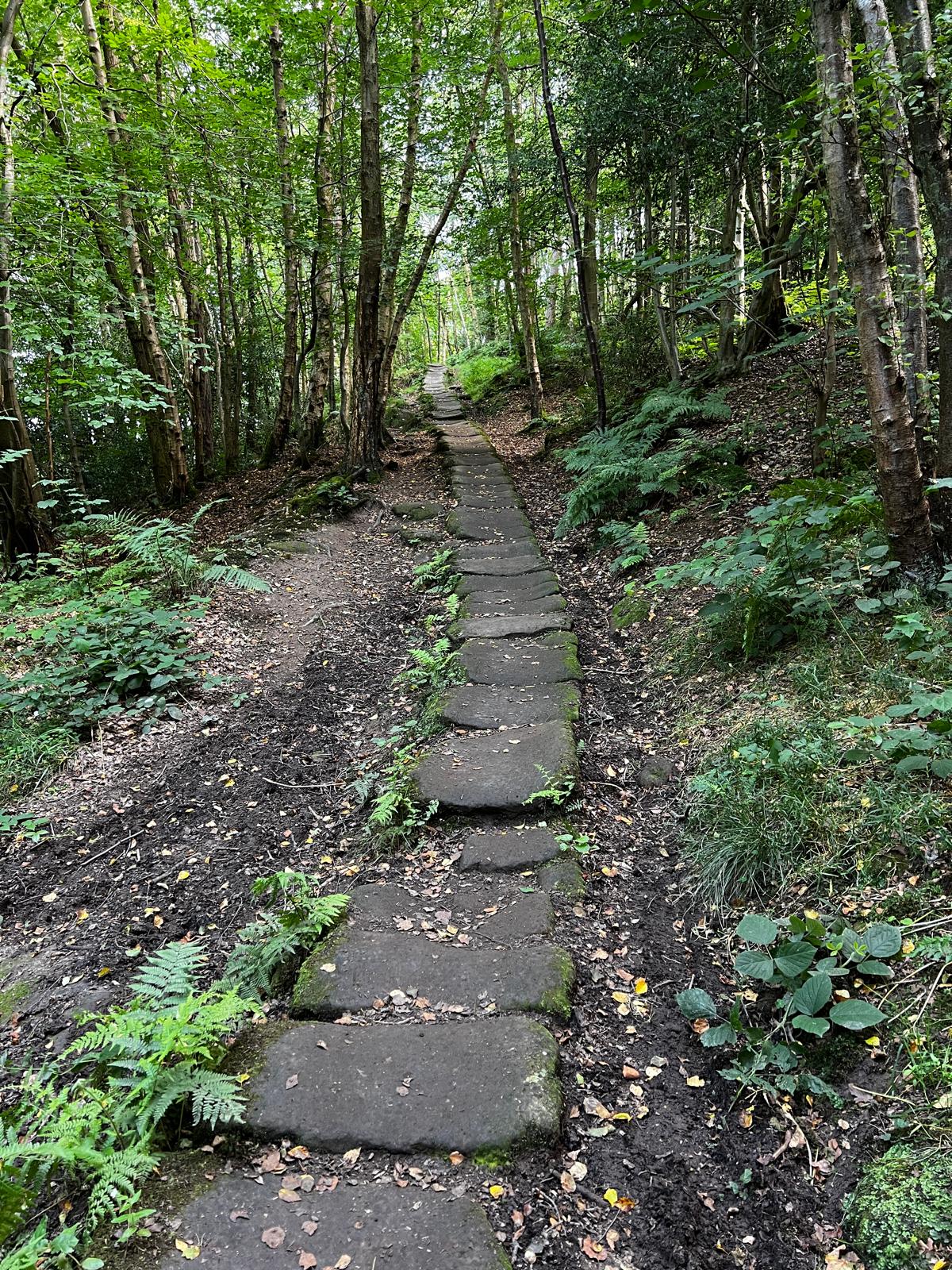
Several paved pathways exist within the study area. These paths are known today as trods, although it appears that this term may have originally referred to long-distance footpaths in general. Some specific work has been completed on these features. Evans (2008) identifies trods as paths constructed of flagstones, 'typically 500mm wide by 450mm long and 130mm thick', although he also notes that there is significant variability depending on availability of local material. Hayes reports a more diverse morphology, detailing earthworks that are visible alongside trods including embankments, drainage ditches, retaining works, and cobbled road surfaces (Hayes 1988).
Evans anecdotally notes that these pathways are similar in construction to others described in Wales, and in the dales of South Yorkshire and Derbyshire where they are identified as packhorse roads. They bear a remarkable similarity to the medieval routeways identified by Fleming in Wales and Dartmoor, with the single difference being that these ways are cobbled, rather than paved (Fleming 2009; 2011). The 17th century travel writer Celia Fiennes described such paved ways alongside carriage roads to the south of Wigan, and the need to use them in inclement conditions (Morriss 2005). These similarities suggest that the 'trod' type is not confined to the National Park but is more common in England and Wales than has been recognised from previous piecemeal studies.
These paved routes are subject to a varied vocabulary, and have been called causeways, causeys, saddleroads, horsepaths in the early modern sources, and calcetus (likely related to causey) and flaga in medieval Latin texts (Fleming 2011; Evans 2008; Hayes 1988; Wheatley 2008). Saddleroad and horsepath, and the correlation of trods with modern bridleways, suggests a particular association of these routes with horse travel. The chronological and linguistic range of this vocabulary suggests that trods have a medieval origin. Unlike most hollow ways, trods are often known by specific names, commonly relating to the users of the way. In the study area, one refers to Panniermen [245], and one to Quakers [392], groups that were likely not present at the time the trods were constructed. This suggests that the names may have had a later origin than the routes themselves.
The trods appear to be the preferred way for heavy commercial traffic along specific routes prior to the railway network reaching its most effective extent in the 1860s. Contemporary interviews indicate that the advent of the railway didn't markedly increase the speed of travel to nearby destinations such as York, but that it radically changed the volume of goods that could be sent away (Evans 2008).
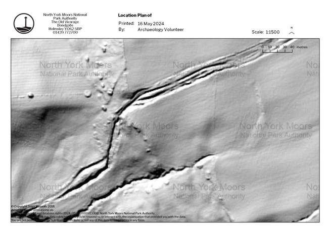
On LiDAR, these flagged ways are difficult to identify. In the cases where they are present, they are similar to shallow single hollow ways but are distinguished by being more sharply defined and have a straighter course (Figure 16). This is most visible where a trod takes a distinct angled course (at corners), whereas a hollow way may have taken a more sinuous route. In some cases, there is evidence of ground levelling, either embanking or cutting, to ease the course (Figure 17).
Trods are also often closely associated with hollow ways and hollow way complexes, forming mixed engineered and erosional complexes (Figure 16). Notably many of these features have been substantially disrupted in the last century, either being buried, or quarried for their stone, which may make the detection of these features more difficult. A comparison of photographs of trods from the late 19th and early 20th centuries with their in situ state on the ground in 2008 led Evans (2008) to the conclusion that 80% of the trod sections pictured were no longer extant. Observers from the early 1800s to the present time have noted the continued loss of these features as different means of personal movement and freight transportation have emerged (Atkinson 1890; Sewell 1923; Hayes 1998; Evans 2008; Leary 2023). The antiquarian Reverend Atkinson notes how, even by 1890, many trods in Danby parish were buried, and that the knowledge of their location was waning. He details how he 'prodded out some score of yards of its course … with a sword-stick, for it is grown over in most places … to the depth of ten or twelve inches' (Atkinson 1890 , 205).
It would seem necessary therefore to understand how a removed, disturbed, buried, or destroyed trod may present in both remote sensing and the archaeological record in order to reconstruct the past network better. A methodology focused on probing or coring, following Atkinson's example, may also be useful in identifying the course of these features beneath the peat, detecting both the road surface and subsurface associated with the trods, while ensuring minimal disruption to the natural environment and archaeology.
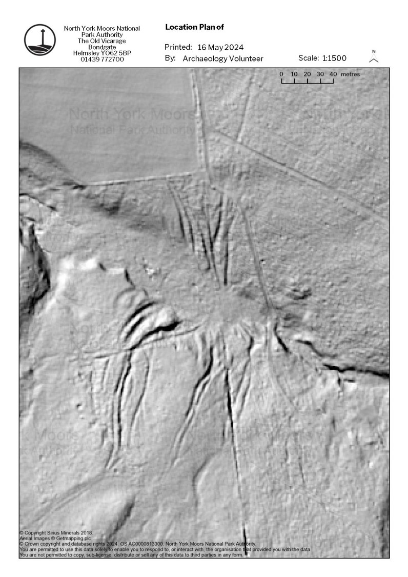
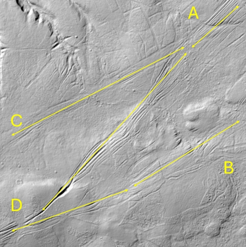
Junctions are where two or more routeway features along different movement axes meet. These locations offer the opportunity to conduct stratigraphic analyses in an attempt to ascertain the relationship between different routeway features. At these locations, engineered and erosive ways may meet and intersect with each other. As such these features are morphologically diverse and complex, being composed of different features and are best understood on their own merits. Junctions may be defined separately by the number of entry/exit points into the junction (their most important characteristic) as it can inform us of the directionality of past movement (Figure 18). Analysing these interchanges allows examination of the flows of traffic within past routeway complexes, most specifically for erosional routeways. In Figure 18, we see a junction formed of several hollow way complexes on Fylingdales Moor, representing a significant interchange of movement. There are four entry/exit points for this junction labelled alphabetically. Here, we can see that there is a clear interchange between 'B' and 'D', and 'A' and 'C', as well as between 'A' and 'D'. There is no apparent desire line interchange between 'C' and 'D' and 'A' and 'B' meaning that a comparatively insignificant amount of traffic moved between these locations. If entry and exit locations can be correlated to routes to or from different specific locations, such as quarries or settlements, we may begin to understand flows and intensities of traffic in the past in greater detail.
As well as junctions, another way of assessing directionality is by analysing hollow ways that cross inclines. It has been noted in studies of footpath erosion that walking downhill induces more erosion than travelling uphill (Coleman 1981). This may provide insight into whether routes were used more intensively in one direction than in another and may be particularly useful when a routeway crosses a narrow valley, so that the two slopes can be seen in close proximity.
Figure 19 demonstrates an example of this, where approximately fifteen parallel hollow ways enter the rill, while only three emerge, indicating that there may have been very significant uni-directional traffic travelling north-east in this area (Figure 19).
This complex runs from the interior of the National Park in the west towards the coast in the east, indicating perhaps that the unidirectionality relates to the transport of freight and livestock to coastal markets such as Robin Hoods Bay and Whitby, while comparatively lighter or lesser traffic returned westwards. This kind of analysis may have a broader application within the study area and provide a further insight into the flows of movement in the past.
Intensity of use is another interesting facet of hollow way formation. As a rule of thumb, deeper ways and larger complexes represent a greater history of use. The three main human factors that control this apparent intensity would seem to be the volume of traffic, frequency of traffic (for instance whether movements are constant but low volume, or stochastic and high volume), and timespan of use. Further investigation is needed to establish a method for controlling for natural factors, such as slope, drainage, and underlying geology, to better understand the anthropogenic elements of erosive routeway formation, and more precisely characterise the traffic that created these features.
Carrying out this survey on the landscape scale has also been helpful in obtaining relative chronology from stratigraphic information, and in identifying locations where absolute chronological data could be obtained.
Routes can be relatively dated where they interact stratigraphically with other features. These interactions are threefold; a direct association, overcutting, or being crosscut. Direct associations, suggest a date concurrent with the feature with which it is associated. This association can only be truly drawn if a routeway terminates within a feature. If the way continues beyond the feature, the potential exists that it predates a roadside feature that subsequently enveloped it. This relationship should be relatively common, as people are far more likely to construct a feature or recognise a resource near a pre-existing means of access.
Where routes overcut a feature, they can provide a date after which the way is formed, and for features that cut through or block routes they can provide mark a point of closure. If there is already an established absolute chronology for the feature, it will be possible to relate the formation or construction of routeways to a known chronology, narrowing the chronological scope. There is significant scope to deploy such relative dating, but this has yet to be widely applied, despite demonstrated utility (Haken 2022).
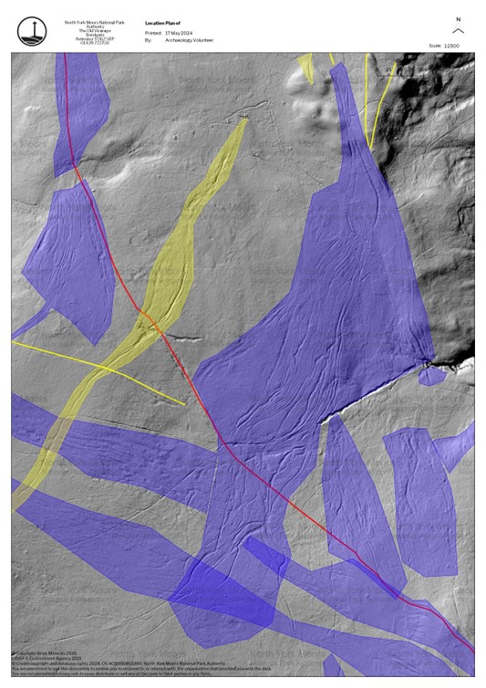
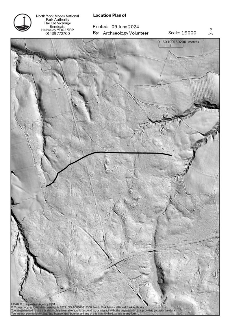
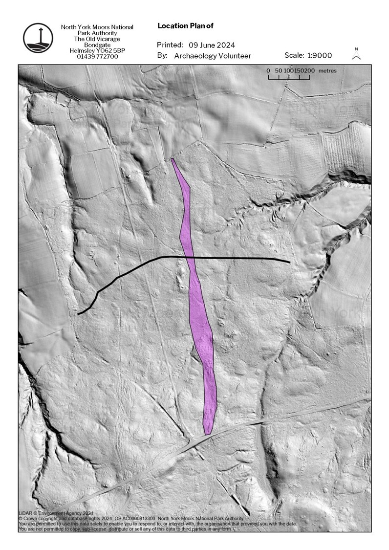
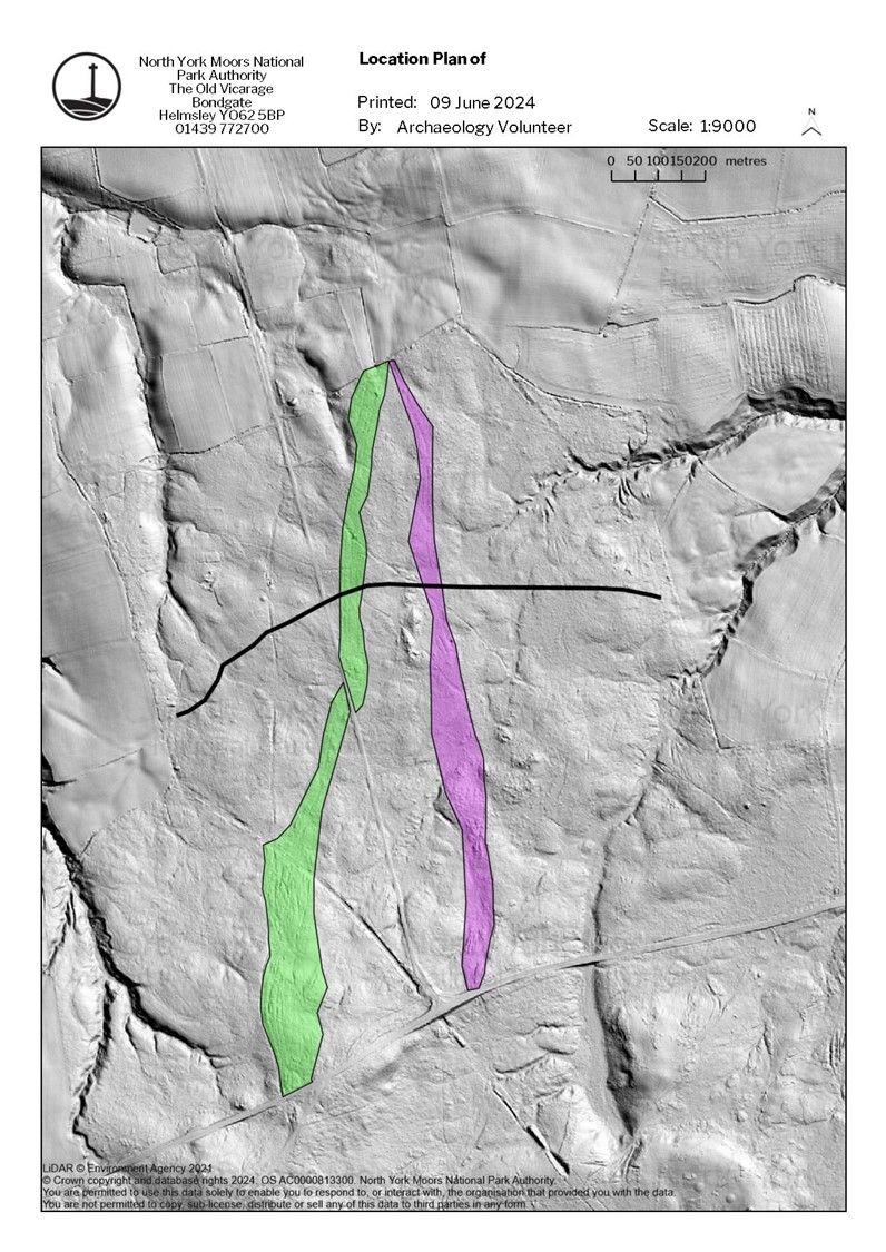
Liverton Moor provides a significant case study in this regard. Through a combination of tracing routes from historic maps, and examining stratigraphic relationships, it becomes possible to infer a chronology. Figure 20 shows that the first phased feature is an earthwork bank (shown as a black line) that crosses the moorland on an east-west axis. This bank has not been definitively dated, but it would appear to be the earliest feature, as it is truncated by all later developments in term of the routeways that cross it.
Phase 1 (purple) appears to be the first routeway development - one of several parallel routes traversing north-south (Figure 21). The feature has a high incidence of closed fanning. This routeway has been obstructed by a significant peat accumulation in several areas (Figure 21). This accumulation would likely have rendered the way impassable and lead to its closure. The way appears to follow the historic parish boundary between Wapley and Liverton, which suggests that the routeway was used at the same time that the boundaries were laid down.
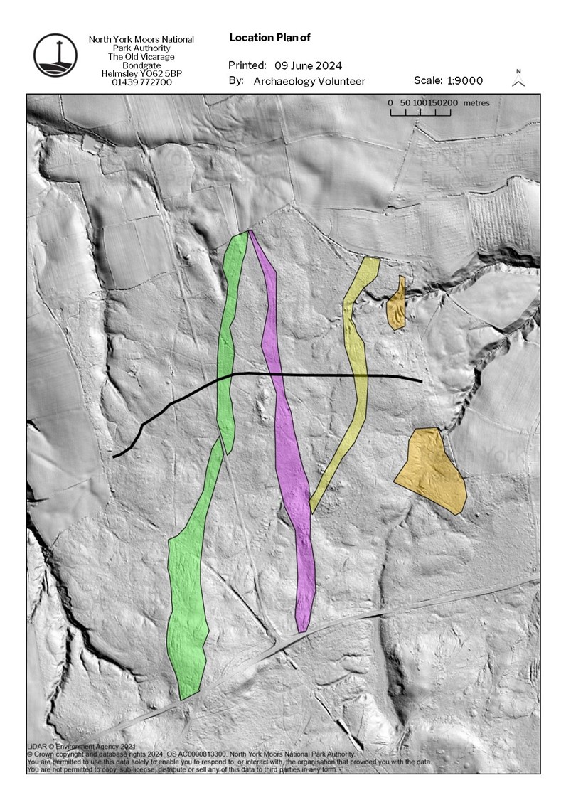
Phase 2 (shown in green) stems from the same origin point at the north of the moor as Phase 1, ultimately reconnecting with each other beyond the bounds of the study area, demonstrating that they are alternate routes of each other (Figure 22). This feature has been judged to be the second phase as it takes a higher route and runs through fewer instances of peat accumulation, suggesting that it formed after the period of peat accumulation that led to the closure of Phase 1. These features likely co-existed, but it seems probable that Phase 2 was initiated and continued later than Phase 1. The southernmost elements of Phase 1 and Phase 2 remained in use as shown on the 1853 OS map, however the northern sections were not included, having fallen out of use.
Phase 3 (yellow) cuts into and utilises the Phase 1 complex in the south of the moor before it diverges to the northeast (Figure 23). It aligns with the deserted medieval village of Wapley to the northeast, towards which a route is shown on the 1853 map. As it cuts the phase 1 complex it is later, and the association with a medieval village would appear to place this feature as forming within the medieval period. Several other features have been included as putative phase 3 (orange) due to their morphology and scale and inclusion on 1853 mapping, implying a later formation consistent with the Wapley route.
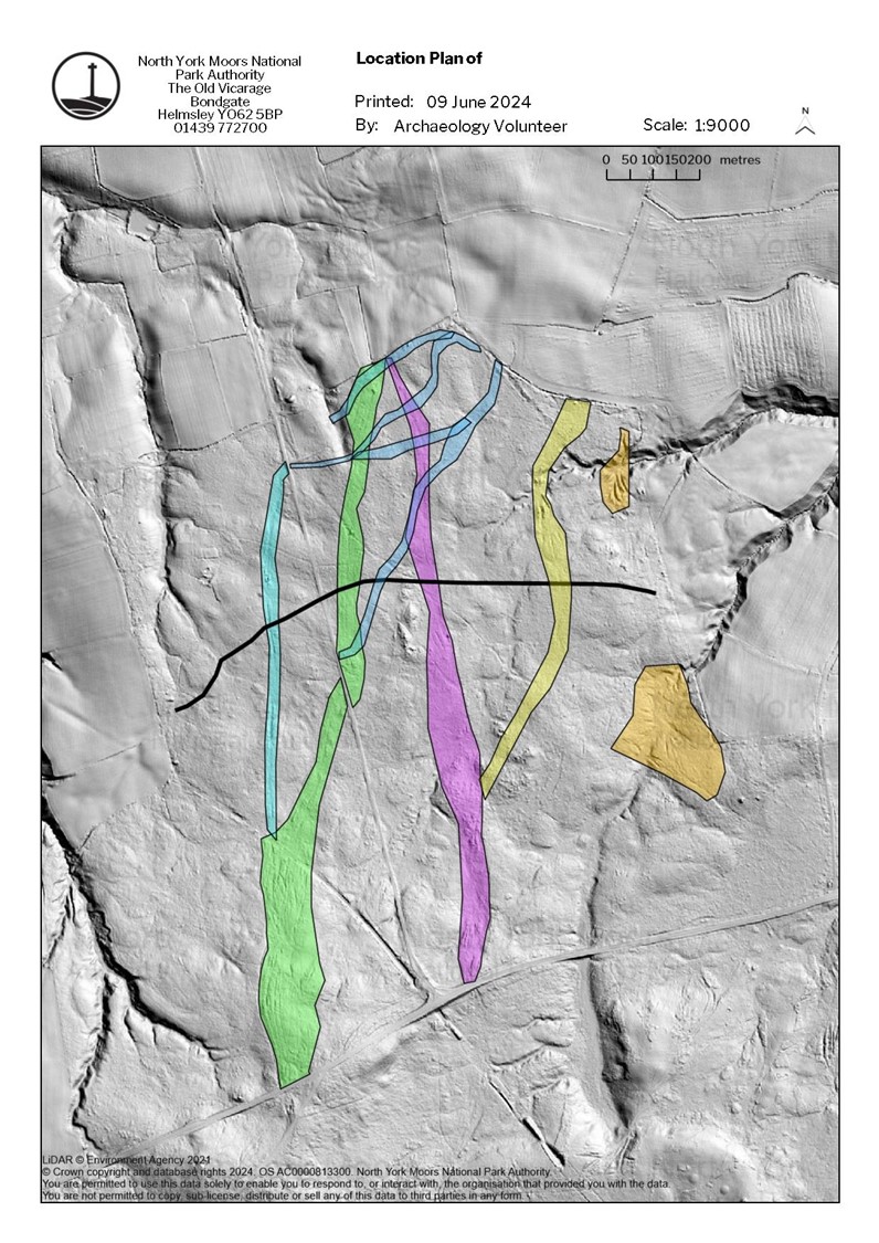
Phase 4 (dark blue) comprises of a series of related single or islanded hollow ways, which cut across phases 1 and 2 (Figure 24). Some elements are mapped on 1853 OS mapping, but not entirely. They apparently respect and join with the modern road, which is present on the 1853 OS map, listed as Liverton Moor New Road. This designation suggests that one of the adjacent hollow way complexes may have acted as the primary access in recent history. A putative phase 4 (light blue) feature has also been included, based on its double wide morphology, and the fact that it respects the line of the modern road, suggest its use coincided with the construction of this new road.
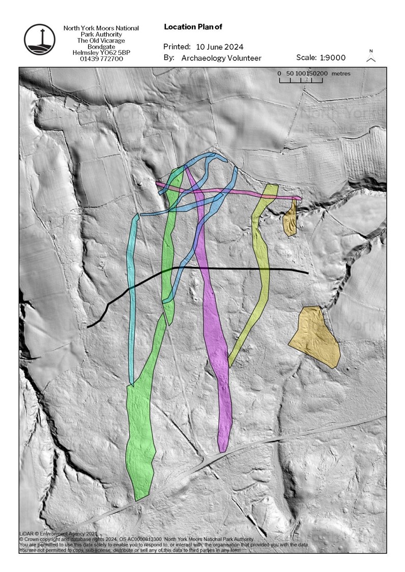
Phase 5 (pink) comprises a faintly incised feature which crosses the moor from east to west, cutting across features from phases 1 - 4 (Figure 25). It follows the line of an 1853 path and a modern right of way, a feature still in use today. It is lightly incised and runs between relatively modern farm buildings which suggests that the route is also relatively modern, possibly dating to the occupation of both farmhouses approximately in the 18th century.
Beyond establishing phasing, landscape-scale surveys can aid in the identifying sites for gathering absolute chronological data. If the structure of routeways can be followed through areas of peat, it may be possible to date the closure from the inception of peat above these features. If sediment has accumulated over an abandoned hollow way or erosive route incised into a suitable soil or bedrock surface, it could be possible to date these features using Optically Stimulated Luminescence (OSL), a method already applied to these features in the Netherlands (Vletter and Speck 2021). In this case, OSL would be most useful for dating short term erosive ways. In the case of buried trods, it may be possible to use OSL to date the underside of the trod stones (or sediment below them) as well as the topside, so that a chronology for the trod construction and abandonment can be established. This approach would follow a modified methodology for dating dry stone features similar to that created by Ageby and colleagues (Ageby et al. 2022; Malim and Hayes 2008).
LiDAR has been a revolutionary development for studying past routeways allowing for detailed mapping of these features at scale. Significant information can be gleaned from a landscape scale analysis including the different types of ways present, the patterns and ways of moving that they represent, and their relative chronology. This survey has mapped these features across an area of 75 km².
Further investigations, particularly through ground surveys and fieldwork, are needed for developing and implementing these new methodologies. Several potential methods have been highlighted in this article, such as the application of coring methods for mapping ways covered by peat, and LiDAR to identify areas where OSL and C14 dating could be used. Grappling with such complex stratigraphies on the ground will be integral to establishing the relationships between different ways and the implications of their morphology at a human scale. This will not only inform future scientific investigations but also provide experiential insights into the use of these features. Tying together the disparate evidence of trods into a coherent category may be particularly revelatory, adding much to the understanding of the medieval and post medieval routeway network at a national level.
Analyses of the differing use histories of these features are also needed to advance a holistic understanding of routeway networks, and a variety of studies need to be conducted on the social dimensions of these features. Exploring the movement patterns of different groups of people (such as drovers, monastic groups, political and military elites), the impact of changing settlement patterns, how uses and interpretations of routeways changed over time, and their role in the memory-scape, are all areas of particular interest.
A more intensive investigation into the management of these routeways is needed. Relying on incidental protections is no longer sufficient. These routeways must be protected on their archaeological merits and significance, whether through scheduling (from which they are traditionally excluded) or other appropriate mechanism. Those features still in use as public rights of way, which formed a significant subset of the sample, require sympathetic management, balancing their role in landscape access and their intangible heritage with the preservation of the archaeological monument.
We must seize the opportunity to investigate these routes more thoroughly, deepening our understanding of past mobility and highlighting movement as a dynamic process.
I would like to thank the North York Moors National Park Authority for supporting this PhD Project. The work of a group of volunteers associated with the Authority was instrumental for the data collection during this project, and they deserve particular thanks. I would also like to thank my PhD supervisors Jim Leary (University of York) and Miles Johnson (North York Moors National Park) for their guidance and support in publishing this article.
Funding both for the PhD, and for publication of this article has been provided by Anglo American plc through a Section 106 Agreement relating to the development phase of the polyhalite workings at Woodsmith Mine near Whitby. The agreement was initially developed with Sirius Minerals and was taken on by Anglo American during 2000 as part of the acquisition of Sirius Minerals. The development phase fund facilitated a lidar programme (which defines the mine corridor referred to in this article) and funds the enhancement of arising data for inclusion in the North York Moors HER.
Internet Archaeology is an open access journal based in the Department of Archaeology, University of York. Except where otherwise noted, content from this work may be used under the terms of the Creative Commons Attribution 3.0 (CC BY) Unported licence, which permits unrestricted use, distribution, and reproduction in any medium, provided that attribution to the author(s), the title of the work, the Internet Archaeology journal and the relevant URL/DOI are given.
Terms and Conditions | Legal Statements | Privacy Policy | Cookies Policy | Citing Internet Archaeology
Internet Archaeology content is preserved for the long term with the Archaeology Data Service (ROR). Help sustain and support open access publication by donating to our Open Access Archaeology Fund.
 Home
Home