Cite this as: Picker, A. 2025 Significance in the Suburbs: Grasping the 'Monument Syntax' of a Roman Town for Developers and Heritage Managers Alike (Brigantium/Bregenz, Austria), Internet Archaeology 70. https://doi.org/10.11141/ia.70.11
At the western-most tip of Austria, at the edge of the Central Alps and on the shores of Lake Constance, lies the modern city of Bregenz. Here, on a plateau between the lake and the mountainside, a multi-phased Roman military installation was founded in late Augustan times (Kopf and Oberhofer 2022). In the later 1st century AD and well into the 3rd century AD, the civilian town (possibly a municipium) of Brigantium flourished and came to include a forum, temples, baths and other public buildings (Oberhofer 2019; Rabitsch 2019).
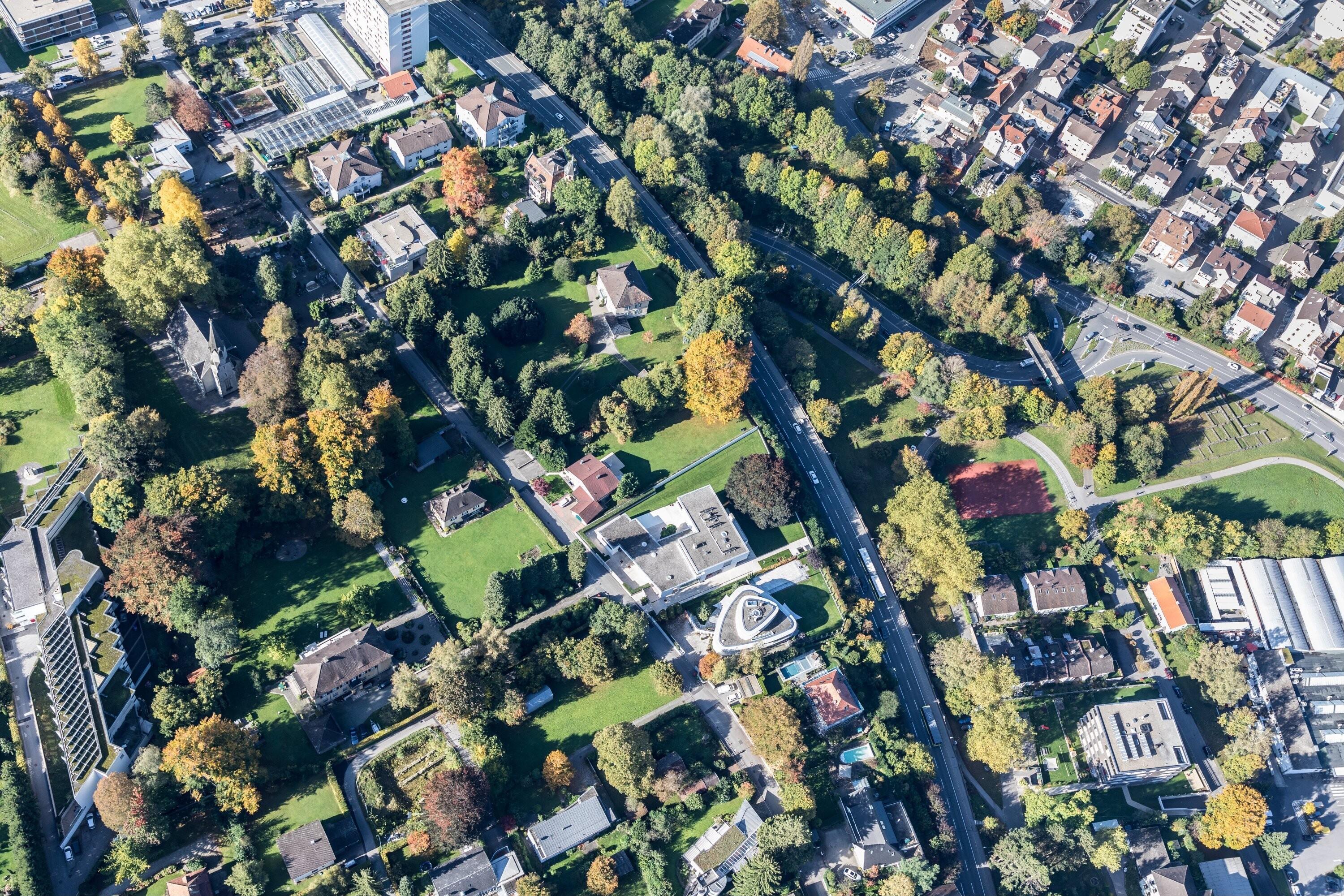
Following a settlement hiatus of over 1500 years, this specific area has been continuously developed since the late 19th century, with villas and gardens (Figure 1) that have themselves become a remarkable townscape worth protecting (Bregenz Townscape 2018). As there has never been any medieval or early modern construction, the state of archaeological preservation is outstanding in some parts, although only a few Roman buildings are now visible above ground. Today, Bregenz is a rather small state capital, with a population of c. 30,000. However, it is part of the quite highly developed and densely populated alpine Rhine valley, an agglomeration within the federal state of Vorarlberg, with a population of c. 400,000. Archaeology in Roman Bregenz is presented with a rather dense built-up area, of a suburban type rather than metropolitan. Land values are generally high in this region, even more so in the prominent residential area that coincides with the Roman town.
The archaeology (research and heritage management) of Bregenz takes place within a modern urban setting, but also within a settlement from the early and middle Roman periods. Both the Roman town and the modern suburb are 'cities', but entirely different entities, with little in common except their relationship in space.
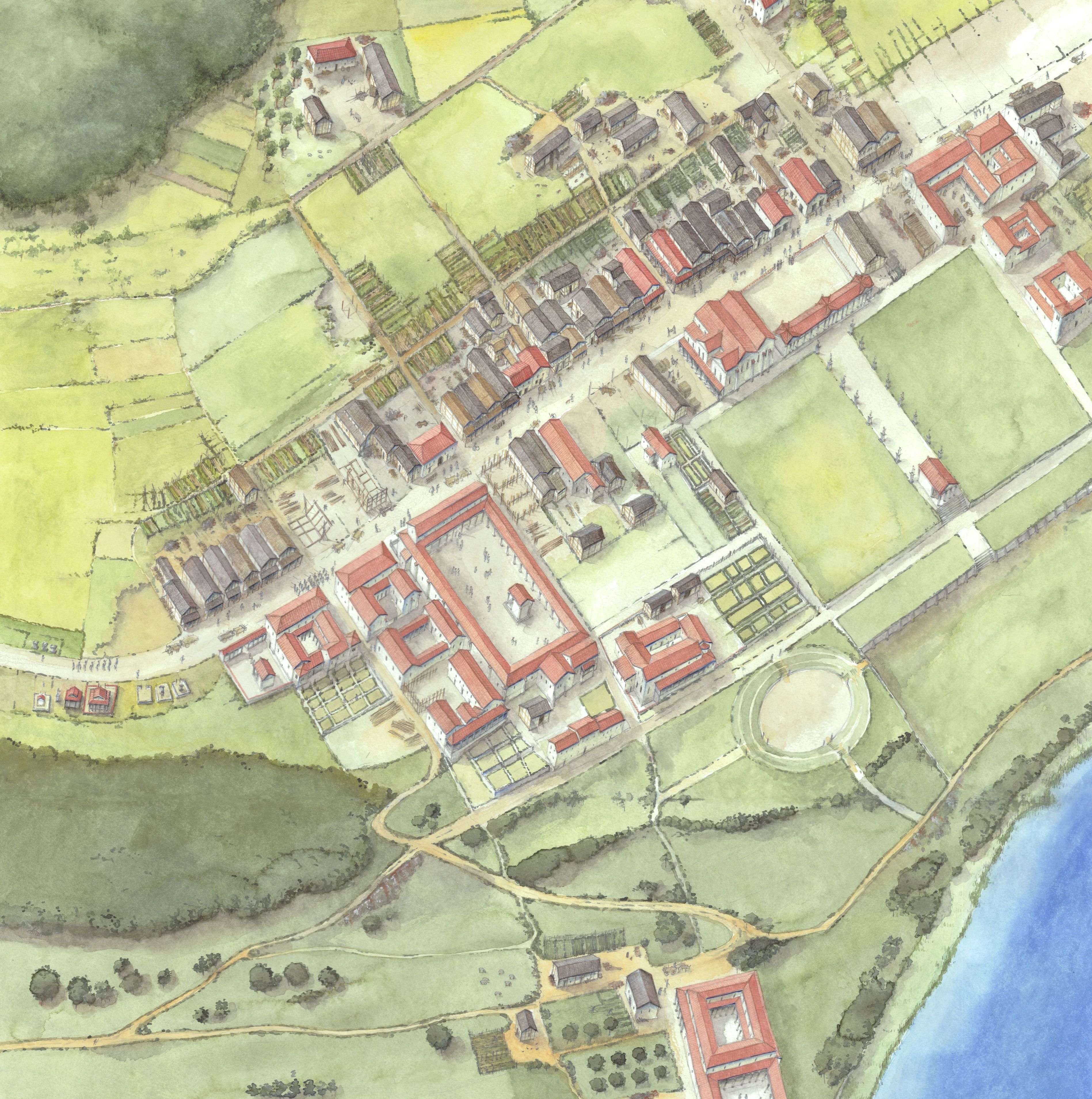
This paper aims not only to present the aforementioned case study (Brigantium), but also to reflect on the issues of assessment of significance and the associated methods and tools. Therefore, we may ask the question: What kind of monument (qualitatively speaking) is a Roman town? Even more so, a Roman town under a modern city? When we think of the archaeological monuments we are striving to protect, do we think of the Roman town the way it used to be (Figure 2) or of the way the town may be reconstructed based on the evidence we have (Figure 3)?
Often, we are not dealing with a historical reality, but with 'things' seemingly arbitrarily strewn across the townscape of today (Figure 4). Most of them have been partially excavated and refilled, destroyed by construction, or (in rare cases) preserved above ground (Picker 2023). This statement might seem trivial, but we must remember that the archaeological site itself is not 'the Roman town' as it once was or we imagine it to be, but a quite ambiguous amalgamation of remnants that form an element of the cultural heritage as it is seen today. These physical things need to be attributed with meaning in order to become 'monuments', but there can be no meaning without the material.
The assessment of an archaeological monument's significance, especially in an urban context, may therefore begin with its physical intactness, wholeness or integrity. Unlike elements of built heritage, which are generally better defined spatially and may (theoretically) be considered something close to '100%' intact, as long as their substantial and functional integrity is uncompromised, most archaeological sites (or complexes of stratigraphy) are 'ruinous' from the outset. Therefore, only their state of preservation at present can function as a baseline for an evaluation of their significance. The Austrian Monuments Protection Act makes a mention of this, at least regarding ruins (Monuments Protection Act 2024, § 1 section 8).
Generally, monuments possess a sort of dual nature, as 'things' constituted by physical artefacts and as mental concepts. The theoretical legal framework of heritage management and protection seems to take both aspects into account. The Austrian Monuments Protection Act (Monuments Protection Act 2024, § 1 section 1; Bazil et al. 2015) defines monuments (buildings as well as archaeology) as physical objects made by humans of historical, artistic and/or other cultural meaning (or 'significance'). These very general criteria can be summarised as the 'significance criteria'. The law also states that this significance must be evaluated based on “quality, quantity, diversity and dispersion of Austrian cultural property as a whole” (translation by the author). These 'evaluation criteria' provide some minimal guidance for assessing an object.
When discussing questions of significance across Europe, linguistic issues also arise. The term usually applied in German language documents and legislation is 'Bedeutung'. This literally translates as 'meaning' in the semantic sense. On a more mundane level, it may simply mean 'importance'. In 1923, long before any linguistic turn in cultural theory, the Austrian civil servants who wrote the text of the Monuments Protection Act presumably simply intended to say that an object needed to be important enough to be protected by the law. A recent amendment to the Monuments Protection Act (September 2024) includes one small change in the wording regarding the evaluation criteria. It now specifies that the monument's meaning/significance must contribute to the “quality, quantity, diversity and dispersion” of cultural property (Monuments Protection Act 2024, § 1 section 4). The mere fact that the monument is physically preserved does not suffice. Here, the underlying notion of 'meaning' clearly goes beyond the 'importance' of the monument but encompasses any kind of historical connotation or representativeness. The commentary to the amendment states, that “the meaning must result from the respective object, i.e. its substance, which is to be preserved” (Commentary to the Monuments Protection Act 2024; translation by the author). The physical object is still (inevitably) at the heart of the concept, but it would seem the criteria for its assessment have shifted more to the representational.
Clearly, this concept of monument significance, even since the writings of the Austrian theorist Alois Riegl, follows a rather constructivist (and less materialist) approach (e.g. Hebert 2015, 2017; Euler-Rolle 2020). Furthermore, the law may be read to imply that a protected monument becomes a static object to some extent, although re-evaluation of its significance is theoretically possible. In the past few decades, much has been written about monument axiology and the values humans attribute to monuments. Following architectural heritage theorists like Hermann Wirth, it has been said that 'monuments have no ontological existence'; they are constituted purely by the values people attribute to them in their minds (Wirth 1994; Euler-Rolle 2020). This occasional overstressing of the (doubtlessly existing) semiotic level of monuments and 'things' in general has come under increased criticism from the wide field of more recent neo-materialist theory (Witmore 2014; Hilgert et al. 2018; for a more critical view from Austrian anthropology: Hahn 2017; and a German language overview: Hoppe and Lemke 2021). Many aspects of assemblage thought, for instance, seem to go well with the objectives of archaeology, and archaeological heritage management in particular (e.g. Jervis 2019). These approaches generally stress that material things are 'things', and 'things' are physical assemblages that may convey meaning(s) but go beyond the purely representational.
In the context of a Roman town in modern Austria, we may, undoubtedly, presuppose that, for example, a stone wall, even if it has been semantically labelled 'Roman', without context is merely a mass of material. Attributing meaning to things makes them more accessible to humans, but also makes them become 'objects', while humans (or the human minds) function as the 'subjects'. However, material things may also be viewed not as mere representations of anthropocentric concepts but as assemblages or networks in their own right, that encompass the physical (like material properties, extension in space, etc.) as well as axiological or semiotic layers of meaning, both past and present.
The Austrian legal text takes this into account to some extent, as significance must always 'result' from the material substance. In an attempt to evaluate archaeological monuments of the highest significance in the country, the Austrian Federal Monuments Authority has conducted a project to define certain criteria, based on the concepts of integrity, authenticity, potential (for research) and impact (or public benefit). The methodology and results of this experimental undertaking are discussed elsewhere (Hebert et al. 2021), as well as in the forthcoming Europae Archaeologiae Consilium (EAC) guidelines on archaeological significance (EAC forthcoming). It has since become clear that assessment of significance must not be reduced to simply attributing intangible values, while the physical remains and their materiality are taken as a given. However, the pitfalls of unreflecting quantification (of actually qualitative data) must be avoided. Even seemingly very basic factors, like the sheer amount of preserved archaeological features of an individual site (and therefore its probable high integrity), contribute to a monument's meaning.
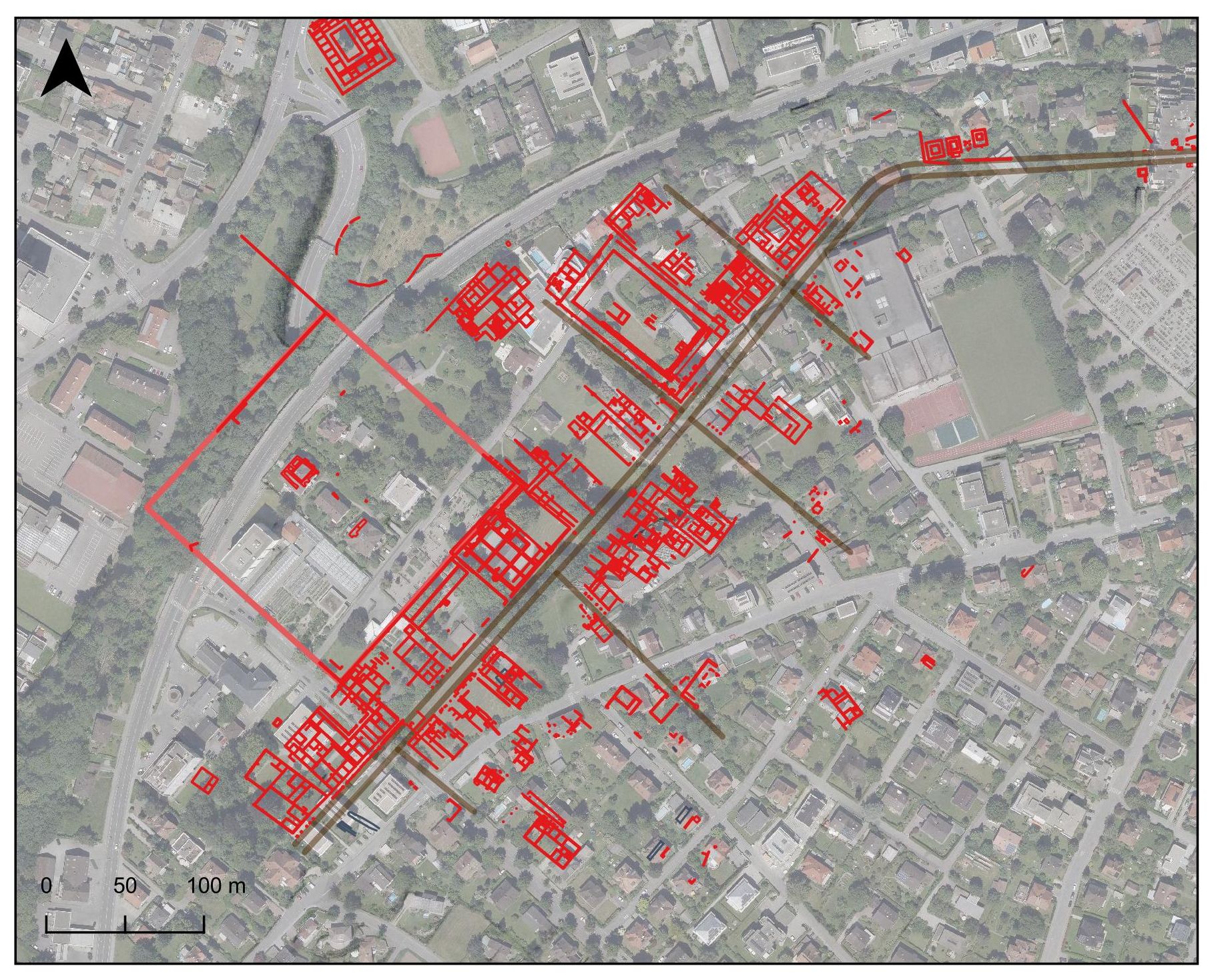
What are the implications regarding (urban) heritage management and the assessment (or simply the spatial definition) of archaeological monuments to be protected? Since 2016 a digital 'city map' of Roman Brigantium has been implemented on a web-based geographical information system (GIS) run by the city administration of Bregenz, following a digitisation project conducted by the Federal Monuments Authority and the Vorarlberg Museum in Bregenz. Since then, all architecturally relevant findings from plans and site records have been scanned, georeferenced and digitised (Oberhofer et al. 2016; City Map). The two-dimensional (2D) dataset of this GIS map has become a valuable tool, both for research as well as for heritage management. Naturally, the city map is an abstraction or amalgamation based on findings and evidence gathered since the 19th century. We need to remember, therefore, that Roman Brigantium at no time in its history looked exactly like this map (Figure 3). Most of the digitised features date from the era of stone buildings from the late 1st century AD onwards, with only a few from the military or early civilian settlement period. A differentiation between the periods has not yet been possible because of the complex history of research (Oberhofer et al. 2016; Oberhofer 2020).
This plan alone does not entirely represent the protectable monument, or the significance we need to attribute to it. For the next step, it is necessary to look beyond the reconstructive view of the archaeological site based on the idea of an ideal Roman town, and grasp the monument defined by the existing physical remains (Oberhofer and Picker 2022). Furthermore, we need to understand the archaeological monument as a three-dimensional (3D) object of varying quality, and horizontal as well as vertical expansion (depth) in space.
In recent years, there have been several relevant archaeological interventions in the peripheral areas of the Roman town. However, most of what is known about Brigantium's urban centre is based on fieldwork carried out from the 1860s to 1990s. The early documentations include no or hardly any elevation data or drawings of profile sections. From the 1920s and 1930s, several profile drawings exist from excavations carried out in the course of smaller building projects, almost exclusively by the Vorarlberg State Museum (today's Vorarlberg Museum). From the second half of the 20th century, we find some accurately surveyed and drawn sections in the excavation records that demonstrate an impressive stratigraphy of up to 3m in the centre of the Roman settlement.
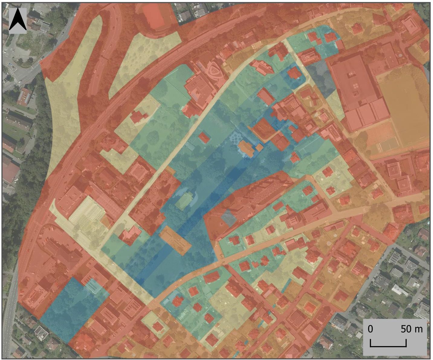
Based on the elevation evidence from the stratigraphy, and also using a good deal of experience-based judgement and interpolation, a rough mapping of areas of relative high and low levels of intact archaeological substance was possible (Oberhofer and Picker 2022) (Figure 5). Far from being a true 'predictive model', this experimental visualisation demonstrates a new aspect of the monument's properties: Brigantium's urban centre as a mosaic of the varying depth (or 'thickness') of its stratification, a complex of existing and expected archaeological features (Figure 5, blue to orange), leaving out the destroyed areas (red). Technically, this image is simply an analogue mapping of values from the known elevation data extrapolated to surrounding areas, roughly equating to individual land plots. The main road (decumanus), running south-west to north-east, and its immediate vicinity has repeatedly shown the greatest accumulation of layers, with a thickness of up to 3m, excluding the recent top soil. In horizontal space, there is a lateral decrease of this thickness in both directions from the main road. Naturally, this decrease of stratigraphic complexity towards the periphery of the settlement is not linear. Some areas have been disturbed by destruction (mainly modern construction), while others run deeper, like the v-shaped trenches of the early military camp in the south. In general, however, most of the strip houses towards the south-east show a less complex stratigraphy and fewer building phases, because of their erection in a later settlement period. The areas of former archaeological excavations are generally not classified as totally destroyed. As has been shown in recent excavations, the refilled trenches of earlier archaeologists hardly compromise the monument's integrity as a whole (Oberhofer 2019; Oberhofer 2020; Kopf and Oberhofer 2022). The areas shown in shades of blue in Figure 5 contribute the greatest amount of substance to the monument. This does not mean that the peripheral areas are necessarily lacking in quality. However, the greater mass of multi-phased features and the greater complexity of the central urban area might be considered more meaningful or significant, if this choice has to be made.
The level of substantial preservation (criteria like '3m of stratigraphy' or '100 documented stratigraphical units') is a major indicator of the level of integrity, even if we do not wish to equate the former with the latter entirely. As mentioned before, the monument's completeness can only be measured by its state at present. Only future processes of management and change will show how much loss, how much decrease in wholeness, will be tolerable. Defining legal protection areas or 'zones' based on a map of 'quantitative' integrity alone, however, is not feasible: '1m' of strata of a Roman temple may be more significant than '2m' of standard living quarters. For this reason, other more 'qualitative' criteria (authentic transmission, value for research, public benefit) must factor into the assessment as well.
While monument significance must ultimately be addressed semantically ('meaning' or 'values'), it is based on a complex assemblage of physical properties, connections and 'inner workings': networks of traffic and trade, shape and size of the architecture, even the mineral components of the stones used as building materials. In keeping with the linguistic analogy, we may address this complex system as a sort of 'monument syntax'. In fact, even scientific interpretations (past and present), or human reflections upon and interactions with the physical remains, should be viewed as parts of the integrative 'thing' that 'is' the monument.
We may ask whether we can (quite literally) 'map out' levels or layers of significance for an urban archaeological assemblage in conjunction with the expanse of its remains, as discussed above. The most direct form of documenting a site's complex nature is, undoubtedly, through the excavation record and a stratigraphic matrix. The sometimes extreme complexity is one important characteristic of urban archaeological assemblages. The fact that a great amount of information even exists can be an argument in the assessment and help to 'make choices', if it is extrapolated to the preserved, not excavated, areas of the site.
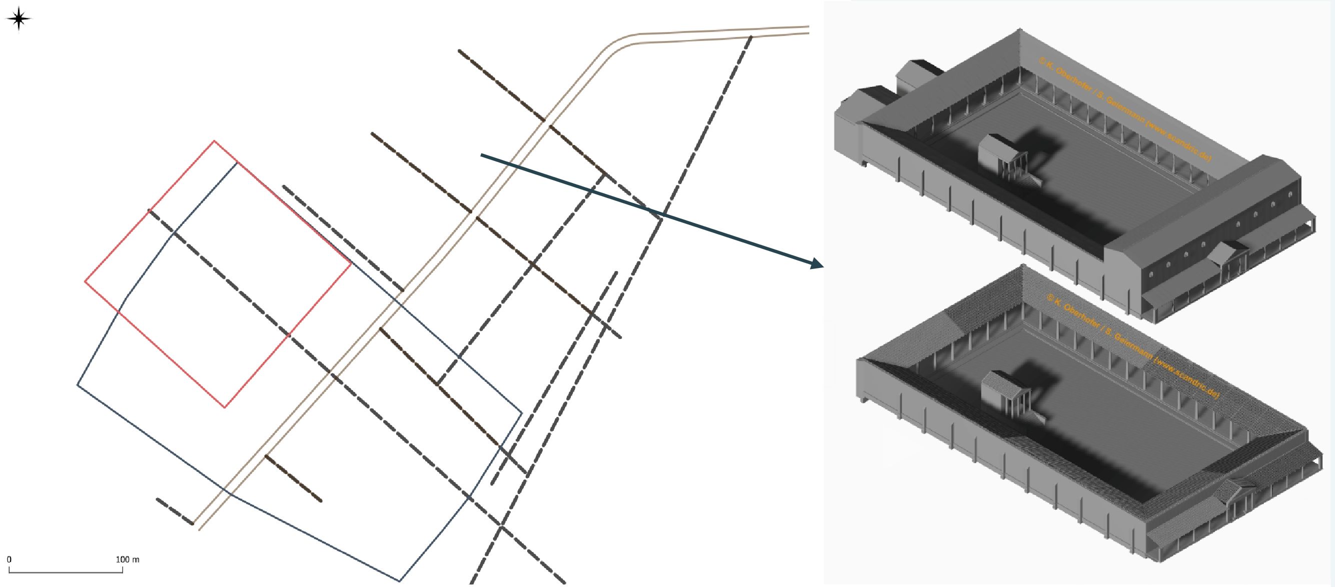
Another 'layer' in the syntax of significance might be the abstract entities (or 'objects') that make up the urban infrastructure (streets, public buildings, insulae, etc.). In the case of Bregenz, the polygonal early imperial military camp (Figure 6 in grey) overlaps in part with the sacred district, probably used for the imperial cult (in red). Recent research has shown that the first civilian forum-like assembly building might have followed directly after the military principia. Later, the larger forum was moved to the north-east, expanding in at least two building phases (Oberhofer 2019). Quite straightforwardly, our growing understanding of Roman era settlement planning contributes to (or alters) the attributing of significance.
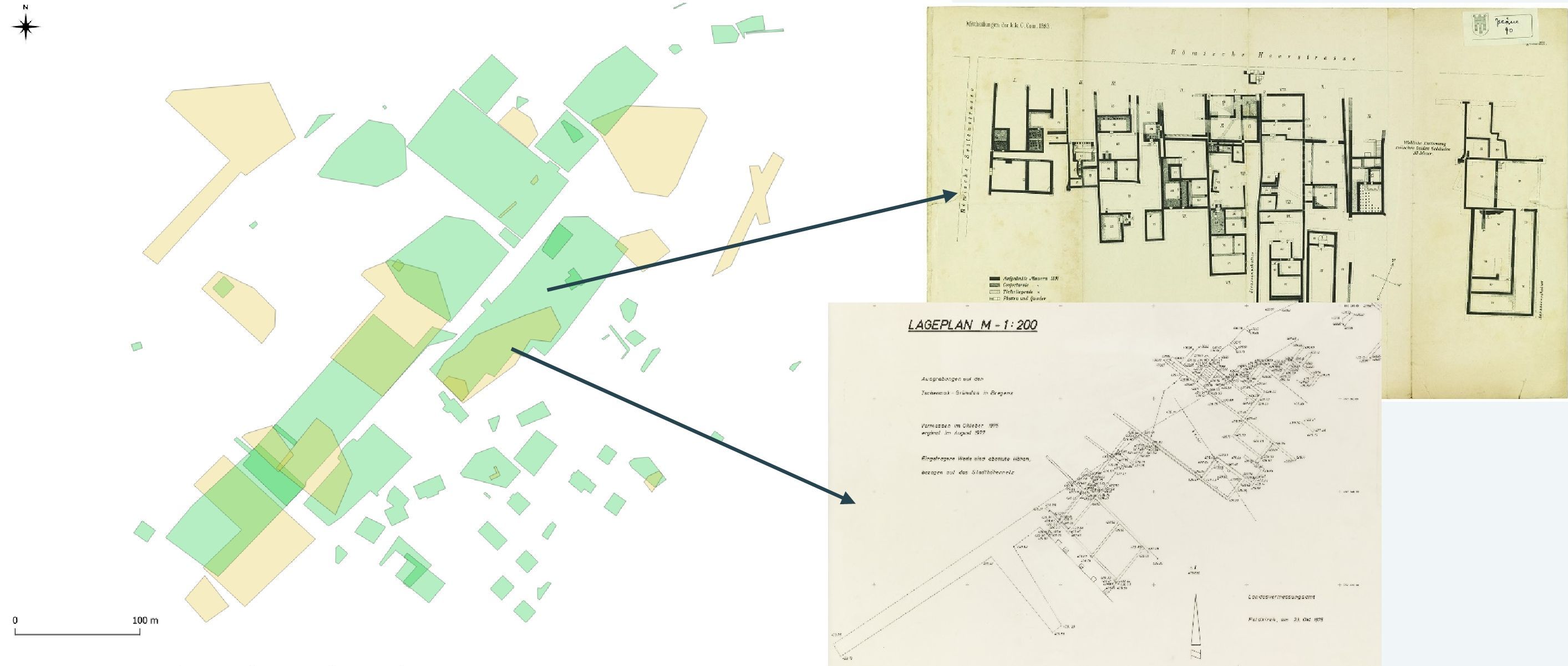
A somewhat subtler 'layer' of meaning addresses the quality and credibility of the available source material, like the historic site records, drawings and plans that make up our knowledge of the Roman town. Such source criticism is a necessary step in the workflow of digitisation projects. However, the visualisation of 'where and what' of the excavation plans used to digitise the city map can show us the density and quality of the evidence. Was a historic, maybe not quite accurate, plan used (Figure 7, green), or a surveyed and georeferenced plan from the second half of the 20th century (yellow)? One might go as far as to say that the paper evidence is itself a part of what Brigantium means to us today.
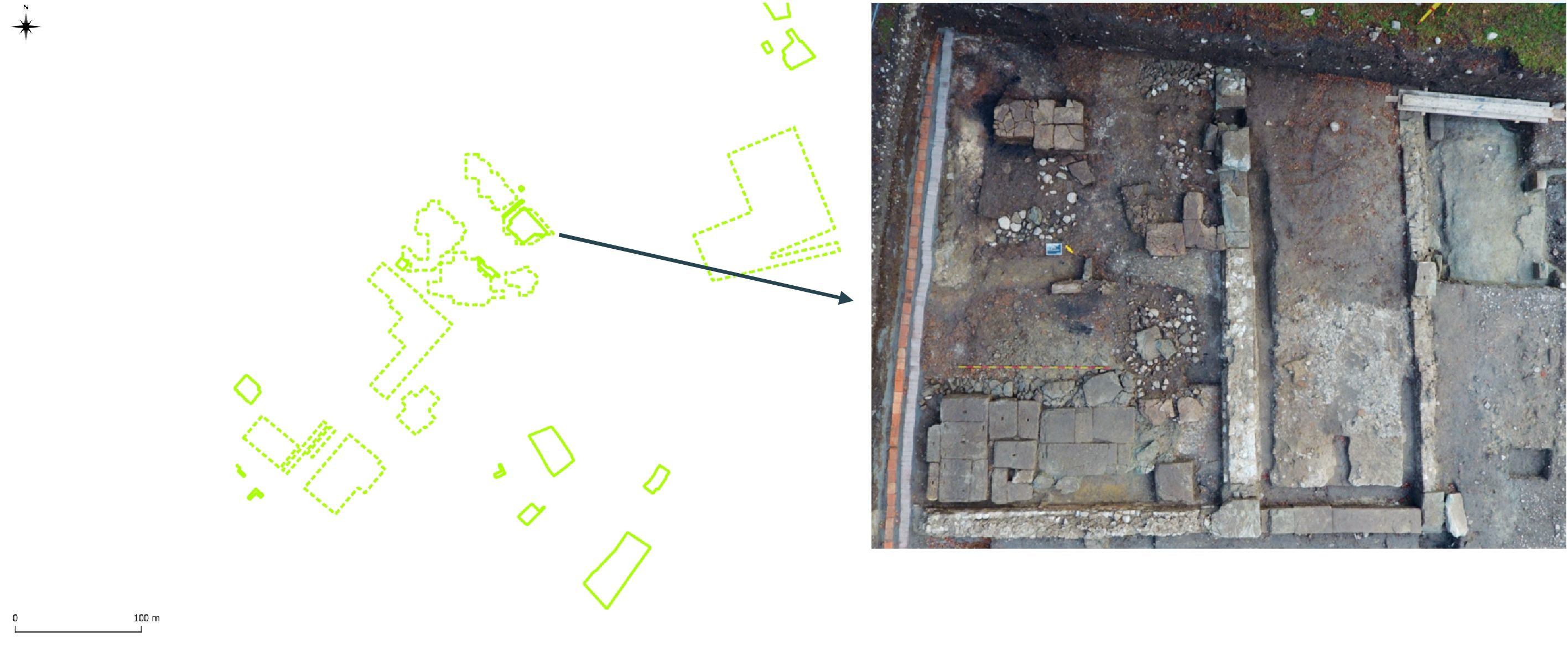
The question of 'credible sources' leads in the direction of 'authenticity'. It is also connected to the extent and intensity of the more recent archaeological interventions. Were they intrusive excavations (Figure 8, continuous line) or, for example, geophysical prospections (hashed)? How large an area has been investigated, and how does this influence the attribution of significance?
The issues discussed in this paper stem from several different cases and projects dealt with by the author over the last several years within the professional framework of regional archaeological heritage management. While the legal process of monument protection in Austria emphasises the aspects of 'significance' and 'meaning' as qualitative values, the 'material turn' in general and, possibly even more so, the technical advances (especially GIS, surveying methods, etc.) on an everyday level, have increased our perception of archaeological sites and monuments as spatial entities. The mapping and visualisation of not only findings and features, but of aspects like preservation potential and even source criticism and research objectives, may lead to a more transparent and comprehendible qualitative assessment of monuments in general. Ultimately, we may be able to produce not only a 'top-down' values-based concept of a monument that might never have existed in that way in the past, but a true 'bottom-up' model of the monument preserved and worth preserving.
Whether we speak of networks, assemblages or syntaxes, it is imperative to grasp the structure of archaeological monuments as entities that are more than representational. A preserved monument, especially, has the potential to convey meanings other than the time-bound perceiver of the past or present would think possible. This outlook upon future, yet unknown, meanings based on a preserved and transmitted material heritage may be considered a monument value in itself. In modern urban contexts, this promises to have a positive impact on planning and the identities attached to being 'urban'.
Internet Archaeology is an open access journal based in the Department of Archaeology, University of York. Except where otherwise noted, content from this work may be used under the terms of the Creative Commons Attribution 3.0 (CC BY) Unported licence, which permits unrestricted use, distribution, and reproduction in any medium, provided that attribution to the author(s), the title of the work, the Internet Archaeology journal and the relevant URL/DOI are given.
Terms and Conditions | Legal Statements | Privacy Policy | Cookies Policy | Citing Internet Archaeology
Internet Archaeology content is preserved for the long term with the Archaeology Data Service (ROR). Help sustain and support open access publication by donating to our Open Access Archaeology Fund.
 Home
Home